Army in 3D

24
In a training battle, a reconnaissance motorized rifle unit per unit of time must obtain as much information as possible. You need to take into account everything: the location of the enemy, features of the terrain, the presence of ditches, dells, communications. One visual observation is not limited to this; aerial reconnaissance carried out by an unmanned aerial vehicle will be a good addition.

All collected data is received by the deputy commander of the reconnaissance platoon. For their analysis, he uses a personal computer, which is a kind of information center for conditional combat. It receives all the information that the department manages to collect: photographs, coordinates of possible targets. It is possible to display the location of their troops and enemy units, attack routes, lines of defense, artillery strikes.

All received information about the situation on the battlefield is displayed on a special interactive electronic map. It allows you to watch the full picture of the battle. One could only dream of such possibilities when using ordinary paper cards. According to Anton Apanasenko, who acts as the commander of the reconnaissance battalion, published on the Vesti website, previously a lot of time was spent on building various graphs, building relief relief pictures, used to determine the appearance of objects. When using an electronic map, all this information is updated with a few mouse clicks every second.
The development of military electronic maps is handled by the 38-th Central Aerophoto-Topographic Detachment, located in Noginsk, Moscow Region. Here a huge number of satellite images are drained, after which they are tied to the terrain in the coordinate system. On the basis of photographs made maps. The squad commander Alexey Anisov notes that the unit uses only Russian-made equipment and software used directly in the process of creating topographic maps in electronic form. Currently, digital versions of space aerial photographs are used for this.

Detailed digital maps become military after the application of various objects in the center of geo-information support. Here the strategy of combat operations is worked out, the positions of the enemy troops and their troops are taken into account. According to the head of the center, Igor Rutko, the use of paper cards is gradually reduced. The main work is now carried out with the use of topographic maps in electronic form, which make it possible to move from observing the general structure of army troops to one soldier in a trench.

According to military cartographers, the potential of using electronic maps is inexhaustible, in the near future they will become a real database. For example, to obtain information about the carrying capacity of a bridge or the depth of a river, it will suffice to hover over their image. All this will allow increasing the effectiveness of troop movement, which will become an undoubted trump card in modern battle conditions.
24 comments
Information
Dear reader, to leave comments on the publication, you must sign in.
  1. +4
    9 January 2012 09: 44
    The use of new technologies in the army is good. High awareness, mobility, high training increases the combat effectiveness of our army in modern conflicts of our time.
  2. Nomad2
    +2
    9 January 2012 11: 06
    Yeah, of course. Adrianova’s compass and three-year map will be the main means of satellite navigation in the army for another 20 years.
    And, I almost forgot, each Vanka-platoon must have a faceted, multi-functional pencil.
    To be honest, I just can’t believe in all these miracles at the platoon level.
    1. Alexey Prikazchikov
      +1
      9 January 2012 11: 14
      Time will tell, but it seems to me they are realizing it.
    2. Aleksey67
      +3
      9 January 2012 12: 17
      I read somewhere about the purchase of UAVs for reconnaissance, the cost of the complex is 2,5 million rubles (in numbers I could be mistaken, but not by much). Will they trust the sergeant with such a technique?
    3. marauder
      0
      9 January 2012 17: 59
      Chapai built an interactive map of potatoes on the table.
      Now, to see the map, you will need to carry a suitcase of batteries.

      These are all western things. Really, while something there, consider you already banging. In Pindos who use such things, the reaction to the environment is inhibited.
      1. WADIM
        0
        9 January 2012 19: 01
        I agree with you about potatoes ... but with all the rest there is absolutely no .....
        1. marauder
          +3
          9 January 2012 20: 15
          for the general at headquarters, this is good. But for the field is not good.
          I understand something I want so fancy, in the films of different fiction there they show.

          What the author wrote in this article is called "Network-centric warfare".
          By the way, Russian election, Pindos are trying to apply.

          A person is not able to operatively process the information received.
          Try to play strategy on your computer during the battle.
  3. Alexey Prikazchikov
    0
    9 January 2012 11: 14
    The good news is on the sedan.
  4. dred
    -1
    9 January 2012 11: 20
    You are right, the news is good, and perhaps we will come up with good news.
  5. itr
    +6
    9 January 2012 12: 12
    Has anyone tried to use beech on the street in winter? and in combat it will be just gorgeous.
  6. +1
    9 January 2012 12: 35
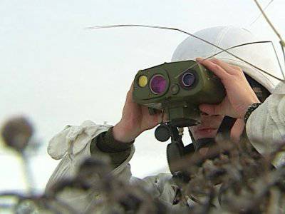
    Who knows what kind of device is on the first photo?
    1. +3
      9 January 2012 13: 01
      Here it is:


      The analogue of this:

      The RLD-1,5 handheld laser rangefinder for long distances, with an integrated power supply, combined with a visual monocular and designed to provide the ability to observe, sight and accurately measure the distance to the object in daylight and, with additional equipment, in the dark, by using a safe laser radiation.

      Key Features:
      • Optical sight with high magnification 8x
      • Diopter focusing of the eyepiece.
      • Logic of highlighting the first or last reflected signal.
      • Stand-alone AA batteries.
      • Built-in compass and GPS.
      • Work with an external power source (when connected via a special cable).
      • Optional rangefinder components (optional equipment).
      1. WADIM
        0
        9 January 2012 19: 02
        Thanks for the info! smile
    2. 0
      9 January 2012 13: 15
      I can’t determine the exact model by type, but I know the analogue ...

      The RLD-1,5 handheld laser rangefinder for long distances, with an integrated power supply, combined with a visual monocular and designed to provide the ability to observe, sight and accurately measure the distance to the object in daylight and, with additional equipment, in the dark, by using a safe laser radiation.

      Key Features:

      • Optical sight with high magnification 8x

      • Diopter focusing of the eyepiece.

      • Logic of highlighting the first or last reflected signal.

      • Stand-alone AA batteries.

      • Built-in compass and GPS.

      • Work with an external power source (when connected via a special cable).

      • Optional rangefinder components (optional equipment).
      Technical specifications
      Viewfinder Type Monocular
      Viewfinder field of view 5,6°
      Reticle magnification 8x
      Viewfinder resolution on axes, arc sec 6
      Wavelength, µm 1,54
      Output energy, mJ 10, nominal
      Eye safety category Class 3a. NOHD=0m
      Radiation divergence, mrad 0,6
      Attenuation coefficient at reflectance=85% target 38 dB at 500 m
      Measured distance range, meters From 20 to 20000
      Accuracy, meters ±5
      Measurement frequency 6 pulses per minute
      Logic Isolation of the first or last signal
      Selection of objects, m 30 m
      Receiver type InGaAs APD
      Compass* Bearing accuracy 7°
      0,4 ° elevation accuracy
      Range of measured angles ± 40 °
      GPS Accuracy* Horizon 9m (90% probability)
      Height 14 m
      Speed ​​0,6 m / s
      Operating voltage (external), V 10-32
      Weight, kg 1,8

      * - by an additional order
  7. Farkash
    +1
    9 January 2012 14: 04
    Indeed, great news, in a modern war of high-tech armies without such equipment - kirdyk. It is interesting what reliability and efficiency are in real combat conditions and what methods of protection a potential adversary can apply from similar technologies.
    Still, I would like to take a closer look at the electronic components of the laptop and the UAV, to dig into the copper intestines. smile
  8. 0
    9 January 2012 17: 42
    In a modern theater of operations, the use of high-tech weapons is a real necessity. But there are still quite a few questions about this.
    How ? The most equipped army in the world, with a constellation of satellites in orbit, all-weather UAVs, all kinds of sensors and sensors. As the United States is losing, it’s not literate Iraqis (who don’t understand any gadgets ... and no Afghans).
    The motivation of a soldier to fight, to be a fighter, to stand to the end are perhaps more important than the ability to call a military helicopter for evacuation via satellite.
  9. +2
    9 January 2012 17: 43
    Actually, the article should be copyright ...
    from the rules:
    Attention! On "Voennoye Obozreniye" we post only articles written by you personally
    .

    And Alexander Dedov simply outlined the report of V. Akinshin. However, I did not even bother to make a link to the original and to the author.
    Therefore, I am neglecting the article and restoring justice, the original report on the link http://krasview.ru/video/c7bdd3d38495292
    1. 0
      9 January 2012 21: 51
      And my article is not added at all, although I myself write
  10. 0
    9 January 2012 20: 27
    Good! But more like announcing a project.
    If only the introduction of such a technique did not affect knowledge when working with a regular map, compass, curvimeter, and ability to navigate the terrain. And then, then the batteries were not brought up, then the device broke down, then the operator fell ill, then ......... in the war, as in the war.
  11. 755962
    +1
    9 January 2012 20: 44
    These are the Stunts at our OMZ that are stamping. And not only them, there are a lot of developments. May God be in the army. Well, or the best ..
  12. 0
    10 January 2012 00: 29
    And here are the RLD Analogs:

    Laser binocular range finder LRB-20000
    Binocular rangefinder "LRB-20000" is intended for:
    a) monitoring the terrain and individual objects and measuring the distance to them;
    b) determining the polar coordinates of objects on the ground and converting them into rectangular coordinates;
    c) determining the coordinates of the instrument standing point from the known coordinates of the landmarks;
    d) orientation relative to cardinal points.

    BAE Systems
    Allows you to detect a standard NATO target (2,3x2,3 m) at ranges up to 8 km in the optical and 0,9 km in the infrared channels. Range (with an albedo of 10%) is determined at a distance to the target over 10 km at night and over 15 km during the day.
    The accuracy of angular measurements is up to 8 divisions of the protractor in azimuth (accuracy increases eight times in 1 minute) and up to 4 divisions of the protractor in elevation (accuracy increases four times in 1 minute). GPS accuracy is submeter. Localization of target coordinates is automatic.
    The system is not intended to directly highlight the target at the time of its attack; its purpose is different.
    The device allows you to automatically determine the exact coordinates of the target in a single geographical coordinate system, and not relative to visible landmarks. This allows you to ensure its defeat by any suitable means of any kind of troops without visual contact with the target or with any local landmarks, which may simply not be at all.

    Max. range (m): 1465
    Min range (m): 5
    Accuracy (m): 1
    Horizontal Measurement: Yes
    Ballistic Calculator:
    Display: LCD
    Grid Illumination: Yes
    Lens (mm):
    Increase (fold): 7
    Line of sight :
    Eyepiece Focus:
    Power: 9 volt alkaline batteries (included)
    Laser wavelength (nm):
    Working temperatures:
    Country of Origin: China
    Warranty (years): 2
    Housing ergonomics design: robust metal housing, in a rubber waterproof shell, black
    Dimensions (mm): 43 x 129 x 94
    Weight (grams): 343
    Complete set: the set includes a case and a belt.
    Optional: special, anti-fog coating Rainguard® HD, three operating modes, for any environmental conditions, patented optics coating
  13. climber11
    +1
    10 January 2012 03: 38
    Such reports give the impression that this is happening on another planet. Until now, in the troops, a piece of iron called "PUO", okay at least the rangefinder does not need to be carried together, KShM based on MTLb with devices of the seventies, standards for calculating corrections using a pencil, formulas and paper. Tell me, in which departments, except for specialists, have all this? sad
    1. 0
      10 January 2012 19: 42
      The price of RLD-1,5 binoculars is over $ 10.000 and manufacturers are not spoiled by orders, to put it mildly. Our troops have no device of this model.
      I don’t know about other analogues.
  14. beech
    0
    4 February 2012 21: 42
    Better to do better binoculars, thermal imagers are good and cheaper ..., it’s too early for general use of tablets, and it’s not really necessary
  15. 0
    4 January 2015 13: 27
    This should be the army of the 21st century. Without papers and other archaisms.