Who orients the army and navy in space
 One of the main types of operational (combat) support of associations, formations and units of the Armed Forces of the Russian Federation are topographic, geodetic and navigation support, which has received increasing attention recently. Its content includes the timely delivery to headquarters and troops of accurate and reliable topographic and geodetic information necessary for assessing the terrain when making decisions, planning and conducting combat operations, organizing interaction and control of troops, as well as for the effective use of systems weapons and military equipment.
The topographic service of the Armed Forces of the Russian Federation is an organizational, scientific and production potential that is able to prepare topographic and geodetic information for any part of the earth's surface as soon as possible. The main task of the Topographic Service in peacetime and wartime is to create a model of the surrounding space in which troops and forces operate, with parameters that satisfy all types of modern weapons and military equipment in accuracy and relevance.
First of all it is:
- constant refinement and bringing to the military authorities and troops the parameters of the state geocentric coordinate system PZ-90, the main parameters of the Earth’s gravitational field, necessary primarily for the use of strategic nuclear weapons;
- geodetic binding of the entire infrastructure of the types and types of troops of the Armed Forces, the development of special geodetic networks in the interests of providing troops;
- creation and updating of digital topographic, analogue maps, creation of digital relief matrices and other geospatial data in the interests of ensuring the use of high-precision weapons, the functioning of automated control systems, planning the use and management of troops;
- providing troops with navigation equipment of the GLONASS system and its functional additions, organizing the operation of this equipment in the troops.
The primary tasks of military topographers in wartime are the prompt correction of topographic maps (changes on the ground resulting from military actions are indicated), control of the accuracy of topographic and geodetic referencing of the battle formations of rocket forces and artillery, the creation of special maps and terrain models, the preparation of military support cards, etc.
At present, the actual task is to provide automated troop control systems with digital topographic and geodetic information.
Experience shows that traditional topographic maps on paper are still the main information document of a tactical commander. In this connection, the tasks of the topographic service for their creation and bringing to the troops remain relevant.
AIMED AT VISION
On the system of navigation support of the Armed Forces of Russia, special mention should be made. Methods of topographic, geodetic, and navigation support are very close to each other. The organization of navigation support for the Armed Forces is currently in a state of development.
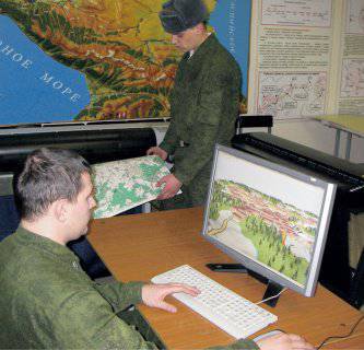
Specialists of the Topographic Service of the Armed Forces of the Russian Federation (in accordance with the normative legal acts of the Ministry of Defense of Russia) are directly involved in the development, testing, acceptance of satellite navigation equipment and means of functional additions (hereinafter - ASN and SFD). More than 40 thousand sets of such equipment have already been delivered to the troops. Moreover, modern satellite navigation equipment is equipped with systems allowing visualization of electronic topographic maps on the screen of the navigation receiver (Orion, Grot-M). Navigation equipment is not the subject of equipment of every soldier now, but this is a matter of a very near future. The actual supply of the Armed Forces with modern ASN and SFD samples in 2012 was 50%, in 2014 was 85%. The forecast of the security of the Armed Forces with satellite navigation equipment and means of functional additions up to 2020 is 100%.
In 2014, a new military geo-information system “Operator”, adopted for supply in 2013, was actively introduced in the Armed Forces. On the basis of this geographic information system, the planning of combat operations is carried out on the basis of electronic topographic maps in all structures and units of command and control of the Armed Forces of the Russian Federation.
The topographic service of the Armed Forces of the Russian Federation is an integral and one of the oldest components of the military organization of the state, performing an important function in the topographic and navigational support of troops (forces). Its theoretical and practical foundations are formed by a long historical evolution of views on the nature of command and control and methods of using forces and means. The Topographic Service is faced with the most serious tasks of saturating prospective systems of command and control of troops and weapons with relevant geoinformation resources, without which the tasks of the military structure of the state are impossible.
Currently, a functionally complete, high-tech and effective system of providing military command bodies, troops (forces) and weapon systems with modern means of topographic, geodetic and navigation information in digital and analog forms that meet the requirements for the maximum updating of information on terrain and objects is being gradually created. prospective system of providing the Armed Forces with geospatial information.
The main directions of development of the system for topographic, geodetic and navigation support of the Armed Forces
- introduction and development of automated means of the System of topogeodesic support of the Armed Forces of the Russian Federation and the creation of a metadata base, the development of modern GIS VN (geographic information systems for military purposes);
- determination of the list of spatial data, requirements for their creation and updating, the procedure for maintaining a fund of spatial data for the defense and security of the state;
- development of new standards for meeting the needs of troops (forces) in topographic, geodetic and navigational information, taking into account the modern look of the Armed Forces, changing the forms and methods of their use;
- revision of the standards for the content of analog cartographic products at the bases (warehouses);
- study and preparation of proposals for improving the system of providing troops (forces) with topographic, geodetic and navigation information;
- improvement of the system of multilateral military cooperation with the CIS member states on the basis of long-term planning and transfer of the main efforts to practical measures in the field of topogeodesic and navigation support of the armed forces of the CIS member states.
AUTOMATION AT ALL LEVELS
In the near future, the Unified Automated System for Providing the Armed Forces of the Russian Federation with Geospatial Information (EASO GPI) and the Software and Hardware Complex for the Operational Creation and Updating of Digital Information about a Territory (PAC CO CIM) will form the basis of the system for providing the Armed Forces of the Russian Federation with geospatial information.
EASO GPI and PAK SO TsIM are designed to create (update), collect, record, store, replicate and bring geospatial information on a time scale close to real, through closed communication channels to military authorities and troops (forces). EASO GPI will include the main and regional (district, army) data banks and geospatial information data banks of the compound. PAK SO CIM was created on the basis of Russian developments and will ensure the prompt creation of electronic maps to any region of the globe according to remote sensing data from space.
In accordance with the instructions of the Minister of Defense of the Russian Federation, Army General Sergei Shoigu, electronic cartography centers are being established in military districts, which will provide the military authorities and troops with digital geospatial information over high-speed data transmission channels. At the final stage, work is underway to create basic components of a geospatial military platform for automated control systems that will ensure the collective work of officials with geospatial information.
In addition to the mentioned EASO GPI and PAK CO CIM, in 2014, the 30 modern armored mobile navigation and geodetic complexes PNGK-1 were sent to the troops, the central military command, unions, formations, military units, military educational institutions and organizations of the RF Armed Forces are equipped with modern geoinformation systems military use (GIS VN) "Integration-64", "Operator" and "Map-2005" (more than 1500 sets purchased). PNGK-1 will provide the solution of the tasks of the Topographic Service of the RF Armed Forces to control the aiming of the launch and firing positions of the rocket forces and artillery, the Strategic Missile Forces, the Aerospace Defense troops, and GIS VN to provide officials with information about the terrain, to create (edit) operational tactical situation (duty and operational maps and charts), performing design tasks, processing and displaying geospatial information. The specified models of equipment (software) will allow the topographic and geodetic units to quickly and efficiently carry out the tasks assigned to the topographic and geodetic support of troops in the conditions of constantly increasing requirements for topographic and geodetic information and astronomic-geodetic data on accuracy, efficiency, visibility, etc.
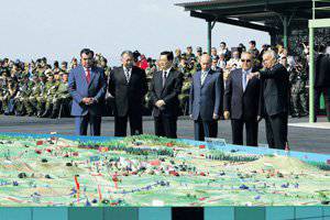
Layouts of the terrain on which the Peaceful Mission international command and staff exercises are held are always prepared by military topographers. Photo of the Office of the press service and information of the Ministry of Defense of the Russian Federation
At present, work has been organized on the modernization of the staff headquarters vehicle (AST), the main means of delivery of topographic and geodetic information to troops. It is planned to equip the AST with a software and hardware complex to provide the troops in the field with digital information about the terrain along with analog mapping materials. Also in the coming years, it is planned to equip topogeodesic military units with modern devices for the autonomous determination of azimuths of reference directions (gyrotheodolites) and instruments for determining the values of gravitational accelerations (gravimeters) with the highest characteristics in terms of accuracy and reliability.
Currently, within the framework of the state defense order, a number of research and development works are being carried out aimed at developing the system of topographic, geodetic and navigation support (TGNO) of the RF Armed Forces. In the process of creation are: a mobile multi-purpose topographic and geodesic complex, an aircraft aerial surveyor, software and hardware systems (software) for processing geospatial data. Their implementation will ensure the creation of hardware and software that meets modern information security requirements, ensuring the construction of a topographic, geodetic and navigation support system for the Armed Forces of the Russian Federation, as well as the required geo-information resources for use in automated control systems of the Armed Forces.
To solve scientific problems in the interests of developing and improving topogeodesic and navigation support for the Armed Forces of the Russian Federation for military science and technical support of development of topogeodesic equipment, technologies for the benefit of topographic service in the Armed Forces of the Russian Federation, there is a research center (topogeodesic and navigation support) of FGKU "27" Central Research Institute of the Ministry of Defense of the Russian Federation (SICTNT).
The main tasks of SIC TNC are scientific research in the areas of:
- Improving the methods of the Russian Armed Forces Civil Aviation;
- the creation and use of general and military GIS;
- the creation and modernization of mobile topographic tools;
- development of the theoretical foundations, methods and technologies for creating remote sensing (remote sensing of the Earth) based on aerospace photography for modern weapon systems;
- development of the theoretical foundations, tools and technologies for creating digital cartographic information about the terrain when creating digital topographic maps to foreign territories using photographs and remote sensing data obtained by space complexes;
- cartographic products in analog form;
- development and improvement of the theory, tools and methods of astronomic-geodetic support of the RF Armed Forces;
- creation and improvement of the initial geodetic base in the interests of the State Service for Civil Aviation with the use of space geodetic, navigation and other complexes and systems, development and improvement of methods for gravimetric support of the RF Armed Forces;
- improvement of methods and technologies for performing special geodetic works.
HUMAN POTENTIAL
I would like to touch upon the issue of training military topographers. The officers of the Topographic Service of the Armed Forces of the Russian Federation, as almost two centuries ago, are preparing one of the oldest military educational institutions in Russia - today it is the faculty of topographic and geodetic support and cartography of the AF Military Space Academy. Mozhaisky. This is the only unique military educational institution in the country that has been preparing highly professional military specialists in the fields of geodesy, topography and cartography for five years. Officers of the Topographic Service of the Armed Forces of the Russian Federation receive higher military education at the Military Training and Scientific Center of the Ground Forces “Combined Arms Academy of the Armed Forces of the Russian Federation”. In 2014, a number of top officer officers were recruited to the Combined-Arms Academy (Moscow) and 82 cadets to the Military Space Academy. A.F. Mozhaisky (St. Petersburg) to study at the faculty of topographic and geodetic software and cartography.
The training of junior specialists for a topographic service is organized on the basis of the department of training junior specialists of the military unit 73535 (Borovichi, Novgorod region). This year, the first intake of 60 cadets was made, training will start from December 15.
Also, for the topographic service of the Armed Forces of the Russian Federation, training in the training program for reserve officers is conducted at the military department at the Moscow State University of Geodesy and Cartography (MIIGAiK). In the 2014 year, recruited for training 120 people.
Pursuant to the provisions of the annual Presidential Address to the Federal Assembly of the Russian Federation of 12 December 2013, in terms of improving the system of military training of university students at the military department at MIIGAiK, students were trained in training programs for sergeants and reserve soldiers in the number of 29 students, training started from 20 September 2014 of the year .
Contract servicemen are now actively recruited into the Russian army, and the military topographic department of the General Staff of the RF Armed Forces is actively working to recruit sergeants and soldiers for military servicemen under contract military service.
To this end, held:
- conversations with servicemen undergoing military service for the purpose of further military service under the contract;
- Work in military commissariats, educational institutions and enterprises for the agitation of citizens in the reserve, on the issues of military service under the contract in topogeodetic military units.
In accordance with the parameters of the number established by the General Staff of the Armed Forces of the Russian Federation for directly subordinated topogeodesic military units, the ratio of military personnel under military service under contract in the positions of private and non-commissioned officers in relation to military servicemen in 2014 is 40% to 60%, and 2020 year is planned to reach the ratio 60% to 40%.
TESTED BY PRACTICE
I wanted to give special attention to the combat training of military topographers. Over the past two years, in connection with the development and introduction of new statutory documents for combat training, the intensity has indeed increased significantly. The topographic service of the Armed Forces of the Russian Federation under the direction of the Military Topographical Department of the General Staff of the Armed Forces of the Russian Federation over 2014 conducted more than 20 various exercises and training sessions.
In the current year, the military topographic department of the General Staff of the Armed Forces of the Russian Federation and its subordinate military authorities and military units carried out training in topogeodesic and navigational terms and took part in the Vostok-2014 SKSHU, Rubezh-2014 SKSHU and the Indestructible Brotherhood 2014 ”, SAKSHU“ Peace Mission-2014 ”, the joint Russian-Indian exercise“ Indra-2014 ”, the joint Russian-Belarusian exercise“ Slavic Commonwealth-2014 ”, the joint Russian-Mongolian exercise“ Selenga-2014 ”and a number of other joint exercises.
Directly under the direction of the Military Topographical Directorate of the General Staff of the Armed Forces of the Russian Federation, special tactical exercises on the Horizon site are held annually. The plan for the exercise is being developed as part of the overall design of the operational training of the Armed Forces for the academic year, taking into account the specifics of performing tasks for the Topographic Service of the Armed Forces of the Russian Federation and specifying special topographic, geodetic and cartographic works that are planned to be carried out during the preparation and conduct of the strategic level exercise. In addition to the staff of the topographic and geodetic military units of central subordination and the research center, more than 150 cadets from the faculty of topographic and geodetic support and cartography of the A.F. Mozhaisky and students completing training at the military department at the Moscow State University of Geodesy and Cartography (MIIGAiK). From 2015, it is planned that cadets of the training department (junior specialists) of the 47 expeditionary topogeodesic detachment will participate in this exercise as the final stage of their training.
In order to improve the level of training of personnel of topographic and geodetic military units and subunits, an annual field training competition is being planned and held among units and officers of the topographic service, which takes place in four stages: directly in the military unit, then in the topographic services of the armed forces of the Russian Federation and military districts, the Topographic Service of the Armed Forces of the Russian Federation and in general - in the Armed Forces. According to the results of the competition, the best officers of the topographic service are submitted for out-of-competition admission to the profile department of the General Military Academy of the Armed Forces of the Russian Federation. In order to further develop the Military Topographical Directorate of the General Staff of the Armed Forces of the Russian Federation, together with the topographic services of the armed forces of the CIS member states, the possibility of holding an international stage of competition in the framework of the field training of subunits and officers is being worked out.
Also, the Military Topographical Directorate of the General Staff of the Armed Forces of the Russian Federation, together with the military schools of the Russian Ministry of Defense, is working on a promising project to hold military topography knowledge and practical orientation in the Armed Forces.
I want to mention one of the most ambitious SKSHU "Vostok-2014", in which the military personnel of the Topographic Service of the Armed Forces of the Russian Federation took the most direct part.
The topographic and geodetic military units of the Eastern Military District, under the direction of the Main Technical Directorate of the General Staff and the topographic service of the military district headquarters, carried out tasks for the topographic and geodetic and navigation support of the forces (troops) involved in Vostok-2014. They also worked out special tasks in the interests of the plan of the exercise, in particular, in preparing for the publication and publication of both digital photographic materials and individual nomenclature sheets of analog cartographic materials for areas where the VVO troops perform tasks for the purpose, to provide the initial astronomical and geodetic data of military units and units of the types and types of troops of the military district, geodetic binding field airfield. To accomplish the tasks of the topographic and geodetic and navigation support of the troops (forces) during the Vostok-2014 exercise, about 150 people from the staff of topographic and geodetic military units and 30 units of special equipment took part.
In the course of Vostok-2014 SKSHU, at the control point of the topographic, geodetic and navigational support staff of the Eastern Military District, activities were carried out to plan and organize topographic, geodetic and navigational support for the use of force groups in the strategic direction, as well as measures for the practical implementation of special works by the subordinate topographic and military units in parts.
During the preparation and conduct of SKSHU, GIS "Integration" and GIS "Operator" were used to work out combat graphic documents. For the automation of command and control, the Bastion, Dozor, Sea-99 automated control systems and the Rokada operational environment editor were used.
On the whole, according to the results of the Vostok-2014 control center, the Topographic Service of the Eastern Military District headquarters fulfilled the tasks set by the management and was rated positively.
Information