Accurate air discharge
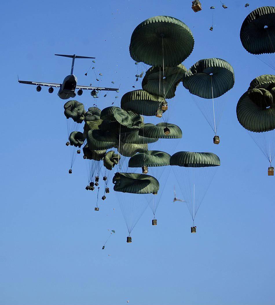
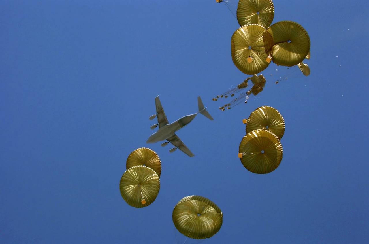
Transport C-17 GLOBEMASTER III delivers humanitarian aid to the outskirts of Port-au-Prince in Haiti on January 18 of 2010
This article describes the basic principles and data on testing of high-precision airborne systems of NATO countries, describes the navigation of the aircraft to the point of release, the control of the trajectory, as well as the general concept of discharged cargo, enabling them to land accurately. In addition, the article emphasizes the need for accurate discharge systems, and in it the reader becomes familiar with promising concepts of operations.
It is worth noting the current growing interest of NATO to accurate dropping. The NATO National Weapons Directorate Conference (NATO, CNAD) has set an accurate drop for special operations forces as NATO's eighth highest priority in the fight against terrorism.
Today, most of the drops are carried out by flying over the computed air release point of CARP (computed air release point), which is calculated on the basis of wind, system ballistics and aircraft speed. The ballistic table (based on the average ballistic characteristics of this parachute system) determines the CARP where the load is dropped. This average data is often based on a dataset that includes deviations up to standard deviation meters to 100. CARP is also often calculated using the average winds (for winds at heights and near the surface) and the assumptions about the constant profile (pattern) of air flow from the release point to the ground. Wind patterns are rarely constant from ground level to high altitudes; the amount of deviation depends on the influence of the terrain and the natural variables of the meteorological characteristics of wind currents, such as wind shear. Since most modern threats come from ground-based fire, a modern solution is to drop cargo at high altitudes and subsequent horizontal displacement, which allows the aircraft to be diverted from a dangerous route. Obviously, in this case, the influence of various air currents increases. In order to meet the requirements of airborne dropping (hereinafter aviabelling) from high altitudes and to prevent the delivered goods from entering the “wrong hands”, accurate airborne dropping at the NATO CNAD conference received high priority. Modern technology has made possible the implementation of many innovative methods of dropping. In order to reduce the impact of all variables that impede accurate ballistic dropping, systems are being developed not only to improve the accuracy of CARP calculations due to more accurate wind profiling, but also a system of handling the dropping load to the point of a predetermined impact with the ground regardless of changes in force and direction wind
Impact on the achievable accuracy of airborne drop systems
Variability is the enemy of accuracy. The less the process changes, the more accurate the process, and here air drop is no exception. There are many variables in the airborne process. Among them are uncontrolled parameters: weather, human factor, for example, the difference in cargo securing and crew actions / time calculations, perforation of individual parachutes, differences in the manufacture of parachutes, differences in the dynamics of the disclosure of individual and / or group parachutes and the effect of their wear and tear. All these and many other factors influence the achievable accuracy of any airborne system, ballistic or controlled. Some parameters can be partially controlled, such as airspeed, heading and altitude. But due to the special nature of the flight, even they can vary to some extent during most drops. Nonetheless, accurate airborne dropping has come a long way in recent years and has evolved rapidly since NATO members have invested and are investing heavily in technology and testing for accurate dropping. Numerous qualities of precision drop systems are currently being developed, and in the near future many other technologies are planned to be developed in this rapidly growing area of opportunity.
Navigation
The C-17 shown in the first photo of this article has automatic capabilities regarding the navigation part of the exact drop process. Accurate C-17 dropping is performed using CARP, HARP (high-altitude release point) or low-altitude parachute extraction system (LAPES) low-altitude parachute discharge system algorithms. In this process of automatic dropping, the ballistics, the calculations of the place of discharge, the signals to start dropping are taken into account, and the main data are recorded at the time of the reset.
When dropped at low altitudes, at which the parachute system is deployed when the cargo is dropped, CARP is applied. For high-altitude drops, HARP is activated. Note that the difference between CARP and HARP is in calculating the free fall trajectory when dropping from high altitudes.
The C-17 aircraft aircraft flight data base contains ballistic data of various types of cargo, for example, personnel, containers or equipment, as well as their corresponding parachutes. Computers allow you to update ballistic information and display it at any time. The database stores the parameters as input to the ballistic calculations performed by the on-board computer. Please note that C-17 allows you to save ballistic data not only for individuals and individual items of equipment / cargo, but also for a combination of people leaving the aircraft and their equipment / cargo.
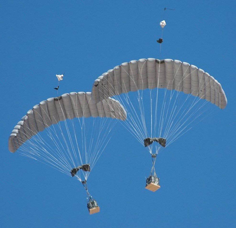
JPADS SHERPA has been operating in Iraq since August 2004, when the Natick Soldier Center deployed two systems in the Marine Corps. The previous version of JPADS, for example Sherpa 1200s (pictured), has a limitation on the carrying capacity of about 1200 pounds, while the specialist rigging usually form sets weighing about 2200 pounds
The 2200 class-controlled cargo of a combined JPADS (Joint Precision Airdrop System) precision aero-throwing system in flight during the first combat surge. A joint team consisting of army, air force and contractor representatives recently adjusted the accuracy of this option for JPADS
Air flow
After the dumped load is released, the air begins to affect the direction of movement and the time of the fall. The computer onboard the C-17 calculates the airflow using data from various onboard sensors of flight speed, pressure and temperature, as well as navigation sensors. Wind data can also be entered manually using information from the actual drop area (RS) or from the weather forecast. Each data type has its advantages and disadvantages. The wind sensors are very accurate, but they cannot show weather conditions over the PC, since the aircraft cannot fly from the ground to a given height above the RS. The wind on the ground is usually not the same as the air flow at a height, especially at high altitude. Predicted winds are a prediction and they do not reflect the speeds and directions of flows at different altitudes. Actual flow profiles usually do not depend linearly on height. If the actual wind profile is not known and is not entered in the flight computer, by default, the CARP linear wind profile assumption is added to the CARP calculation errors. After these calculations have been performed (or the data has been entered), their results are recorded in the database of airborne drops for use in further CARP or HARP calculations based on average actual air flows. Winds are not used for dropping with LAPES technology, since the plane drops cargo just above the ground at the desired point of impact. The computer in the C-17 plane calculates the net deviation values during wind drift in the direction of the course and perpendicular to it for conducting airborne drops in the CARP and HARP modes.
Wind systems
In the radio probe, a GPS unit with a transmitter is used. It is carried by the probe, which is produced near the drop area before release. The obtained location data is analyzed to obtain a wind profile. This profile can be used by the drop manager to adjust CARP.
The Air Force control laboratories for sensor systems at Wright-Patterson airbase developed a high-energy two-micron Doppler transceiver LIDAR (Light Detection and Ranging - infrared laser locator) on carbon dioxide with an 10,6 micron laser for measuring air flow at high altitude. It was created, firstly, to provide real-time 3D maps of wind fields between the aircraft and the ground, and, secondly, to significantly improve the accuracy of dropping from great heights. It makes accurate measurements with a typical error of less than one meter per second. The advantages of LIDAR are the following: provides a complete 3D wind field measurement; provides real-time data flow; is on the aircraft; and also his secrecy. Disadvantages: cost; useful range is limited by atmospheric noise; and requires minor modification of the aircraft.
Due to the fact that deviations in time and location data can affect wind detection, especially at low altitudes, testers should use GPS DROPSONDE devices to measure winds in the drop area as close as possible to the test time. DROPSONDE (or more fully, DROPWINDSONDE) is a compact tool (a long thin tube) that is dropped from an aircraft. Airflows are set using the GPS receiver in DROPSONDE, which tracks the relative Doppler frequency from the radio frequency carrier of the GPS satellite signals. These Doppler frequencies are digitized and sent to the on-board information system. DROPSONDE can be deployed before the arrival of a cargo plane from another aircraft, for example, even from a jet fighter.
Parachute
A parachute can be a round parachute, a paraglider (parachuting wing), or both. In the JPADS system (see below), for example, either a paraglider or a paraglider / round parachute is mainly used for braking cargo during descent. A “guided” parachute provides JPADS flight direction. Other parachutes in the common system are often also used in the final descent section. Parachute control lines go to the AGU (airborne guidance unit) air guidance device to shape the parachute / paraglider to control the course. One of the main differences between the categories of braking technology, that is, the types of parachute, is the horizontal achievable offset that each type of system can provide. In the most general terms, displacement is often measured as the lift / drag aerodynamic quality (lift-to-drag ratio) of the system “at zero winds”. It is clear that it is much more difficult to calculate the achievable displacement without accurate knowledge of the many parameters affecting the deviation. These parameters include airflows that the system encounters (winds can help or interfere with deviations), the total available vertical distance for dropping and the height the system needs for full disclosure and planning, as well as the height that the system needs for preparation before crashing to the ground. In general, paragliders provide L / D values in the range from 3 to 1, hybrid systems (i.e. high-winged paragliders for controlled flight, which near the impact with the ground turn into ballistic, provided by round domes) give L / D in the 2 range / 2,5 - 1, while traditional round parachutes, controlled by sliding, have L / D in the 0,4 / 1,0 - 1 range.
There are numerous concepts and systems that have much higher L / D ratios. Many of them require structurally rigid guide edges or "wings" that "unfold" during deployment. As a rule, these systems are more complex and expensive to use in airborne dropping, and they also tend to fill the entire available volume in the cargo hold. On the other hand, more traditional parachute systems exceed the total weight limits for the cargo hold.
Also, for parachute systems for dropping cargo from a high altitude and delaying the opening of a parachute to a low altitude HALO (high-altitude low opening) can be considered for high-precision aero-throwing. These systems are two-step. The first stage, in general, is a small uncontrolled parachute system that quickly lowers the load over most of the trajectory in height. The second stage is a large parachute, which opens “close” to the ground for final contact with the ground. In general, such HALO systems are much cheaper than controlled drop-off systems, and they are not so accurate, and if several cargo sets are dropped at the same time, they will cause this cargo to “scatter”. This spread will be greater than the speed of the aircraft, multiplied by the time of disclosure of all systems (often a kilometer distance).
Existing and proposed systems
The landing phase is particularly affected by the ballistic trajectory of the parachute system, the effect of the winds on this trajectory, and any ability to control the dome. Trajectories are evaluated and provided to aircraft manufacturers for entry into an on-board computer for calculating CARP.
However, in order to reduce the errors of the ballistic trajectory, new models are being developed. Many NATO member countries are investing in precision drop systems / technologies, and even more countries would like to start investing in order to meet NATO requirements and national standards for accurate cargo dropping.
Joint Precision Air Drop System Joint JPADS System
Precise dropping does not allow “to have one system that is suitable for everything”, since the weight of the load, the difference in height, accuracy, and many other requirements vary considerably. For example, the US Department of Defense is investing in numerous initiatives as part of a program known as the Joint Precision Air Drop System (JPADS). JPADS is a controlled, high-precision aero-drop system that greatly improves accuracy (and reduces dispersion).
After dropping into high altitude, JPADS uses GPS and guidance, navigation and control systems for its accurate flight to a designated point on the ground. Its gliding parachute with self-inflating shell allows you to land at a considerable distance from the drop point, while pointing this system allows you to perform high-altitude drops to one or multiple points simultaneously with 50 - 75 meters accuracy.
Several US allies showed interest in JPADS systems, while others are developing their own systems. All JPADS products from the same manufacturer share a common software platform and user interface in stand-alone pointing devices and a task scheduler.
HDT Airborne Systems offers systems ranging from MICROFLY (45 - 315 kg) to FIREFLY (225 - 1000 kg) and DRAGONFLY (2200 - 4500 kg). FIREFLY won the American JPADS 2K / Increment I contest, and DRAGONFLY won the 10000 pounds class. In addition to these systems, MEGAFLY (9000 - 13500 kg) set the world record for the largest self-filling dome ever to take to the air, until this record was broken in 2008 with an even larger GIGAFLY system with a load of 40000 pounds. Earlier in the year, it was announced that HDT Airborne Systems had won a fixed-price contract with 11,6 million dollars for JPAD's 391 system. Contract work was carried out in the city of Pennsokene and ended in December 2011 of the year.
MMIST offers the systems SHERPA 250 (46 - 120 kg), SHERPA 600 (120 - 270 kg), SHERPA 1200 (270 - 550 kg) and SHERPA 2200 (550 - 1000 kg). These systems were purchased by the United States and are used by US marines and several NATO countries.
Strong Enterprises offers SCREAMER 2K in the 2000 class of pounds and Screamer 10K in the 10000 class of pounds. She has worked with Natick Soldier Systems Center on JPADS since 1999. In 2007, the company had 50 of its 2K SCREAMER systems operating on a regular basis in Afghanistan, and the 101 system was ordered and delivered by January 2008.
Boeing's Argon ST subsidiary received a contract with no agreed delivery date and an unspecified amount of 45 million dollars worth for the purchase, testing, delivery, training and logistics of ultra-light JPADS Ultra Light Weight (JPADS-ULW). JPADS-ULW is an aircraft-driven dome system that is capable of delivering safely and effectively loads of 250 total weight - 699 pounds from heights to 24500 feet above sea level. Work will be carried out in Smithfield and is expected to be completed in March 2016.
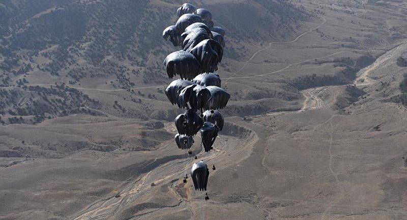
Forty bales of humanitarian aid are dumped from C-17 using the JPADS system in Afghanistan
S-17 dumps coalition forces in Afghanistan using improved system aviation deliveries with installed LAPS software from NOAA
SHERPA
SHERPA is a delivery system consisting of commercially available components manufactured by the Canadian company MMIST. The system consists of a programmable small parachute that deploys a large dome, a parachute control unit and a remote control.
The system is capable of delivering 400 - 2200 pounds of cargo using 3 – 4 paragliders of various sizes and AGU air guidance devices. Before the flight, a task can be planned for SHERPA by entering the coordinates of the intended landing point, available wind data and cargo characteristics.
The SHERPA MP software uses the data to create a task file and calculate CARP in the drop area. After dropping from the aircraft, the exhaust parachute of the Sherpa system - a small round stabilizing parachute - is deployed with an exhaust line. The exhaust parachute is attached to the exhaust trigger lock, which can be programmed to operate at a predetermined time after the parachute opens.
SCREAMER
The SCREAMER concept was developed by the American company Strong Enterprises and first introduced at the beginning of 1999. The SCREAMER system is a hybrid JPADS, which uses an exhaust parachute for guided flight along the entire vertical descent, and also uses conventional, round unmanaged domes for the final phase of the flight. Two options are available, each with the same AGU. The first system with 500 carrying capacity is 2200 pounds, the second with 5000 carrying capacity is 10000 pounds.
SCREAMER AGU is supplied by Robotek Engineering. In the SCREAMER system with a lifting capacity of 500 - 2200 pounds, a self-inflating parachute with an area of 220 square is used. ft. as exhaust with load up to 10 lb / sq. foot; the system is able to pass through most of the harshest wind flows at high speed. The SCREAMER RAD is controlled either from a ground station or (for military applications) during the initial phase of the flight using AGUs weighing 45 pounds.
Paragliding system DRAGONLY with a load capacity of 10000 pounds
The preferred system for the American program for the joint system of accurate air delivery with a load capacity of 10000 pounds under the designation JPADS 10k was DRAGONFLY from HDT Airborne Systems, which is a fully autonomous GPS-guided delivery system. Distinguished by a braking parachute with an elliptical dome, she has repeatedly demonstrated the ability to land within 150 radius from the intended meeting point. Using data only at the point of landing, the AGU (Airborne Guidance Unit) device calculates its 4 position once per second and constantly adjusts its flight algorithm to ensure maximum accuracy. The system has a slip ratio of 3.75: 1 to ensure maximum displacement and a unique modular system that allows you to charge the AGU during the folding of the dome, thereby reducing the cycle time between drops to less than 4 hours. As standard, it comes with a functional Mission Planner planner from HDT Airborne Systems, which is capable of performing simulated tasks in a virtual operating space using mapping programs. Dragonfly is also compatible with the existing JPADS Mission Planner (JPADS MP). The system can be pulled out immediately after leaving the aircraft or gravitationally falling using a traditional G-11 exhaust kit with one standard exhaust sling.
The DRAGONFLY system was developed by the JPADS ACTD group of the US Army's Natick Soldier Center in collaboration with Para-Flite, the developer of the braking system; Warrick & Associates, Inc., developer of AGU; Robotek Engineering, avionics supplier; and Draper Laboratory, software developer for GN&C. The program began in 2003 and flight tests of the integrated system began in mid-2004.
Available system AGAS (Affordable Guided Airdrop System)
Capewell and Vertigo AGAS is an example of JPADS with a controlled round parachute. AGAS is a joint development of the contractor and the US government that began in the 1999 year. It uses two actuators in the AGU device, which line up between the parachute and the cargo container and which use the opposite free ends of the parachute to control the system (i.e., the parachute system slip). Four free end tillers can be controlled individually or in pairs, providing eight directions of control. The system needs an accurate profile of the winds with which it will meet over the discharge area. Before dropping, these profiles are loaded into the AGU on-board flight computer in the form of a planned trajectory along which the system “follows” during descent. The AGAS system is able to adjust its location by means of lines all the way to the meeting point with the ground.
ONYX
Atair Aerospace developed the ONYX system under the contract of the American Army SBIR Phase I for 75-pounds cargo and was scaled by ONYX in order to achieve a load capacity of 2200 pounds. The ONYX 75-pound parachute system divides guidance and a soft landing between two parachutes, with a self-inflating guidance shell and a ballistic round parachute opening above the meeting point. The “herd” algorithm has recently been included in the ONYX system, which allows for in-flight interaction between systems during mass landing.
Small Paragliding Autonomous Delivery System SPADES (Small Parafoil Autonomous Delivery System)
SPADES is being developed by a Dutch company in collaboration with the national aerospace laboratory from Amsterdam with the support of the parachute manufacturer of the French company Aerazur. The SPADES system is designed for the delivery of 100 - 200 kg goods.
The system consists of a paragliding parachute with an area of 35 m2, a control unit with an on-board computer and a cargo container. It can be dropped from a height of 30000 feet at a distance of removal to 50 km. It is autonomously controlled by GPS. Accuracy is 100 meters when dropping 30000 feet from a height. Parachute SPADES with an area of 46 m2 delivers with the same accuracy loads of mass 120 - 250 kg.
Free Fall Navigation Systems
Several companies are developing personal navigation aids on airborne releases. They are mainly designed for high-altitude drops with an immediate opening of a HAHO parachute (high-altitude high opening). HAHO is an overshoot occurring at high altitude with a parachute system deployed when leaving the aircraft. As expected, these free-fall navigation systems will be able to direct special forces to the desired landing points under bad weather conditions and will maximize the distance from the drop point. This minimizes the risk of detecting an invading unit, as well as a threat to the delivery aircraft.
The free-fall navigation system for the Marine Corps / Coast Guard went through three stages of prototyping, all stages with a direct order from the US Marine Corps. The current configuration is as follows: fully integrated civilian GPS with antenna, AGU and aerodynamic display attached to a paratrooper helmet (manufactured by Gentex Helmet Systems).
EADS PARAFINDER provides the military parachutist in free fall with improved horizontal and vertical displacement (deviation) (that is, displacement from the landing point of the dropped load) in order to achieve its main goal or up to three alternative targets in any surrounding conditions. A paratrooper puts a helmet-mounted GPS antenna and processor unit on the belt or pocket; The antenna provides information on the parachutist helmet display. The helmet display shows the paratrooper the current direction and desired course, which is based on the landing plan (i.e., air flow, drop point, etc.), current altitude and location. The display also shows the recommended control signals showing which line to pull in order to head to the three-dimensional point in the sky along the ballistic wind line generated by the task planner. The system has a HALO mode, which directs the paratrooper to the landing point. The system is also used as a navigation tool for a landed parachutist to direct him to the gathering point of the group. It is also designed to be used with limited visibility and to maximize the distance from the jump point to the touchdown point. Limited visibility may be due to bad weather, dense vegetation or during night jumps.
Conclusions
Beginning in 2001, high-precision airborne bombardment developed rapidly and is likely to become more common in military operations in the foreseeable future. Accurate dropping is a high priority short term demand in the fight against terrorism and a long term demand for LTCR within NATO. Investments in these technologies / systems are growing in NATO countries. The need for accurate dropping is understandable: we must protect our crews and transport aircraft, giving them the opportunity to avoid ground threats and at the same time deliver supplies, armaments and personnel across the widely distributed and rapidly changing battlefield.
Improved aircraft navigation using GPS has increased the accuracy of drops, and weather forecasting and direct measurement methods provide significantly more accurate and high-quality weather information to crews and combat planning systems. The future of accurate dropping will be based on controlled, deployable from high altitudes, GPS guided, efficient aircraft dropping systems that will use advanced task scheduling capabilities and will be able to provide accurate logistics for a soldier at an affordable price. The ability to deliver supplies and weapons to any destination, at any time and in almost all weather conditions will become a reality for NATO in the very near future. Some of the accessible and rapidly developing national systems, including those described in this article (and similar ones), are currently being used in really small quantities. In the coming years, we can expect further improvements, improvements and upgrades of these systems, since the importance of delivering materials at any time and place is critical for all military operations.
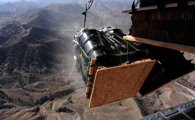

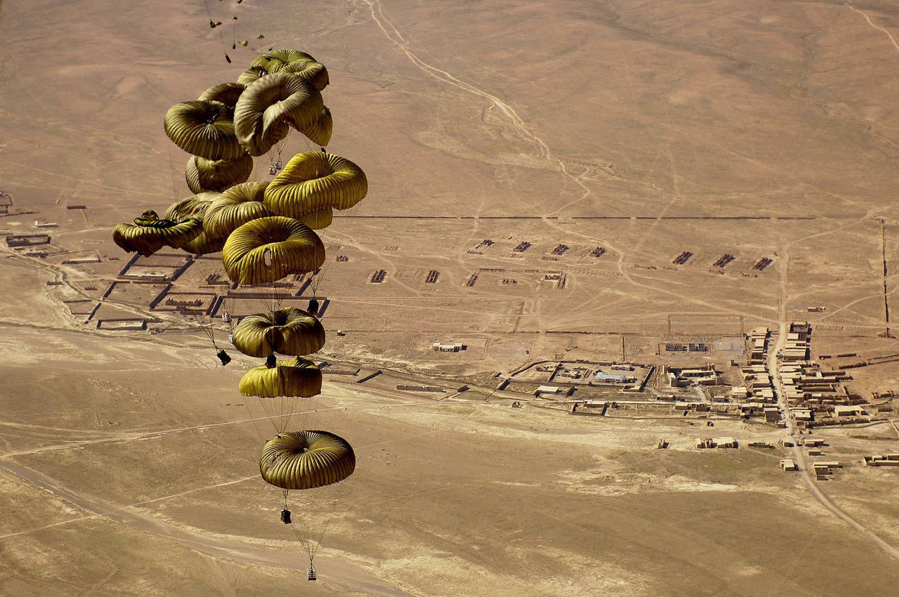
Riggers of the US Army from Fort Bragg assemble fuel containers before discharge during Operation Enduring Freedom. Then forty containers of fuel fly out of the cargo compartment of the GLOBEMASTER III.
Materials used:
Military Technology 12 / 2013
www.mmist.ca
www.strongparachutes.com
www.atair.com
Information