There is no way out. On the geographical closeness of the oceans for the Russian Navy
A bit of geography for beginners.
Periodically in discussions of issues related to the underwater warfare, or, as it was recently, with atomic supertorpedo "Poseidon", some citizens are beginning to speak on the theme of “going out to the ocean”, that finding a submarine or “Poseidon” in the ocean is unrealistic because of its size and the like. Sometimes the same things are expressed about surface ships, about the prospects for their deployment in a particular area of the world ocean during an ongoing war.
Such ideas are the result of so-called “cognitive distortion”. The man in the street believes that the ocean is big, you can “go out” into it. And this is despite the fact that most people who write and approve such things perfectly imagine a map of the world and its individual regions. But “cognitive distortion” puts this knowledge behind the brackets, and it exists separately from the idea of “going out” into the ocean.
It makes sense to conduct a sort of educational program: repeat what everyone seems to know and so, but they don’t remember about it. Repeat so that recalled.
Those who are “at odds” with geography or served in officer positions in the Navy will not find anything new in this article and can safely finish reading it at this moment. Those who believe in “going out to the ocean” should read to the end.
Because with the outputs in the oceans, our Navy is not very good. Rather, bad. Or rather, there are almost none. So it will be closest to reality.
But first things first.
The division of Russian sea theaters has always been its strength and weakness at the same time. By force, because in the preatomic epoch, no adversary could count on being able to smash the whole fleet at once. In addition, during a geographically limited war, one of the battling fleets could come up with reinforcements that were based so far that they were, for the time, invulnerable to the enemy.
The weakness was that any single fleet was almost always weaker than its rivals, after the end of the sailing era for sure. And formally a large payroll fleet could not keep the enemy from attack, in the conditions of his numerical superiority - an example of which is the same Russo-Japanese war. At the same time, the transfer of reinforcements was fraught with the fact that the forces of the fleet would be broken up in parts - which, again, the Japanese showed us in 1905. But the division of the fleets was and remains only part of the geographical problem of our Navy. The second and more important problem is that our fleets are cut off from the oceans and, in fact, do not have access to it. In the event of a major war, this will inevitably affect its character in the most serious way. For example, by the fact that we can’t transfer reinforcements from the theater of operations to the theater of operations, and we won’t be able to go out into the open and fight. And much more we can’t.
Consider the situation for each of the fleets.
The Northern Fleet is based in the Arctic Ocean. In the arctic. In peacetime, ships and submarines of the Northern Fleet go into the oceans without difficulty, and perform tasks at any point.
And in the military? We look at the map.

Red arrows are those directions in which, in theory, after heavy battles in the sea and in the air, as well as on land (!), Surface ships and submarines can also pass. For surface ships, passage for at least a few months a year is considered possible. Blue arrows indicate the directions in which submarines could theoretically pass, and surface ships either cannot or even can literally one month a year, with great risk, even in spite of icebreaking support. That is, with an unacceptably high risk due to ice conditions.
As can be easily seen from the map, in fact, the Northern Fleet is located in a geographically closed area - all exits from it are controlled by the Anglo-Saxons either directly or by the hands of NATO allies and together with them. At the same time, such narrow spots as the Bering Strait, the Robson Strait (between Canada and Greenland) or the straits between the islands of the Canadian Arctic Archipelago are small enough in width to be mined very quickly. And even without mining, spills of hundreds of kilometers wide can control anti-submarine forces consisting of a very small number of ships and submarines, and in addition, all these narrownesses are controlled aviation.
What do you need to lead ships through the Bering Strait during the war with NATO? At a minimum, establish air supremacy over a significant part of Alaska, and hold it long enough, despite the fact that we have one air base for the entire region with a less significant infrastructure - Anadyr, and another concrete runway in the village of Providence - and this on an area about the size of Ukraine. Almost unsolvable task.
The only exception is the main “road” of our submarines and ships “to the world” - the Faro-Icelandic frontier (three red arrows on the map in the left part).
It was here that NATO and the United States planned to intercept and destroy our submarines on this line. From the northern part of Britain, through the Shetland and Faroe Islands, to Iceland and then Greenland, the West actively created during the Cold War, and now began to revive the most powerful anti-paradigm line, based on the air base in Iceland, and airfields in Britain, on which a large anti-submarine can be deployed. aviation, as well as the Second Fleet of the United States Navy, and the Royal Navy of Great Britain, and the Norwegian Armed Forces, who together with him must first give our Northern Fleet a fight in the Norwegian Sea, and then, ing on the result, or stop us in the Faroe-Iceland abroad through mass mining, air strikes and attack surface and submarine forces, or go to "kill the bear" in the Barents and White seas. Given the balance of power, the second option today is much more realistic.
One way or another, it is worth noting that the Northern Fleet is located on a geographically isolated theater of operations, from which there are only a few exits, of which only two can really be used, and having won in a fierce battle with many times superior enemy forces. But rather from these directions on the theater will go the enemy himself.
Inside the theater there are practically no significant targets located in the United States. That is, assuming that the same "Poseidon" will be released here somewhere in free swimming, it is necessary to recognize that there are simply no goals for it.
The situation is similar in the Pacific. When basing our ships in Primorye, for them there are several exits to the World Ocean - the Tsushima Strait, the Sangar Strait and several Kuril Straits.
At the same time, the Strait of Sangar passes conditionally speaking “through Japan” and ships and submarines can be carried through it either with the consent of Japan, or by capturing Hokkaido, the northern part of Honshu, and destroying all Japanese aviation. And faster than a number of Americans draw. To go through Tsushima is even more difficult - it is necessary to neutralize Japan completely, and to achieve agreement on the passage of the second ally of the Americans - South Korea. Moreover, essential American forces will also be deployed faster than the theaters.
Given the fact that, as a rule, they are always there, the task looks absolutely unsolvable, especially with our existing forces.
Remains exit through the Kuril Straits.
We look at another map.
The arrows indicate the direction of entry of our SSBNs from Kamchatka to the Sea of Okhotsk. In places on the surface because of shallow depths. The exit of surface ships through the Kuril chain will be carried out by the same routes, just the other way. It is not difficult to see that the US needs to take control of just a few straits, and our fleet will be locked up in the Sea of Okhotsk. Taking control over the Americans, with their deadly effective submarines and the ability to protect their deployment areas from our aircraft, the PLO (very weak and small) does not look fiction.
We state - the Pacific Fleet (with one exception, about which a little later) is locked even more reliably than the Northern.
The remaining two fleets, theoretically capable of operating in the Far Sea zone - the Black Sea and Baltic, are generally located in almost inland seas, communicating with the world's oceans through a single “window” - in the Baltic through the Danish Straits, completely under the control of NATO, and on the Black Sea - through the Bosphorus and the Dardanelles, which are also controlled by NATO. In fact, in order not to let the enemy enter into the Baltic Sea and the Black Sea large sea forces, the Russian Federation, in the event of war, would have to occupy Denmark and at least part of Turkey, which, given the current state of the Russian Armed Forces, we have allies (or rather, the absence of Allies), controlled by the merchant fleet and landing forces, is unrealistic.
In the case of a hypothetical neutrality of Turkey, our fleet is still trapped out of the Black Sea, it gets into the Mediterranean, from which again only two exits - Gibraltar (under NATO control) and Suez, alongside which is militarily powerful pro-Western Israel.
Conclusion: the Russian fleet is able to act in the World Ocean only in peacetime, while in the war all those communications that it uses to enter the World Ocean pass through narrowness, which are either now completely controlled by the enemy (and to increase control over which the enemy has simply fantastic powers, both in quantity and quality), or they can easily be brought under control.
This fact is well known to the Anglo-Saxons. They built such a security system for centuries, seizing control over all the narrows and important straits (recall the seizure of Gibraltar, for example), and this control now gives them the ability to control the ocean, makes it possible for other countries to be cut off from access to the oceans, need.
An exception that does not fall under these restrictions is Kamchatka. It is there, in the Avacha Bay, that is our only point from which our ships and submarines enter the World Ocean immediately, bypassing the narrowness and straits. It is not difficult to guess that the US Navy is incredibly tightly controlling this harbor, tracking the movement of any ships from and into it, and especially submarines. It must be said that in carrying out powerful and provocative pressure on the Soviet Navy at the end of the 80 of the last century, the Americans largely neutralized the potential of Kamchatka - at least, for decades to take out SSBNs to combat patrols in the open ocean areas of the Navy, and not just like that. In addition, from a purely military point of view, Kamchatka is very vulnerable - should the Americans land a landing on it, it will be unrealistic to recapture it, for this we do not have a fleet, no ground communications, or an airfield network (for example, for airborne forces) of the necessary scale. Supplies by land Kamchatka can not be obtained, reinforcements by land - too. In fact, it is an isolated region, which in the event of war is simply impossible to protect.
Our fleet is locked, albeit within very large areas, but still locked. And there will be no way out of these locked areas in the event of war. This, among other things, means that we either have to accept the transfer of initiative to the enemy, that is, he can enter our closed theaters and leave them at will, as he controls the entrances and exits, or, alternatively, we must be prepared to conduct offensive operations conducted at such a pace that the enemy simply does not have time to react to them, the purpose of which would be either to intercept control over narrowness or to deprive the enemy of the possibility to exercise such control, in any way possible, yuchaya most radical.
This is a fundamental point.
At the same time, in the case of adopting a passive defensive strategy, it is necessary to clearly understand that it means not just the numerical superiority of the enemy over us in each of the theaters, but the absolute, overwhelming numerical superiority fraught with very fast loss of territories (the same Kamchatka and Kuriles), even temporary. And for offensive action, offensive forces are needed. And the sooner we understand this, the better.
By the way, we are not alone. Let's see how Americans see the "containment" of China.
So, "island chains" are barriers to Chinese influence.

It is with these “defensive” lines, as well as its ability to “plug” the Malacca Strait from the Indian Ocean, the US plans to “plug” China where it is now, stopping Chinese expansion by force, if necessary. The Anglo-Saxons are masters of such affairs, they deal with marine theaters as a grandmaster with a chessboard. And, as you can see, the Chinese, too, is not all easy with access to the ocean. How do they react to it? They build offensive forces, of course. And this is a much smarter reaction than ours, which is the complete absence of reaction in general.
However, with a population that, while imagining a map of the world, simultaneously believes in some opportunities to “go to the ocean” (which was repeatedly voiced at least in discussions about the Poseidon torpedo), another would be surprising.
We can only be glad that we live in peacetime, when all these factors are only potentially. Let us hope that it will remain so, because with the existing approaches to the development of Russia's sea power, we can only hope. Unlike the same Chinese.

Periodically in discussions of issues related to the underwater warfare, or, as it was recently, with atomic supertorpedo "Poseidon", some citizens are beginning to speak on the theme of “going out to the ocean”, that finding a submarine or “Poseidon” in the ocean is unrealistic because of its size and the like. Sometimes the same things are expressed about surface ships, about the prospects for their deployment in a particular area of the world ocean during an ongoing war.
Such ideas are the result of so-called “cognitive distortion”. The man in the street believes that the ocean is big, you can “go out” into it. And this is despite the fact that most people who write and approve such things perfectly imagine a map of the world and its individual regions. But “cognitive distortion” puts this knowledge behind the brackets, and it exists separately from the idea of “going out” into the ocean.
It makes sense to conduct a sort of educational program: repeat what everyone seems to know and so, but they don’t remember about it. Repeat so that recalled.
Those who are “at odds” with geography or served in officer positions in the Navy will not find anything new in this article and can safely finish reading it at this moment. Those who believe in “going out to the ocean” should read to the end.
Because with the outputs in the oceans, our Navy is not very good. Rather, bad. Or rather, there are almost none. So it will be closest to reality.
But first things first.
The division of Russian sea theaters has always been its strength and weakness at the same time. By force, because in the preatomic epoch, no adversary could count on being able to smash the whole fleet at once. In addition, during a geographically limited war, one of the battling fleets could come up with reinforcements that were based so far that they were, for the time, invulnerable to the enemy.
The weakness was that any single fleet was almost always weaker than its rivals, after the end of the sailing era for sure. And formally a large payroll fleet could not keep the enemy from attack, in the conditions of his numerical superiority - an example of which is the same Russo-Japanese war. At the same time, the transfer of reinforcements was fraught with the fact that the forces of the fleet would be broken up in parts - which, again, the Japanese showed us in 1905. But the division of the fleets was and remains only part of the geographical problem of our Navy. The second and more important problem is that our fleets are cut off from the oceans and, in fact, do not have access to it. In the event of a major war, this will inevitably affect its character in the most serious way. For example, by the fact that we can’t transfer reinforcements from the theater of operations to the theater of operations, and we won’t be able to go out into the open and fight. And much more we can’t.
Consider the situation for each of the fleets.
The Northern Fleet is based in the Arctic Ocean. In the arctic. In peacetime, ships and submarines of the Northern Fleet go into the oceans without difficulty, and perform tasks at any point.
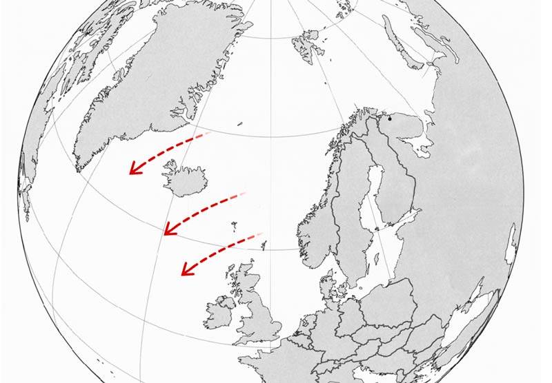
And in the military? We look at the map.
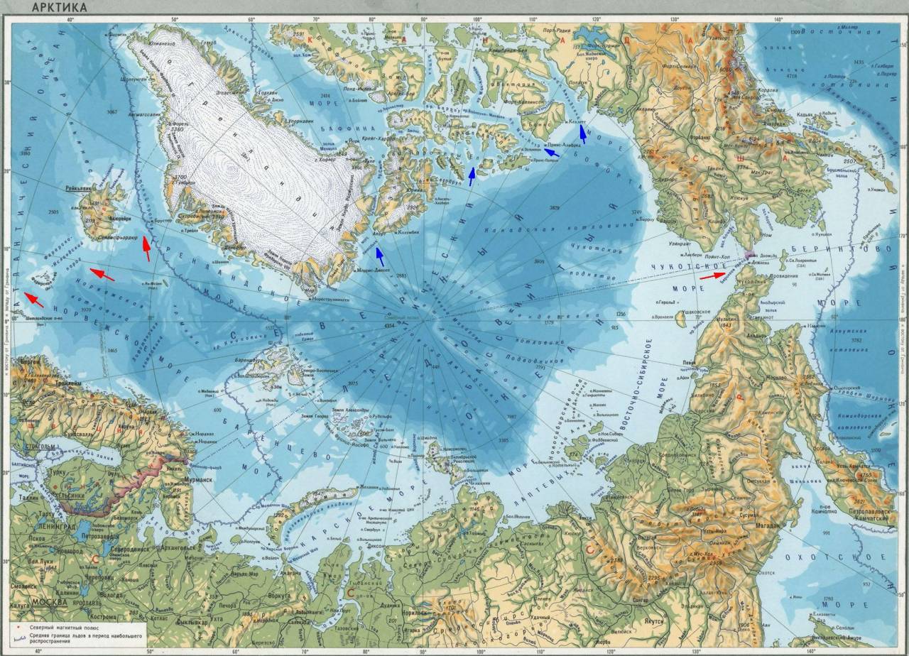
Red arrows are those directions in which, in theory, after heavy battles in the sea and in the air, as well as on land (!), Surface ships and submarines can also pass. For surface ships, passage for at least a few months a year is considered possible. Blue arrows indicate the directions in which submarines could theoretically pass, and surface ships either cannot or even can literally one month a year, with great risk, even in spite of icebreaking support. That is, with an unacceptably high risk due to ice conditions.
As can be easily seen from the map, in fact, the Northern Fleet is located in a geographically closed area - all exits from it are controlled by the Anglo-Saxons either directly or by the hands of NATO allies and together with them. At the same time, such narrow spots as the Bering Strait, the Robson Strait (between Canada and Greenland) or the straits between the islands of the Canadian Arctic Archipelago are small enough in width to be mined very quickly. And even without mining, spills of hundreds of kilometers wide can control anti-submarine forces consisting of a very small number of ships and submarines, and in addition, all these narrownesses are controlled aviation.
What do you need to lead ships through the Bering Strait during the war with NATO? At a minimum, establish air supremacy over a significant part of Alaska, and hold it long enough, despite the fact that we have one air base for the entire region with a less significant infrastructure - Anadyr, and another concrete runway in the village of Providence - and this on an area about the size of Ukraine. Almost unsolvable task.
The only exception is the main “road” of our submarines and ships “to the world” - the Faro-Icelandic frontier (three red arrows on the map in the left part).
It was here that NATO and the United States planned to intercept and destroy our submarines on this line. From the northern part of Britain, through the Shetland and Faroe Islands, to Iceland and then Greenland, the West actively created during the Cold War, and now began to revive the most powerful anti-paradigm line, based on the air base in Iceland, and airfields in Britain, on which a large anti-submarine can be deployed. aviation, as well as the Second Fleet of the United States Navy, and the Royal Navy of Great Britain, and the Norwegian Armed Forces, who together with him must first give our Northern Fleet a fight in the Norwegian Sea, and then, ing on the result, or stop us in the Faroe-Iceland abroad through mass mining, air strikes and attack surface and submarine forces, or go to "kill the bear" in the Barents and White seas. Given the balance of power, the second option today is much more realistic.
One way or another, it is worth noting that the Northern Fleet is located on a geographically isolated theater of operations, from which there are only a few exits, of which only two can really be used, and having won in a fierce battle with many times superior enemy forces. But rather from these directions on the theater will go the enemy himself.
Inside the theater there are practically no significant targets located in the United States. That is, assuming that the same "Poseidon" will be released here somewhere in free swimming, it is necessary to recognize that there are simply no goals for it.
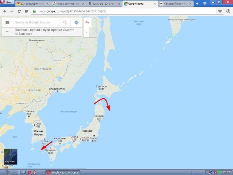
The situation is similar in the Pacific. When basing our ships in Primorye, for them there are several exits to the World Ocean - the Tsushima Strait, the Sangar Strait and several Kuril Straits.
At the same time, the Strait of Sangar passes conditionally speaking “through Japan” and ships and submarines can be carried through it either with the consent of Japan, or by capturing Hokkaido, the northern part of Honshu, and destroying all Japanese aviation. And faster than a number of Americans draw. To go through Tsushima is even more difficult - it is necessary to neutralize Japan completely, and to achieve agreement on the passage of the second ally of the Americans - South Korea. Moreover, essential American forces will also be deployed faster than the theaters.
Given the fact that, as a rule, they are always there, the task looks absolutely unsolvable, especially with our existing forces.
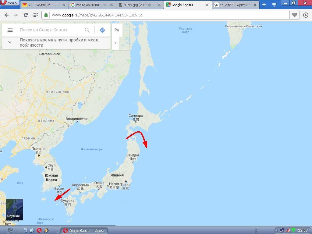
Remains exit through the Kuril Straits.
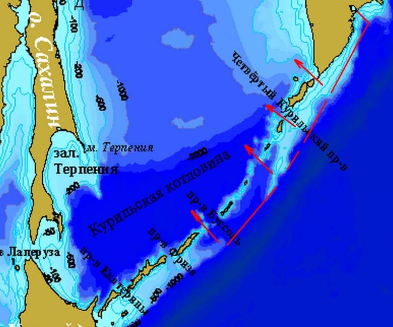
We look at another map.

The arrows indicate the direction of entry of our SSBNs from Kamchatka to the Sea of Okhotsk. In places on the surface because of shallow depths. The exit of surface ships through the Kuril chain will be carried out by the same routes, just the other way. It is not difficult to see that the US needs to take control of just a few straits, and our fleet will be locked up in the Sea of Okhotsk. Taking control over the Americans, with their deadly effective submarines and the ability to protect their deployment areas from our aircraft, the PLO (very weak and small) does not look fiction.
We state - the Pacific Fleet (with one exception, about which a little later) is locked even more reliably than the Northern.
The remaining two fleets, theoretically capable of operating in the Far Sea zone - the Black Sea and Baltic, are generally located in almost inland seas, communicating with the world's oceans through a single “window” - in the Baltic through the Danish Straits, completely under the control of NATO, and on the Black Sea - through the Bosphorus and the Dardanelles, which are also controlled by NATO. In fact, in order not to let the enemy enter into the Baltic Sea and the Black Sea large sea forces, the Russian Federation, in the event of war, would have to occupy Denmark and at least part of Turkey, which, given the current state of the Russian Armed Forces, we have allies (or rather, the absence of Allies), controlled by the merchant fleet and landing forces, is unrealistic.
In the case of a hypothetical neutrality of Turkey, our fleet is still trapped out of the Black Sea, it gets into the Mediterranean, from which again only two exits - Gibraltar (under NATO control) and Suez, alongside which is militarily powerful pro-Western Israel.
Conclusion: the Russian fleet is able to act in the World Ocean only in peacetime, while in the war all those communications that it uses to enter the World Ocean pass through narrowness, which are either now completely controlled by the enemy (and to increase control over which the enemy has simply fantastic powers, both in quantity and quality), or they can easily be brought under control.
This fact is well known to the Anglo-Saxons. They built such a security system for centuries, seizing control over all the narrows and important straits (recall the seizure of Gibraltar, for example), and this control now gives them the ability to control the ocean, makes it possible for other countries to be cut off from access to the oceans, need.
An exception that does not fall under these restrictions is Kamchatka. It is there, in the Avacha Bay, that is our only point from which our ships and submarines enter the World Ocean immediately, bypassing the narrowness and straits. It is not difficult to guess that the US Navy is incredibly tightly controlling this harbor, tracking the movement of any ships from and into it, and especially submarines. It must be said that in carrying out powerful and provocative pressure on the Soviet Navy at the end of the 80 of the last century, the Americans largely neutralized the potential of Kamchatka - at least, for decades to take out SSBNs to combat patrols in the open ocean areas of the Navy, and not just like that. In addition, from a purely military point of view, Kamchatka is very vulnerable - should the Americans land a landing on it, it will be unrealistic to recapture it, for this we do not have a fleet, no ground communications, or an airfield network (for example, for airborne forces) of the necessary scale. Supplies by land Kamchatka can not be obtained, reinforcements by land - too. In fact, it is an isolated region, which in the event of war is simply impossible to protect.
Our fleet is locked, albeit within very large areas, but still locked. And there will be no way out of these locked areas in the event of war. This, among other things, means that we either have to accept the transfer of initiative to the enemy, that is, he can enter our closed theaters and leave them at will, as he controls the entrances and exits, or, alternatively, we must be prepared to conduct offensive operations conducted at such a pace that the enemy simply does not have time to react to them, the purpose of which would be either to intercept control over narrowness or to deprive the enemy of the possibility to exercise such control, in any way possible, yuchaya most radical.
This is a fundamental point.
At the same time, in the case of adopting a passive defensive strategy, it is necessary to clearly understand that it means not just the numerical superiority of the enemy over us in each of the theaters, but the absolute, overwhelming numerical superiority fraught with very fast loss of territories (the same Kamchatka and Kuriles), even temporary. And for offensive action, offensive forces are needed. And the sooner we understand this, the better.
By the way, we are not alone. Let's see how Americans see the "containment" of China.
So, "island chains" are barriers to Chinese influence.
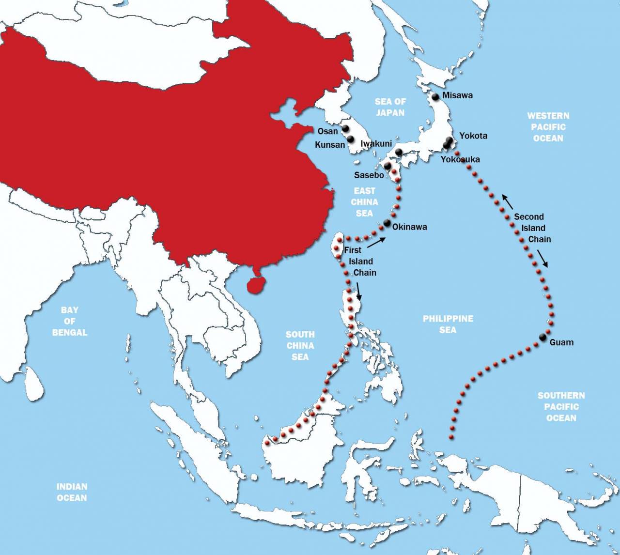
It is with these “defensive” lines, as well as its ability to “plug” the Malacca Strait from the Indian Ocean, the US plans to “plug” China where it is now, stopping Chinese expansion by force, if necessary. The Anglo-Saxons are masters of such affairs, they deal with marine theaters as a grandmaster with a chessboard. And, as you can see, the Chinese, too, is not all easy with access to the ocean. How do they react to it? They build offensive forces, of course. And this is a much smarter reaction than ours, which is the complete absence of reaction in general.
However, with a population that, while imagining a map of the world, simultaneously believes in some opportunities to “go to the ocean” (which was repeatedly voiced at least in discussions about the Poseidon torpedo), another would be surprising.
We can only be glad that we live in peacetime, when all these factors are only potentially. Let us hope that it will remain so, because with the existing approaches to the development of Russia's sea power, we can only hope. Unlike the same Chinese.
Information