Where are you taking us, damn Genoese ?!
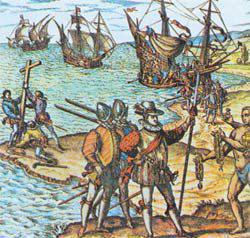 Around 2 o'clock in the morning 12 in October 1492 Spanish sailor Rodrigo de Triana, in the crow nest of the Pinta caravel, shouting "Earth!" Announced the start of a new round of European, and world stories. The expedition of Christopher Columbus, as nothing else, justified the statement "Good luck accompanies the impudent." Going into complete obscurity - a trip across the ocean, inhabited, according to the fathers of the Catholic Church and the regulars of sailor squash, fierce sea creatures, was akin to flying into space. Expeditionary ships, proudly called caravels, were much more modest in size almost any respectable yacht making voyages with a non-poor public in its own pond. About the personnel of the crews that Columbus possessed is not to be said. Obviously, it would be easier to recruit volunteers on an expedition to hell - according to rumors, there was a lot of gold there. “Where does this damned Genoese lead us ?!” - looking at the empty ocean, like an Andalusian fisherman’s purse, the sailors threw evil. Did Columbus know where the Nina, Pinta, and Santa Maria bowls were going? Did he lead his squadron to the shores of India? Or maybe the future admiral knew about the location of the lands lying across the ocean and the fact that they had nothing to do with the legendary Indies and Chipango?
In times of ancient and hidden
For a long time, the so-called ocean of space in the old Europe, which was behind the so-called Pillars of Hercules, or the Strait of Gibraltar, was reasonably called the “Sea of Gloom”. Local navigation was exactly local, that is coastal.
Of course, there is no doubt that eagerly jumped out of the boat into the surf wave of the future island of San Salvador, Columbus was by no means the first person from mainland Europe to set foot on the land of the New World. Archaeologically authentic swimming Normans to Newfoundland and the Canadian coast. There are quite well-argued hypotheses about the campaigns of Arabs, Celts, residents of England and Ireland to the shores of America. The most courageous conjectures suggest a visit to the continent that lies beyond the Atlantic, even the subjects of the pharaohs, the Carthaginians and the Romans.
The question is that, despite the numerous (judging by guesses and assumptions) trips to the New World, none of the navigators could gain a foothold on the newly discovered lands. In any case, at the courts of European monarchs of the end of the XVI century there was no information about the continents lying far to the west. Knowledge and information about pre-Columbian contacts, if they existed, were lost at the public level. Those who were in the subject chose not to advertise their awareness.
In many ways, the lack of interest in the colonization of America among the ancients was dictated by economic reasons.
The main driving force of almost any expansion is the expansion of the economic basis of the metropolis. This includes not only the removal of material values from the local population, but also trade with it, and the trade is profitable. Hypothetically, let us assume that some Greek, Carthaginian or Roman ship, after many months of hardest navigation, finally reaches the shores of America. The hike will be extremely difficult - it is not a coasting dive into the Mediterranean from the port to the port. And not only because of the important in this case, navigation and technical aspects. The big problem of a long autonomous campaign was also the lack of long-term storage provisions. Exhausted by the Atlantic voyage, travelers tread on firm ground and encounter Aboriginal people whose friendliness raises big questions. The difference in the technical equipment of the ancient sailors and the autochthonous population of America is not as critical as in the era of the Spanish colonial conquests. On both sides of the bows and cold weapon, and the Europeans have the best quality. But the outcome of the conflict is solved in the melee, and in it the important factor is the number. And here the advantage of the aborigines will be undeniable. Or suppose that the landing took place peacefully - both sides were able, with the help of gestures and signs, to establish some sort of “diplomatic relations”. If you take bargaining, the inhabitants of America could not offer the newcomers anything extraordinary, except perhaps for jewels. What impression will the survivors leave such a long voyage if the ship, after years of hardships, returns to the shores of Europe? It is unlikely that the first contact in a single historical period was the fruit of a specially prepared expedition. Most likely, the next “discovery” of the New World occurred as a result of a lengthy storm that brought the ship (or several ships) to an unknown land. The crew had to endure the whole set of difficulties accompanying a long hike: hunger, scurvy, depressing morale. The set of trophies is small - rather, they are souvenirs exchanged from locals for ship equipment, of which there are few and irreplaceable.
Of course, information about the successful return of land and overseas overseas will be known in the appropriate environment, but is unlikely to cause panic interest. Earth is very far away. By the standards of the ancient world, just monstrously far. There is nothing special to take there - slaves and valuables can be mined in the Mediterranean basin. The path of many months - big risks. News they discuss it for a while, then gradually it is forgotten. There is no regular communication with new territories. Trading and developing expansion in that direction is simply unprofitable.
Perhaps the scheme indicated here is too typical for the unusual cases with which history is so rich. There is a possibility that the lands of America could become a haven for emigrants who decided to leave their homeland for religious reasons (for example, expulsion of adherents of some cults from Carthage) or political motives. Quite likely in a certain historical period and more or less regular trips across the Atlantic. In any case, for such a, to put it mildly, venerable ancient scholar as Aristotle, the existence of islands located behind the Pillars of Hercules was not a secret. Probably, there could be other documentary information: maps, reports of the expeditions - but the largest repository of ancient documentation was in the irretrievably lost Alexandria Library.
On the technical side, the very possibility of sailing across the ocean was proven by the brilliant reenactor scientists Thor Heyerdahl and Tim Severin. But, obviously, such long journeys did not have much expediency for the inhabitants of ancient Europe. And those who had an interest, kept the information in secret. Some of the best navigators of antiquity, the Carthaginians, were famous for their ability to hide information from outsiders. The main specialization of Carthage - trade - greatly contributed to this. Along with the collapse and death of the Carthaginian state as a result of the Third Punic War, much knowledge and information about trekking and wandering was lost.
Fortunately, not all of the ancient heritage disappeared in the fires of barbarians preparing their lunch, monasteries became a refuge sheltering knowledge from the onslaught of ignorance in the Dark Ages. Despite the public struggle against the remnants of paganism, many documents of the pre-Christian period survived thanks to the efforts of the monks. They were not only stored, but also read. For example, from the book of the Irish monk Dikuil (VII-IX century) it was known that there is information about the lands located far in the west - the islands of Happiness. On later medieval maps, the island of St. Brandan roams to different places. Did Columbus know, peering from the deck of his "Santa Maria" into the horizon, that behind the land hidden behind it? There is reason to believe that yes.
Viking trail
Despite the fact that the volume of literature written about Columbus has long exceeded the total displacement of all three of its caravels, the biography of the great navigator is not as simple as it seems. The accuracy of his date of birth is questioned. Until recently, several Italian cities challenged each other the right to be called the birthplace of the discoverer of America. There are some unexplored white spots in the early life of Columbus. There is some evidence that the Genoese allegedly traveled north in 1477. I visited the English port of Bristol, at the crossroads of many sea roads. According to some researchers, Columbus made an exploratory journey to the shores of Iceland. Behind the scenes of its results. Could the future admiral, having climbed so far into the northern waters, learn something about Viking trips to Vinland, the legends about which could still live in the form of oral folklore?
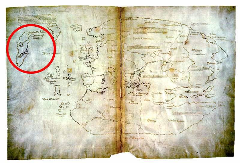
Map showing Vinland
The Norman phenomenon - the campaigns of the northern sea nomads - suddenly began a raider attack in 789 on the coast of England and ended with the battle of Hastings in 1066 on the British Isles. Viking expansion is a large and separate topic. The passionary impulse of the northern peoples was significant. They were no stranger to the risk and calm attitude towards the distance lying behind the stern of the Drakkar. What does Ingvar Traveler's expedition to the Caspian Sea cost in 1010? Europe owes the Vikings the discovery and exploration of Iceland and Greenland. But for the restless bearded man, this was not enough, and they are sent further west. In 986, the Icelandic viking Leif Eriksson reaches an unknown land overgrown with forest, among which “bush with berries from which wine can be made” grows thickly. In any case, a certain member of the crew of Leif, a native of the south, whom everyone called Turk, gave just such a characteristic to this plant. And, according to one of the versions, it was “wine berries” that gave the name of the open land - Vinland. These areas are rich in forest, have caused interest among immigrants from Iceland, where the rocky landscape was poor on suitable vegetation for shipbuilding. Viking trips to the shores of North America were not a secret. First, they are reflected in the oral epic - sagas, for example, in the “Saga of Eric the Red”. Secondly, these campaigns were, to put it in modern terms, documented in the work of the famous chronicler Adam of Bremen “The Geography of the Northern Lands”, which appeared in 1079 year. This was the first description of the discovery of unknown lands in the West at the level of a reputable source at that time, and not a banal retelling of port tales of a “hungry kraken”. Of course, the resilient party of subsequent skeptics, with an ironic smile, indicated that Adam of Bremen’s work was released almost 250 years after Leif Eriksson’s campaign and was based again on Scandinavian sagas, which made it possible to refer this information to the category of “epic creativity”. For a long time, official historiography held a similar opinion, until finally, in 1960, the Norwegian explorer Helge Marcus Ingstad discovered the remains of a Norman settlement in L'Annes-o-Meadows on Newfoundland. Thus, the Viking trips to America were proved, but whether this settlement was the same Vinland or not is still unknown. According to the sagas, the campaigns stopped due to conflicts with the local population.
Did Columbus know where Leif Eriksson went? How much did he have information? On the one hand, in the north, they could still remember the Vikings, not only as ruin monasteries, dashing people, but also as travelers. On the other hand, the information flows of the then Europe were far from dynamic, and the stories about Vinland could be considered fiction. But in any case, there is a possibility that Columbus could have been in contact with the captains of the ships who sailed to Iceland and who knew a lot about the local situation.
Out of familiarity to the unknown
It should be noted that Europe at the end of the XV century was at a crossroads. A number of key events took place that in one way or another influenced the entire course of not only European, but also world history. In 1453, the Ottoman Turks stormed Constantinople, finally deciding on the existence of the last fragment of the once vast Byzantine Empire. Between the Christian world and the mysterious and so attractive countries of the East, an indestructible, as it seemed at that time, bastion of the Ottoman Empire arose. Trade with the East, which was already a difficult matter, became even more problematic. The number of intermediaries who stood in the way of every pinch of pepper, a piece of silk, and other scarce goods — on the way from India, Central Asia, and the Far East — has increased by an order of magnitude. Accordingly, prices rose significantly. Eastern exotic finally goes to the category of VIP-products for the respective categories of consumers. Trading overseas wonders was at the same time extremely profitable and extremely risky. The patency of the traditional ways of getting goods from the east through Constantinople and Egypt was increasingly in doubt due to the frequent wars between Christians and Muslims. There was an acute need for new routes, which were an alternative to those that passed through the territories controlled by the Turks.
Simultaneously with the increasing onslaught from the East on the Iberian Peninsula, an entire epoch was nearing its end - the Reconquista, which had lasted for more than 700 years. The Christian kingdoms gradually, step by step, succeeding in the process of painfully biting and kicking at the opportunity and each other, forced the Arabs out of the territory of modern Spain. By the end of the 15th century, only becoming more and more immersed in a crisis, seized by strife and confusion, the Granada Emirate remained the last Arab state in Europe.
On the Iberian Peninsula, there was another inconspicuous state, which suddenly from the European backwater broke into leadership. It was Portugal. At the beginning of the XV century, the Portuguese entrenched on Madeira, in the 30-s they took control of the Azores. Through the efforts of the active Infanta Heinrich the Navigator, who provided the theoretical and practical basis for the development of maritime affairs in the country, Portugal in a few decades was able to reach the "big league". Having established a navigational school in Sagres and having access to the treasury, this statesman equipped one expedition after another. The Portuguese reached the Cape Verde Islands, explored the mouths of the rivers Senegal and the Gambia. Portuguese ships began to bring gold and ivory to the metropolis. Portugal first became actively involved in the slave trade from Africa. Although the glory of Mediterranean sailors has not yet dimmed, the inhabitants of the Iberian Peninsula intercepted from them the primacy in the maritime business. Humanity has become cramped in the cradle of Western civilization, the Mediterranean Sea. The Portuguese had few of their outposts in Africa - they set the goal of reaching the countries of the East by sea.
It is not at all surprising that Christopher Columbus, armed with expedition projects in "India", first of all began to seek support for his ideas in Portugal. In 1479, Don Philippe Peresherello, daughter of the governor of the islet of Porto Santo (near Madeira), became the wife of Columbus. This same governor was an associate of Prince Enrique himself - Heinrich the Navigator. Columbus manages to go on an expedition to Diogue de Azambosha in Guinea to build a Portuguese fortress there. In addition, the Genoese was in correspondence with the famous scientist and cartographer of the time, Paolo Toscanelli, who had a great influence on the ideas of Columbus. In one of the letters, Toscanelli endorses the Genoese’s idea to go to China by the western route and speaks of a certain map on which this route is indicated. What kind of map it is, whether it was a copy taken from some ancient documents, or if it was drawn by Toscanelli himself, remains a mystery. Perhaps the Italian cartographer had access to certain sources inaccessible to the general public. In any case, Columbus clearly formulates his concept of going to India with the western route, rather than trying to reach it by circling Africa. By the way, the dark period of the Middle Ages with the accompanying savagery and ignorance led to the loss of many knowledge well-known in ancient times: for example, Herodotus reported the Phoenician voyage fleet around Africa back in 600 BC The expedition was ordered by Pharaoh Necho II. It is likely that later, in the heyday of the Carthaginian state (founded, incidentally, by the Phoenicians), this route was known.
In Europe, the period of Columbus, this knowledge has been lost. In any case, many Portuguese navigators seriously believed that to the south of Guinea, known to them, lies the ocean inhabited by monsters and there "can be burned from the bright sun."
Long way to the ocean
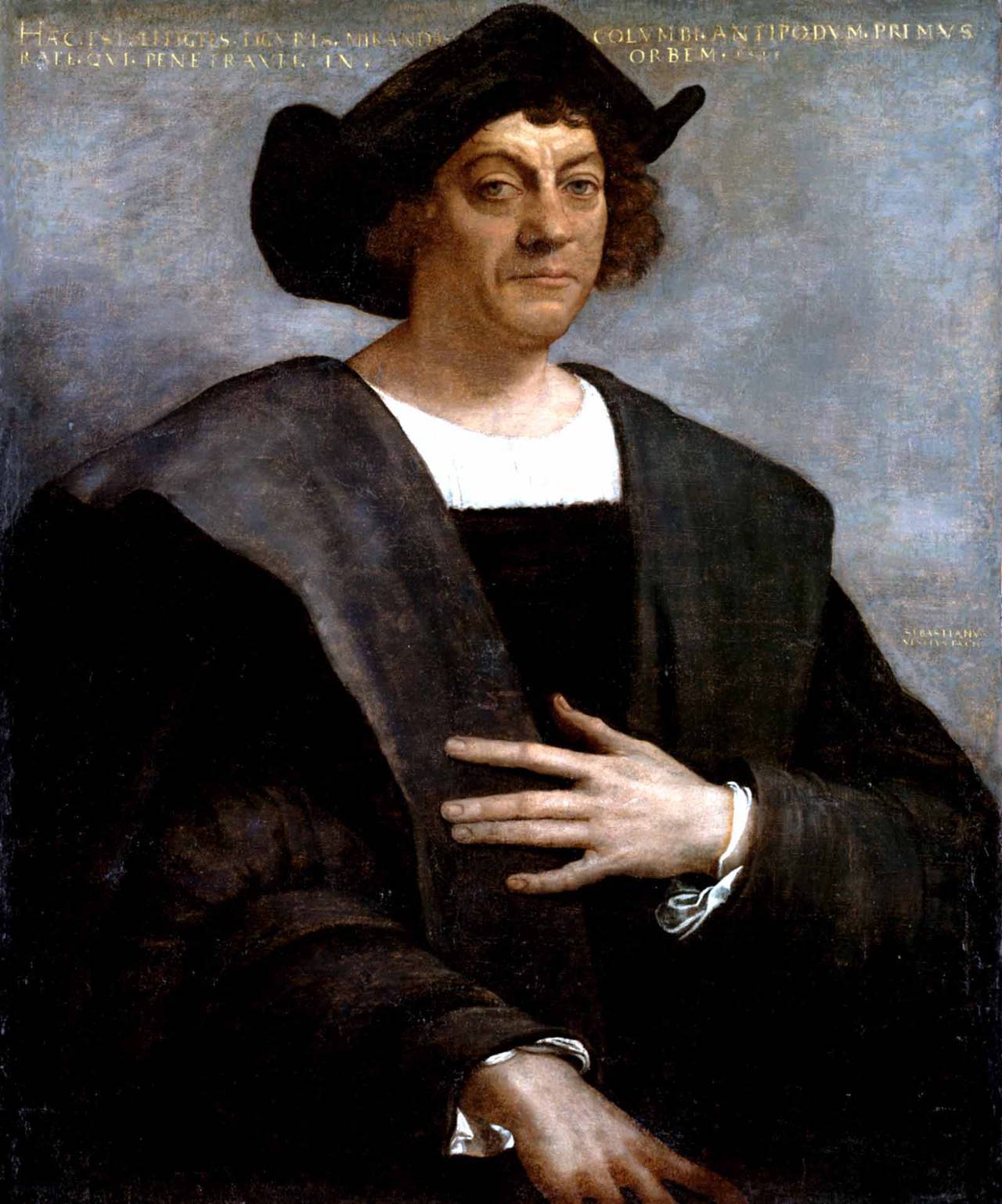
Sebastiano del Piombo. "Portrait of a Man (Christopher Columbus)"
Having arranged everything on paper accordingly, Columbus turned to the Portuguese king, João II. Señor Toscanelli also added fuel to the fire, supporting his correspondent with letters of recommendation and explanatory letters to the court. In one of these epistles to the same João II, Toscanelli says that “from the very familiar to you of the island of Antilia, to nothing, to the other island of Sipangu. The whole interest of the situation lies in the fact that the Antilles officially became known in Europe only after the voyage of Columbus. It turns out that they knew something in Lisbon, but they were silent. While Columbus and Toscanelli, each with their own side, were handling the king, the expedition returned to the metropolis of Bartolomeu Dias, who opened (or rediscovered) the Cape of Good Hope and reached the Indian Ocean again for Europe. Columbus himself was present at the report of Dias João and was hurt to the quick.
The position of the Genoese in the Portuguese court became increasingly precarious. The future admiral, rushing with his ideas on the western route to India, was not taken seriously by Dias against the background of his triumph. Say, we are from Africa to India at hand. It is likely that the Portuguese were deceitful. After all, Prince Enrique was known not only as the patron saint of navigators, but also as a collector of antiquities, in particular, ancient maps and documents. How to know if some documentary evidence of the existence of lands beyond the ocean did not fall into his hands from the same Arabs, who, in contrast to the not yet enlightened Europeans, were much more careful about the heritage of the ancient period. One way or another, but Columbus was given to understand that his ideas do not find understanding. It is likely that the route around Africa in Lisbon was considered more acceptable, short and safe. But at the same time, just in case, they confidently asserted that there was nothing in the west.
Having fairly kept himself up during his stay at the court of João II, Columbus moved to neighboring Spain. There he finds refuge in the monastery of Santa Maria de Rabida. The local abbot Juan Pérez de Marchena, whom the tireless Genoese devoted to the essence of his concept, in what benefit it will bring to the state and the church, expressed interest. The monk was surprisingly "the right person," who was aware of how, to whom and with what "we must come." He is developing a strategy for the correct entry into the high society of Spain. Di Marchena helps to write letters to important people who have access to the very top. One of them was the aristocrat Duke Medinaseli, imbued with the ideas of Columbus and realized that the Genoese was not just another primitive search designer who sells a philosopher stone in bulk. The duke brought him together with his uncle Cardinal Mendoza, Archbishop of Toledo. It was a very good acquaintance - the duke had direct contacts with the Spanish "business elite": bankers, merchants and shipowners. Uncle was entertained by Queen Isabella of Castile. Columbus's efforts to gradually “screw in” into the near-royal circles brought results. He was granted an audience with King Ferdinand of Aragon and his wife Isabella of Castile.
Columbus listened favorably (the cardinal conducted the necessary training), but just in case created a commission of scientists, cartographers and theologians for the possibility of carrying out the expedition. It is quite obvious that the Spanish monarchs who were preparing for a war against the Granada emirate were constrained in their means so that you could live on a great sum for an expedition with dim prospects. The commission itself met for almost four years, bogged down like an elephant in a swamp, in disputes and discussions. Columbus fervently defended his opinion, citing some sources that are evidence of his innocence. He claimed that, while on Madeira, he had repeatedly heard from local mariners about strange finds: hand-processed trees, abandoned boats and other objects west of the Azores. In a narrower circle, the Genoese allegedly claimed that in Bristol he had met with a certain skipper who showed him a map with land marked on it far to the west. Covert Columbus sparingly shared the information available. And this is understandable. At a time when many around were talking about expeditions, about distant Indies and other new lands, every enterprising character could use and turn into profit for someone else’s navigational information. But Columbus was ambitious and did not intend to share his future glory. The commission did not come to an unequivocal conclusion and limited itself to a very streamlined conclusion: there is something in it. In 1491, the monarchs formally refused to provide funds - a military operation against Granada was inevitable. Caught in a quandary, Columbus signs up as a soldier and takes part in the siege and assault of Granada, which fell at the beginning of 1492. In the wake of the general euphoria of victory and joy caused by the end of the Reconquista and the expulsion of the Moors, the Genoese decided to try his luck again.
Ambitions and hidden leverage
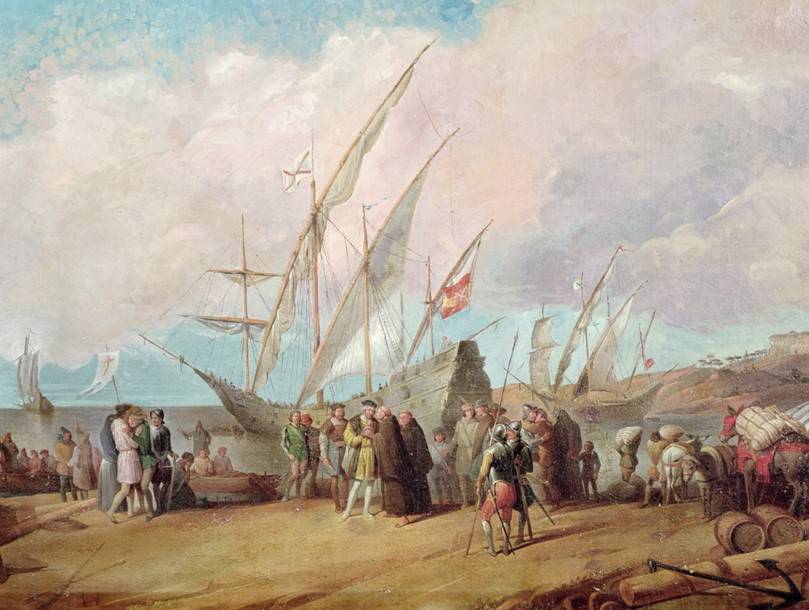
Expedition departure from Palos. Fragment of fresco from the monastery of La Rabida
Columbus hits the most vulnerable spot: after the end of the war, Spain finds itself in a difficult financial situation, while the Genoese promised and even guaranteed huge profits. A lot of belligerent hidalgo, all these don Pedro and Juan, whose whole meaning of life, like their ancestors, was in the reconquista, turned out to be idle. The energy of the poor military nobility had to be sent in the right direction - the struggle against the Berbers was an honorable, but unprofitable undertaking. But to send the owners of the chopped shields and torn camisoles to the development of new territories would be the best way out. Emboldened, Columbus demands titles and titles, but Ferdinand, irritated by the arrogance of the Genoese, again refuses. Columbus publicly threatens to go to France, where he will be understood. But Isabella, who favored the Genoese, intervenes in the protracted discussion. The hidden flywheels of the authorities are twisted, and, it would seem, suddenly the project receives good. Already on 30 on April 1492, the royal couple favors the appeal “don” to the rootless Genoese, that is, makes him a nobleman. It is argued that in case of success of the enterprise, Columbus receives the title of Admiral of the Sea Ocean and becomes the vice-king of all open lands. What made the original decision of the Spanish monarch change, what evidence was provided - remains behind the scenes. Queen Isabella lays part of her own jewels, Columbus finds the rest of the money from the Pinson brothers, the shipowners from Palos. Other influential friends are also helping. But in general, the equipment of the expedition leaves much to be desired. Part of the personnel has to be withdrawn from local prisons - to sail through the sea There are not many people who want to be afraid. But the envious because of skepticism and lack of perspective is not observed, so the fate of the kaverin captain Tatarinov did not threaten Columbus. 3 August 1492 of the year “Pinta”, “Nina” and the flagship “Santa Maria” fall off from the pier of Palos and, accompanied by sympathetic views, go beyond the horizon.
Secrets can wait
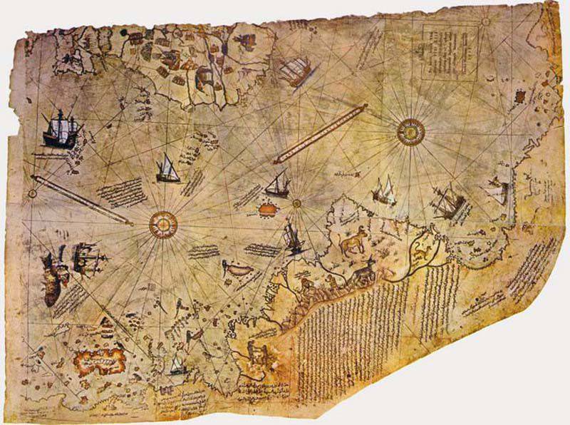
Piri Reis Map
It is unlikely that, before the possible invention of the time machine, it was ascertained whether Columbus knew that the lands to which his squadron was approaching had nothing to do with either China or India? As a result, residents of two continents received the name of the inhabitants of a country located in another part of the world. Did he continue to be in error or played a well-adjusted and rehearsed play, claiming to the end of his days that he had reached the countries of the East? What conclusions did the Genoese make when he saw the sheets of parchment that had faded from time to time with an unknown coastal line in the hands of the mysterious stranger? And was he really? Secrets can wait. As they are waiting for their researchers map of the Berberian Admiral Piri Reis with deposited earth, surprisingly similar to Antarctica, "Erebus" and "Terror", whose rest is kept by the icy waters of Baffin Bay, the airship "Italy", somewhere frozen into the Greenland ice. The story often laughs in response to questions asked. And not only good-natured intonation is heard in her voice.
Information