From the coast of the Baltic Sea to the borders of Iran and China
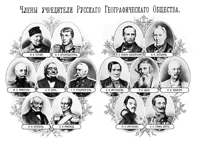
The merits of Russian geographers in exploring and mapping the vast expanses of our homeland and neighboring countries for the 170 years of activity of the Russian Geographical Society are enormous. For many years they have studied and mapped the territory of European Russia, Central and Central Asia, the Caucasus, Iran, India, China and circumpolar countries. The Russian Geographical Society under the leadership of prominent Russian travelers, such as Nikolai Alekseevich Severtsov, Nikolai Mikhailovich Przhevalsky, Petr Petrovich Semenov-Tian-Shansky, Vladimir Afanasyevich Obruchev, Mikhail Vasilyevich Pevtsov, Nikolai Nikolaevich Miklukho-Maklay, Alexander Ivanovich Voeikov, Lev Semenovich Berg and many others, conducted a lot of complex and specialized geographic expeditions.
Military topographers also took an active part in the work of the Russian Geographical Society (RGO), especially during the heyday of its expeditionary activity in 1873 – 1914. The officers and civilians of the Corps of Military Topographers were part of geographic and diplomatic expeditions, made route eye-sight and semi-instrumental surveys of the terrain, from which geographic and topographic maps were subsequently compiled and refined. In a more mature age, having a solid position in the Corps of Military Topographers or after retirement, these same individuals had a significant impact on the work of the RGO, taking up full-time and public positions, planning and directing its activities, personally leading the most important expeditions, conducting scientific research . These wonderful patriots of their country and their profession remain in the memory of the current generation of military topographers and deserve a more detailed coverage of their difficult work.
DIPLOMATS, MILITARY AND TOPOGRAPHS
Prior to the establishment of the Russian Geographical Society in 1845 (the Imperial Russian Geographical Society since 1850), the study of remote territories for military-political purposes was mainly carried out by diplomats and the military, the latter mostly from among the officers of the “quartermaster” unit and the Guards General Staff, later - from the ranks of the Military Topographers Corps (formed in 1822).
Thus, in 1805 – 1806, a diplomatic mission to Beijing was carried out under the leadership of Count Yuri Alexandrovich Golovkin, in which young officers of his imperial majesty retinue for the quartermaster Tenner, Schubert, Dovre, Teslev, Ivanov and Bogdanovich participated. They carried out reconnaissance, itinerary and visual surveys, astronomical determinations. Their work allowed the first detailed maps of southern Siberia and northern China to be compiled. Subsequently, the first four officers from the above list became generals from infantry (in the modern sense - colonel-general), and General Fyodor Fyodorovich Schubert headed the Military Topographical Depot from 1822 to 1843.
According to the materials of route surveys and astronomical observations made by the officers of the suite of His Imperial Majesty in the quartermaster part G.K. Meiendorf, A.K. Timofeev and V.D. Walchowski, during the diplomatic mission to Bukhara (1820), a map was drawn up on the scale of 50 miles in inches to the central part of Central Asia.
In the 1823 expedition of the year, officers of the suite of his imperial majesty in the quartermaster Timofeev, Balkashin, Artyukhov, Tarasov and Karelin participated in the Little Horde of the Kirghiz Steppe under the supervision of Colonel Fedor Fedorovich Berg. According to the results of their work, the Kirghiz-Kaisakov Steppe Steppe Map of the Lesser Horde was published. Subsequently, Field Marshal FF Berg served as chief of the Corps of Military Topographers, and ended his career as vice-governor of his imperial majesty in the Kingdom of Poland.
In the period of 1826 – 1845, a number of significant geographical expeditions to Central Asia and Siberia were conducted, in which officers of the Corps of Military Topographers participated.
In the following years after the establishment of the Russian Geographical Society in 1845, the expeditions began to be more organized and planned. In coordination with the Military Ministry, military or civilian ranks of the Corps of Military Topographers continued to be included in geographic expeditions.
“Topographers had to make surveys in the direction of rivers, roads and mountain ranges, defining distinctive heights and remarkable valleys, convenient for the population and agriculture; according to the rarity of permanent land reports, topographical studies could in places go along with hydrographic ones. Over the entire area of the studied space it was proposed to make a reconnaissance survey; instrumental shooting is used only in the most necessary cases. When surveying hydrographic and topographical, to notice the properties of the earth's surface, that is, meadow, swampy, covered with forest, shrubs, and so on. and associate with items determined astronomically; in addition, measure the relative heights of the mountains in order to have conclusions about the elevation of the soil above sea level ... "- stated in the fundamental work"History half a century of activity of the Imperial Russian Geographical Society 1845 – 1895 ”, published in St. Petersburg in 1896 year.
UNIQUE EXPEDITIONS
The list of RGO expeditions organized from the middle of the XIX century, in which military topographers took part, includes dozens of geographical areas. At the same time, the following expeditions were the most significant for research and mapping of little-studied territories during the heyday of the expeditionary activity of the Russian Geographical Society.
- from 1847 to 1862 year - Ural, Amur, Vilyuisk, Siberian, to Eastern Siberia and the Far East (including Sakhalin), to the lower reaches of the Syr Darya, Khorosanskaya, on land exploration of the Ural Cossacks under the direction of E.K. Hoffman, G.I. Nevelskogo, R.K. Maak, L.E. Schwartz and FB Schmidt, N.A. Severtsova, N.V. Khanykova with the participation of military topographers praporschikov VG Bragin, D.F. Yuriev, P.P. Popova, A.K. Zondhagen, non-commissioned officer G.V. Shabunina, Lieutenant A.E. Alekseeva, non-commissioned officers PI Zharinova and I.I. Petrova (both awarded the Persian gold medal of Leo and the Sun);
- from 1863 to 1877 year - Turkestan, Chukotka, Manchurian, Urun-Darya, Nizhne-Tungusskaya, 1-I Mongolian under the guidance of N.A. Severtsova, E.V. Maydel, Archimandrite Palladium, A.I. Glukhovsky (then A.V. Kaulbars), A.L. Chekanovsky, G.N. Potanin with the participation of military topographers Second Lieutenant A.K. Vyazovsky, non-commissioned officers N. Afanasyev, G.I. Squish, Colonel S.I. Zhilinsky, lieutenants N.S. Kusikova, F.P. Petrova, non-commissioned officers V.A. Shimanovsky and Ulyanov, Lieutenant P.A. Rafailova;
- with 1878 of 1892 year - Fergana-Pamir, on the study of the watershed of the rivers Ob and Yenisei, 2-I Mongolian, to study the old riverbed of the Amu Darya river, to study the Zeravshan glacier, Amu Darya, the Bukhara land Gansuyskaya in Bukhara possession Research Khan-Tengri glaciers, to study the border with China spaces within the Irkutsk province under the leadership of N. And. Severtsova, B.A. Aminova, G.N. Potanin, A.I. Glukhovsky, I.V. Mushketova, A.E. Gedroyts, A.E. Regel, G.E. Groom Grzhimailo, I.V. Ignatiev, Lieutenant Colonel N.P. General Staff Boby with the participation of military topographers VS Rudneva, A.I. Scassi, A.F. Fedorovich, N.K. Hondazhevskogo, T.T. Sergeeva, P.I. Tochalov, staff captain P.D. Orlova, non-commissioned officer V.A. Eliseev, staff captain F.P. Kosancic, I.P. Ivanova, L.A. Meldau, G.M. Petrova, P.E. Kosyakova, A.V. Caesarean, captain G.E. Rodionova, A.A. Alexandrov, lieutenant colonel Yu.A. Schmidt, non-commissioned officer K.A. Eliseev;
 - from 1893 to 1909 year - Kola (Varguza river basin), Khatanga, Mongol under the direction of P. B. Rippas, I.P. Tolmachev, Colonel P.K. Kozlov with the participation of military topographers Second Lieutenant A.A. Noskov, captain M.YA. Kozhevnikov, captain P.Ya. Napalkova.
Even a highly generalized slice of the expeditionary activity of the Russian Geographical Society and the participation of military topographers in it in a rather short time period is impressive.
For example, 16 of large expeditions of the Russian Geographical Society to Central Asia made an invaluable contribution to the mapping of this territory. During the expeditions 95 473 km were traced and captured, 363 astronomical points were determined and 3 points 533 heights were measured. The position of the main mountain ranges and river systems, as well as the lake basins of Central Asia, was clarified. All this greatly contributed to the creation of modern topographic maps.
With the active participation of the Russian Geographical Society, military topographers conducted a large number of pioneer reconnaissance surveys in the Far East, Siberia, Kazakhstan, and Central Asia, during which maps of many territories that were previously white spots on the map were drawn up.
For participation in geographical expeditions and a significant contribution to the mapping of poorly explored territories, many military topographers were awarded the Russian Geographical Society.
The highest distinction - the Big Gold (Konstantinovskaya) medal was awarded to: Lieutenant Colonel B.F. Lemm - “for the astronomical definitions of the latitudes and longitudes of many points in Russia and in Asia” (1850); Lieutenant-General I.I. Khodzko - “for his work in favor of the geography of the Caucasus” (1868); Colonel I.I. Stebnitsky - for his work "On the deviations of steep lines by the pull of the Caucasus Mountains" (1872); Col. IA Strelbitsky - for the work "Calculating the surface of the Russian Empire" (1875); Col. K.V. Scharngorst - “for astronomical works on the definition of the difference in longitude by telegraph from Moscow to Vladivostok” (1876); Major General M.N. Lebedev - for his work "Description of triangulation in Bulgaria, produced in 1877, 1878 and 1879 years" (1888).
Many military topographers for outstanding professional achievements and works were awarded the Small Gold Medal of the Russian Geographical Society: Major General O.E. Stubendorf, E.A. Koversky, colonels A.A. Bol'shev, I.I. Stebnitsky, A.A. Tillo, S.S. Tyutikov, lieutenant colonel DD Sergievsky, captains A.F. Golubev, M.Ya. Kozhevnikov, P.Ya. Napalkov, non-commissioned officer G.I. Squinting, titular adviser N.A. Bendersky, collegiate adviser A.I. Scassi.
In the 19th century, the Russian Geographical Society established a number of other awards to distinguish outstanding geographers and travelers. In particular, the gold medal named after Count F.P. Litke and the Silver Medal, which among other researchers have been noted, and many of the ranks of the Corps of military topographers. Of particular note is the award of the Gold Medal to military topographers - scientists Major-General D.D. Gedeonov ("for the entire totality of his long and extensive work in various areas of geodesy, topography and applied mathematics", 1905 year) and Lieutenant-General V.V. Vitkovsky (“for his many years of work in geodesy and practical astronomy, expressed in a whole series of serious and outstanding works in these branches of science”, 1909 year). The latter, by the way, for a certain period of his military service served as chief of the Nikolaev Academy of the General Staff.
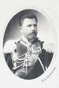
In addition to participating in expeditionary research, many military topographers occupied prominent leadership and socially important positions in the Russian Geographical Society, engaged in planning its activities and reviewing the results of geographical discoveries and expeditions. Among them: General of Infantry N.D. Artamonov - Head of the Military Topographical Department of the General Staff and the Corps of Military Topographers (1903 – 1911); Infantry General A.R. Bonsdorf, Head of Western Border Space Triangulation (1904 – 1913); Lieutenant-General V.V. Vitkovsky, Head of the Department of Geodesy and Astronomy of the Nikolaev Academy of the General Staff (1897 – 1918); Major General D.D. Gedeonov, Head of the Turkestan Military Topographic Department (1900 – 1908); Infantry General S.I. Zhilinsky, head of the Turkestan military topographic department (1870 – 1900); Lieutenant-General E.A. Koversky, Head of Survey, St. Petersburg Province and Finland (1904 – 1916); Lieutenant General S.S. Kozlovsky, Survey Manager of the North-West Frontier Space (1911 – 1918); Lieutenant-General P.P. Kulberg, Head of the Caucasian Military Topographic Department (1892 – 1909); Infantry General I.I. Pomerantsev, Head of the Military Topographical Department of the General Staff and the Corps of Military Topographers (1911 – 1917); Lieutenant General S.S. Rekhnevsky, Professor of the Department of Geodesy and Astronomy of the Nikolaev Academy of the General Staff (1858 – 1879); Major General S.D. Rylke, Head of Survey, Southwest Frontier Space (1892 – 1899); Infantry General I.I. Stebnitsky, Head of the Military Topographical Department of the General Staff and the Corps of Military Topographers (1885 – 1896); Lieutenant-General A.A. Tillo, head of the Orenburg military topographic department (1868 – 1871); General of Infantry PA Tuchkov, Director of the Military Topographical Depot (1843 – 1855); Lieutenant-General I.I. Khodzko, Head of the Caucasus Military Topographic Department (1854 – 1867); General of Infantry O.E. Stubendorf, Head of the Military Topographical Department of the General Staff and the Corps of Military Topographers (1897 – 1903).
MODERN PERIOD
In Soviet times, the communications of geographers and military topographers were no longer so close. During this period, it was not customary for topographical officers to be members of civil society organizations. Nevertheless, the interchange of cartographic and geographical information between the All-Union Geographical Society, the General Directorate of Geodesy and Cartography at the Council of Ministers of the USSR and the Military Topographic Service of the Red (Soviet) Army was organized at a good working level. The technology of creating geographical maps necessarily included the use of up-to-date topographic information. Tracked and mutual successes in geographical discoveries.
In 1947, the PP Gold Medal. Semenova All-Union Geographical Society awarded a group of military topographers who, in the most difficult high-mountain conditions, determined the height of the Peak of Victory, the highest point of Tien Shan. This award was awarded to the engineer-lieutenant colonel P.N. Rapasov, senior lieutenant N.Ya. Gamaleev and senior technician-lieutenant A.F. Koksharov. In 1954, the All-Union Geographical Society awarded the SI Award for outstanding scientific works in the field of geographical sciences. Dezhnev officers of the Military Topographic Service of the Soviet Army, Lieutenant Colonel L.А. Bogomolov and Lieutenant Colonel G.V. Zakharov.
At present, professional ties between geographers and military topographers have not only been restored, but they are getting stronger every year and continue to expand from one joint project to another, from one expedition to another.
An example is the long joint research work of specialists of the St. Petersburg Society of Geodesy and Cartography and military surveyors of the St. Petersburg Higher Military Topographical Command School named after Army General A.I. Antonov (now - the faculty of topographic and geodetic support and cartography of the Mozhaisky Military Space Academy) in 1990-ies (headed by Colonel Yu.G. Sokolov) for the restoration of geodetic points laid down in the XIX century when creating the “Russian-Scandinavian arc "(the modern name is" Struve Geodetic Arc "- GDS). Today, the restored astronomical and geodetic point Struve on about. Gogland is the oldest point in the state planning base in Russia and the only item remaining in the country GDS. In 2005, UNESCO recognized the GDS as a World Heritage Cultural Monument.
Also with the participation of military topographers and hydrographs in the framework of the project “Russian arc of the meridian: Russia - Belarus” approved by the Presidium of the Russian Geographical Society, in the course of joint exploration, the original centers of the GDS of the 2000-kilometer Oovnitsky basis were found in the Republic of Belarus during the joint search.
The important joint project of the Russian Geographical Society and the Topographic Service of the Armed Forces of the Russian Federation was the assignment in the year 2006 of the name of the outstanding military topographer V.V. Vitkovskogo street in the Vyborgsky district of St. Petersburg.
Particularly fruitful began to interact geographers and military topographers from 2011, when Sergey Kuzhugetovich Shoigu, President of the Russian Geographical Society, became the Minister of Defense of the Russian Federation. An example of a successful joint expeditionary activity of the Russian Geographical Society and military topographers is the search expedition conducted on May-June 2015 to the outer islands of the Gogland Gulf of Finland. Representatives of the faculty of topographic and geodetic support and cartography of the AF Aerospace Military Space Academy took part in the expedition and carried out special topographic, geodesic and cartographic works. Mozhaiskogo Colonels A.G. Domoroschenko and A.N. Kotsyuba, Yu.N. Simonov. In particular, the military topographers who became the well-known island of Bolshoi Tyuters, carried out topographic reconnaissance of the area, created a photocircuit and a large-scale electronic topographic map of the island’s territory, coordinated detected weapons and military equipment, developed optimal routes for their movement to 166 objects with historical value, prepared materials for creating digital 3D images.
 It should be noted that at present, the joint work of the Russian Geographical Society and the Military Topographical Directorate of the General Staff of the Armed Forces of the Russian Federation is not limited only to expeditionary and exhibition activities, there is a serious and interested work on preparing proposals for the development of the geodesy and cartography industry in Russia. Other new joint projects are also planned.
LEARN OUR EARTH
The 170-year-old activity of the Russian Geographical Society is multifaceted and extremely useful for improving Russian statehood. Detailed study and mapping of its vast territory provides the initial message for its rapid development, and the clarification of borders with neighboring countries contributes to the establishment of good-neighborly peaceful relations for many years.
All these years, military topographers have been close to geographers. They compiled route maps and city plans, made astronomical definitions, communicated the required topographic, geodetic and navigation data to the troops and other state institutions.
The modern world is geographically already largely studied. We have incomparably more effective means of obtaining information about the locality than our dear colleagues 100 – 150 years ago. But we want to know more. We want to see the Earth’s surface in real time, we want to know very accurately the shape and gravimetric properties of our planet, we want to know the World Ocean, we want to make accurate geomagnetic and climatic forecasts, we always want to know where we are and what direction we are going. , we want to go beyond the limits of earthly space - there we will find work too.
For this, it is necessary to develop the Earth sciences, first of all - geography, oceanography, geodesy and cartography. As before, military and civilian geographers and topographers should work together, this is the key to success. Our respected predecessors, geographers and military topographers of past centuries, serve as an example.
Information