Slaver Island in Africa

12
Kunta Kinte Island
Kunta Kinte Island


The smallest country on mainland Africa may seem completely unremarkable at first glance. It stretches along the Gambia River and is surrounded by Senegal. But in stories The country has a tragic and dark period, since slaves were actively exported along the Gambia River - it flows into the Atlantic Ocean.


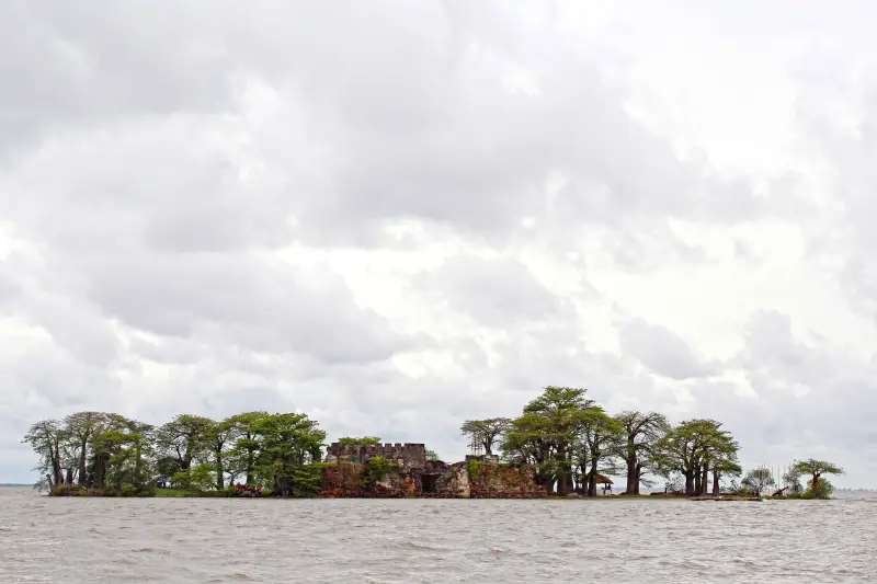
Slave ships have been arriving on one island for centuries. Kunta Kinte, located 30 km from the river mouth, remains one of The Gambia's most visited sites and is also a UNESCO World Heritage Site.

The beginning of the history of the island of Kunta Kinte


The first explorers to reach Kunta Kinte were the Portuguese and Italians. In May 1456, the island was discovered by two Italian explorers leading a Portuguese expedition. These were the Genoese trader Usus di Mare and the Venetian explorer Alvise Cadamosto. They landed on the island to bury one of their dead shipmates. From that moment on, the island was known to everyone as St. Andrew's Island - it was named after the deceased.

Just two years later, the famous Portuguese navigator Diogo Gomes also landed here, and the Portuguese acquired the island from the local rulers, almost immediately starting construction of a fort. Opposite they built a settlement known as Saint-Domingue.

Soon enough, the island will become a center of cultural exchange between Europe and Africa. Trade routes will be established. Alas, it will soon take on a menacing aspect that will scar the world for centuries to come. This dark feature was the slave trade.

The Gambia River is one of the most navigable in Africa. At first the island of Kunta Kinte was a fort and trading port, but it soon became a central point for the shipment of slaves.

The vast majority of African slaves who were shipped across the Atlantic from this island were actually brought by other Africans. They were either captives for whom representatives of their tribes did not pay a ransom, or simply kidnapped to be sold into slavery.

One way or another, European settlers stumbled upon a complex network of warring African tribes, most of whom sought to sell their compatriots and doom them to a grim fate overseas.

Hand in Hand


Of course, not only slaves were traded on this island.

The best goods of Africa were also exported from here: ivory, gold, precious stones, ores. After popularity, the name was changed to James Island. And it remained with it until 2011, when it was renamed Kunta Kinte, a truly Gambian name.

The next owners of the island came from Courland. I really didn’t think that the Courland traders had reached those places.

After purchasing the island around 1651, they began building a more powerful fort and used the island as a base to establish trade routes between Africa and the Baltic. The goal of the Courlanders was to establish a permanent settlement here.

Soon pastors and couples were sent to the island to settle. The fort was built in accordance with traditional construction methods of the Polish-Lithuanian Commonwealth. It was rectangular with powerful bastions at each corner.

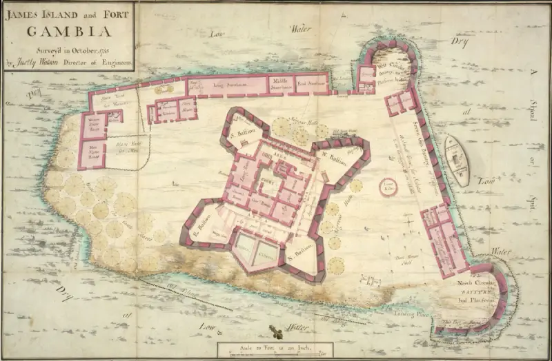
Map of the fort, 1775

From that moment on, everyone wanted to get a piece of the wealth that was in The Gambia.

The Duke of Courland was determined to organize a full-fledged serious expedition to colonize these lands, but he lacked people and experienced commanders. For this reason, he was forced to rely on foreign navigators. His first expedition under the command of a Dutchman was a failure.

The second expedition, led by a Dane, also failed.

In the course of subsequent events, due to political instability in the Polish-Lithuanian Commonwealth, the garrison of James Island lost contact with their homeland. The Dutch quickly took advantage of this instability by offering to help supply the island in exchange for complete control of it. As a result, the island passed into their hands.

In the subsequent period, there were many conflicts between the Courlanders and the Dutch over control of the island. The fort was sacked several times, and the garrison was reduced to only seven people.

The Dutch briefly controlled the island until the British arrived. They captured Kunta Kinte in 1661.

The company received a royal charter from Charles II and dealt mainly in gold, ivory and slaves. The British began building a larger fort.

However, in the following decades the French harassed them, stopping construction and trying to subjugate the island. Nevertheless, the British firmly held James Island, because it was their first outpost in West Africa and an excellent source of income.

But in 1779, French troops launched a full-scale attack on the island fort, managing to dislodge the British and plunder the island.

By 1815 the island was abandoned forever and the fort was never rebuilt.
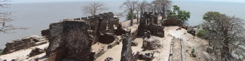
Remains of the fort
Remains of the fort

Today tourists visit the ruins of the fort. The remains of the fortress walls, slave houses, shops, forges and the governor's kitchens have been preserved.

Both the island and the ruins on it are threatened by erosion and rising water levels. Heavy rains and hurricanes that occurred in August 2016 led to the destruction and damage of buildings and partial flooding of the island, which decreased in size.
12 comments
Information
Dear reader, to leave comments on the publication, you must sign in.
  1. +9
    25 March 2024 04: 31
    Interesting story. Unfortunately, the Author limited himself to publicly available and well-known information.
    For example, he did not disclose the reasons for the Portuguese leaving James Island.
    The naval flag of the Confust of Courland is interesting; it is central in the picture.
    1. +4
      25 March 2024 04: 36
      Quote: Kote pane Kohanka
      The author limited himself to publicly available and generally known information.
      For example, he did not disclose the reasons for the Portuguese leaving James Island.

      Dear Vladislav, when I read this article, the same thought came to me. I am sure that the history of this island is worthy of a series of articles. Alas, there are not many authors capable of this in VO.
      1. 0
        30 March 2024 13: 13
        Yes, here about only the Duchy of Courland and the attempts of ONE person, who invested everything he had in these colonies, asked for help from Poland, even Russia (!), the Germans and the Dutch - you can dash off articles 2-3.
        And this man had THREE personal colonies - this island, in South America and the Caribbean - all failed due to the fact that his native duchy was poor, and Poland did not care about these colonies. Poland (Rzeczpospolita) was just beginning to be divided at that time.
        And all these merits and labors in colonization took place while he was alive. He didn’t even give up trying to help the beggars.
        Very interesting stuff.
    2. +6
      25 March 2024 07: 09
      Quote: Kote pane Kohanka
      reasons for the Portuguese leaving James Island

      Yes, there were almost no Portuguese there. There were small trading posts for trading with local tribes. Then Portugal fell under the rule of Spain and, probably, they had no time for some island there, when all of America and Southeast Africa lay before them. Well, how did this island get to the Duke of Courland? History says he was just bought from a local leader who arrived there with the crew of a Courland ship, who founded a settlement there focused on agriculture...
  2. +6
    25 March 2024 05: 51
    The next owners of the island came from Courland. I really didn’t think that the Courland traders had reached those places.
    Apparently, the author learned this after a thorough study of the sources. Latvian. In the original.
    1. +7
      25 March 2024 10: 22
      Apparently, the author learned this after a thorough study of the sources. Latvian. In the original.

      By the way - in addition to colonial possessions in Africa, Courland also had a colony in South America - New Courland in Tobago.
      1. +4
        25 March 2024 17: 55
        hi They tried to found one nearby in Trinidad, but it didn’t work out.
  3. +11
    25 March 2024 06: 35
    And from memory right away, bam! *Oh no. I’m not Negoro, I’m Captain Sebastian Pereira, an ebony merchant. Have you heard? No?...* bully
  4. +7
    25 March 2024 10: 15
    European settlers encountered a complex network of warring African tribes, most of whom sought to sell their countrymen and condemn them to a grim fate overseas.
    The Europeans successfully used the principle of divide and conquer.
  5. +7
    25 March 2024 13: 23
    Heavy rains and hurricanes that occurred in August 2016 led to the destruction and damage of buildings and partial flooding of the island, which decreased in size.

    The first thing that surprised me in this material was the small size of the island and its insignificant height, clearly visible in the photo. I immediately thought that the island could not be an ocean island - it would simply be overwhelmed by waves. I looked at the map - indeed, 30 km. from the mouth of the river, but inland. Now it does not exceed 130 meters along the long side. It’s a pity that you can’t make out the scale on the old map, otherwise it would be possible to compare its current size with long ago, from the time of its eventful history.
    Wow - “the central point for sending slaves,” a place from where “the best goods of Africa were exported: ivory, gold, precious stones, ores,” and all on such a tiny piece of land, in the middle of a mighty river. Although, there could simply be an “office” for making deals.
    1. +3
      25 March 2024 15: 20
      It’s a pity that you can’t make out the scale on the old map, otherwise it would be possible to compare its current size with long ago, from the time of its eventful history.

      The current area of ​​the island is approximately 1/6 of the area that the island occupied at the time described in the article.
      Wow - “the central point for sending slaves”, a place from where “the best goods of Africa were exported: ivory, gold, precious stones, ores”, and all on such a tiny piece of land

      It’s just that the author, as usual, copied and pasted some kind of tourist brochure or something similar. Zotovism is Zotovism. In fact, the main base was located on the island. Trade was carried out through a network of trading posts, of which the Courlanders had thirteen.
      The island was alternately owned by the Portuguese, Courland, the British, the Dutch, and the French. The island was both the center of the slave trade, through which, according to modern estimates, about 3 million slaves were exported, and the center of the fight against the slave trade. Six-Gun Battery (1816) and Fort Bullen (1826), the ruins of which still remain today, were built by the British to combat the slave trade.
      1. -2
        25 March 2024 19: 46
        It’s a pity that I can’t read your historical articles) perhaps because you can’t write? I would read it with pleasure. Since you comment a lot here and find something interesting on all topics, you should try to write, show us, uneducated authors, an example!
        What I saw in the profile does not look historical or professional)