About the situation in the ports of Ukraine
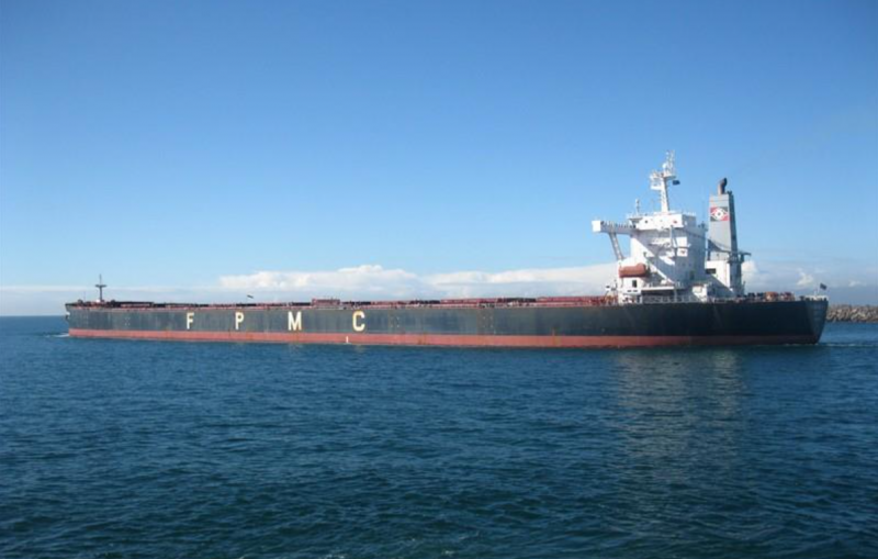
This is Smoke, its length is 290 meters, its width is 45 meters, and its deadweight (which is almost equal to its carrying capacity) is 170 tons. Now it is anchored near the border of Ukrainian waters and is waiting for a command to move further.
As soon as someone writes somewhere about a grain deal, comments immediately appear like “there’s barely one or two ships a month, but we’ll drown everyone, and the insurers have set such rates that no one will agree, and there are all the ports.” broken and destroyed”... And so on. And I began to wonder - how does this all really happen? And I tried to collect my own statistics and was very successful in this. The results, I suspect, will shock some.
I began my intelligence activities on November 7 of this year, 2023. Actually, you don’t need to make any special efforts for this - everything is on such resources as marinetraffic, fleetmon and the like. Well, when I collected a lot of data, I kept it to 30–35 minutes a day. I'm currently on a break from work, so it's not stressful at all.
First, a few words about how data about the location of a ship ends up on the World Wide Web. For people associated with the sea, this is nothing unusual, but for others, who are the majority, it may be interesting. And those who doubt can easily check everything in person.
In the early 2000s, the global maritime community once again became concerned about the safety of navigation, and as a result, on ships of the world maritime fleet began to install equipment everywhere called AIS - Automated Identification System. This is what the indicator of this system looks like:
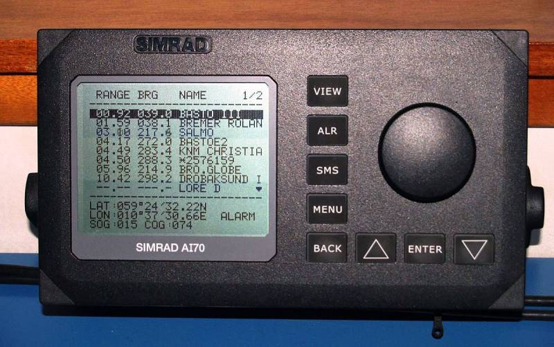
The system continuously transmits two types of information to everyone who has similar equipment.
The first is course, speed, coordinates, exact time and other data received from ship sensors. There is no way to change them.
Another category is data entered by the ship's crew. This is the name of the vessel, status (at anchor, in motion), draft, port of departure/destination and some others.
There is also data that can only be changed using a password - the name of the vessel and its identification numbers. The same information is received from neighboring ships, and as a result, we see on the screen approximately what is shown in the picture. If you click on the corresponding line, the menu will open and show the details of the vessel you are interested in.
There are also AIS stations on the shore, and information from them is used by traffic control posts. Well, the creators of marinetraffic and others have found a way to use this data.
There are, of course, nuances.
The first AIS used the VHF band, resulting in a receiving range within visual range. Taking into account the height of the ship's antenna, it turned out to be 50 kilometers, and then the signal disappeared. Modern systems, in addition to VHF, also have satellite antennas, and theoretically information can be transmitted and received from anywhere. Either from Antarctica or from the middle of the Pacific Ocean. But for you and me, sitting at home on the couch, it is inaccessible. Although, if you really want to, then you can. Marinetraffic has several types of paid access with prices ranging from 2 to 000 rubles per month.
Thus, if, out of the blue, you go to marinetraffic and hover your cursor, for example, at Odessa, then you can really see one lonely steamer, or even nothing at all. And the sea along the coast is empty, only a few small marks are lost.
In fact, there are steamships there, but their transponders are turned off, and they are invisible to the average observer. Fleetmon seems to immediately erase such a vessel from the map, and marinetraffic keeps in memory for one day and then also removes its mark. It is possible to track such a ship, but you need to know its name or identification number, and be sure that it is in port. For example, I know for sure that there are five ships in Yuzhny and I know their names, but only one is visible. Let's open marinetraffic and type a well-known name, for example, Lucky Glory:
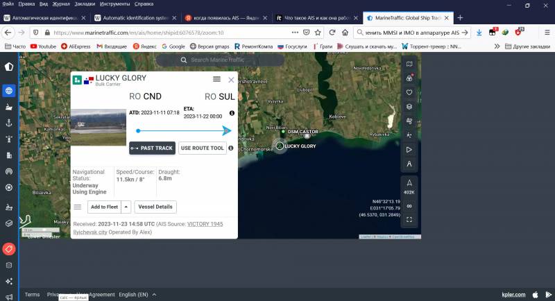
The last known position of the vessel was received on November 23, and since then the vessel has been classified as out of range and is no longer visible on the map. If you don’t know in advance that it was in Yuzhny, then later it can only be discovered by accident or not paid attention to it at all. You need to start surveillance early.
But enough of the theory, let's get to practice.
It is known from the press that after the termination of the grain deal, Ukraine developed an alternative safe route. Nobody, of course, drew this route on the map, but it is clear that it should pass along the coasts of neutral, so to speak, countries. Namely Turkey, Bulgaria and Romania.
Ideally, it is generally advisable for ships to stay in the territorial waters of these countries, where our warships cannot go. But in reality, it seems that they stay somewhere 50-60 km from the coast and eventually gather in a group at the roadstead of the Romanian port of Sulina.
Let's open fleetmon - it offers a full-screen view, unlike marinetraffic - and sort the types of vessels that interest us. We select “the name of the vessel is always visible”, remove the checkbox from tankers and set the length of the vessel starting from 140 meters - this way we will set the minimum deadweight to approximately 25 thousand tons and weed out every little thing.
Unfortunately, it will not be possible to separate bulk carriers, container ships and general cargo separately - they all fall into the cargo ships section. But it’s not bad either. And what do we see (on November 28, approximately 7 Moscow time)?
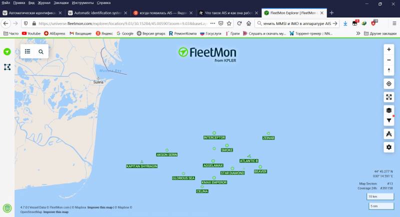
Round marks – ships at anchor, triangles – ships in motion. If you hover your mouse over the triangle, in most cases we will see a speed of 5–3 knots - that is, these individuals, most likely, for some reason, did not drop anchor and decided to drift. And okay, they know better there.
Next you need to turn on the logic. First let's see what the AIS shows about your destination. The majority – interestingly – head specifically to the small port of Sulina, which has a single berth with depths of up to 7,5 meters. Even the huge Smoke, with a length of 290 meters, a deadweight of 180 thousand tons and a draft of 18 meters, was aimed there. Hard to believe. Although there are exceptions: Kmax Emperor and Interceptor honestly showed Chernomorsk.
We remember this group and will update the results tomorrow. If we're lucky, we'll see one of them head for Ukrainian waters. The border is up there, indicated by a purple squiggle. This is what the situation looked like at the raid on November 13:
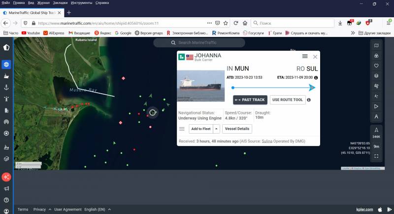
Here we see several triangles crossing the conventional border, of which one vessel, Johanna, is highlighted. Moreover, the data about it was received three and a half hours ago and has not been updated since then - apparently, the AIS equipment was simply turned off. Let's take the same path that I did and follow “Joanna” further.
And then Johanna showed up the next day in Yuzhny:
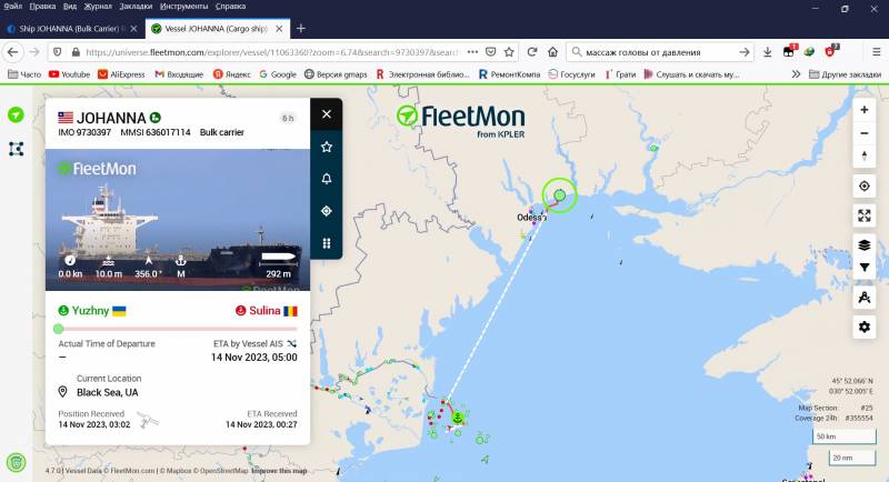
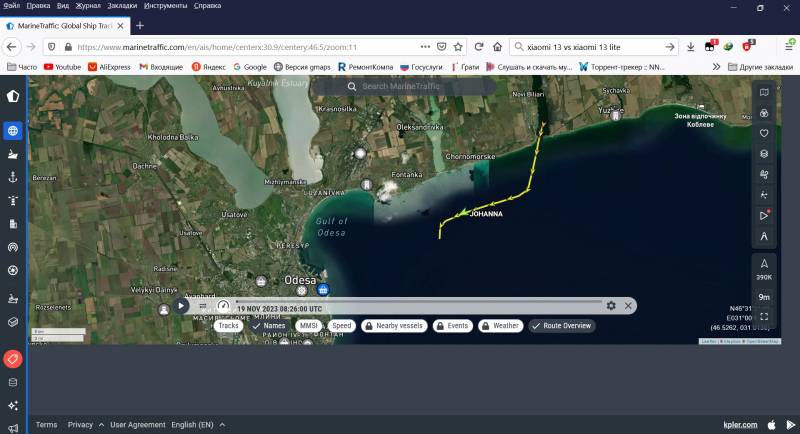
And she disappeared until November 20, when she became visible again:
The destination (it is not visible in this photo, but believe me) is Istanbul, but this is understandable, we must somehow pass the Bosphorus. Naturally, she did not stay in Istanbul, but moved to the Mediterranean Sea, without indicating her destination until a certain moment. But then this too became clear – China, Qingdao. At this point I stopped pursuing her, everything is clear.
I won’t describe the whole procedure day by day, but the result is this: starting from November 7, 61 ships were included in my list. And these are only those with a carrying capacity of more than 20 thousand tons, which visited only the large ports of Chernomorsk - Odessa - Yuzhny, and only bulk carriers. There is this type of ship designed for transporting bulk cargo. Although it is possible to use timber, metal ingots, pipes, and wind generator casings... But in the case of Ukraine this is unlikely. Grain, coal, ore. The trifles that filled the Danube with its ports were not taken into account.
And I must keep in mind that I might not have noticed someone. There have been several occasions when an unknown name has appeared in the vicinity of the ports, which I had not seen before.
Most of the ships stayed in the ports for 5-7 days, some more - that is, cargo work there is carried out quite intensively. Although there are exceptions, for example, DSM London with a deadweight of 35 thousand tons stayed in Odessa for 10 days.
They enter ports with a draft of 4–7 depending on the size - this means that the ships are empty, and leave loaded with up to 10–14 and even up to 18 meters - the latter for giants by local standards with a deadweight of 180 thousand tons. There are also such, there are four of them, and there is another one at the Sulina roadstead, waiting in line. Draft, as I already said, is a parameter that must be entered by the crew, so you can draw anything there, but still...
Now the most interesting thing: the total cargo capacity of this pile is almost 3 tons.
So it goes.
But, on the other hand, our Ministry of Defense never promised to “drown them all” and did not even threaten to block Ukrainian ports.
Information