In the Airborne Forces completed tests of the intelligence complex "Iskatel" with an unmanned aerial vehicle

26
In the Airborne Forces completed tests of the intelligence complex "Iskatel" with an unmanned aerial vehicle

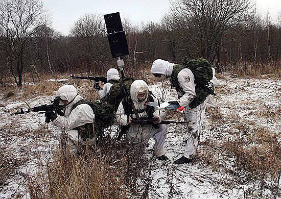
In the Tula unit of the Airborne Forces (Airborne Forces), military tests of the small-scale reconnaissance complex Iskatel with an unmanned aerial vehicle (UAV) T-4 of Russian production were completed.

During the tests, the paratroopers expressed a number of comments to the developers, which will be taken into account in the work on the further improvement of the complex in accordance with the requirements of the combat use of the Airborne Forces.

Thus, according to the commander of the Tula Airborne Division of the Guard Colonel Anatoly Kochetkov, the total weight of the complex should be reduced from kg 9-10 kg to at least kg 6-7. “Then it can be considered really wearable,” the officer explained.

“The range of the complex, that is, the distance from which the Iskatel is capable of transmitting a clear video image, is 8-10 km, and this is exactly the range of our artillery fire, which suits us perfectly,” continued Kochetkov. "But the flight time, which today is about 40 minutes, in our opinion, needs to be increased at least one and a half times," he said.

Another requirement of paratroopers to the complex was the need to equip it with the equipment of the domestic global navigation satellite system GLONASS (currently the complex is equipped with a GPS navigation system).

In the near future, the Iskatel small-size reconnaissance complex will be demonstrated to the commander of the Airborne Forces, Colonel-General Vladimir Shamanov, who will give final instructions on how to finalize the complex in accordance with the tasks of the Airborne Forces.

The "Iskatel" complex consists of a base station, which is placed in a backpack, a tablet computer (image from cameras is transmitted to it). drones, it also serves as a UAV control console) and two T-4 UAVs weighing 1,3 kg each. The UAV is launched from the hand, the flight duration is 40 minutes. The UAV transmits the optimal image of the terrain from a height of 200 m, but is able to rise to a height of up to 4 thousand m, that is, to work in mountainous areas. The UAV is equipped with an electric motor, the wingspan of the device is 0,6 m.
26 comments
Information
Dear reader, to leave comments on the publication, you must sign in.
  1. Lech e-mine
    +34
    18 December 2012 12: 20
    GPS again
    In Georgia, at one time, HAMERS were captured with interesting equipment for working with GPS
    there is an interesting program there that allows you to change the ground level mark
    I believe that all equipment working with GPS is potentially dangerous for us - something can happen to him at any time for unknown reasons.
    1. +20
      18 December 2012 12: 40
      Quote: Leha e-mine
      I believe that all equipment working with GPS is potentially dangerous for us - something can happen to him at any time for unknown reasons.

      Rather, at one point, the connection with the GPS system will disappear and all equipment tied to it will be blind. And such an option in clashes with sworn friends is very real.
      1. +5
        18 December 2012 13: 25
        Quote: Vladimirets
        Rather, at one point, the connection with the GPS system will disappear and all equipment tied to it will be blind. And such an option in clashes with sworn friends is very real.

        More truly, it is one hundred percent. The naive, or simply short-sighted military leaders of some Middle Eastern countries have already come across the hook. (such as the story of the French fighters in Iraq, who turned off by zhysysy and Iraqis could not start belay )
        1. +4
          18 December 2012 18: 22
          It makes no sense to talk about the likelihood of such a situation at all, since such a situation, I am sure, is a completely "regular" mode of operation of the ZhPS.
          But probable situations can be called where the ZhPS will work the way its owner needs. Change of real coordinates or even formation of the necessary ones. Here it is possible to organize "friendly strikes", and disasters and simply safely capture enemy equipment. It's more useful than just shutting down. In this way, a likely enemy can be inflicted more tangible damage. Only GLONASS should work in the army, and the use of ZPS is possible only with the appropriate verification and correlation according to GLONASS. IMHO.
    2. +6
      18 December 2012 13: 19
      Quote: Leha e-mine
      I believe that all equipment working with GPS is potentially dangerous for us - something can happen to him at any time for unknown reasons.

      I absolutely agree with you. And I don’t know who it is so clever with us decided to use the military system (gps) of the "probable partner" to solve the problems of his army ?? It's about the same as if the amers rented our su-34! belay wassat laughing
      Extremely solely GLONASS!
    3. +2
      18 December 2012 13: 22
      Apparently there is a typo, the system works with GLONASS.
      1. +3
        18 December 2012 15: 37
        Not a fig yourself a typo ........ "Another requirement of the paratroopers to the complex was the need to equip it with the equipment of the domestic global navigation satellite system GLONASS (currently the complex is equipped with a GPS navigation system)."
      2. 0
        19 December 2012 00: 16
        Quote: Sith Lord
        Apparently there is a typo, the system works with GLONASS.

        Nothing for yourself! Of the three letters, seven are incorrect, and even confused the Cyrillic alphabet with the Latin alphabet ....recourse
    4. +2
      18 December 2012 20: 09
      Quote: Leha e-mine
      HAMERS with interesting equipment for working with GPS; there is an interesting program there that allows you to change the ground level mark

      In which case, the Americans simply turn off the GPS and everything that was actually done during military operations. Until we install our system, it’s especially not worth believing the Americans
  2. +1
    18 December 2012 12: 44
    Technique is needed, but security systems must be provided on it immediately. And so the good news!
  3. +2
    18 December 2012 12: 51
    Somewhere I already read it. Groundhog Day, probably?
    1. +1
      18 December 2012 13: 20
      http://topwar.ru/21767-voyskovye-ispytaniya-rossiyskih-bespilotnikov-startovali-
      pod-tuloy.html # comment-id-750331
      December 11 2012
      "Military tests of Russian drones started near Tula"
      Today's article: "Tests of the Seeker reconnaissance complex with an unmanned aerial vehicle have been completed in the Airborne Forces"

      At least a couple of articles about the State Acceptance and entry into the army.
      However fast.
  4. +2
    18 December 2012 13: 03
    GPS is a free cheese mousetrap. In Volgograd installed on trolleybuses, this is at least just insanity. When it comes to military equipment, it will be worse.
    1. 0
      18 December 2012 13: 23
      GLONASS article error.
    2. +2
      18 December 2012 13: 29
      Quote: Chen
      GPS is a free cheese mousetrap. In Volgograd installed on trolleybuses, this is at least just insanity. When it comes to military equipment, it will be worse.

      And in the Krasnodar Territory, it was forbidden to put any zhops on any state transport. Only glonass. It is justified as not cool. Yes
      1. +1
        18 December 2012 15: 41
        Quote: GSH-18
        And in the Krasnodar Territory, it was forbidden to put any zhops on any state transport. Only glonass. It is justified as not cool.


        As far as I know, in the whole of Russia they have banned putting GPS on commercial and public transport. You can only GLONASS, or a hybrid GLONASS / GPS.
  5. wax
    +3
    18 December 2012 13: 28
    Forward! And only on his own, otherwise always behind.
    1. +1
      18 December 2012 15: 20
      + 1000 AGREE!
  6. fktrctqxbr
    0
    18 December 2012 14: 11
    I believe that the UAV should be equipped with gasoline engines, not electric ones. Of course there are a lot of minuses, plus this is a significant flight time, which is no less important military conditions.
    1. Andof odessa
      +3
      18 December 2012 14: 27
      better on alcohol! pluses will be even more!
    2. s1н7т
      +1
      18 December 2012 16: 54
      And the noise of the internal combustion engine where to put it?
  7. not good
    +2
    18 December 2012 14: 45
    GLONASS is good, but any military equipment should have redundancy of control. Such systems should have a return to the starting (backup) point in the event of a loss of communication (active interference). Or block the communication channel (switching to another channel) when trying to intercept control (a sharp change in direction to the control signal). And an electric or gasoline engine, each has its own +, it may make sense to have two different devices in the kit.
  8. FiReLiTh
    +5
    18 December 2012 15: 09
    As a representative of the "soldering iron" cohort, I would like to be clear. The presence of GPS navigation equipment on a sample of weapons and military equipment cannot change the functionality of the equipment! The point is different. If GPS does not work (as in Iraq), then it IS POSSIBLE to start the planes, but you will have to fly without calculating coordinates and course (as on the U-2), which on modern high-speed aircraft is practically tantamount to a death sentence. If you make changes to the level of the Earth via the GPS channel, then the aircraft can lose (and will lose) the reference point of the Earth's surface and crash into the nearest hillock. And the third option (the most realistic one) introduces a coordinate error into the GPS channel. THAT'S ALL. Coordinates (both of their means and goals) are determined with an error (large enough), the effectiveness of the use of any technique, because of this, falls to the level of "flight, undershoot"
    1. +3
      18 December 2012 17: 35
      Absolutely agree! We tried to use this crap in real business. When measuring at one point, the system gave a circular error in 300-500 meters. To obtain the exact coordinates, a code was needed, which, of course, was not. The freebie broke off and I had to do everything as military topographers taught.
  9. +1
    18 December 2012 15: 30
    Finally! A very welcome event!
    The next step is to fill the troops with reconnaissance UAVs at nowhere.
    And then - shock UAVs of all stripes and calibers.
    I really want to see the time when the first strike will be met not by our fighters in the trenches and at checkpoints, but by clouds of UAVs with weapons on board. And this will be managed not by an officer from a neighboring trench, but by an operator from KUNG.
    It will be right drinks
  10. +1
    18 December 2012 15: 52
    Quote: AndofOdessa
    better on alcohol! pluses will be even more!

    Apparently, ethyl alcohol is meant, it is forced to disappoint, mostly the engines fly on a mixture of methyl alcohol \ castor oil + synthetics \ nitromethane, you can’t inside smile In this sense, gasoline is much more economical, gasoline is three times more high-calorie than alcohol and it is much easier to start in the cold (glow engines start up in cold weather even using gasoline) wink
    1. +1
      18 December 2012 17: 49
      There are simply no such miniature engines in Russia in production. Therefore, at least gasoline, at least castor oil, only an electric motor. Therefore, the weight is 12 kg. and time 40 min.
  11. +1
    18 December 2012 16: 23
    Quote: FiReLiTh
    If GPS does not work

    In addition, there are inertial guidance systems — an example is a mouse from a computer — how does she know where the pointer went? smile Then for the landing it is perhaps more important just to see how much, and for this, a simple FPV is enough, and there is no problem to return to it, the modelers often "score" on the GPS and just fly around the camera.
  12. s1н7т
    -4
    18 December 2012 17: 00
    Interestingly, why the hell are they in the Airborne Forces (or what is left of them)?
    1. +3
      18 December 2012 18: 29
      Enchanting. Why tactical reconnaissance drones in the troops with the tasks of the Airborne Forces. And indeed in any ground forces. You thought well, dear, before you write?
      1. s1н7т
        0
        18 December 2012 20: 19
        I didn’t say don’t. I asked - why? I tried to imagine their application "from the wheels" - complete chukhnya!
        1. 0
          20 December 2012 20: 17
          In general, they are launched from the hand. It's written..
  13. +1
    18 December 2012 19: 51
    In my understanding, such a complex should look like this:
    The container is the size of a backpack, it contains four to six UAVs, a missile-type launch about a vertical one, let's say compressed air, or something else to a height of 5 meters. Then engine start and flight. Those. Auto start. Radius 10-15 km. Altitude 4 km, mountain models up to 7 km. Laptop for control included. The weight of the whole complex is 10 kg maximum. The ability to return without restarting, stuffed into the container and before returning to base. Launch and control are possible on the go. Data output to the helmet screen.
  14. +1
    18 December 2012 21: 00
    Quote: Pon69
    There are simply no such miniature engines in Russia in production

    Well, yes, and what do you think our champions fly on? If you need to make any two-stroke, the required cubic capacity, the more the engine range is from 1.5 to 15 cubic meters even now. Another thing is what private firms do for athletes, and not for warriors. smile