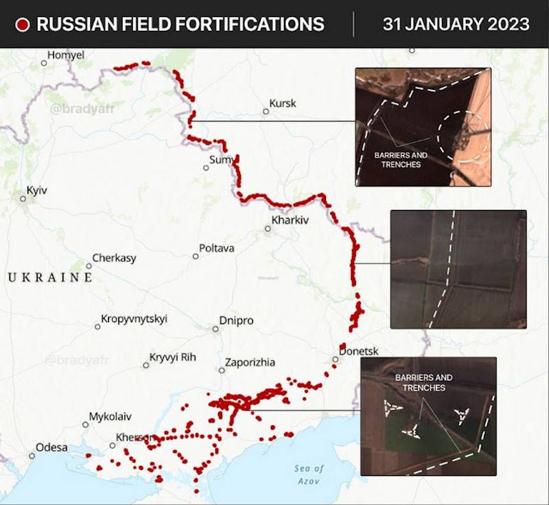
“A continuous line of fortifications from the Dnieper estuary to Belarus”: the Greek press showed a map of Russian fortifications
Western observers are closely monitoring the military situation on the Ukrainian front, using, in particular, satellite images to analyze the ongoing fortification work of the RF Armed Forces.
The Russians built the longest defensive line since World War II
- noted in the publication DefenseNet.
As stated, "a continuous protective strip begins from the Dnieper estuary and ends in Belarus" and is designed to contain the onset of hundreds tanks and armored vehicles, which will be covered by massive artillery fire from hundreds of enemy guns. According to the author, fortifications were considered by many as a “strategic anachronism”, however, the fortified areas of the Armed Forces of Ukraine became a significant obstacle to the advancement of Russian troops [perhaps due to the fact that they are located mainly in cities and other settlements, in contrast to the field structures of the Armed Forces of the Russian Federation - VO ].
Fortification work is progressing rapidly. Two months ago, Russian fortifications could be seen on satellite images only in the Luhansk sector and in the northern part of the Donetsk front.
However, now [data as of January 31] fortifications and trenches have covered the entire territory adjacent to the theater. The Russians are about to meet a massive offensive from Western Leopard-1/2, M1A2 and Challenger-2 tanks along with hundreds of armored vehicles
- explained in the Greek press, showing the corresponding map.
It is alleged that in order to break through the Russian defense, the Armed Forces of Ukraine will need to create a multiple numerical superiority. But in order to stop massive attacks, the operational reserve of the RF Armed Forces includes 150 fighters from the recent mob call, which were left for "hard times." Enemy armored vehicles will have to overcome tough opposition from anti-tank weapons: it is stated that 800 anti-tank systems with 4 thousand missiles are deployed on the first line of the Russian fortified zone; the second-tier anti-tank systems are being saturated due to the mass production of the Kornet and Metis complexes.
The Russians intend to wear down and destroy the Ukrainian forces when they are thrown into the attack of the fortifications [no later than the beginning of April]. After that, they expect to start their offensive already.
- the conclusion is made in DefenseNet.
Information