American magazine Wired: Soviet military cartographers failed to surpass anyone

144

After the collapse of the Soviet Union, military cards began to fall into the hands of Western collectors, which had never previously existed in the public domain, since they were classified. It turned out that they are much more accurate and detailed than any of their counterparts from other countries.

About this writes the American magazine Wired.


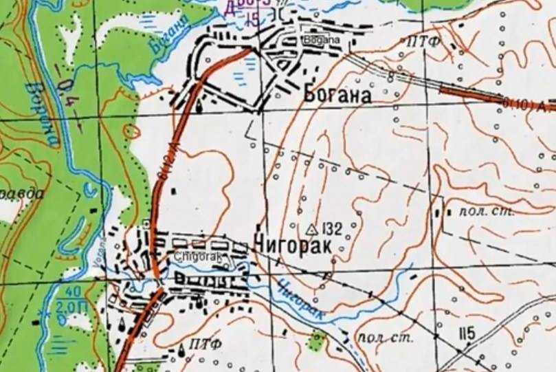
During the Cold War in the Soviet Union, the military compiled maps of cities and regions of various countries of the world. They indicated such details that could not be found on local maps. For example, using these cards, you could find the carrying capacity of bridges, the width of roads, types of industrial enterprises, and much more.

The author of the article, Greg Miller, believes that such cards would be invaluable if you are planning an invasion. But he thinks that their purpose is much wider, since information was also indicated that could hardly be useful to the military. For example, they were unlikely to find the location of bus stops in some Texas town.

Miller suggested that the purpose of these cards goes far beyond military interests. He believes that they performed for the Soviet leadership the function of something between the Google maps and Wikipedia, only on paper.

It is not known exactly how many such cards existed, but, presumably, the bill goes to millions.

It is not surprising that when the USSR stumbled and it was started to be pulled apart, enterprising foreigners began to buy up secret cards for nothing from individual, dishonest, Soviet troops. They were able to make good money on their resale, making this a real business. It was then that Soviet military cards became the standard for cartographers around the world. They could not be surpassed by anyone.

The director of the American company EastView Geospatial, specializing in the resale of secret cards made in the USSR, once spoke of Soviet cartography as follows:

Cartographic culture for Russia is like a wine culture for France.
144 comments
Information
Dear reader, to leave comments on the publication, you must sign in.
  1. -60
    31 May 2020 15: 10
    when the USSR stumbled and it began to be pulled apart in pieces, enterprising foreigners began to buy up secret cards for nothing from individual, dishonest, Soviet soldiers.

    If a person has nothing to feed his family and pay for housing, then why and for whom should he keep maps of foreign countries, for example?
    Especially if the top officials sold him and his Motherland entirely for "30 pieces of silver" !!!
    1. +68
      31 May 2020 15: 15
      Quote: Starover_Z
      If a person has nothing to feed his family and pay for housing, then why and for whom should he keep maps of foreign countries, for example?
      Especially if the top officials sold him and his Motherland entirely for "30 pieces of silver" !!!

      It was with such views and attitudes towards their homeland that the USSR also profiled!
    2. +37
      31 May 2020 15: 18
      What are you? this is generally called treason. in WWII, people also wanted to eat. had to surrender everything for this ?! you are carrying some kind of nonsense. no matter how the guidance comes before a conscience, we bear a personal answer.
      1. -1
        31 May 2020 17: 13
        Quote: carstorm 11
        What are you? this is generally called treason. in WWII, people also wanted to eat. had to surrender everything for this ?! you are carrying some kind of nonsense. no matter how the guidance comes before a conscience, we bear a personal answer.

        Only we have to bear a personal answer before the conscience ?! How much military equipment was abandoned in the countries of the former Warsaw Pact, in our former garrisons ?! Or all, to the screw was taken out ?! There was no secret or latest technology left there, to which, in Soviet times, Americans could only lick their lips ?! And if the equipment behind which the same conscripts were sitting and which was left behind, the conscripts had to drive under their own power to the Union, so that they would not get to the enemies - "partners" ?!
        And the leadership is of course okay, "videy pit" like what and how to do? That's right, it's like now - steal a bag of flour and get 5 years or embezzle a couple of billions in monetary terms, share and get house arrest!
        1. Aag
          +10
          31 May 2020 17: 56
          Yes, there are two big differences: to obey the orders of higher bosses (traitors), being bound by the Oath, the Charter of the USSR Armed Forces, and to take personal initiative, or, gentleness, in the sale of the Motherland ... Persian-speaking commentator, apparently, is not familiar with such concepts. due to age ....
        2. +7
          1 June 2020 00: 12
          Quote: Starover_Z
          Quote: carstorm 11
          What are you? this is generally called treason. in WWII, people also wanted to eat. had to surrender everything for this ?! you are carrying some kind of nonsense. no matter how the guidance comes before a conscience, we bear a personal answer.

          Only we have to bear a personal answer before the conscience ?! How much military equipment was abandoned in the countries of the former Warsaw Pact, in our former garrisons ?! Or all, to the screw was taken out ?! There was no secret or latest technology left there, to which, in Soviet times, Americans could only lick their lips ?! And if the equipment behind which the same conscripts were sitting and which was left behind, the conscripts had to drive under their own power to the Union, so that they would not get to the enemies - "partners" ?!
          And the leadership is of course okay, "videy pit" like what and how to do? That's right, it's like now - steal a bag of flour and get 5 years or embezzle a couple of billions in monetary terms, share and get house arrest!

          Briefly, military equipment in the Warsaw Treaty countries did not rush! Moreover, everything was exported! Of course, in addition to capital facilities! Personally, he took part in the loading of weapons and other equipment. For reference, the whole month the personnel worked as loaders, and then flew to the USSR with the entire regiment! Unfortunately, the Ukrainian SSR!
        3. -2
          1 June 2020 11: 24
          Quote: Starover_Z
          get 5 years or appropriate a couple of billions in cash, share and get a house arrest!

          or the post of head of Roskosmos
      2. -2
        1 June 2020 00: 25
        Sorry, but you are talking nonsense. In the Second World War there was a country of the USSR, yes, there is no doubt treason. But when the Union collapsed, there was no betrayal. The military were not only Russians, but also the remaining 14 republics. Well, we see now how they relate to us. So for them it’s not a betrayal, but revenge and a way to make money on it. But at the expense of the bus stops and the arrival time, it’s not like the military, how the special services used it (how to get there, how to get off, where to make an appointment, etc.) This is for the author of this article.
    3. -1
      31 May 2020 15: 28
      Now that everything is digitized,
      1. +3
        31 May 2020 15: 36
        paper will not be removed in any case. they did it and will do it. here it’s how it is done.
        1. +2
          31 May 2020 19: 49
          Naturally, what will Kroki do on the tablet, which can be bent at any moment or transfer data to third parties?
      2. +7
        31 May 2020 17: 47
        Quote: Civil
        Now that everything is digitized,

        The speed of the rivers, horizontal heights - too? I’m not talking about the width and material of roads, the carrying capacity of bridges, etc., etc. laughing
        1. -1
          1 June 2020 10: 06
          It is even easier to digitize
          1. +1
            1 June 2020 16: 56
            Quote: shkiper83
            It is even easier to digitize

            But for this you need to take somewhere the numbers. From old soviet maps? laughing
          2. 0
            1 June 2020 19: 28
            Go through the terrain, describe it, collect information. 3D cartography now provides excellent terrain (elevations); everything else requires a cartographer to work on the ground and with many sources.
    4. +10
      31 May 2020 15: 30
      If a person has nothing to feed his family and pay for housing, then why and for whom should he keep maps of foreign countries, for example?

      It's not about cards with printed objects. And about the quality itself.
      Here the Wired magazine is right - our topographic maps of the Soviet period are the best in the world.

      Yesterday I read Sergey Bolashenko’s blog, writes about the world's railways and travels cheaply.
      He compared different maps for travel, his conclusion:

      Soviet cartography is without a doubt the best in the world. Americans do not know how to make cards in the normal way! Local (issued in the USA) maps to the territory of this country are terrible in quality. Like all other foreign cards.

      I recommend for those who want to see the real America (uzhos!).
      http://infojd.ru/dop/poezdka2014us-1.html

      The text contains links to maps of the Soviet period of issue.
      1. 0
        31 May 2020 15: 34
        they are still excellent. Even in the nineties, topographers were guarded at any level.
      2. +9
        31 May 2020 16: 11
        One quality is not enough they still need to be updated regularly and high-quality but outdated cards often do more harm to the army than good.
        1. +3
          31 May 2020 22: 11
          Quote: BARKAS
          One quality is not enough they still need to be updated regularly and high-quality but outdated cards often do more harm to the army than good.

          I had a chance to use such maps, on which, over the course of many years, the indicated roads and lodges were already overgrown with forest, and settlements disappeared. Where the ferry crossing was indicated, bridges have been built for a decade and a half, etc. The only thing that remained impeccably relevant was the railways, and, as mentioned above, the current speed, depths, characteristics of river beds, passability or impassability of swamps, heights, etc. Apparently for this reason, for most cards, the secrecy label was lowered from "secret" to "DSP" back in the mid-90s.
          1. +2
            1 June 2020 09: 03
            And here I will argue with you: there were detachments of military topographers in the SA who wandered around the country and found changes and made them into the current maps, and then republished them with changes. We, the builders, handed over executive schemes to the city geodesy departments for special and important structures, which, in turn, sent the changes to the USSR GUGK and collected them, summarized them, and, I think, collaborated with the USSR Ministry of Defense. All our civil maps were labeled "DSP", as well as stock materials on topogeodesy. As it was in the USSR Ministry of Defense, I don't remember any more - about thirty years have passed since the time of service. So the changes were made - that's for sure!
          2. +1
            1 June 2020 12: 19
            Quote: Nyrobsky
            Where the ferry crossing was indicated, bridges have been built for a decade and a half, etc. The only thing that remained impeccably relevant was the railways, and, as mentioned above, the current speed, depths, characteristics of river beds, passability or impassability of swamps, heights, etc. Apparently for this reason, for most cards, the secrecy label was lowered from "secret" to "DSP" back in the mid-90s.

            I don’t know if you served, but each officer, starting with the commander of a separate company and above, had his own work card, with which he went out at least once a month for reconnaissance at the deployment site (in some structures this was done by NS or the first deputy) , and where all the changes that occurred on the ground were made. At least it was in the GSVG in my time. Therefore, there is no need to exaggerate about the cards - those who were supposed to have carefully worked out their cards, and this will be confirmed by those who served in the army for many years.
            And the neck was removed because it did not make sense to keep it when a huge number of our cards turned out to be in the Baltic republics and they were handed over to NATO. Why then keep the vulture, especially since the loss of a secret card, even without the situation, caused a penalty.
            1. 0
              1 June 2020 18: 55
              A colleague, his own work card in the SA was starting with the commander of a tank / infantry platoon. lol We had a reconnaissance 1 time in half a year. And they usually clarified the map through the AFS or satellite, no one went once a month. I don’t remember the frequency, but every time before the "drop-in" on the exercises - for sure. drinks
              1. +1
                1 June 2020 19: 13
                Quote: Doliva63
                A colleague, his own work card in the SA was starting with the commander of a tank / infantry platoon.

                I was not talking about this card, but about those with whom they work in the "dark room", if you know what it is. A strictly limited circle of persons is admitted to it.
                Quote: Doliva63
                And they usually specified the map through the AFS or satellite; no one traveled once a month.

                I’m afraid that you simply don’t know how one day a week your NS (or commander) worked with combat readiness documents, and where he went with them. These events were not advertised in order to hide genuine deployment areas, which only the commander and NS knew about.
                1. 0
                  2 June 2020 19: 54
                  Quote: ccsr
                  Quote: Doliva63
                  A colleague, his own work card in the SA was starting with the commander of a tank / infantry platoon.

                  I was not talking about this card, but about those with whom they work in the "dark room", if you know what it is. A strictly limited circle of persons is admitted to it.
                  Quote: Doliva63
                  And they usually specified the map through the AFS or satellite; no one traveled once a month.

                  I’m afraid that you simply don’t know how one day a week your NS (or commander) worked with combat readiness documents, and where he went with them. These events were not advertised in order to hide genuine deployment areas, which only the commander and NS knew about.

                  There, at 20 GVOA GSVG, we had one goal - West Berlin. Our task was to "block" the American "Rangers" in the PPD. Not for scouts "work", but where to go. Every six months we went to see them to see what had changed. And the "true areas of deployment" were of little concern to us, since in any case, a side was waiting for us where we had never been. At 8 GvOA, yes, everything was somehow cloudy, I don't even remember much of what and how. It seems that the 11th OBRKP was looming somewhere. And at the time of Brigadier General Rogers' 20 Guards, I remember the beginning of the BRA's reconnaissance in 89. There are even pictures of how they drank vodka in a tent laughing drinks
            2. 0
              1 June 2020 19: 11
              Quote: ccsr
              At least it was in the GSVG in my time. Therefore, there is no need to exaggerate about the cards - those who were supposed to carefully worked out their cards, and this will be confirmed by those who served in the army for many years.

              Nobody exaggerates. You are talking about the times when the GVH existed, but meanwhile, since the Warsaw Treaty was liquidated, a quarter of a century has passed. I don’t argue, at that time the maps were quite complete and accurate, but I’m talking about a much later period indicating that -
              I used to use such cards, on which, after many years, the indicated roads and lodges have already been overgrown with forest, and settlements have disappeared.
              A quarter of a century for cards is also not a weak period, after which serious adjustments are necessary.
              Quote: ccsr
              And the neck was removed because it did not make sense to keep it when a huge number of our cards turned out to be in the Baltic republics and they were handed over to NATO.
              Each district had its own maps. In the Baltic States, there were no SKVO, SVO, SibVO cards, including the NATO members, of course, raped something, but fortunately, not all.
              Quote: ccsr
              Why then keep the vulture, especially since the loss of a secret card, even without the situation, caused a penalty.
              I do not know how the transfer of the liquidated military unit to local aborigines was carried out, but probably the employees of the secret units destroyed the "secret" under the act, or took it out. Although a lot of these cards remained at the military registration and enlistment offices. But what can we say about maps, if in all the seceded republics there were cipher organs, with equipment and key attachments that were in the unified system of the USSR. Then, in general, with the demolition of the USSR, along the way, they broke a lot of firewood, which went to the NATO and Western sp. Services for the ball.
              1. +2
                1 June 2020 19: 52
                Quote: Nyrobsky
                Each district had its own maps. In the Baltic States, there were no SKVO, SVO, SibVO cards, including the NATO members, of course, raped something, but fortunately, not all.

                This is not entirely true, because everything depended on the kit ordered at the district warehouse of the topographic service. I got everything from mine, right up to Moscow, when I returned. These depots were in every district, so believe me, the NATO troops got everything that was there.
                Quote: Nyrobsky
                But what can we say about maps, if in all the departing republics there were cipher bodies, with equipment and key outfits that were in the unified system of the USSR.

                Here I am about the same thing - there were no topographic maps to the district warehouses, because the trains had to be pulled in there in order to take everything out.
                Quote: Nyrobsky
                Then, in general, with the breakdown of the USSR, along the way, they broke a lot of firewood, which fell to the NATO members and the Western intelligence services for a ball.

                That is exactly what happened. So also some of our former colleagues in the service of NATO fellows — they laid all out to curry favor.
                1. +2
                  1 June 2020 21: 43
                  Quote: ccsr
                  That is exactly what happened. So also some of our former colleagues in the service of NATO fellows - they all laid out to curry favor.

                  This is yes. I remember how some of our officers after the collapse of the USSR departed to their republics, but after some time, some of them returned back, to serve, but already in positions lower than those that they held before the transfer, and not in command but in units. But this is the third thing ... It just so happened that during special events in the northern taiga, at the beginning of the 2000th thousandth, I had the opportunity to use a map that indicated that it was compiled on the basis of a 1984 survey. We walked along the north-south quarter, and reached the intersection of the south-west quarters. On the General Staff map, the quarter was indicated as a straight line, and we came to a standstill. Having worked from the point of interlocking of quarters in different directions, we found a shift of quarters of meters by 70-100 to the east, and continued to move. When reconciling the map with the tourist, this offset of the quarters on the tourist map was indicated. This suggests that there was no docking (reconciliation) of cartographers with forest managers, and forest managers, in my opinion, did not work at all after the collapse of the USSR. the support of neighborhoods and the restoration of quarterly columns, people supported themselves in their hunting areas, because without knowing the quarterly grid in those places you can get lost for one or two. These same people have kindly provided us with information about their huts and borrowings. The closer to Russia the smaller the quarter, the farther to the North the more - in the Kirov region 1kmX2 km, Komi from 1X2 to 2X4, Yamalo-Nenets Autonomous Okrug from 2x4 to 4X8. In general, this topic is very extensive both in theory and in practice. Let's end with this hi
                  1. +2
                    2 June 2020 11: 42
                    Quote: Nyrobsky
                    This suggests that there was no docking (verification) of cartographers with forest managers, and forest managers, in my opinion, did not work at all after the collapse of the USSR, because the support of neighborhoods and the restoration of quarterly columns, people supported themselves in their hunting areas, because without knowing the quarterly grid in those places you can get lost for one or two.

                    This is not surprising, because in the nineties the General Staff was shrinking, and the Military Topographical Directorate, which was not even the Main Directorate, also suffered losses, which naturally affected the quality of work in terms of updating maps. In a word, there was such a mess that there was no time for lumberjacks, that's why you saw what it led to already on the spot.
      3. +8
        31 May 2020 16: 17
        About this we were still authoritatively declared at a military school. And, as proof, they gave me a look at the maps of the FRG army and the American one. Honestly, at first glance it was generally not clear what and where - the drawings of children are more accurate and understanding!
      4. +1
        31 May 2020 18: 09
        My schoolmate had a dad who was a simple military topographer, so he has all his biography before the army - Mexico, USA, England. laughing
    5. +22
      31 May 2020 15: 38
      So we lived to the point where people are completely unashamed in their blue eyes talking about the betrayal of the country as something completely normal and with a bunch of exclamation marks ..
      1. +6
        31 May 2020 16: 01
        Late now, the hairs to tear. This is a lesson for the future.
        Who will learn it and how is this a question?
    6. -3
      31 May 2020 17: 08
      Varning !!! - "Consumer Sapies" detected !!! Alarm !!!
      1. +3
        31 May 2020 17: 13
        Cards, cards ...

        On the online service map https://bestmaps.ru/ the front line in the DNI is marked almost as the state border.
    7. +6
      31 May 2020 18: 47
      Quote: Starover_Z
      If a person has nothing to feed his family and pay for housing, then why and for whom should he keep maps of foreign countries, for example?
      Especially if the top officials sold him and his Motherland entirely for "30 pieces of silver" !!!

      You know the impression that you share your life experience and how you justified yourself ... negative
    8. +3
      31 May 2020 19: 12
      Quote: Starover_Z
      If a person has nothing to feed his family and pay for housing,

      Most of the cards were not sold - they were just given. Colleagues from the United States came to the headquarters of the Northern Fleet, saw a map of salinity profiles of the Arctic Ocean, were surprised, asked and received as a gift. And on this map, a submarine can determine its position up to ten kilometers, simply by taking a sample of the sea water. Gore-Shevardnadze line: asked - please. Blueprints for the Yak-141 - why the fuck we need them! "Wasp" did not fall under the INF Treaty, the Americans were going to bargain - our "negotiator" entered it directly into the draft, without consulting anyone. Is it a pity, or what?
      A complex of Soviet inferiority and complete infantilism in economic and military activities. Third-generation lackeys, constantly looking for a master.
      1. 0
        1 June 2020 12: 37
        Quote: Oo sarcasm
        Most of the cards were not sold - they were simply presented. Colleagues from the USA arrived at the headquarters of the Northern Fleet, saw a map of the salinity profiles of the Arctic Ocean, were surprised, asked and received as a gift.

        Do not drive the wave - after the collapse of the USSR, a huge amount of our classified materials appeared both in the Warsaw Treaty countries and in the former Soviet republics. Are you sure that the Americans did not already have this card, from the same Germans or our Baltic states from naval bases? There was a list of secret equipment and documents that the NNA of the GDR was obliged to return to us, and they did it, that's just what kind of stamp can such materials have, if we naturally assumed that copies were already taken from them.
        But I do not deny that some of our fools did give permission to transmit to our enemies what was of interest to them. But the matter is not only in lackeys, but in the fact that some smart people have already realized that it makes no sense to keep in secret what has already come to our opponent, that’s why you don’t have to cut everyone under one comb.
    9. +1
      31 May 2020 21: 22
      If a person has nothing to feed his family and pay for housing, then why and for whom should he keep maps of foreign countries, for example?
      Especially if the top officials sold him and his Motherland entirely for "30 pieces of silver" !!!


      A. A ready traitor, and he has already come up with an excuse.
    10. +2
      1 June 2020 07: 28
      There was nothing to eat for those officers from the Pacific Fleet Command who sold the Minsk TAKR and Novorossiysk TAKR for less than the price of scrap metal and transferred them to China and Korea without removing the secret equipment, and without even removing the secret documents from the safes .. ...
    11. 0
      1 June 2020 07: 40
      interesting .. such parents will be sold to anyone!
    12. 0
      1 June 2020 15: 17
      Quote: Starover_Z
      If a person has nothing to feed his family and pay for housing, then why and for whom should he keep maps of foreign countries, for example?
      Especially if the top officials sold him and his Motherland entirely for "30 pieces of silver" !!!

      That is, in your opinion, everything is sold and everything is bought. Do you yourself understand what utter chuhnina they scratched here?
      1. 0
        1 June 2020 19: 09
        Quote: NEXUS
        Quote: Starover_Z
        If a person has nothing to feed his family and pay for housing, then why and for whom should he keep maps of foreign countries, for example?
        Especially if the top officials sold him and his Motherland entirely for "30 pieces of silver" !!!

        That is, in your opinion, everything is sold and everything is bought. Do you yourself understand what utter chuhnina they scratched here?

        "Everything in this market is for sale ..." Berkeley, in my opinion, the century before last. What did you want from capitalism? But this - "chukhnya", interested me. Where did they get it, I wonder?
        1. 0
          1 June 2020 20: 15
          Quote: Doliva63
          But this - "chukhnya", interested me. Where did you get it, I wonder?

          Personal nano-invention. hi
          1. 0
            2 June 2020 19: 56
            Quote: NEXUS
            Quote: Doliva63
            But this - "chukhnya", interested me. Where did you get it, I wonder?

            Personal nano-invention. hi

            Come on. Strugatsky, go and read it? laughing
            1. +1
              2 June 2020 21: 31
              Quote: Doliva63
              Strugatsky, go and read it?

              Sometimes ... but my technology)
              1. +1
                3 June 2020 22: 01
                Quote: NEXUS
                Quote: Doliva63
                Strugatsky, go and read it?

                Sometimes ... but my technology)

                Clear, quiet schizophrenic, like me drinks
  2. +5
    31 May 2020 15: 16
    About maps and strategy))
    1. +2
      31 May 2020 18: 42
      Thank! Pleased ...
  3. +19
    31 May 2020 15: 19
    Quote: Starover_Z
    when the USSR stumbled and it began to be pulled apart in pieces, enterprising foreigners began to buy up secret cards for nothing from individual, dishonest, Soviet soldiers.

    If a person has nothing to feed his family and pay for housing, then why and for whom should he keep maps of foreign countries, for example?
    Especially if the top officials sold him and his Motherland entirely for "30 pieces of silver" !!!

    and someone else, under equal conditions, did not sell! I know both these and these! So the first ones were scum, which were covered by conditions. And the second were People. And they got out in other ways, but they did not sell their homeland.
  4. -6
    31 May 2020 15: 22
    Only ordinary people, on the terrain, were guided by a bundle of White Sea. Well, or on a school atlas.
    1. +7
      31 May 2020 15: 50
      Don't lie, Alexander. There were excellent maps for tourist, automobile, sports. The GShs differed from the maps only in "white spots" and some shift of coordinates, so that the "points" were not displayed. I remember very well both "civil" and military maps (and used for command and control with drawn points of nuclear strikes, etc.) Both civilian and military maps could be perfectly oriented, and going to pick mushrooms they often took these maps.
      1. +4
        31 May 2020 16: 22
        You can have a little bit of fun. There were various atlases. But here’s more about a ten-page layout as it didn’t come across at that time. The incident was in the year 89. In the UAZ, we reached the place of the future pontoon crossing, mid-June, the flood is already in decline. A Muscovite arrives, a crawling Muscovite driver dumbfounded at a raging stream, 150 meters wide and in an atlas. Suitable asks, am I right ?, right. Where is the road? no? But here it is! so go. According to the atlas, the ferry operates from the first of April to December. And the ice drift happens even until June! And another month the water is raging.
        1. +3
          31 May 2020 16: 26
          Here I agree with you laughing
          With "fords" and "crossings" this happened, and not very rarely. What to do, the calculation was not for "Muscovites-UAZ", but for armored vehicles laughing
          1. Aag
            +4
            31 May 2020 18: 26
            Well ... Rather, everything was designed for the competent (in the sense of cartography, as the user is now saying): I could be wrong, but explanations went to a normal map (I hope the specialists will correct it), - the speed of the current, the depth (ford) in different seasons (according to the results of many annual observations) ... 1st: if we take, for example, the Siberian rivers, then the water flow can change by orders of magnitude within a few hours! Either you can calmly cross in swamps, then, at the same depth The speed of the stream, the width of the floodplain ... Again, I hope, the experts will chew the 2nd: the rapid climate change. No, I am not a supporter of G. Tumberg. But, in micro examples (up to a separate vegetable garden ), the tendency is very clear. I do not take into account other aspects of the problem, but the massive deforestation, strongly, and, most importantly, little predictably, and very sharply, affects the "water circulation in nature" (IMNIP: natural history textbook 4th class of the USSR secondary school).
            1. +2
              31 May 2020 18: 32
              I also partially agree) We have the Serga River. In summer, you can go on foot almost everywhere. In spring, the water level rises by an average of 3 meters. And this is with a river width of 10-20 meters. Chusovaya in the spring and rises 7 meters. This is me, as a raftsman says. But the cards with all the legends could not take into account that last year the flood was at the end of May, and this one at the end of April. So guess when to get there. laughing
              1. Aag
                +1
                31 May 2020 19: 09
                I agree.
                The river "pereplyuyka", - we ford crossed (Tunkinskaya valley), - the next day, - the Belarus tractor came up to pull out the drowned UAZ, the Emergencies Ministry pulled up, - the bodies of two boys were looked for, - the horses went upstream. The landscape changed (for night) dramatically: although, the width, the speed of the river, almost the same ... But boulders (30-60 kg), the trunks of the trees brought! Impressed ...
                Therefore, (there was still access to normal maps, I did not find any contradictions). Apparently, then "they were responsible for the bazaar" ...
        2. 0
          31 May 2020 19: 44
          Quote: Free Wind
          There were various atlases

          In atlases and civil maps I saw one road that never existed at all, sometimes they still ask about it. Also, the marked cattle drive path, where it could not exist in principle, has not yet been invented by the propeller for donkeys. Another example, find the Soviet physical map of the world, where the highest point of the Kun-Lun mountain system in China was Ulugmuztag mountain, supposedly 7723 m. On new maps, this mountain 6900 + I don’t remember exactly how much, it's its real height.
      2. +1
        31 May 2020 18: 15
        The civil maps were so-so, the Karelian lakes did not match either along the coastline or in the direction of the cardinal directions, the shift was by degrees
      3. +1
        31 May 2020 18: 28
        I remember the tourists who walked on German maps of the Second World War. They were accurate enough in the details. Domestic cards of this level were not available.
        1. +1
          1 June 2020 09: 11
          They said that the German maps had our geodetic base, so I don’t know, I don’t know. And as for the availability of our cards - why did the people have to have them? There were tourist and geographical maps. And go on the artillery two-layer mushrooms? Correctly and did that did not give to the people! Extra people do not need.
  5. -4
    31 May 2020 15: 24
    After the collapse of the Soviet Union, military cards began to fall into the hands of Western collectors, which had never existed before in the public domain, since they were classified

    Fritz in June 1941, too, praised our cards ... But in our troops this was not.!
    1. -13
      31 May 2020 15: 35
      Oh. well enough! Seriously. the war is won. in full. whoever said anything on the Reichstag, the banner hung if they forgot.
      1. The comment was deleted.
        1. -13
          31 May 2020 15: 57
          I'm wildly sorry, but maybe it's worth sobering up and reading carefully?
        2. +11
          31 May 2020 16: 03
          on the Reichstag a banner hung if they forgot

          And we Russian fluttering

          You both, the same Russians as I am a mohawk .. First and most importantly, the flag was installed on the Reichstag building, and it was "hanging" or "fluttering", of course you know better the verbiage.
    2. -3
      31 May 2020 15: 55
      Quote: Lepilo
      Fritz in June 1941, too, praised our cards ... But in our troops this was not.!
      Why, did you use a pack of Belomor-Canal to counterattack? belay
    3. -1
      31 May 2020 16: 25
      The Fritz had just the same outdated maps, almost of imperial times. And flies about this often.
    4. +1
      31 May 2020 17: 58
      Fritz in June 1941, too, praised our cards ... But in our troops this was not.!
      Originously. And where did the Fritz then take our cards do not tell me? Wait, I'll guess. The chain dogs of Stalin from the NKVD did everything in their power to prevent the distribution of cards to the red commanders, and when fleeing they threw entire warehouses with cards without even bothering to burn them. Guessed?
      1. -2
        1 June 2020 07: 56
        White officers of a ten-page card were dragged by tons after the revolution. Villages and houses have changed, the landscape is not.
        1. +1
          1 June 2020 08: 36
          The conversation was about the 41st year. And decors are still staff cards.
        2. +1
          1 June 2020 09: 24
          [quote = Free wind] Villages and houses have changed, the landscape is not
          As a builder (a little military, but all my life as a civilian) I will say this: depending on what period of time - both buildings and landscape change. So, if the former whites brought cards from the front in 1918, then twenty years later they needed them except for wallpapering or wallpapering so that it would not be boring to sit there! And over fifty years, the changes are generally enormous, both in the European part of the USSR and in the Asian.
          1. 0
            1 June 2020 09: 54
            It's about 1941. The landscape hasn’t changed much, well, there were simply no large-scale changes, DneproGES is probably the exception, aerial photo data were superimposed on it. According to Rudel's memoirs, having studied the maps, I knew the area better than the locals, because I also knew the location of military facilities.
            1. +1
              1 June 2020 10: 53
              And I'm talking about 1941 ... Yes, in the European part of our country, such changes have occurred that other countries never dreamed of, and they took centuries to do it. We from the agrarian Republic of Ingushetia became the industrial USSR! Cities, towns, infrastructure, etc. have appeared. Please compare the lengths of roads and railways at the end of February 1917 and at the end of May 1941. Here is the answer. But any roads are not just roads - this changes the topogeodesy of a strip with a width of at least 100 meters, and for a maximum - see the executive documentation of the constructed road, plus gas stations, bridges, tunnels, shops, pubs, and so on. The "zero balance" method is correct, but not for this case. And how many factories, factories, engineering networks and structures have been built during this time. So the changes during those twenty interwar years were enormous. We never dreamed of this in 1970-80, although we did not wipe our pants with chairs ... Stalin's industrialization is not what it was with us later.
      2. 0
        1 June 2020 09: 15
        Suvorov remembered? So you can’t believe a single word !!! Although ... like he wrote then about tons of maps of neighboring countries, thrown by ours near the border. I don’t remember exactly. Correct if not so.
        1. 0
          1 June 2020 09: 20
          After reading the first book of Suvorov, I never read his masterpieces anymore, so I can't say anything about the tons of maps of neighboring countries thrown by ours near the border, since we were not going to attack Germany, which means there is nowhere to get tons of maps. But in the second half of 41, we had problems with topographic maps. But at the beginning of the war there were no problems with them.
          1. 0
            1 June 2020 09: 37
            Maybe so! I will not argue.
    5. -1
      1 June 2020 16: 43
      The problem was that there were cards, and there were supplies of cards, but everything died in the first month of the war.
      It was problematic to print quickly such volumes + all paper raw materials were spent on the manufacture of gunpowder
  6. +15
    31 May 2020 15: 28
    and Putin said only galoshes could do, strange ... lied?
    1. The comment was deleted.
    2. -11
      31 May 2020 15: 46
      But what did Putin really say? And he said this: "... no one needed everything that we produced. Because nobody bought our galoshes, except for an African who needed to walk on hot sand
      stop turning over obvious and accessible things to everyone. it's stupid
      1. 0
        1 June 2020 11: 59
        Has anyone tried to walk on the hot sand in galoshes? Legs and galoshes will fall off. The skin peels off at least and the nails fall out. And so the galoshes were very common upper shoes and the same in Europe .. Until a certain point in the development of industry. When new materials appeared. The shoes were leather. and often from expensive matter. Galoshes were worn to protect the main shoe, from external factors. Having entered the house, galoshes were removed, and they were slandering around the house already in basic shoes. Mom Lesha bought, excellent galoshes, beautiful, shiny, just like real ones.
        1. -1
          1 June 2020 16: 48
          Quote: Free Wind
          Has anyone tried to walk on the hot sand in galoshes? Legs and galoshes will fall off. Skin peels off at least and nails fall out

          Aha fellow .... you tell the Central Asians, they will be extremely surprised .....
          And the Afghans, they will also be a surprise - that the legs fall off
          Well, you can also for everyone who wears ichigi - in fact, you have the very galoshes of only thin skin .....
          They all laugh at you
          1. 0
            1 June 2020 17: 01
            Of course they will laugh at me. Whoever fires, walks in the sand. In the heat, you need to sit in the shade, drink tea, smoke a hookah .. It will become cooler, you can walk. Moreover, they have either Ramadan, then Ramadan, or Kurban Bayram. In short in the heat to walk nefig, it is necessary to go on pickups, with machine guns. drinks
            1. -1
              1 June 2020 17: 17
              Quote: Free Wind
              In short in the heat to walk nefig, it is necessary to go on pickups, with machine guns.
              -who ride on pickups-they stand lol
    3. +7
      31 May 2020 15: 59
      Quote: Alexey from Perm
      and Putin said only galoshes could do, strange ... lied?

      No, I didn’t lie. They did it. Now we do not. wink
    4. 0
      31 May 2020 18: 47
      No! He - misinformed the enemy!
    5. Aag
      0
      31 May 2020 18: 50
      You know, I was a "Putinist" for a long time ... Foam at the mouth ... (I can present arguments to IMHO). After the pension reform ... a brain rupture (argumentation is more important), - then, - like a snowball!
      About "galoshes" - a slap in the face of everything ... and not even everything Soviet, but the People who worked at that time (and very successfully, in the sense of the country's success).
      I'm not lying, I started a notebook (for myself, for opponents): + - a new "system". I think that thinking people were engaged in something like this. BUT, mother of a dog! How slippery they are! To give out the USSR developments (for some, who are mad, sorry,) for BREAKTHROUGH. (?)
  7. +7
    31 May 2020 15: 36
    For example, they were unlikely to find the location of bus stops in some Texas town.

    But how convenient. I parked some “Carnation” at the bus stop and count, got in a top-tied position :))
    1. +2
      31 May 2020 18: 48
      From the language removed!
  8. +1
    31 May 2020 15: 55
    For some reason the "probable partner" began to praise us))) And how are things with us now with the cards? Who knows? Electronic maps are good, but paper ones don't need a battery and a battery ... I'm talking about those who are in the field, not in the control room. The rocket can be "sent" once and on the electronic map, but what about the platoon, company commander, battalion commander and infantry regiment ???
  9. +2
    31 May 2020 15: 55
    The American said very well about our cartographic culture.
    In some cases (if not often), distortions were deliberately introduced into topographic maps, which also indicated our high culture of secret office work.
    1. +1
      31 May 2020 16: 23
      Quote: bober1982
      The American said very well about our cartographic culture.

      Those who worked with the maps knew very well that they are excellent, even those related to Europe.
      Quote: bober1982
      which also said about our high culture of secret office work

      I found a time when the neck was quickly reduced to the General Staff maps, but this was due to the collapse of the USSR, when the neck did not make sense, because huge warehouses of topographic property remained on the territory of the former post-Soviet republics and almost immediately the NATO began to have access to them.
      1. 0
        31 May 2020 16: 31
        Quote: ccsr
        I found a time when the neck was quickly reduced to the General Staff maps, but this was due to the collapse of the USSR

        The vulture of secrecy began to be removed during the perestroika years, carefully and gradually.
        With the collapse of the Union, I agree, there was a sharp collapse, everything was declassified.
        1. +4
          31 May 2020 16: 47
          Quote: bober1982
          With the collapse of the Union, I agree, there was a sharp collapse, everything was declassified.

          I still have several of them with a signature stamp that I took as a keepsake, especially since they were much better than those published in car atlases.
          1. +3
            31 May 2020 18: 01
            Quote: ccsr
            Quote: bober1982
            With the collapse of the Union, I agree, there was a sharp collapse, everything was declassified.

            I still have several of them with a signature stamp that I took as a keepsake, especially since they were much better than those published in car atlases.

            What could be taken in secret and not returned? recourse
            1. +1
              31 May 2020 18: 29
              These cards were no longer kept in secret, and the secrecy stamp on the card sheet itself was preserved, or it was smeared.
              1. +2
                31 May 2020 19: 45
                Quote: bober1982
                These cards were no longer kept in secret, and the secrecy stamp on the card sheet itself was preserved, or it was smeared.

                By the way, if not in secret, then where? With me, all the cards went through it, so I’m not in the know.
                1. 0
                  31 May 2020 19: 56
                  Quote: Doliva63
                  By the way, if not in secret, then where?

                  Yes, in secret, everything is correct, I forgot.
            2. +1
              1 June 2020 09: 28
              They took everyone who had access - we have two sheets of General Staff "Ankara" and "Paris" at home. And the stamp is not smeared. And who brought them to me, I don't even remember ...
            3. +1
              1 June 2020 12: 00
              Quote: Doliva63
              What could be taken in secret and not returned?

              The neck was removed from them, and they were kept in our storage of cards unclassified as a consumable. So in Wünsdorf at the headquarters this was not a problem - there the consumption of cards was such that the head of the warehouse gave them to me without any consideration. When I was returning from the GSVG, I needed these - I was leaving in a Zhiguli and a good map was required on the road. They would still have to be destroyed, because not everything was subject to delivery to the group warehouse of topographic maps.
              By the way bober1982 wrote everything correctly -
              These cards were no longer kept in secret, and the secrecy stamp on the card sheet itself was preserved, or it was smeared.

              We didn’t even cover up the neck - if I find it, I’ll find one and do a scan.
              1. 0
                1 June 2020 17: 00
                "When I was returning from the GSVG, I needed those like that - I was leaving in a Zhiguli and a good map was required on the road."
                I was also replaced from the Group "on my own", but I managed with a German tour card - did not disappoint laughing
          2. Aag
            +1
            31 May 2020 19: 22
            Well, do not compare civil cards with ... others.
            1st: the coordinate grid was either missing or distorted. Objects of "some significance" were not specified.
            And further! I want to pay tribute to our cartographer, because they did more than the "competitors" could do with great technical financial capabilities ...
            However, everything, as always ...
  10. +8
    31 May 2020 15: 57
    And tovarisch Taburetkin was one of the first things to do - the sale of a military topographic institute with a printing house. "Why?" - said the clever creature: "We have JPS!" And now there is no one to print these maps for the RF Ministry of Defense, and in warehouses in units "suddenly" a shortage of sheets of some regions began to be organized ...
    1. +3
      31 May 2020 16: 15
      Give me my Soviet secret card
      cities and surroundings and I will not give you even a penny.
      Everything has changed beyond recognition - the wrong thing has not happened
      that stops - factories and airfields, and roads
      half on the contrary, and even there is no passage at all. At that
      the same time we’ve set up a new one, including roundabouts
      roads, roads through previously non-traveling beams
      between neighboring housing estates. About infrastructure
      generally silent, there were factories, steel malls, markets, technology parks.
      There were fields and rivers, closed cottage towns became
      with temples, towers, pools and racetracks.
      1. +1
        31 May 2020 19: 09
        Aw, well done! Let the adversary get lost!
      2. +5
        31 May 2020 19: 16
        Quote: Kushka
        Give me my Soviet secret card
        cities and surroundings and I will not give you even a penny.
        Everything has changed beyond recognition - the wrong thing has not happened
        that stops - factories and airfields, and roads
        half on the contrary, and even there is no passage at all. At that
        the same time we’ve set up a new one, including roundabouts
        roads, roads through previously non-traveling beams
        between neighboring housing estates. About infrastructure
        generally silent, there were factories, steel malls, markets, technology parks.
        There were fields and rivers, closed cottage towns became
        with temples, towers, pools and racetracks.

        Hydrography, elevations, outstanding landmarks also changed? From the first lessons on topography, it was hammered into the head that you should always pay for the year of publication (revision) of the map and make adjustments for human activity and natural factors. No cartographic service in the world is able to make changes to cartographic products online.
        1. Aag
          +2
          31 May 2020 21: 10
          Regarding the speed of making changes ... I can look at Google maps with a lag from a week to a month when I closed the roof in the garage. Apparently, we need to evaluate the number, quality of satellites in orbit ... This is not to mention the number of domestic assets officials abroad ...
          1. 0
            1 June 2020 19: 14
            in the year 2015, they wrote it in Google so that they would map a street in the Solntsevo-Peredelkino area, it had a different name for them. They changed a maximum of 3 days
        2. 0
          31 May 2020 22: 31
          The author of the article somehow particularly clicked on bus stops.
          Hence my comment.
          PS hydrographic objects can also be added to
          stops — some not at all, others changed
          beyond recognition.
  11. BAI
    +4
    31 May 2020 17: 46
    Military maps are outdated and have not been updated for a long time. We went camping. Had access to private cards. There is a road on the map. In life, she has long been gone.
    1. +4
      31 May 2020 18: 00
      Quote: BAI
      Military maps are outdated and have not been updated for a long time. We went camping. Had access to private cards. There is a road on the map. In life, she has long been gone.

      It's about cards at that time, then everything coincided smile
    2. +4
      31 May 2020 19: 20
      Quote: BAI
      Military maps are outdated and have not been updated for a long time. We went camping. Had access to private cards. There is a road on the map. In life, she has long been gone.

      It is not enough to have a card in hand, you still need to be able to read it. And not only what is painted but also written. Yes
  12. +3
    31 May 2020 18: 26
    Yes, then it was. What cannot be bought from the general, it was possible to buy from the ensign. It's a pity! No wonder. There was someone to take an example from. Bastard, Kozyrev himself in all traded military secrets.
    1. +3
      31 May 2020 18: 53
      Quote: Valter1364
      What cannot be bought from the general, it was possible to buy from the ensign.

      In 1985, at the Military Department, Comrade Captain once told us: "A warrant officer serves as long as his hands are worn."
      I still remember this phrase - such a life-affirming force in it, such a flight of thought!
  13. +1
    31 May 2020 18: 50
    The author of the article, Greg Miller, believes that such cards would be invaluable if you are planning an invasion.
    And for the actions of aviation and RDGs, one would think that the maps of our territory were less informative ...
    For example, they were unlikely to find the location of bus stops in some Texas town.
    For orientation on the terrain and establishing your location, without any "space priblud", every little thing is important
    1. Aag
      +1
      31 May 2020 19: 58
      Paper, apparently (IMHO) -Rulit! (Without space stray): I have a gluing, black and white, 2 by 3 meters (scale, worthy), - was ordered during the collapse, for hunting (the area of ​​firing aircraft, - polygon) According to some indicators, it’s more informative than maps, Google’s Meps satellite is more informative than maps.
      By the way, or rather, quite inopportunely, the informativeness of the maps available in the public domain is striking ... I look at the Google satellite, and I see mushrooms I picked up, where the hazel grouse shot. ") ... On the other hand, as already written here, the time factor: the following example, already long-standing.
      1. Aag
        +2
        31 May 2020 20: 22
        We leave for reconnaissance. The commander of the rocket regiment (the commander of the missile regiment of the Strategic Missile Forces) shows the KGPP (the commanders of the preparation and launch groups) their real points of deployment, launch. Without violating the 010th Order, I dare to report on the article. And there, in the field, in an island of the forest where they liked to hide the "Poplar" - not a cottage. A cast-iron fence, armed guards ... Not that even for me, not a specialist in Oyushchevoy battle (with my especially favored compatriots) ... That's when I was puzzled, (and the regiment commander., was in ... shock.
        1. +2
          1 June 2020 12: 50
          Quote: AAG
          Then I was puzzled, (and the regiment., Was ... shocked.

          But what did your chief of staff do if he was supposed to go for reconnaissance every month and mark all changes on the map? If you had a mess in the regiment, and you didn’t notice how the real estate was built, then you had to screw up first of all the chief of staff and regiment commander, and then through the special officers all the local authorities who did not have the right to give permission to build objects in the deployment zone Strategic Rocket Forces.
          I admit a mess in the construction battalion or in the infantry, but if this happened in the Strategic Missile Forces, then this causes me bewilderment. I wonder when your commanders were the last time at the deployment site, if you did not notice how they built fences and capital structures?
          1. Aag
            0
            1 June 2020 18: 59
            Good question. Unfortunately, I can’t, perhaps, give an answer that will allow you to sleep peacefully. Sorry ...
            According to "badak". In particular, about the construction battalion. Yes, they called them the Black Hundred in our 90s, the town was built. Their customs, foundations ... For example, it was possible to buy an electric stove from a storekeeper soldier for a liter (I personally did not use such a service, out of principled considerations). But when this "collective" fighting for the rank of military was expelled to the UFZ, 600-800 people ... There were three, four officers ... We, at times officers, had more warrant officers than soldiers ( after the surrender of the USSR) .And then, during the morning rise, it came to shooting one day, the demobilized, and the regiment duty officer was the captain, who did not work with the l / s ... Word for word, several people trampled on the officer. through the lung, (was discharged from the hospital two weeks later).
            By the frequency of visits to positions by officials, I will not answer you. For two reasons: 1) the 010th order, 2) I do not know (so as not to be tortured :-)).
            In general, then the country was changing! And I really believe that the Strategic Missile Forces at that time remained the only restraining argument from external aggression (militarily). The case I heard took place to be about 96.97 years old. This is when the pilots did not fly, we They didn’t go to combat training positions. They moved from permanent deployment points only in the daytime (which was previously allowed only in emergency cases), with fake numbers on the TPK (for photo reconnaissance of new friends) ...
            I also hoped that it was okay with us, because there is still a sea and air component. Now, reading the comments on the VO of submariners, flyers, I understand that only we could really answer something. I do not beg the military work of my comrades-in-arms! , -RVSN-cheap (relatively) and cheerful. Less than any BUT. (It was).
            Well, and also, a bitter pill (((... On the 99th (I quit) the chiefs of the headquarters of the rdn (divisions), people never went to field exits!
            ... They called: they consulted on O&O (protection, defense-a sore topic for the Strategic Missile Forces), on accommodation, feeding l / s. Bytovukha was completely forgotten.
            Well, so that was on the topic, the headquarters culture suffered greatly. How else to explain the indignation of some figures by the fact that solid gluing cards are not laid out on a plane? :-))
            1. +1
              1 June 2020 19: 27
              Quote: AAG
              .Now, reading the comments on the VO of submariners, flyers, I understand that only we could really answer something.

              I will not hide - it was on the Strategic Missile Forces and there was all hope in that troubled time, I’m telling you as a person who has seen a lot during the service. That's why I was surprised by your story about going to the deployment site. In the end, this is an organizational event for which the regiment commander is personally responsible, and this does not require large expenses. Of course, this approach surprised me - I found a time when all this was seriously organized.
              Quote: AAG
              In "badak". In particular about the construction battalion. Yes, they called them the Black Hundred in our 90s, - the town was built. Its own customs, foundations ..

              This is familiar to me - in our country the construction battalion also built a technical zone in addition to a residential one, so I know all this. By the way, they ZIL with me drove into their own convoy, there were victims and the order of the Ministry of Defense on this occasion of the death of military servicemen.
              Quote: AAG
              In the 99th (quit), the chiefs of headquarters of the rdn (divisions) were people who had never gone to field exits!

              It was a time of troubles, I can imagine why this happened. But in any case, the Strategic Missile Forces is our last hope for peace - I say this without any pathos. That's why they should be protected like the apple of an eye - I think so.
  14. +2
    31 May 2020 19: 19
    Quote: BAI
    Military maps are outdated and have not been updated for a long time. We went camping. Had access to private cards. There is a road on the map. In life, she has long been gone.

    Maps are always updated and updated. In the Union there were 3 squadrons of cartographers on the An30 in the army, and another 3 or 4 civilians. Everyone worked for GS. Ours was responsible for the Far East and Central Asia. From March to December, everyone flew on business trips to the shooting. Now I don’t remember exactly, but in my opinion the renewal of the district once every 10-20 years was done depending on the type of terrain. If mountains, taiga or tundra is less common, developed territories are more likely. Separately, shooting cities. The hardest job is actually what is for the crew what is for the decoder. Now basically everything is going from the satellites, but as far as I know, aerial photography is still underway. As for accuracy, even on military maps, not everything was displayed. You take a picture, that fortified area, you look at the map there are written channels, the airfield is on the film, the map is a blank field.
    1. +2
      1 June 2020 12: 56
      Quote: Yakut
      You take a picture, that fortified area, you look at the map there are written channels, the airfield is on the film, the map is a blank field.

      You have described everything absolutely correctly, and I can only add that we had a military school where specialists of three specialties were trained, including cartographers, topographers and surveyors, if my memory serves me right. I had to deal with "lumberjacks" and "hemorrhoids" in my service - that's how they called themselves in their circle from the type of specialty.
      1. 0
        1 June 2020 15: 26
        Was, maybe now there is in the Union Institute of Geodesy and Cartography in Novosibirsk in my opinion. There was a faculty for training navigators, aerial photographs. The military, in my opinion, was not specifically taught in this field. Just like a soldier. There was a training in Vyshny Volochyok where decoders were trained. But there everything was very different in comparison with cartography. In part completely taught in a new way. And the specifics of aerial reconnaissance are really very different from cartographic surveys.
        I had a demobic chord with a friend. Business trip to Karshi and training of ensign and lieutenant. Young only from the school and the school of ensigns. The chief of staff both instructed us. Train them and go home. In the team, a lieutenant of the senior type, but you are responsible for everything.
        1. +1
          1 June 2020 17: 45
          Quote: Yakut
          The military, in my opinion, was not specifically taught in this specialty.

          You are wrong - there was the Higher Military Topographical Command Red Banner Order of the Red Star School named after Army General Antonov, where they trained specialists in several military schools.
          Quote: Yakut
          And the specifics of aerial reconnaissance are really very different from cartographic surveys.

          They also had such specialists - believe me, I came across them.
          1. 0
            1 June 2020 20: 18
            Yes, I don’t argue. It’s just that in our unit there were definitely no officers specializing in cartographic aerial photography, and it seemed like they said that they didn’t teach purely on this profile. Everything is somewhere nearby, and everything has already been polished in parts. There, unlike pure intelligence, everything is different, starting from marking frames, and ending with laying out a tablet and formatting the results. I remembered for Novosibirsk because the commander was very strongly campaigning for an overdue period. Like, stay on the ensign, go to college and then return to the unit as a navigator.
            For this whole topic somehow helped me at the graduation in the military department. I got a question about methods and equipment for aerial photography. I told so much there ...... :)
            1. +1
              2 June 2020 11: 34
              Quote: Yakut
              There, unlike pure intelligence, everything is different, starting from marking frames, and ending with laying out a tablet and formatting the results.

              Since the war, the GRU included aviation intelligence regiments, where this work was at a high level. Later satellite imagery images appeared, so this area of ​​work was constantly being improved, and what you were doing was related to the Air Force, so you just could not know everything.
              Quote: Yakut
              Like, stay on the ensign, go to college and then return to the unit as a navigator.

              I saw such specialists, though they worked on the development machines.
              Quote: Yakut
              I told so much there.

              Naturally - this is a rare military specialty, not everyone knows about its existence, which is why they were surprised at your knowledge.
        2. 0
          1 June 2020 17: 58
          I don’t know about civilian universities, but there was a Leningrad school in the Moscow region that trained geodesists, cartographers, and topographers (I don’t even know what the difference is between them) laughing ) for the army. Under Taburetkin, the school was "reformed" - it no longer exists. And in Vyshny Volochyok, yes, they trained fighters for the AFS - somewhere they entered into objective control, somewhere they were subordinate to the chief intelligence officer.
  15. +1
    31 May 2020 19: 22
    When I first worked on a real 50000th map, I was frankly shocked by the incredible accuracy, everything was read and printed. It happened the other way around with the 200000th, gross obvious errors in important surface elements on the map were visible from the window of the institution selling the cards.
  16. The comment was deleted.
  17. +1
    31 May 2020 20: 14
    Quote: Starover_Z
    If a person has nothing to feed his family and pay for housing, then why and for whom should he keep maps of foreign countries, for example?

    In such matters, you answer first to your conscience. And the link to the higher ones will not work here.
  18. 0
    31 May 2020 23: 54
    This is a "heavy" legacy of the imperial and Soviet general staff. This "trough" was thrown out on the USA along with the contents with incantations "but the boy was not there!"
  19. +2
    1 June 2020 00: 09
    I had to work with large gluing cards, on several dozen sheets. Here, I’ll tell you, even gluing it correctly is an art, good glue, a good cutter made of good metal, such as a boot knife, rail for hanging were appreciated. On the terrain, inaccuracies came up only in connection with the age of the maps, some sheets were still in the 40s, and during this time villages and even some towns disappeared, not to mention a separate tree or bush, or there, the channel of a stream ...
    Only in the current conditions is there another factor: the Earth’s magnetic poles accelerated drift, and the directional angle (between the magnetic pole and the true one) greatly increases right before our eyes. This is especially at high latitudes and at large distances when jamming satellites can greatly complicate navigation. I don’t know if today's sailors can navigate through the stars or with the help of the astrolabe sextant. How about the pilots?
    1. Aag
      +1
      1 June 2020 19: 41
      Glue BF, or rubber. On bends did not crumble ...
      In general, there should be a vocation for this staff culture, there is a former colleague, a pedant in this matter! True, boring in life. But he couldn’t distinguish it from a printer with a pen or a gel pen, or about the same speed. we’re sitting at a meeting in some club, be sure to see a couple of mistakes from the wall posters (hanging over the years).
  20. +4
    1 June 2020 00: 26
    Even Russian cartographers are far from Soviet.
  21. 0
    1 June 2020 00: 59
    Quote: Blue Fox
    For example, they were unlikely to find the location of bus stops in some Texas town.

    But how convenient. I parked some “Carnation” at the bus stop and count, got in a top-tied position :))

    hi In, truly military thinking! good soldier
  22. +1
    1 June 2020 03: 58
    Interestingly, today the military topographer is armed with a Swiss watering can or Japanese juice. And if tacheometers are still half the trouble, then bourgeois GNSS receivers, which rely, inter alia, on bourgeois satellites, when they are used to create planning and altitude justification points when shooting objects of critical infrastructure, it’s generally interesting.
  23. +3
    1 June 2020 07: 32
    I am proud of belonging to the glorious GUGK at the Council of Ministers of the USSR!
  24. 0
    1 June 2020 09: 23
    Who in the West could need army cards from the USSR? Especially after 1991? Yes, at that time, from the satellite, the title in pursuit could already be considered. Yes, army cards become obsolete faster than they are printed. In the distant years 77-79, it was directly related to army maps of the Kaliningrad region. Even then, I paid attention to their lag from the current moment.
    1. 0
      1 June 2020 18: 12
      Quote: Alex2
      Who in the West could need army cards from the USSR? Especially after 1991? Yes, at that time, from the satellite, the title in pursuit could already be considered. Yes, army cards become obsolete faster than they are printed. In the distant years 77-79, it was directly related to army maps of the Kaliningrad region. Even then, I paid attention to their lag from the current moment.

      Strange, the Kaliningrad region was one of the priority areas for renewal. Most likely, you came across cards that were already outdated at that time. In general, the military updated maps after 6-15 years, depending on the region, and residential buildings - from 1 year, if sclerosis does not lie. I (during my service in the USSR Armed Forces) were completely satisfied with the cards. Despite the fact that our demand for maps was very high - the reconnaissance groups "working" on foot had no other means of navigation.
  25. -2
    1 June 2020 13: 34
    I looked through the whole chatter under this article. Most all users of cartographic material. RAVE. RAVE. RAVE. I am a map drawer for orienteering. Used to draw maps 250 markings. I can say the relief accuracy of military maps is delusional. And you probably have not heard about modern methods of drawing maps. What is lidar data? Amerikosy transmitted high-altitude digital data of scanning of the European part to ordinary users. They are much more accurate than Soviet military maps. And satellite imagery of open areas and American terrain data is the new primary basis for accurate sports maps.
    1. +1
      1 June 2020 19: 12
      Quote: FilinG
      What is lidar data?

      A lidar is only up to a thousandth scale, and even then with reference / verification by a total station, plus it depends on the nature of the territory.
      Quote: FilinG
      the relief accuracy of military cards is delusional

      I wonder how you got it? And what specific "military cards"? It was possible to somehow examine a map of the Crimea (in its mountainous part), drawn by the tsar's topographers (in ink!) - even then the accuracy was at the level.
      Quote: FilinG
      Americans have transmitted high-altitude digital data to ordinary users

      We also try. There is a good database (including a GIS format) from the St. Petersburg Institute with a dissonant name VSEGEI. Why does this data not suit Mössio, the "orienteering card designer"?
      1. 0
        2 June 2020 14: 15
        I take the relief from the American Earth scan at http://dds.cr.usgs.gov/srtm/version2_1/SRTM3/Eurasia/. The Americans have simplified terrain data for us by removing excessive detail. For its territory, three times more accurate.
        Balts lidar relief data is sold on the land management site for 10 bucks a square kilometer.
        When drawing sports cards in Europe, the performer is given not only lidar terrain data but lidar forest cover density data.
        Give a link how to get data from VSEGEI.
  26. 0
    1 June 2020 14: 41
    In my opinion, we had the only topographic train in the world, a separate military unit
  27. +3
    1 June 2020 15: 15
    Hello! A real case, the village of Vuoriyarvi, Murmansk region. In my opinion, July 1998. Parents-geologists left the ornithologist kid (23-year-old kid) with their 7-year-old child, and he told him "So that he go to the other side of the lake and wait for him there." After 1.5 hours, the birdwatcher arrived, but the child was gone. As a result, local hunters were looking for him, then the Ministry of Emergency Situations arrived, then the helicopter pilots and by the end of 2 days we arrived, the border guards. Found him 1 hour before the end of 3 days of search, alive, hunters carried him many kilometers to the village. On this day, he turned 8))). According to the maps, our border officer (we were divided into threes and walked in their own squares) opens a map on the ground, and there is the Antoniyoki river, but it really does not exist at all (it has dried up completely and is practically invisible), then we looked at the map, she is 1963.
    In short, you need to invest in geodesy, geology. mapping, and then there will be fewer errors. The work of cartographers is simply tin, especially if you read Dersu Uzala.
  28. +1
    1 June 2020 16: 25
    I was fond of sports tourism in my youth. What a hell were our unclassified maps!) Wandering about ten kilometers due to the fact that the "Ministry of Distortion" has drawn everyone in such a way is a common thing! But if the march was coordinated with the military registration and enlistment office, it was possible to get a normal map, more precisely, to draw a plot from it. But this did not always work out, alas.
    So tourists wandered around crocuses, which were exchanged by correspondence, through tourist clubs. What a fantasy - you come to a tourist club, you say that you would like to go there or something there. You just say this to people who are in the club at this moment (the tourist clubs did not have hierarchies per se). After a couple of weeks I wandered - were you interested in the east of the Smolensk region? There are letters! Lines, descriptions, recommendations - take and go. Eh hehe ...
  29. 0
    1 June 2020 16: 55
    The Soviet military in any field the line of a bald who surpasses!
    1. -1
      2 June 2020 15: 33
      Today the train has left. You need to use the digitized card data that can be viewed on tablets and laptops, iPhones.