In Kiev: We studied satellite images - the Crimean bridge sank
In Ukraine, where a few months ago they announced a fake character News about the very fact of the existence of the Crimean bridge, now they are trying to look for "problems" in this transport structure connecting the Crimea with the Kuban. Their "fears" about the state of the bridge are published by the Ukrainian Ministry, which has the following name, "Ministry of Temporarily Occupied Territories."
Calling the Crimean Bridge "illegally constructed," ministry officials, who, in fact, should have turned their energy towards the territories of Ukraine, which were actually occupied by the United States, on Facebook say: "The bridge has sunk."
From the material:
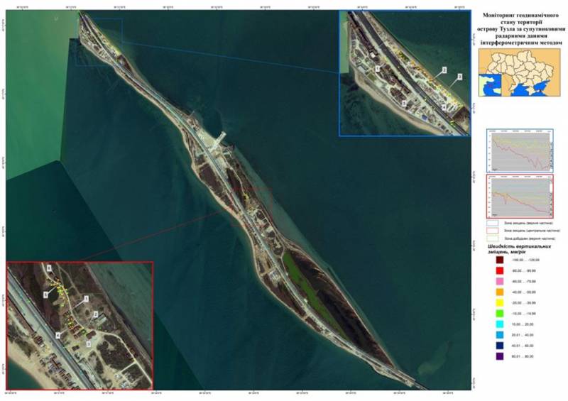
This is followed by "exact numbers of displacement and subsidence": 89 mm per year ("subsidence" of one section), 52 mm ("raising" another section), 10 mm ("subsidence" of Tuzla spit), etc.
Ukrainian specialists “using interferometry” saw the vertical displacement of the arch of the Crimean Bridge, which was additionally reported in the same article.
Only one question arises: if the Ukrainian “interferometry” is as developed as the ability to analyze satellite images, then why haven't the satellite images, for example, from Zaroshchensky, from which the Buku of the Ukrainian Armed Forces hit the Malaysian summer, with the same scrupulousness? "Boeing"? Why is there no such detailed analysis of satellite images of strikes of Ukrainian artillery on the residential buildings of Gorlovka, Donetsk, Yasinovataya and other cities of Donbass? At the moment, Ukrainian officials have not received such a directive ... Another thing is the ridiculous attempts to discredit the bridge that connected Crimea to the mainland of Russia.
Calling the Crimean Bridge "illegally constructed," ministry officials, who, in fact, should have turned their energy towards the territories of Ukraine, which were actually occupied by the United States, on Facebook say: "The bridge has sunk."

From the material:
The Kerch Bridge, illegally built by the Russian Federation, is shifting (the results of a space survey). Such conclusions were made on the basis of the interferometric method of data processing of satellite images taken from the side of the temporarily occupied Crimean peninsula and the island of Tuzla. In particular, there are several critical areas where displacement processes occur.
This is followed by "exact numbers of displacement and subsidence": 89 mm per year ("subsidence" of one section), 52 mm ("raising" another section), 10 mm ("subsidence" of Tuzla spit), etc.
Ukrainian specialists “using interferometry” saw the vertical displacement of the arch of the Crimean Bridge, which was additionally reported in the same article.
Only one question arises: if the Ukrainian “interferometry” is as developed as the ability to analyze satellite images, then why haven't the satellite images, for example, from Zaroshchensky, from which the Buku of the Ukrainian Armed Forces hit the Malaysian summer, with the same scrupulousness? "Boeing"? Why is there no such detailed analysis of satellite images of strikes of Ukrainian artillery on the residential buildings of Gorlovka, Donetsk, Yasinovataya and other cities of Donbass? At the moment, Ukrainian officials have not received such a directive ... Another thing is the ridiculous attempts to discredit the bridge that connected Crimea to the mainland of Russia.
Information