"Admiral Vladimirsky" has measured the depths of the ocean on 44 thousand. Km route

47
The oceanographic vessel Admiral Vladimirsky is currently on the final stretch of the journey, returning to Kronstadt after the Antarctic Expedition, reports TASS the message of the representative of the Ministry of Defense Igor Dygalo.

"Admiral Vladimirsky" has measured the depths of the ocean on 44 thousand. Km route


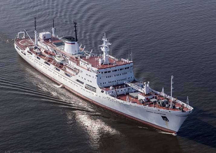
“The crew and military hydrographers on board conducted a number of important studies of the waters of the Antarctic marine areas,” Dygalo said.

“Being at sea from 6 November 2015, Admiral Vladimirsky produced 44 370 linear kilometers of route depth measurements, of which 17 395 linear kilometers in Antarctic waters, and at the Antarctic Progress station 5 880 linear km,” said.

According to the officer, "this is a huge amount of work that will be analyzed in the interests of the work on the proof-reading of navigational charts."

He also said that “the details of all phases of the hydrographic expedition of the Russian Navy to Antarctica, which was the first in more than 30 years, and the results of studies of the Antarctic seas will be presented to the public”.
47 comments
Information
Dear reader, to leave comments on the publication, you must sign in.
  1. +9
    16 March 2016 13: 57
    The country and the fleet are raising their heads and it pleases, but about military hydrographs, I was generally pleased !!! Oh, something we probably found there, and Nato’s analysts are already sweating !!! Viva, comrades !!!!
    1. +11
      16 March 2016 14: 14
      Ours are looking for "New Swabia" in Antarctica, where in 1945 he dumped all the true "Color of the Third Reich". laughing The Fritz did not have long to sit freely in their "air pockets" hidden under the ice. laughing
      Well, if seriously the news is very pleasant after decades, the Navy conducts such hydrographic studies in Antarctica. wink
      1. +1
        16 March 2016 15: 01
        I wanted to write looking for base 211, but you got ahead of me))
  2. +3
    16 March 2016 14: 00
    Antarctic seas research results will be presented to the public

    It must be assumed that not everyone and not everyone.
  3. -5
    16 March 2016 14: 01
    hydrography at the moment, in deep opera!
  4. -18
    16 March 2016 14: 01
    I can’t do it. What is the practical interest in studying Antarctica, especially for the Defense Ministry.
    1. +3
      16 March 2016 14: 08
      Quote: Winnie76
      I can’t do it. What is the practical interest in studying Antarctica, especially for the Defense Ministry.

      And you calculate how many linear kilometers of depth measurements were made by the "Admiral Vladimirsky" off the coast of Antarctica and you will see that this is only half of the entire depth measurement. More than 20 thousand linear kilometers. were measured clearly elsewhere.
      The minus is not mine.
      1. -1
        16 March 2016 14: 15
        Ok, I agree. But still 20 thousand kilometers were measured around Antarctica. Do we have there that from the ships and pl not push through? The meaning of this event? Maybe better somewhere in the Arctic, Baltic, Kamchatka ... but who knows where
        1. +5
          16 March 2016 14: 24
          Well let's say you go to measure what interests the military. Then you go to Antarctica and measure there any more dofig, the results - to the world community. Questions what, where and when you measured except Antarctica, the average person does not arise. Everyone does it.
          1. 0
            16 March 2016 14: 29
            That is, the theme of Antarctica is especially for the UR patriots. Cover operation.
        2. UVB
          +5
          16 March 2016 14: 31
          Quote: Winnie76
          Ok, I agree. But still 20 thousand kilometers were measured around Antarctica. Do we have there that from the ships and pl not push through? The meaning of this event? Maybe better somewhere in the Arctic, Baltic, Kamchatka ... but who knows where

          Purely hypothetically, only one example - "Yuri Dolgoruky" fires a salvo from the waters of the so-called "Southern Ocean". The territory of the adversary from this direction is practically defenseless. And what, all this information is not needed for our planes?
          1. 0
            16 March 2016 14: 53
            Maybe you are right, but to be honest it is somehow doubtful. The range allows you to stagger right from the pier, and you still need to get to Antarctica through all kinds of SOSUSy at the sight of all Poseidons, Orions and much more
            1. +4
              16 March 2016 15: 12
              Quote: Winnie76
              Maybe you are right, but to be honest it is somehow doubtful. The range allows you to stagger right from the pier, and you still need to get to Antarctica through all kinds of SOSUSy at the sight of all Poseidons, Orions and much more

              "Shmalnut" directly from the pier - it is certainly possible, but if only someone else did not "shmalnut" along the piers a little earlier. But no one really knows the areas of combat duty, even "ours", especially if the boat commander is smart. He will never lie exactly there, as it is written in the secret envelope. There are enough traitors in the headquarters.
              1. +3
                16 March 2016 15: 23
                Quote: Алексей_К
                But no one really knows the areas of alert, even "our

                Recently I read about the K-524 pr.671RTM cruise through the Robson and Kenedy Straits, so even "ours" were shocked! bully
        3. +4
          16 March 2016 14: 47
          Quote: Winnie76
          Ok, I agree. But still 20 thousand kilometers were measured around Antarctica. Do we have there that from the ships and pl not push through? The meaning of this event? Maybe better somewhere in the Arctic, Baltic, Kamchatka ... but who knows where

          Alexander, will you give 100% to the fact that Russian nuclear submarines will not appear off the coast of Antarctica? And if they appear, who will tell them the depth and topography of the bottom?
      2. +2
        16 March 2016 15: 36
        Here to the point. And under the military hydrography can fall not only the measurement of depths, but also the search for underwater objects of a potential enemy, for example. What kind of equipment can be installed on a ship - one can only guess. And adjusting the maps is very useful for ships supplying our polar stations on Antarctica.
    2. +1
      16 March 2016 14: 24
      and what kind of intelligence are you working on? Can you show the route of our SSBNs?
      1. 0
        16 March 2016 14: 31
        Through the territory of Antarctica? Of course show wink Missed you without fresh hounds ...
        1. +1
          16 March 2016 14: 48
          What can you do, you have to be bored, Psaka on maternity leave laughing but you do not worry, she will return laughing read here, this is from the old psak: http: //topwar.ru/17325-atomnye-torpednye-i-mnogocelevye-podvodnye-lodki-pro
          ekt-671.html
    3. +4
      16 March 2016 15: 06
      Quote: Winnie76
      I can’t do it. What is the practical interest in studying Antarctica, especially for the Defense Ministry.

      The modern submarine fleet must know where it is possible to "lay down" on alert in safety. And at the same time to protect Antarctica from the impudent capture of the Anglo-Saxons. There the Norwegians, their fjords cannot be protected from the "Russian" submarines, and have already declared part of international Antarctica their property.
    4. +4
      16 March 2016 15: 23
      Quote: Winnie76
      I can’t do it. What is the practical interest in studying Antarctica, especially for the Defense Ministry.

      "Akademik Vladimirsky" worked in Antarctica as part of the 61st Antarctic expedition.
      And here is what this OIC was doing:
      Throughout the passage, hydrographs performed routing surveys from Catepown to the marginal seas of Antarctica. In total, 24197 linear kilometers of measurement were covered for this stage of the campaign. 2 distinctive depths were found (markedly different in a smaller direction from the depths surrounding them). After processing the information, information about them will appear on sea charts.
      Along the entire route, urgent (in standard hydrometeorological terms) hydrological observations were carried out, four soundings per day, accompanied by meteorological observations. At hydrological stations, using probes - profilographs - special instruments lowered into the ocean to a certain depth, vertical profiles of characteristics such as temperature, salinity, dissolved oxygen concentration and sound velocity were obtained. In total, 238 stations were completed, of which 132 in Antarctica.
      In certain areas of interest to research, spatial series of such soundings were performed to obtain hydrological sections. Particularly interesting results are obtained when performing sections on the transition from the shelf of the marginal seas to the ocean bed, through the continental slope. Here, the most important physical and chemical characteristics of water masses can undergo radical changes, literally at a distance of less than a mile. We have to make stations at very short intervals, which requires hard work and skill of skippers and hydrologists.

      Who needs vertical profiles of temperature, density and speed of sound - need to be explained? wink

      And here is why work was carried out in the Antarctic itself:
      From the point of view of oceanography, the Southern Ocean is interesting not only for the inexhaustibility and poorly studied of its spaces, but also for the key, climate-forming processes taking place here. Each winter, the ice of the Southern Ocean doubles the area of ​​the ice continent, and in summer, thawing, it decreases, which certainly affects the climate of the entire planet. Besides, on the Antarctic shelf and the mainland slope, the coldest and densest Antarctic bottom waters are formed and reach abyssal depths (3000 - 6000 m), which have a significant impact on the global structure and meridional circulation of the oceans. These waters, which occupy the lowest layer of the ocean, spread along the bottom to the north up to the temperate latitudes of the northern hemisphere. The variability of the rate of their formation affects the change in the intensity of the meridional circulation and, ultimately, on climate change.

      In short - current values ​​and data for predicting such interesting things as density, speed of sound, thermocline, underwater sound channel ..
      1. +1
        16 March 2016 15: 39
        Alexey, respect and respect wink
    5. +3
      16 March 2016 15: 25
      Plus:
      The main result of the work of the group of radio navigation measurements (chief technician Mikhail Zibrov) was the conclusion about the reliability of the domestic radio navigation system GLONASS, with which, the accuracy of determining the location does not go beyond 6 meters. At the same time, she can cope with her tasks without GPS satellites. Based on the results of processing data on the working areas of the coverage of GLONASS, RSDN-20 and other systems, a correction will be made in the next issue of the directory “Radio-technical means of navigation equipment”».

      Specialists of the Institute of Radio Electronics. Academician V.A. Kotelnikova (Alexei Paveliev) and the Research Institute of Applied Geophysics (Sergey Uskov) were studying the state of the ionosphere (an atmosphere layer from an altitude of 50-60 km to 1000 km saturated with charged particles - ions and free electrons). Their global conclusion is the presence of a low background of ionospheric disturbances in the Antarctic zone. The results of their work will be used by Roshydromet. They will also be useful to military sailors - they managed to identify a certain regular relationship between the operation of the receiver indicators of radio navigation systems and the level of perturbation of the ionosphere.

      http://www.rgo.ru/ru/article/admiral-vladimirskiy-po-doroge-domoy

      In 2014-2015. "Admiral Vladimirsky" sailed along the northern route - along the NSR and across the Pacific Ocean and the Panama Canal back to the Atlantic.
  5. +1
    16 March 2016 14: 02
    Where Russian hydrographs passed, there can only be Russian Earth ...
    1. 0
      16 March 2016 17: 49
      Quote: Evil 55
      Where Russian hydrographs passed, there can only be Russian Earth ...

      ... or Russian water.
    2. 0
      16 March 2016 17: 49
      Quote: Evil 55
      Where Russian hydrographs passed, there can only be Russian Earth ...

      ... or Russian water.
  6. +2
    16 March 2016 14: 02
    Japan loaf ... from November 6 !! yes it’s time for you to erect a monument to sailors !! not ..in infantry better laughing
    1. +3
      16 March 2016 14: 50
      Quote: Yak-3P
      Japan loaf ... from November 6 !! yes it’s time for you to erect a monument to sailors !! not ..in infantry better

      30 years ago "Vladimirsky" did not climb out of the seas for a year and a half bully
  7. -2
    16 March 2016 14: 03
    And besides minuses, will there be any arguments?
    1. 0
      16 March 2016 14: 42
      And besides minuses, will there be any arguments?

      We have not heard your arguments either. Just read your opinion with which far from all (judging by the minuses) agree.
      1. 0
        16 March 2016 14: 51
        I understand that his arguments are wasted time and money (after all, so many kindergartens could be opened on them crying ) shorter than FSO laughing
      2. -4
        16 March 2016 15: 04
        You have captured the essence. wink I have no arguments, I have a question - "What for all this?"
        1. 0
          16 March 2016 15: 09
          "What for all this?"

          What for? Doing science?
          1. -4
            16 March 2016 15: 35
            Science is too general a concept. You can, for example, study the sphero-horse in a vacuum, or is there life on Mars. And the country's resources are actually finite
            1. +1
              16 March 2016 17: 03
              Science is too general a concept. You can, for example, study the sphero-horse in a vacuum, or is there life on Mars. And the country's resources are actually finite

              You got it. Chessword. Your mental capabilities are finite and I can clearly see their blunt end. With your liberal inclinations, you are clearly mistaken in the site. You need to go to Echo's fans, they will tell you what you want to hear (that Putin is not clear on what he wastes money and everything like that). And "Glory to the Navy" and other slogans, we do not forget without you. No navies of any country are obliged to report to the population on the essence of their scientific research. I hope this is clear. Do not just say that it is not democratic. Try to ask such questions in the US (you can find the US Navy website yourself) look for democracy and glasnost there. Maybe believe that she is there.
        2. The comment was deleted.
        3. 0
          16 March 2016 15: 17
          I have one answer for you: laughing
    2. The comment was deleted.
    3. +2
      16 March 2016 15: 17
      Quote: Winnie76
      And besides minuses, will there be any arguments?

      This will give you your home address. The arguments are local, perhaps, instead of minuses, they will appear. You understand that in the "chat" the only arguments are cons and comments. What other arguments do you need?
      1. -2
        16 March 2016 15: 30
        I don’t understand about my home address, are you going to visit me? I have not hid from anyone and am not going to. He asked a logical question, received a bunch of disadvantages instead of serious arguments from smart people. Realized. The question is wrong))))). It was necessary to write something like "Glory to the Navy", or "The Northern Fleet will not let you down." But it's boring to deal with such crap
  8. -1
    16 March 2016 14: 07
    Hitler's submarine was not found by chance? :)
  9. 0
    16 March 2016 14: 08
    I already thought that our still 5 applications for the Arctic at the UN are preparing to expand the shelf)))
    1. +2
      16 March 2016 14: 11
      Quote: AdekvatNICK
      I already thought that our still 5 applications for the Arctic at the UN are preparing to expand the shelf)))

      Then in the Antarctic, perhaps .... hi
    2. +1
      16 March 2016 14: 48
      Quote: AdekvatNICK
      I already thought that our still 5 applications for the Arctic at the UN are preparing to expand the shelf)))

      This is the routine work of military hydrographs.
  10. 0
    16 March 2016 14: 15
    Quote: Winnie76
    I can’t do it. What is the practical interest in studying Antarctica, especially for the Defense Ministry.

    - Who goes for honey with balloons? When you answer this question, then the practical interest in studying the Antarctic MoD of the Russian Federation will probably become clearer to you! laughing
  11. The comment was deleted.
    1. 0
      16 March 2016 14: 27
      Who knows, he won’t say it! If you don’t understand something, this doesn’t mean that everyone will immediately rush to tell you. There is such a thing as Military Secret.
      1. The comment was deleted.
        1. 0
          16 March 2016 15: 37
          Here is the given example in you, and it is rushing. I answered you that they know it, those for whom it was done, without any cheers and pindos. If you are not able to understand this, then I can not help you fool
    2. 0
      16 March 2016 14: 31
      You plus for a sense of humor +++ drinks
  12. 0
    16 March 2016 14: 28
    Quote: Angry
    Where Russian hydrographs passed, there can only be Russian Earth ...

    Similarly, in the Mahabharata this is mentioned, though there instead of hydrographs a white horse was launched, a good custom)
    Well, we must understand that if not us, then quickly any chantrap from Denmark and other Canada will begin to snivel.
  13. 0
    16 March 2016 18: 08
    Something tells me that he didn’t just measure the depth, not for nothing that the Defense Ministry instead of warships, first of all they order hydrographic vessels. So for the army at this stage they are more important than a cruiser. But let the Americans scratch their turnips, why is this necessary.