"The eyes of the army." Day of the military topographer
Every year February 8 in the Russian Federation celebrates the Day of the military topographer. It was installed in February 2003 by order of the Minister of Defense of the Russian Federation No. 395 and celebrated since 2004. The date of the holiday was set in honor of the adoption of the 8 in February by the 1812 of the Year for the military topographical case. In accordance with this decree, a structure was created responsible for providing the Russian army with cartographic and topographic materials. In fact, is it worth saying that story topographic service in Russia is much longer.
At the root of the military topography
The rapid development of topography began under Peter I, who paid great attention to the improvement of military engineering, geodesy and cartography. In 1711, the Quartermaster’s unit was added to the Russian army, which included, among other things, the task of providing the Russian army with cartographic materials. In the quartermaster units, posts were made for individual officers involved in mapping and collecting information about the terrain. These were the first Russian military topographers. The School of Mathematical and Navigational Sciences appeared in Moscow, where future surveyors and topographers were trained. When the General Staff was created in 1763, 40 headquarters officers and chief officers - surveyors and topographers were included in its structure, which marked the beginning of the military topographic service created later.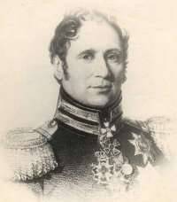 In 1797, his own Imperial Majesty's Depot maps were created, compiling, printing and storing topographic maps and atlases. The director of the Depot Card was subordinate to the quartermaster general of the Russian army. Major General Count Karl Ivanovich Opperman (1766-1831), a professional military engineer who came from a noble family of the Duchy of Hesse-Darmstadt, was appointed Director of the Depot of Cards. After receiving an engineering education, Karl Opperman began military service in the Hessian army, and then asked for Russian citizenship. Empress Catherine II answered in the affirmative and, as it turned out, not in vain. Karl Opperman made a great contribution to the formation of the national military topographic service, engineering troops and, in general, to strengthening the defense capability of the Russian Empire. Under the command of Opperman in the Depot of Cards, an 22 officer service was commissioned, seconded from the Engineering Department, quartermaster and army units. In 1801 — 1804, it was Depo Card that produced and published the Stolistovaya Map of the Russian Empire. February 8 The 1812 of the Depot of Maps was renamed the Military Topographical Depot, and then reassigned directly to the Minister of War. For the period from 1812 to 1863 The military topographical depot became the main body of the Russian army, responsible for the supply of cartographic material.
Body topographers
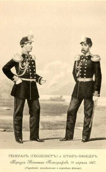
In 1822, under the direction of the Military Topographical Depot, the Topographic Corps was created. His duties included direct topographic and topographic and geodetic support of the Russian army, bringing topographic material to headquarters and troops. The topographer corps included officers - surveyors, cool topographers, cool martial artists, non-class artists, students of topographers and artists, and topographers of non-commissioned officers. Employees of the Corps of Topographers were engaged in conducting topographic surveys, creating maps and plans, surveying the terrain - not only in the interests of the military department, but also the Geological Committee, the Ministry of Agriculture, the Ministry of State Property, the Committee for the Construction of State Roads. In 1832, the Topographer Corps included 70 officers and 456 topographers. 8 mouth was created. The first company, numbering 120 people, was called the company of the Military Topographical Depot. The remaining seven companies operated throughout the Russian Empire. The topographer corps was supervised by the quartermaster general of the General Staff through the Military Topographic Bureau.
Major General Fyodor Shubert (1789-1865) stood at the origins of the organization of the Corps of Topographers. In 1803, at the age of fourteen, Schubert began serving as a column leader in the retinue of His Imperial Majesty in the quartermaster’s unit, then participated in a number of military campaigns in the early 19th century. During World War 1812, Captain Schubert in the position of quartermaster of 2 Cavalry Corps not only engaged in his direct duties, but also showed courage and courage directly during the battles.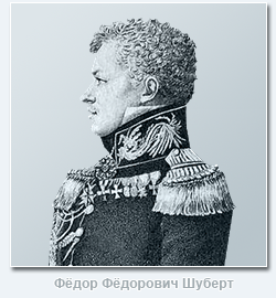 Adjutant General Baron Fyodor Karlovich Korf noted in a report that Schubert personally helped him, under enemy fire, to keep cavalry regiments from retreating. Schubert's bravery contributed to his rapid advancement in the ranks - he was soon given the rank of lieutenant colonel, and then colonel. He served as chief quartermaster in the infantry and grenadier corps. In 1819 was Colonel Schubert was transferred to the General Staff - to the position of chief of the 3 division of the Military Topographical Depot, and the following year became the chief of triangulation and topographical survey of the Petersburg province. Then, in 1820, 31-year-old Colonel Schubert was promoted to major general. Since it was Schubert who developed the project for creating the Corps of Surveyors, it was in 1822 in and appointed to the post of director of the Corps. Three years later he became manager, and in 1832 - Director of the Military Topographical Depot. At the same time, General Schubert also performed the duties of Quartermaster General of the General Staff of the Russian Army. In 1866, the Corps of Surveyors was transformed into the Corps of Military Topographers, which was headed by the Chief of the Military Topographical Department of the General Staff. It is noteworthy that the practice of combining the posts of the head of the topographic service and the head of the Military Topographical Directorate of the General Staff is still preserved in the Russian armed forces. It was 1866 the strength of the Corps of Military Topographers was 643 man. It served as 6 generals, 33 headquarters officer, 156 chief officers, 170 topographers, 236 topographers noncommissioners, 42 topographer's apprentice. It should be noted that in 1866 as part of the General Staff, the Military Topographic Department was created, replacing the Military Topographical Depot as the central governing body of the military topographic service. As for the military topographical depot, it was eliminated. Also, military topographic departments were created in the headquarters of military districts - Orenburg, West Siberian, East Siberian and Turkestan. For the rest of the military districts, it was envisaged to have a seconded officer and topographers from the military topographers 2-4. In 1877, in accordance with the new provision on the Corps of Military Topographers, the number of personnel of this service was reduced to 515 people. At the same time, 6 general posts, 26 posts of staff officers, 367 chief officers and topographers also remained in the corps. It should be noted that civilian officials who were in the staff of the Corps of Military Topographers and who had the corresponding civil ranks according to the Table of the ranks of the Russian Empire were called classy topographers. Also in 1890 It also adopted the Regulations on the Field Administration of the Troops in Peacetime, which provided for a staff of topographer officers in various formations. So, 5 staff officers of the military topographers were seconded to the army headquarters, and an chief officer and 2 junior topographers were assigned to 1 headquarters corps. In 1913 was The feast of military topographers was established - February 10 (in honor of Rev. Efrem Sirin). With the improvement of technical equipment in the arsenal of the Russian army, the modernization of the methods of topographic activity also took place. So, after the telegraph network was distributed in the Russian Empire, the method of determining geographical longitudes based on the transmission time by telegraph between designated points, developed by Colonel Forsch, was used. aviation, officers of the Military Surveyors Corps began to actively use the aerial survey method. At the beginning of 1917, photometric (later photogrammetric) parts were created.
How military topographers were taught in the Russian Empire
 It should be told about the training of topographical officers in the Russian Empire. Topographical service, in contrast to the service in the guards, cavalry units, in the naval navy, never enjoyed special prestige, associated with the need for long and painstaking study, complex, routine work. Therefore, among topographical officers there were few immigrants from noble families. For a long time, future topographers learned their job and only after 8-12 years of work and passing exams did they receive an officer rank. The first educational institution to train specialists in topography and geodesy was the School of Mathematical and Navigational Sciences, opened by Peter I. In 1822, after the creation of the Topographers Corps, the School of Topographers was opened. In the “Supplement to the Regulation on the Corps of Topographers” the basic principles of organizing the training of topographic officers were listed and the establishment of the School of Topographers was announced. On October 22, 1822 the school was opened - as a two-year school with a four-year term of study. Since that time, October 22 is considered the traditional annual holiday of an educational institution preparing military topographers of the Russian army. The first graduation of the School of Topographers was held in 1825. Only 12 officers who received the rank of ensign were released. In 1827, the second graduation of officers took place, after which each year the Russian army began to replenish with new officers - topographers. The small staff of the Corps of Military Surveyors determined a small number of graduates of the School of Surveyors. But, as they say, graduates of the school took "not quantity, but quality."
In 1832, the School of Topographers was renamed the School of Topographers, which was associated with the absence of those benefits that were assigned to specialized schools. When all the topographers of the Topographic Corps were consolidated into companies, the company stationed in St. Petersburg formed the School of Topographers, whose staff included 120 topographers of 1 and 2 classes. In 1863, the School of Topographers returned the former name - the School of Topographers; at the same time, graduates of the School of Topographers were given the right to enter the geodetic department of the Academy of the General Staff. 24 December 1866 (5 January 1867) was approved by the new name of the School of Topographers - Military Topographic Junker School. The school curriculum has been expanded. However, in 1883-1885's. enrollment at the school was not conducted due to the growth of the revolutionary movement in the country. After 1886 resumed recruiting in September, it was again deprived of the privileges of other cadet schools and existed in that status until 1892, when it was again granted the right for graduates to enter the geodetic department of the Academy of the General Staff. In 1906, an additional geodetic class was introduced into the school, the number of which was determined in 10 people. In total, over the 95 years of the school’s existence, from 1822 to 1917, it trained more than 1,5 thousands of specialists in the field of military topography and geodesy with an officer’s rank. The topographers played a crucial role in ensuring the defense capacity of the Russian empire, and took part in all possible military campaigns. Moreover, the level of professional training and education allowed the leaders of the Corps of Military Topographers to take over the leadership of the General Staff if necessary. Among the officers of the military-topographic service of the Russian Empire were prominent scientists who made a great contribution to the development of topography as a science. November 15 (November 28 - new style) 1917 of the year issued an order to demobilize the Russian army. However, the Corps of Military Topographers continued under the new name until 1923 as the structure of the Military Topographical Directorate as part of the All-Russian General Staff (Vseroglavshtaba), created by 8 in May 1918 and existed before 10 in February 1921, when it was combined with Field Headquarters of the Red Army in the Headquarters of the Red Army.
From the military topographic school to the school
In 1923, the Red Army Corps of Military Topographers Corps was renamed the Red Army Military Topographic Service. Thus began the story of a qualitatively new structure. At the Headquarters of the Red Army, the Military Topographical Department was created, after the creation of the General Staff of the Red Army in 1935, which in turn became part of it as a department. In the Soviet Army, the military topographic service was further developed and, in fact, formed in the form in which it still exists. Being a part of the headquarters service, the military topographic service had its own organs at the headquarters of formations, operational units, and also had its own special units and institutions, which included topographic, geodesic, aerophoto topographic detachments, map warehouses, cartographic factories. The main task of the military topographic service remained the compilation and preparation of topographic maps, the collection of geodetic data, the organization of topographic training of troops, research work in the field of cartography, geodesy, aerial survey.
After the beginning of reforms in the military sphere, caused by the October Revolution and the construction of the Red Army, there was a need to create a special educational institution for the training of military topographers. The fact is that in accordance with the Order of the Council of People's Commissars for Naval Affairs No. 11 of 14 in November 1917, the military schools of the old Russian army were supposed to be disbanded. At the same time, the order of the Chief Commissariat of All Military Schools of the Russian Republic No. 113 of November 18 and No. 114 of November 28 of 1917 specified that special technical and naval military schools, the Military Topographic School and the Main Gymnastic School fencing school is not subject to disbandment. This moment was very important, because it demonstrated a focus on preserving the experience that was accumulated by these military schools. However, 2 in January 1918, the Executive Committee of the Council of Khvalynsk, which was identified as a gathering place for the leave of the junkers of the military topographical school, decided to dissolve the school. But this dissolution was only a formal moment in the history of this military school. 18 July 1918, in accordance with the order of the People's Commissar for Military Affairs, the first Soviet military topographic courses were opened in the city of Volsk on the basis of the former Military Topographical School. However, since Khvalynsk was in the hands of white Czechs, who decided to transfer the personnel of the junkers of the military topographical school in Novonikolayevsk and then to Omsk, it was decided to open the Soviet military topographical courses not in Volsk, but in Petrograd. The former teacher of geodesy GG was appointed the head of the Petrograd courses. Strakhov, military commissar - E.V. Rozhkov. Already 16 December 1918, the courses began classes. This day is considered the founding day of the Soviet school of military topographers. 50 people were enrolled to attend the course, and 11 people continued to study in the senior year. By 1 April, 1919 students were trained in courses 131. The Soviet authorities succeeded in recruiting a number of prominent scientists and teachers, which ensured a normal learning process on the courses and the transfer of knowledge and experience to a new generation of cadets. In 1919, a three-year course was established, and 5 in June 1919. 10 cadets who completed the senior course were distributed as topographers to the Workers 'and Peasants' Red Army. These were the first military topographers, already prepared by the Soviet authorities.
Meanwhile, the staff of the school cadets transferred to Novonikolayevsk continued their studies. Autumn 1919 there were even accepted new cadets. When Novonikolaevsk liberated parts of the 5 Army of the Eastern Front of the Red Army, it was decided to continue the training process of the cadets. To guide the political life was appointed military commissar F. Parfenov. 7 February 1920 city The school was renamed to Siberian Military Topographic Courses. Soon they were transferred to the liberated Omsk, where they were located in the building of the Omsk Cadet Corps. In 1921 was on the basis of the courses the Omsk military topographic school was opened. On November 1 1921 147 cadets were trained there. November 9 1922 city The Omsk military topographic school was officially called the 2 of the Omsk military topographic school, and at the beginning of 1923, it was relocated to Petrograd. In Petrograd, both military topographic schools were merged, after which the country's only military topographic institution, the Petrograd military topographic school, was revived again. In 1924 was At the First Congress of military topographers, it was decided to increase the level of training in the military topographic school. This decision was facilitated by the speech of the head and commissioner of the Military Topographical Department of the Red Army Headquarters A. AND. Artanov, who drew attention to the highly specialized nature of training in school. Therefore, in 1925 it was decided to improve the school’s curriculum, raise the level of political work in the school, and create with it the Commander Training Courses (KUKS). In addition, commanders from various branches of the armed forces were sent to the school, who decided to receive a military topographic education. В 1928-1929 гг. school attached aerosveno. Positive changes in the organization of the educational process of the school could not be noted by the higher management. In 1929 was Chief of the Military Topographical Department of the Headquarters of the Red Army A. AND. Artanov praised the school for good equipment of classrooms, especially noting the photo lab classes, transformer and assembly classes, military classes and terrain. Simultaneously with the improvement of the training base, the number of cadets also increased, since the Red Army needed an increasing number of military specialists, topographers, who were sent to serve in army units for further service. The training of photogrammetrists, advanced training of specialists - topographers, geodesists, cartographers, as well as retraining of top-general commanders, gunners, and military engineers on topographic specialties began at the Advanced Training Courses for the commanding staff. The cadets of the school were trained in parts of the Red Army as junior commanders. In 1937 was The military topographic school was transformed into the Leningrad Military Topographical School. Graduates of the school received the military rank of lieutenant. Since the second half of 1930-ies. The lieutenants issued by the school took part in a number of military conflicts, primarily in battles at Lake Hassan and on the Khalkhin Gol river.
Military topographers during the war
 The path of teachers and graduates of the Leningrad Military Topographic School in the Great Patriotic War is full of exploits and is covered with military glory. After the departure of Lieutenant-Colonel A. Gusev, the head of the secondary vocational school, the college was headed by Colonel K. Kharin, who previously headed the training department. 30 June 1941. School cadets began preparing for the defense of the Strugo-Krasnensky camp, but then were returned to Leningrad. Sophomores who passed the control tests, in July 1941, were prematurely promoted to lieutenant and sent to the front. In connection with the war, the school moved to an accelerated one-year period of study. During the war years, the main task of the school was the accelerated training of specialists for the artillery topographic service, carried out in the 4-m special training detachment. In July, 1942, Col. K.N. Kharin, who headed the school, went to the front, and Lieutenant Colonel P.S. became the new head of the school. Pasha, who, in turn, came from the ranks of the army. At the time described, the school was stationed in Ababkovo, and only in January of 1945 was it decided to return to Leningrad. 5 April 1945 school was awarded the Red Banner and given the name "Leningrad Red Banner Military Topographical School". During the Great Patriotic War, more than 3 000 graduates of the Leningrad Military Topographic School were awarded orders and medals.
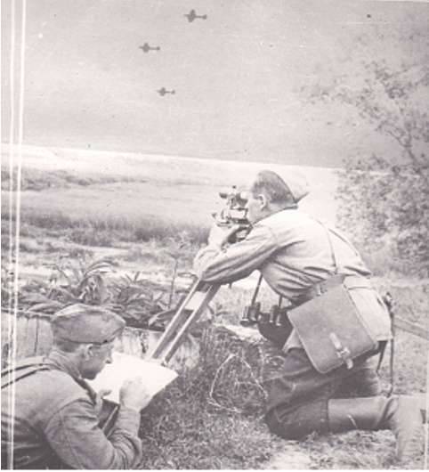
The Great Patriotic War practically in its first months revealed the main shortcomings of the pre-war organization of the military topographic service in the Red Army. Firstly, it turned out that the required number of maps was missing from the troops; in some units there were simply no such cards. The reason for this was the location of the card stores on the western border of the Soviet Union. The retreating Soviet troops were forced to destroy card depots in the Baltic, Western, and Kiev military districts, so that the most sensitive information could not be obtained by the advancing enemy. In the territories occupied by Hitler Germany, a number of the most important objects of the military topographic service turned out to be - a cartographic factory in Kiev, an optical-mechanical profile workshop in Lviv, cartographic units in Riga and Minsk. Secondly, given that before the war, the bulk of the military-topographic parts of the Red Army stationed in the west of the Soviet Union, from the very first days of the war their personnel went to the front. The loss of the military topographic service in 1941 amounted to 148 officers, 1127 sergeants and soldiers, 15 civil servants. Considering that military topographers are narrow specialists, whose preparation requires not only special education, but also obtaining the necessary experience, it can be said that in the first months of the war these losses were irreparable. Therefore, we had to transfer the military topographic school to the shortest possible training periods, as the shortage of military topographers was particularly acute in this situation. The military topographic service in the most difficult conditions of the Great Patriotic War had to solve a very extensive range of tasks, which included: creating and updating topographic maps, publishing topographic maps for operating and logistical units in huge quantities, delivering, storing and issuing maps, photographing the terrain, including including directly in the course of hostilities, control of the accuracy of binding elements of the artillery combat orders; notching landmarks on the ground; tactical interpretation of aerial photographs and determination of the coordinates of enemy targets; topographic survey area. The military topographic service did not forget about such an important task as the organization of general topographic training of troops, which was also administered by military topographers. At the same time, no matter how difficult it was for military topographers on the fronts, the tasks for further study of strategically important locations in other regions of the Soviet Union, including far from the front line, in the Far East and Central Asia, in Siberia were not canceled. in the Urals.
The combat path of the Soviet military topographers
The colossal experience gained by military topographers in the years of the Great Patriotic War was used in the post-war years. It was the post-war period that became the epoch of the highest development and strengthening of the Military Topographic Service of the Soviet Army. The overall complication of military affairs in the second half of the twentieth century. demanded from the Military Survey Service of the SA to solve a number of new important tasks. These included: the creation of the world space geodetic network and the justification of the geocentric coordinate system for the use of rocket weapons; creation of large-scale digital maps for high-precision weapons guidance systems; the creation of means of observing space vehicles and new topographic and geodetic equipment; improvement of mobile topographic and geodetic support equipment for solving urgent tasks at the operational-tactical level; creation of electronic topographic maps for automated troop control systems, etc. Accordingly, the solution of these tasks required a general professional development of military topographers, and an improvement in their training. In the post-war period, the educational process was also improved in the Leningrad Military Topographic School. So, with the emergence and improvement of nuclear missile weapons, compulsory studies of nuclear weapons and protection against nuclear weapons were introduced into the officers training program and curricula. In addition, military topographers are beginning to gain more extensive knowledge of a variety of disciplines that are extremely important for any officer. School cadets begin to study military engineering training, rocket weapons and artillery, automotive, electronics. Do not forget the school and give cadets knowledge of military pedagogy and psychology - in fact, many of them will not only work in the field of topography, but also lead the staff. In 1963, the school received a new name - the Leningrad Military Topographical Red Banner School. The further development of the armed forces required the transfer of most of the country's military schools from among the secondary military schools to higher military schools. In 1968, the Leningrad Military Topographic School was renamed the Leningrad Higher Military Topographic Command Red Banner Red Order of the Red Star School. Accordingly, a four-year study period was established, the transition to the system of departments was carried out. The school created 11 departments: phototophotography, photogrammetry, geodesy and astronomy, higher geodesy, radio geodesy and radio electronics, cartography, tactical disciplines, higher mathematics, physics and chemistry, Marxism-Leninism, foreign languages, as well as the Russian language, automotive training, physical training. As in other higher military schools, in the Leningrad Higher Military Topographic Command School a battalion appeared to support the training process. As the school became higher, the regular category “Major General, Lieutenant General” was established for its superiors, and for the Deputy Heads of the school - one level lower. The full-time Colonel category corresponded to the heads of departments, their deputies and senior teachers, and the Lt. Col. The 1980 School was named after General of the Army A.I. Antonov.
A serious test for Soviet military topography in the 1980s was the war in Afghanistan. The fighting on the territory of another state, especially with such a complex and diverse terrain, was a real exam for the military topographic service. Boris Pavlov, who led the topographic service of the 40 Army, recalled in an interview published in the Military-Industrial Courier for 2009 a year, he recalled that at the initial stage of the hostilities in Afghanistan, the Soviet command did not possess large-scale maps of the entire territory of this state (See: Umantsev, V. By exact reference points. Afghan spirits searched for any opportunity to get Soviet maps // Military Industrial Courier, 2009, No. 8 (274)). The largest map was the 1 scale map: 200 000. Accordingly, military topographers were faced with the task of creating such maps of a larger scale - first 1: 100 000, and then 1: 50 000. As the officer recalled, “1: 100 000 scale maps of the 40 Army were secured by 1985 on 70-75 percent, by 1986-th - on almost all 100. And the 1: 50 000 scale maps were provided completely somewhere around the 1986-1987 years. ” Boris Pavlov, in the same interview, estimated the topographic training of Soviet officers as weak, noting that his subordinates from the army’s topographic service had to conduct numerous topographic training sessions for officers of all units, and even lieutenants-topographers in this case acted as teachers before their senior officers. In general, the topographic service in Afghanistan coped with its tasks adequately and by the second half of the 1980s. was able to provide large-scale topographic maps of all units operating in the territory of this state.
Topographers remain "the eyes of the army"
In 1991, in connection with the reforms carried out in the country and the cessation of the existence of the Soviet Union, the Leningrad Higher Military Topographic Command Red Banner Red Star School was renamed the St. Petersburg Higher Military Topographical Command School. In 1993, a five-year study period was introduced at the school, two faculties were created — topographic and geodesic. Then, in the era of renaming military schools into institutes, the school received a new name - the Military Topographic Institute named after A.I. Antonov (Military Institute (topographical)). In 2006, the institute was incorporated as a branch of the famous Military Space Academy. Mozhaisky. Since 2011, the former military topographic institute is part of the academy as a faculty of topographic and geodetic software and cartography (the so-called “7 Faculty”), with departments of topographic and geodetic software, cartography, high geodesy, photo topography and photogrammetry, metrological equipment for weapons, military and special equipment. The faculty continues training officers - specialists in the field of military topography and geodesy.
Meanwhile, it should be noted that complex 1990-s were marked by numerous problems for military topographers. The reduction of funding for the armed forces, low salaries, lack of attention of the state to the elementary needs of military specialists — military topographers also had to go through all this. Many of them were forced, due to circumstances, to leave "as a citizen," and, it must be said, having a good practical education and extensive experience, as well as "bright minds", were perfectly settled in civilian companies. After all, the need for highly qualified specialists in the field of topographic geodesy is also felt in the most important sectors of the Russian economy. At the same time, many “Soviet-hardened” officers remained in military service and made an enormous contribution to the development of military topography already in post-Soviet Russia.
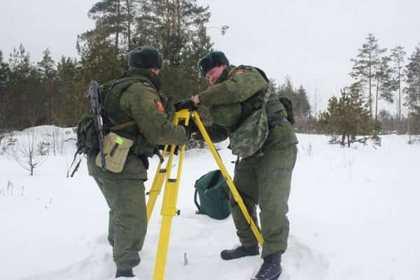
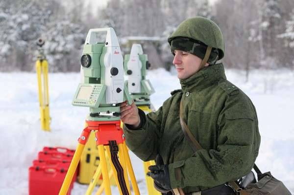
In modern conditions, the old paper cards have long been replaced by electronic, much more convenient to use. Military topographers are equipped with the latest mobile geodesic complexes, recording the smallest changes in the terrain while traveling along a route. To transfer the coordinates to the troops, these complexes can be at a distance of 50 km. At the same time, the army does not refuse paper cards either - after all, it is technics, and in the event of its refusal or interruption, the old, tested grandfather's card can come to the rescue. An experimental Center for Geospatial Information and Navigation of the Southern Military District has been created in the Southern Military District. With the help of the latest developments in the field of digital and IT-technologies, the military topographers of the 21st century monitor the state of the radionavigation field of satellite navigation systems GLONASS and GPS, provide the automated control systems of the military district and high-precision weapons complexes with geospatial information. Within 10 minutes, military personnel can deploy the latest hardware and proceed with combat missions. As noted on the website of the Ministry of Defense of the Russian Federation, the “Violit” and “ARM-EK” software and hardware complexes and the Volynets mobile digital topographic system are in service with the experimental Center. The technical equipment of the Center makes it possible to carry out tasks assigned to military topographers both directly at the place of permanent deployment and in field conditions, if necessary moving forward to the terrain.
In connection with the cessation of the existence of the USSR, the Military Topographical Service of the Armed Forces of Russia was formed in 1991 in the following 1992 was transformed into the Topographical Service of the Armed Forces of the Russian Federation. The Chief of the Topographic Service of the Armed Forces of the Russian Federation is simultaneously the Chief of the Military Topographical Directorate of the General Staff of the Armed Forces of the Russian Federation. Currently, this position is occupied by Colonel Zaliznyuk Alexander Nikolaevich, first from 2013 to 2015. who held the post of chief engineer of the Military Topographical Directorate of the General Staff of the Armed Forces of the Russian Federation. Russian military topographers continue to solve a number of complex tasks in the interests of strengthening the defense capacity of the Russian state. It remains to wish the people of this difficult and necessary military profession not to lose and constantly improve their skills, do without losses, and most importantly, always remain necessary to their country.
At the root of the military topography
The rapid development of topography began under Peter I, who paid great attention to the improvement of military engineering, geodesy and cartography. In 1711, the Quartermaster’s unit was added to the Russian army, which included, among other things, the task of providing the Russian army with cartographic materials. In the quartermaster units, posts were made for individual officers involved in mapping and collecting information about the terrain. These were the first Russian military topographers. The School of Mathematical and Navigational Sciences appeared in Moscow, where future surveyors and topographers were trained. When the General Staff was created in 1763, 40 headquarters officers and chief officers - surveyors and topographers were included in its structure, which marked the beginning of the military topographic service created later.
In 1797, his own Imperial Majesty's Depot maps were created, compiling, printing and storing topographic maps and atlases. The director of the Depot Card was subordinate to the quartermaster general of the Russian army. Major General Count Karl Ivanovich Opperman (1766-1831), a professional military engineer who came from a noble family of the Duchy of Hesse-Darmstadt, was appointed Director of the Depot of Cards. After receiving an engineering education, Karl Opperman began military service in the Hessian army, and then asked for Russian citizenship. Empress Catherine II answered in the affirmative and, as it turned out, not in vain. Karl Opperman made a great contribution to the formation of the national military topographic service, engineering troops and, in general, to strengthening the defense capability of the Russian Empire. Under the command of Opperman in the Depot of Cards, an 22 officer service was commissioned, seconded from the Engineering Department, quartermaster and army units. In 1801 — 1804, it was Depo Card that produced and published the Stolistovaya Map of the Russian Empire. February 8 The 1812 of the Depot of Maps was renamed the Military Topographical Depot, and then reassigned directly to the Minister of War. For the period from 1812 to 1863 The military topographical depot became the main body of the Russian army, responsible for the supply of cartographic material. Body topographers
In 1822, under the direction of the Military Topographical Depot, the Topographic Corps was created. His duties included direct topographic and topographic and geodetic support of the Russian army, bringing topographic material to headquarters and troops. The topographer corps included officers - surveyors, cool topographers, cool martial artists, non-class artists, students of topographers and artists, and topographers of non-commissioned officers. Employees of the Corps of Topographers were engaged in conducting topographic surveys, creating maps and plans, surveying the terrain - not only in the interests of the military department, but also the Geological Committee, the Ministry of Agriculture, the Ministry of State Property, the Committee for the Construction of State Roads. In 1832, the Topographer Corps included 70 officers and 456 topographers. 8 mouth was created. The first company, numbering 120 people, was called the company of the Military Topographical Depot. The remaining seven companies operated throughout the Russian Empire. The topographer corps was supervised by the quartermaster general of the General Staff through the Military Topographic Bureau.
Major General Fyodor Shubert (1789-1865) stood at the origins of the organization of the Corps of Topographers. In 1803, at the age of fourteen, Schubert began serving as a column leader in the retinue of His Imperial Majesty in the quartermaster’s unit, then participated in a number of military campaigns in the early 19th century. During World War 1812, Captain Schubert in the position of quartermaster of 2 Cavalry Corps not only engaged in his direct duties, but also showed courage and courage directly during the battles.
Adjutant General Baron Fyodor Karlovich Korf noted in a report that Schubert personally helped him, under enemy fire, to keep cavalry regiments from retreating. Schubert's bravery contributed to his rapid advancement in the ranks - he was soon given the rank of lieutenant colonel, and then colonel. He served as chief quartermaster in the infantry and grenadier corps. In 1819 was Colonel Schubert was transferred to the General Staff - to the position of chief of the 3 division of the Military Topographical Depot, and the following year became the chief of triangulation and topographical survey of the Petersburg province. Then, in 1820, 31-year-old Colonel Schubert was promoted to major general. Since it was Schubert who developed the project for creating the Corps of Surveyors, it was in 1822 in and appointed to the post of director of the Corps. Three years later he became manager, and in 1832 - Director of the Military Topographical Depot. At the same time, General Schubert also performed the duties of Quartermaster General of the General Staff of the Russian Army. In 1866, the Corps of Surveyors was transformed into the Corps of Military Topographers, which was headed by the Chief of the Military Topographical Department of the General Staff. It is noteworthy that the practice of combining the posts of the head of the topographic service and the head of the Military Topographical Directorate of the General Staff is still preserved in the Russian armed forces. It was 1866 the strength of the Corps of Military Topographers was 643 man. It served as 6 generals, 33 headquarters officer, 156 chief officers, 170 topographers, 236 topographers noncommissioners, 42 topographer's apprentice. It should be noted that in 1866 as part of the General Staff, the Military Topographic Department was created, replacing the Military Topographical Depot as the central governing body of the military topographic service. As for the military topographical depot, it was eliminated. Also, military topographic departments were created in the headquarters of military districts - Orenburg, West Siberian, East Siberian and Turkestan. For the rest of the military districts, it was envisaged to have a seconded officer and topographers from the military topographers 2-4. In 1877, in accordance with the new provision on the Corps of Military Topographers, the number of personnel of this service was reduced to 515 people. At the same time, 6 general posts, 26 posts of staff officers, 367 chief officers and topographers also remained in the corps. It should be noted that civilian officials who were in the staff of the Corps of Military Topographers and who had the corresponding civil ranks according to the Table of the ranks of the Russian Empire were called classy topographers. Also in 1890 It also adopted the Regulations on the Field Administration of the Troops in Peacetime, which provided for a staff of topographer officers in various formations. So, 5 staff officers of the military topographers were seconded to the army headquarters, and an chief officer and 2 junior topographers were assigned to 1 headquarters corps. In 1913 was The feast of military topographers was established - February 10 (in honor of Rev. Efrem Sirin). With the improvement of technical equipment in the arsenal of the Russian army, the modernization of the methods of topographic activity also took place. So, after the telegraph network was distributed in the Russian Empire, the method of determining geographical longitudes based on the transmission time by telegraph between designated points, developed by Colonel Forsch, was used. aviation, officers of the Military Surveyors Corps began to actively use the aerial survey method. At the beginning of 1917, photometric (later photogrammetric) parts were created. How military topographers were taught in the Russian Empire
It should be told about the training of topographical officers in the Russian Empire. Topographical service, in contrast to the service in the guards, cavalry units, in the naval navy, never enjoyed special prestige, associated with the need for long and painstaking study, complex, routine work. Therefore, among topographical officers there were few immigrants from noble families. For a long time, future topographers learned their job and only after 8-12 years of work and passing exams did they receive an officer rank. The first educational institution to train specialists in topography and geodesy was the School of Mathematical and Navigational Sciences, opened by Peter I. In 1822, after the creation of the Topographers Corps, the School of Topographers was opened. In the “Supplement to the Regulation on the Corps of Topographers” the basic principles of organizing the training of topographic officers were listed and the establishment of the School of Topographers was announced. On October 22, 1822 the school was opened - as a two-year school with a four-year term of study. Since that time, October 22 is considered the traditional annual holiday of an educational institution preparing military topographers of the Russian army. The first graduation of the School of Topographers was held in 1825. Only 12 officers who received the rank of ensign were released. In 1827, the second graduation of officers took place, after which each year the Russian army began to replenish with new officers - topographers. The small staff of the Corps of Military Surveyors determined a small number of graduates of the School of Surveyors. But, as they say, graduates of the school took "not quantity, but quality." In 1832, the School of Topographers was renamed the School of Topographers, which was associated with the absence of those benefits that were assigned to specialized schools. When all the topographers of the Topographic Corps were consolidated into companies, the company stationed in St. Petersburg formed the School of Topographers, whose staff included 120 topographers of 1 and 2 classes. In 1863, the School of Topographers returned the former name - the School of Topographers; at the same time, graduates of the School of Topographers were given the right to enter the geodetic department of the Academy of the General Staff. 24 December 1866 (5 January 1867) was approved by the new name of the School of Topographers - Military Topographic Junker School. The school curriculum has been expanded. However, in 1883-1885's. enrollment at the school was not conducted due to the growth of the revolutionary movement in the country. After 1886 resumed recruiting in September, it was again deprived of the privileges of other cadet schools and existed in that status until 1892, when it was again granted the right for graduates to enter the geodetic department of the Academy of the General Staff. In 1906, an additional geodetic class was introduced into the school, the number of which was determined in 10 people. In total, over the 95 years of the school’s existence, from 1822 to 1917, it trained more than 1,5 thousands of specialists in the field of military topography and geodesy with an officer’s rank. The topographers played a crucial role in ensuring the defense capacity of the Russian empire, and took part in all possible military campaigns. Moreover, the level of professional training and education allowed the leaders of the Corps of Military Topographers to take over the leadership of the General Staff if necessary. Among the officers of the military-topographic service of the Russian Empire were prominent scientists who made a great contribution to the development of topography as a science. November 15 (November 28 - new style) 1917 of the year issued an order to demobilize the Russian army. However, the Corps of Military Topographers continued under the new name until 1923 as the structure of the Military Topographical Directorate as part of the All-Russian General Staff (Vseroglavshtaba), created by 8 in May 1918 and existed before 10 in February 1921, when it was combined with Field Headquarters of the Red Army in the Headquarters of the Red Army.
From the military topographic school to the school
In 1923, the Red Army Corps of Military Topographers Corps was renamed the Red Army Military Topographic Service. Thus began the story of a qualitatively new structure. At the Headquarters of the Red Army, the Military Topographical Department was created, after the creation of the General Staff of the Red Army in 1935, which in turn became part of it as a department. In the Soviet Army, the military topographic service was further developed and, in fact, formed in the form in which it still exists. Being a part of the headquarters service, the military topographic service had its own organs at the headquarters of formations, operational units, and also had its own special units and institutions, which included topographic, geodesic, aerophoto topographic detachments, map warehouses, cartographic factories. The main task of the military topographic service remained the compilation and preparation of topographic maps, the collection of geodetic data, the organization of topographic training of troops, research work in the field of cartography, geodesy, aerial survey.
After the beginning of reforms in the military sphere, caused by the October Revolution and the construction of the Red Army, there was a need to create a special educational institution for the training of military topographers. The fact is that in accordance with the Order of the Council of People's Commissars for Naval Affairs No. 11 of 14 in November 1917, the military schools of the old Russian army were supposed to be disbanded. At the same time, the order of the Chief Commissariat of All Military Schools of the Russian Republic No. 113 of November 18 and No. 114 of November 28 of 1917 specified that special technical and naval military schools, the Military Topographic School and the Main Gymnastic School fencing school is not subject to disbandment. This moment was very important, because it demonstrated a focus on preserving the experience that was accumulated by these military schools. However, 2 in January 1918, the Executive Committee of the Council of Khvalynsk, which was identified as a gathering place for the leave of the junkers of the military topographical school, decided to dissolve the school. But this dissolution was only a formal moment in the history of this military school. 18 July 1918, in accordance with the order of the People's Commissar for Military Affairs, the first Soviet military topographic courses were opened in the city of Volsk on the basis of the former Military Topographical School. However, since Khvalynsk was in the hands of white Czechs, who decided to transfer the personnel of the junkers of the military topographical school in Novonikolayevsk and then to Omsk, it was decided to open the Soviet military topographical courses not in Volsk, but in Petrograd. The former teacher of geodesy GG was appointed the head of the Petrograd courses. Strakhov, military commissar - E.V. Rozhkov. Already 16 December 1918, the courses began classes. This day is considered the founding day of the Soviet school of military topographers. 50 people were enrolled to attend the course, and 11 people continued to study in the senior year. By 1 April, 1919 students were trained in courses 131. The Soviet authorities succeeded in recruiting a number of prominent scientists and teachers, which ensured a normal learning process on the courses and the transfer of knowledge and experience to a new generation of cadets. In 1919, a three-year course was established, and 5 in June 1919. 10 cadets who completed the senior course were distributed as topographers to the Workers 'and Peasants' Red Army. These were the first military topographers, already prepared by the Soviet authorities.
Meanwhile, the staff of the school cadets transferred to Novonikolayevsk continued their studies. Autumn 1919 there were even accepted new cadets. When Novonikolaevsk liberated parts of the 5 Army of the Eastern Front of the Red Army, it was decided to continue the training process of the cadets. To guide the political life was appointed military commissar F. Parfenov. 7 February 1920 city The school was renamed to Siberian Military Topographic Courses. Soon they were transferred to the liberated Omsk, where they were located in the building of the Omsk Cadet Corps. In 1921 was on the basis of the courses the Omsk military topographic school was opened. On November 1 1921 147 cadets were trained there. November 9 1922 city The Omsk military topographic school was officially called the 2 of the Omsk military topographic school, and at the beginning of 1923, it was relocated to Petrograd. In Petrograd, both military topographic schools were merged, after which the country's only military topographic institution, the Petrograd military topographic school, was revived again. In 1924 was At the First Congress of military topographers, it was decided to increase the level of training in the military topographic school. This decision was facilitated by the speech of the head and commissioner of the Military Topographical Department of the Red Army Headquarters A. AND. Artanov, who drew attention to the highly specialized nature of training in school. Therefore, in 1925 it was decided to improve the school’s curriculum, raise the level of political work in the school, and create with it the Commander Training Courses (KUKS). In addition, commanders from various branches of the armed forces were sent to the school, who decided to receive a military topographic education. В 1928-1929 гг. school attached aerosveno. Positive changes in the organization of the educational process of the school could not be noted by the higher management. In 1929 was Chief of the Military Topographical Department of the Headquarters of the Red Army A. AND. Artanov praised the school for good equipment of classrooms, especially noting the photo lab classes, transformer and assembly classes, military classes and terrain. Simultaneously with the improvement of the training base, the number of cadets also increased, since the Red Army needed an increasing number of military specialists, topographers, who were sent to serve in army units for further service. The training of photogrammetrists, advanced training of specialists - topographers, geodesists, cartographers, as well as retraining of top-general commanders, gunners, and military engineers on topographic specialties began at the Advanced Training Courses for the commanding staff. The cadets of the school were trained in parts of the Red Army as junior commanders. In 1937 was The military topographic school was transformed into the Leningrad Military Topographical School. Graduates of the school received the military rank of lieutenant. Since the second half of 1930-ies. The lieutenants issued by the school took part in a number of military conflicts, primarily in battles at Lake Hassan and on the Khalkhin Gol river.
Military topographers during the war
The path of teachers and graduates of the Leningrad Military Topographic School in the Great Patriotic War is full of exploits and is covered with military glory. After the departure of Lieutenant-Colonel A. Gusev, the head of the secondary vocational school, the college was headed by Colonel K. Kharin, who previously headed the training department. 30 June 1941. School cadets began preparing for the defense of the Strugo-Krasnensky camp, but then were returned to Leningrad. Sophomores who passed the control tests, in July 1941, were prematurely promoted to lieutenant and sent to the front. In connection with the war, the school moved to an accelerated one-year period of study. During the war years, the main task of the school was the accelerated training of specialists for the artillery topographic service, carried out in the 4-m special training detachment. In July, 1942, Col. K.N. Kharin, who headed the school, went to the front, and Lieutenant Colonel P.S. became the new head of the school. Pasha, who, in turn, came from the ranks of the army. At the time described, the school was stationed in Ababkovo, and only in January of 1945 was it decided to return to Leningrad. 5 April 1945 school was awarded the Red Banner and given the name "Leningrad Red Banner Military Topographical School". During the Great Patriotic War, more than 3 000 graduates of the Leningrad Military Topographic School were awarded orders and medals. The Great Patriotic War practically in its first months revealed the main shortcomings of the pre-war organization of the military topographic service in the Red Army. Firstly, it turned out that the required number of maps was missing from the troops; in some units there were simply no such cards. The reason for this was the location of the card stores on the western border of the Soviet Union. The retreating Soviet troops were forced to destroy card depots in the Baltic, Western, and Kiev military districts, so that the most sensitive information could not be obtained by the advancing enemy. In the territories occupied by Hitler Germany, a number of the most important objects of the military topographic service turned out to be - a cartographic factory in Kiev, an optical-mechanical profile workshop in Lviv, cartographic units in Riga and Minsk. Secondly, given that before the war, the bulk of the military-topographic parts of the Red Army stationed in the west of the Soviet Union, from the very first days of the war their personnel went to the front. The loss of the military topographic service in 1941 amounted to 148 officers, 1127 sergeants and soldiers, 15 civil servants. Considering that military topographers are narrow specialists, whose preparation requires not only special education, but also obtaining the necessary experience, it can be said that in the first months of the war these losses were irreparable. Therefore, we had to transfer the military topographic school to the shortest possible training periods, as the shortage of military topographers was particularly acute in this situation. The military topographic service in the most difficult conditions of the Great Patriotic War had to solve a very extensive range of tasks, which included: creating and updating topographic maps, publishing topographic maps for operating and logistical units in huge quantities, delivering, storing and issuing maps, photographing the terrain, including including directly in the course of hostilities, control of the accuracy of binding elements of the artillery combat orders; notching landmarks on the ground; tactical interpretation of aerial photographs and determination of the coordinates of enemy targets; topographic survey area. The military topographic service did not forget about such an important task as the organization of general topographic training of troops, which was also administered by military topographers. At the same time, no matter how difficult it was for military topographers on the fronts, the tasks for further study of strategically important locations in other regions of the Soviet Union, including far from the front line, in the Far East and Central Asia, in Siberia were not canceled. in the Urals.
The combat path of the Soviet military topographers
The colossal experience gained by military topographers in the years of the Great Patriotic War was used in the post-war years. It was the post-war period that became the epoch of the highest development and strengthening of the Military Topographic Service of the Soviet Army. The overall complication of military affairs in the second half of the twentieth century. demanded from the Military Survey Service of the SA to solve a number of new important tasks. These included: the creation of the world space geodetic network and the justification of the geocentric coordinate system for the use of rocket weapons; creation of large-scale digital maps for high-precision weapons guidance systems; the creation of means of observing space vehicles and new topographic and geodetic equipment; improvement of mobile topographic and geodetic support equipment for solving urgent tasks at the operational-tactical level; creation of electronic topographic maps for automated troop control systems, etc. Accordingly, the solution of these tasks required a general professional development of military topographers, and an improvement in their training. In the post-war period, the educational process was also improved in the Leningrad Military Topographic School. So, with the emergence and improvement of nuclear missile weapons, compulsory studies of nuclear weapons and protection against nuclear weapons were introduced into the officers training program and curricula. In addition, military topographers are beginning to gain more extensive knowledge of a variety of disciplines that are extremely important for any officer. School cadets begin to study military engineering training, rocket weapons and artillery, automotive, electronics. Do not forget the school and give cadets knowledge of military pedagogy and psychology - in fact, many of them will not only work in the field of topography, but also lead the staff. In 1963, the school received a new name - the Leningrad Military Topographical Red Banner School. The further development of the armed forces required the transfer of most of the country's military schools from among the secondary military schools to higher military schools. In 1968, the Leningrad Military Topographic School was renamed the Leningrad Higher Military Topographic Command Red Banner Red Order of the Red Star School. Accordingly, a four-year study period was established, the transition to the system of departments was carried out. The school created 11 departments: phototophotography, photogrammetry, geodesy and astronomy, higher geodesy, radio geodesy and radio electronics, cartography, tactical disciplines, higher mathematics, physics and chemistry, Marxism-Leninism, foreign languages, as well as the Russian language, automotive training, physical training. As in other higher military schools, in the Leningrad Higher Military Topographic Command School a battalion appeared to support the training process. As the school became higher, the regular category “Major General, Lieutenant General” was established for its superiors, and for the Deputy Heads of the school - one level lower. The full-time Colonel category corresponded to the heads of departments, their deputies and senior teachers, and the Lt. Col. The 1980 School was named after General of the Army A.I. Antonov.
A serious test for Soviet military topography in the 1980s was the war in Afghanistan. The fighting on the territory of another state, especially with such a complex and diverse terrain, was a real exam for the military topographic service. Boris Pavlov, who led the topographic service of the 40 Army, recalled in an interview published in the Military-Industrial Courier for 2009 a year, he recalled that at the initial stage of the hostilities in Afghanistan, the Soviet command did not possess large-scale maps of the entire territory of this state (See: Umantsev, V. By exact reference points. Afghan spirits searched for any opportunity to get Soviet maps // Military Industrial Courier, 2009, No. 8 (274)). The largest map was the 1 scale map: 200 000. Accordingly, military topographers were faced with the task of creating such maps of a larger scale - first 1: 100 000, and then 1: 50 000. As the officer recalled, “1: 100 000 scale maps of the 40 Army were secured by 1985 on 70-75 percent, by 1986-th - on almost all 100. And the 1: 50 000 scale maps were provided completely somewhere around the 1986-1987 years. ” Boris Pavlov, in the same interview, estimated the topographic training of Soviet officers as weak, noting that his subordinates from the army’s topographic service had to conduct numerous topographic training sessions for officers of all units, and even lieutenants-topographers in this case acted as teachers before their senior officers. In general, the topographic service in Afghanistan coped with its tasks adequately and by the second half of the 1980s. was able to provide large-scale topographic maps of all units operating in the territory of this state.
Topographers remain "the eyes of the army"
In 1991, in connection with the reforms carried out in the country and the cessation of the existence of the Soviet Union, the Leningrad Higher Military Topographic Command Red Banner Red Star School was renamed the St. Petersburg Higher Military Topographical Command School. In 1993, a five-year study period was introduced at the school, two faculties were created — topographic and geodesic. Then, in the era of renaming military schools into institutes, the school received a new name - the Military Topographic Institute named after A.I. Antonov (Military Institute (topographical)). In 2006, the institute was incorporated as a branch of the famous Military Space Academy. Mozhaisky. Since 2011, the former military topographic institute is part of the academy as a faculty of topographic and geodetic software and cartography (the so-called “7 Faculty”), with departments of topographic and geodetic software, cartography, high geodesy, photo topography and photogrammetry, metrological equipment for weapons, military and special equipment. The faculty continues training officers - specialists in the field of military topography and geodesy.
Meanwhile, it should be noted that complex 1990-s were marked by numerous problems for military topographers. The reduction of funding for the armed forces, low salaries, lack of attention of the state to the elementary needs of military specialists — military topographers also had to go through all this. Many of them were forced, due to circumstances, to leave "as a citizen," and, it must be said, having a good practical education and extensive experience, as well as "bright minds", were perfectly settled in civilian companies. After all, the need for highly qualified specialists in the field of topographic geodesy is also felt in the most important sectors of the Russian economy. At the same time, many “Soviet-hardened” officers remained in military service and made an enormous contribution to the development of military topography already in post-Soviet Russia.
In modern conditions, the old paper cards have long been replaced by electronic, much more convenient to use. Military topographers are equipped with the latest mobile geodesic complexes, recording the smallest changes in the terrain while traveling along a route. To transfer the coordinates to the troops, these complexes can be at a distance of 50 km. At the same time, the army does not refuse paper cards either - after all, it is technics, and in the event of its refusal or interruption, the old, tested grandfather's card can come to the rescue. An experimental Center for Geospatial Information and Navigation of the Southern Military District has been created in the Southern Military District. With the help of the latest developments in the field of digital and IT-technologies, the military topographers of the 21st century monitor the state of the radionavigation field of satellite navigation systems GLONASS and GPS, provide the automated control systems of the military district and high-precision weapons complexes with geospatial information. Within 10 minutes, military personnel can deploy the latest hardware and proceed with combat missions. As noted on the website of the Ministry of Defense of the Russian Federation, the “Violit” and “ARM-EK” software and hardware complexes and the Volynets mobile digital topographic system are in service with the experimental Center. The technical equipment of the Center makes it possible to carry out tasks assigned to military topographers both directly at the place of permanent deployment and in field conditions, if necessary moving forward to the terrain.
In connection with the cessation of the existence of the USSR, the Military Topographical Service of the Armed Forces of Russia was formed in 1991 in the following 1992 was transformed into the Topographical Service of the Armed Forces of the Russian Federation. The Chief of the Topographic Service of the Armed Forces of the Russian Federation is simultaneously the Chief of the Military Topographical Directorate of the General Staff of the Armed Forces of the Russian Federation. Currently, this position is occupied by Colonel Zaliznyuk Alexander Nikolaevich, first from 2013 to 2015. who held the post of chief engineer of the Military Topographical Directorate of the General Staff of the Armed Forces of the Russian Federation. Russian military topographers continue to solve a number of complex tasks in the interests of strengthening the defense capacity of the Russian state. It remains to wish the people of this difficult and necessary military profession not to lose and constantly improve their skills, do without losses, and most importantly, always remain necessary to their country.
- P P 'SЊSЏ RџRѕR "RѕRЅSЃRєRёR№
- http://chron.eduhmao.ru/, http://www.etomesto.ru/s, http://vts.mybb.ru/, http://voenservice.ru/
Information