US satellites over the Malvinas Islands
Great Britain and the United States, being allies and having common interests, participated in most of the key events of the twentieth century. They fought together in the First and Second World Wars, jointly opposed the communist “threat”, and since the signing of the Washington Treaty of 4 on April of 1949, in which the foundations for the creation of the North Atlantic Treaty Organization were established, they are military allies with special relations.
The term “special relationship” originates from the speech of Winston Churchill (who was no longer British Prime Minister) in March 1946 at a meeting in Fulton, Missouri (the speech is known for expressing the position of a former ally - The Soviet Union: "The Iron Curtain fell through the whole continent"). It characterizes relations in the military, cultural, diplomatic and economic spheres, which historically formed between the two English-speaking states.
By 1982, the “special relationship” has evolved more than ever. They were especially strengthened in the face of a common adversary - the Soviet Union and the countries of the Warsaw Pact, which was reflected in the development of programs for military cooperation and interaction in the field of intelligence.
Both countries bore the main responsibility for the defense of the North Atlantic Alliance in terms of both conventional and nuclear weapons; they were jointly engaged in the collection and processing of intelligence data (based on an agreement on radio reconnaissance activities between the UK and the USA), had an exchange program for officers and, among other areas of interaction, shared a satellite resource. Britain was perhaps the largest European ally of the United States (in the proposed area of hostilities in the event of a third world war), while the United States viewed Britain as a kind of guardian of the western world.
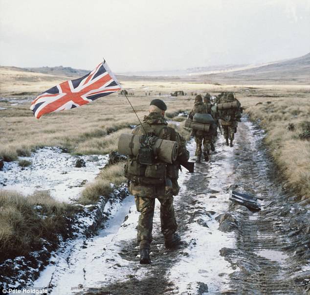
2 April 1982 Argentina re-occupied the Malvinas (Falkland) Islands, occupied by the British in the distant 1833 year. So the conflict went into an open phase.
According to Argentinean estimates, in the conflict over the Malvinas Islands, US intelligence satellites played a key role in favor of their traditional ally, the British.
Of course, the United States provided the British not only with military assistance, but it deserves more detailed consideration. It was precisely military assistance that was decisive in the military events that took place in the South Atlantic in April-June 1982.
"BIG BROTHER" FOLLOWING ALL
First of all, it is worth noting that the conviction that the US satellites monitor the conflict zone was present at all levels of the command of the Ground Forces, Navy and Argentine Air Force, but the Navy felt their presence more than others, therefore it is believed that the work satellites shackled the freedom of action of the Argentine ships at sea.
Admiral Anaya - Chief of the General Staff of the Argentine Navy - wrote in his official report on the results of the war that the Americans were conducting satellite surveillance in the South Atlantic, adding that this information came to him from various American admirals. Especially Admiral Anaya noted that since April 3, "the enemy had at his disposal data from the satellite about all the movements of the ground forces."
His Deputy Vice Admiral Juan José Lombardo, the commander of the South Atlantic region theater of commerce (and the commander of naval operations) pointed out in 1983 that “NATO was well aware of the situation at sea ... according to satellite data, they knew how many ships were at sea, although they could not determine what kind of ships they were ... I am sure that they had this information. ” He also stated that "in Norfolk (the largest naval base in the world owned by the US Navy) there is a map of the world on which all naval facilities are marked, and that the satellites continuously track operational data."
Rear Admiral Gulter Ayara, Commander fleet, was also sure that the enemy knew about their positions. According to him, this information was confirmed on May 3: "The Commander-in-Chief gathered us in the office and reported that the enemy absolutely accurately had current information from satellites about the location of our ships."
Thus, every naval officer at his level was convinced that the American satellites were working in the interests of the Royal Navy.
Later, this conviction that the US satellites are constantly monitoring the situation in the South Atlantic was reported to the political leadership of the country and public opinion: when the Belgrano 2 cruiser was sank in May 1982 by the British nuclear submarine Conqueror, it became obvious that it was possible due to from American satellites. The victims of the torpedo attack were 368 Argentines. Moreover, the cruiser was outside the zone of hostilities established by the British, so Argentina accused the UK of an act of aggression.
This was confirmed by the message of the official news agency Argentina TELAM, and the confrontation of the US ambassador to Buenos Aires, Harry Schlodeman with the command of the Argentine army, which had "accurate evidence" that "US satellites transmitted intelligence information that helped the British determine the Belgolano position and sink it. " The same was confirmed by the President of Argentina Galtieri to the President of Peru in the framework of the negotiations that took place then.
The military-political leadership, the media (which, of course, were subject to psychological struggle) were sure that nothing had escaped the surveillance of spy satellites that were over the South Atlantic. Evidence of this, obviously, was the sinking of the cruiser.
However, as of 1982, this was not the case at all.
ZORKY EYE IN ORBIT
In the eyes of the philistine, “spy” satellites were large telescopes that monitor the Earth’s surface, with the ability to transmit absolutely clear, high-resolution images to any corner of the globe, regardless of weather conditions.
Even if reconnaissance satellites had a great strategic usefulness, their operational and tactical capabilities (more than 30 years) would be limited, especially during the air-sea conflict, like the Malvinas conflict.
In April, 1982, the United States had three satellites of this type: one KH-8 (the Gambit-3 project) and two KH-11 (Kennan or Crystal). The work of KH-8 was stopped on May 23, it was replaced by KH-9 (“Hexagon”), which was launched on May 11. KH-8 and its replacement KH-9 had high-resolution cameras, but the film was delivered by parachute from orbit from a height of 160 km.
It is interesting to note that almost 65 km of KH-9 films were delivered to Earth in four different capsules, that is, the satellite could take a large number of images, but there were only four ways to deliver them to Earth.
As for the oldest KH-8, then we are talking about the mission 4352. 20 March 1982 was problematic for him to deliver the first two capsules with film to Earth - they remained in outer space. 23 May satellite was able to send the last capsule, in which were images taken at high and low altitudes, but, for unknown reasons, 50% of images were not read.
KH-11 can be considered the first modern satellite that saved images in digital format. But in 1982, the quality of his pictures was slightly inferior to KH-11 and KH-8 or KH-9, so the latter were also in orbit.
By the beginning of hostilities, the orbits of these satellites did not pass over the territory of the Malvinas Islands or Argentina. To expand the coverage area, the orbit of one of them, perhaps, KH-11-mission No. 4 was temporarily changed according to the statements of US Secretary of Defense Caspar Weinberger himself. It turns out that KH-9 could also take pictures in the conflict zone.
According to the calculations, KH-11, which followed its course from south to north, 45 minutes after working in the South Atlantic, had the opportunity to transfer images directly to the land station Manvis Hill, Yorkshire, UK. The station was under the control of the US National Security Agency and could directly coordinate the operation of satellites in higher orbits to establish uninterrupted communication.
At the beginning of April, 1982, the US Navy Minister John F. Lehman, Jr., stated that he "regularly studied the top secret pictures of the Malvinas Islands, recently taken during the flight through Argentina and fixing the slightest preparations for the defense." "Our satellites and other sources allowed us to occupy a privileged position, while the UK was building up its strength to go south," he said.
For their part, the British declared that in April they had American photographs only of South Georgia, and not of the Malvinas Islands and continental bases. In any case, this information was vital to the actions of the British in South Georgia.
Without a doubt, as one American admiral later stated, the big problem with satellite imagery was that "they provided strategic data, not tactical data." To perform operational tasks, these images needed to be transmitted to Earth, processed, analyzed, and linked.
In other words, the satellite filmed bases, airfields, military positions, infrastructure, etc., but these images could not contribute to the conduct of military operations in the air-naval theater of military operations, especially since the satellite could only take information at sea when it passed directly over this location. The situation was the same with the ground situation.
Another problem that the aforementioned admiral referred to was that “satellite photographs were irregular in nature and depended on weather conditions,” which was important in conditions of high clouds over the Malvinas Islands.
CIA EXPERTS COME TO WORK
In the United States, satellite images were analyzed by the National Center for Photo Processing - a photo analysis organization that was located in Washington and was subordinate to the Central Intelligence Agency (CIA).
In the 2010 year, the images taken in the 1982 year were declassified, and since the 2015 year, they are publicly available in the CIA database in Maryland.
From an analysis of almost 400 report sheets for the period from April to May 1982, it turns out that the activity of the US satellites was mainly (as a preventive measure) directed against the USSR, China and the Middle East. From this it is clear why the main targets were static civilian and military installations.
As for the conflict over the Malvinas Islands, only 12 objects were shot there, mainly airfields and ports, from which it can be concluded that the effectiveness of satellite observation was limited, which may have been due to the difficulty of processing photos constant heavy clouds.
Of course, this does not mean that during April-May 1981 of the year only data on 12 objects were processed, since the British could make their own analysis of the situation, especially from images from KH-11 sent directly to the UK. Without a doubt, now there is data by which it is possible to determine the performance of this spacecraft.
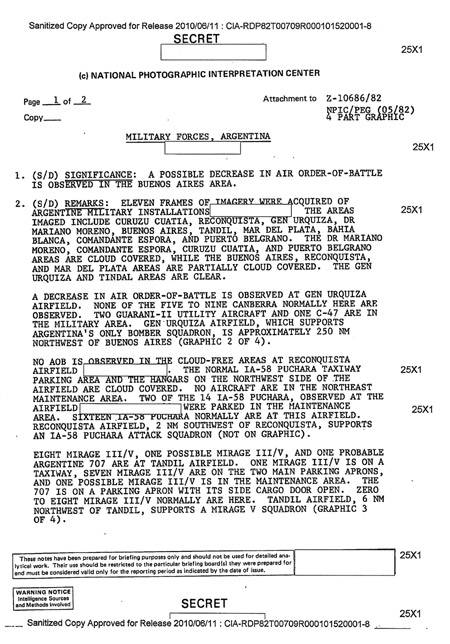
A copy of the declassified original of the CIA report from 5 May 1982, which was at the disposal of the British command.
Illustration provided by the author
Illustration provided by the author
It is also worth noting that the pictures were not sent directly to the combat units of the British. For example, the Royal Marines of Great Britain did not receive any pictures throughout the operation. Perhaps in the parts of the land forces on the islands, the situation was the same.
The pictures could be more useful when planning the operation “Pudding with raisins” (the landing of special forces in the vicinity of Rio Grande, an Argentinian island on Tierra del Fuego), but then only a small number of 1-scale shots were used: 50000, which covered both the Argentinean and Chilean parts islands.
Confirming the above, it is worth quoting Captain 1 of the rank of Nestor Dominguez, who is perhaps the main Argentine expert in military satellites, who says that "one could find a huge amount of evidence that the special forces could not receive intelligence data from visual observation satellites."
Thus, it can be concluded that this type of satellite did not play a significant role during the conflict over the Malvinas Islands, although it helped to collect the necessary data. However, other US military intelligence satellites provided appropriate assistance to the British during the conflict over the Malvinas Islands.
First of all, we can mention the White Cloud satellite system or the NOSS (National Oceanic Satellite System) used by the US Navy, and the ELINT radio intelligence system. Typically, such systems include three satellites that are capable of detecting electronic signals within a radius of 3200 km, being the primary means of reconnaissance by the US Navy. It should be added that, according to some data, the KH-9 and KH-11 devices were also used, which used small satellite groups with electronic reconnaissance equipment (“ferrets”) with similar capabilities, but only when they were sent to a ground target.
One of the satellites of the ELINT system played a remarkable role during the conflict, when on the evening of May 1 discovered the radio signal of the Argentine destroyer Type 42.
This information, promptly transmitted to the flagship of the British Navy Hermes (HMS Hermes), allowed the British to understand that the Argentine aircraft carrier, which was apparently accompanied by the destroyers of the Argentine Navy Hercules (ARA Hercules) and Santisima Trinidad (ARA Santisima Trinidad) ), is located nearby, take precautions and clarify its position for departure to a safe distance in order to escape from the impact of an aircraft wing aboard an aircraft carrier. British actions disrupted the planned attack of the Argentines on that day, and subsequently there was no such opportunity for a second attack.
On the other hand, among the radio intelligence satellites (COMINT), a satellite known under the code name "Vortex" (third in the series) is allocated, the main task of which was to intercept communications of the strategic communications system of the Soviet armed forces.
The US National Aeronautical Intelligence Agency (National Reconanissance Office) acknowledged that the satellite, launched in October 1981, was used to support the British. At that time, the satellite was used to intercept negotiations over Central America, but for several hours a day the antenna was redirected to the South Atlantic to intercept military communications from the Argentines, control of which was given to the British.
In addition, it is important to note that the Argentine military connection was intercepted on a regular basis (both by these satellites and by other means). And, worst of all, this information was also deciphered by the armed forces of the enemy. The chief of intelligence of the Armed Forces of the United Kingdom noted after the war in his conversation with his American counterpart that “we received the 90% of information through radio and radio intelligence”, adding that “radio intelligence (COMINT) ... has established itself as an invaluable tool (for extracting information - “NVO”) ”.
Thus, the radio and electronic reconnaissance satellites (SIGINT, a system that includes ELINT radio reconnaissance and COMINT radio reconnaissance), played a significant role in the conflict around Malvin.
In conclusion, we note that, in general, the US satellites over the South Atlantic had a certain, albeit limited, benefit in the British military actions. At the same time, it was SIGINT’s electronic reconnaissance satellites that made the greatest contribution to helping the British by working from space. Moreover, it should be added that visual intelligence could be conducted by shooting in rare cases and only fixed objects.
This analysis is an assessment of American aid to the British, which was required for lack of their own operational capabilities. This must be remembered in order to properly assess the parties involved in the conflict for the Malvinas Islands. The British fought in this war not themselves, but relying on the strong support of the United States.
Argentina
Report by the National Center for Photo Processing (CIA)
from 5 May 1982 of the passage of the American satellite over Argentine military targets
2010 / 06 / 11 authorized secret copy:
CIA - RDP82T00709R000101520001-8
SECRET
(c) NATIONAL CENTER OF PHOTO-WORKING
1 page from 2 Appendix to Z-10686 / 82
Copy NPIC / PEG (05 / 82)
4 DIAGRAMS
MILITARY FORCES, ARGENTINA
1. SIGNIFICANCE: IN THE AREA OF BUENOS AIRES, A POSSIBLE DECREASE IN THE BATTLE ACTIVITY OF THE AIR FORCE IS OBSERVED.
2. NOTE: 11 IMAGES OF ARGENTINA MILITARY OBJECTS (skip), INCLUDING THE KUATIA, RECONCISTIST AIR. GENE. URKISA, AER. MARIANO MORENO, BUENOS AIRES, AER. TANDIL AER. MAR DEL PLEASE, BAHIJA BLANKA, ESPORA COMMANDER, PORT BELGRANO. IN AIR AREAS. MARIANO MORENO, THE COMMANDER OF ESPORA, KUATU KUATIA, THE PORT OF BELGRANO HIGHED CLOUD; BUENOS AIRES, RECONKIST, AER. MAR DEL PLEASE - PARTIAL CLOUD. AIR AREAS. GENE. URKISA and AER. TANDYL - CLEAR.
DECREASE IN BATTLE ACTIVITY IS OBSERVED ON THE AERODROME OF GENES. URKIS. NORMALLY HERE FROM 5 TO 9 THE KANBERRA BOMBERS NOW WON'T OBSERVE. TWO SUPPORT AIRCRAFT “GUARANI-II” AND ONE C-47 OBSERVED. AERODROME GENE. URKIS, ON WHICH ARGENTINA IS THE ONLY SQUADRILLE OF ARGENTINA BOMBARDS, BASED ON, IS IN 250 SEA MILES NORTH-WESTERN BUENOS-AIRES (2 SCHEME OF CHIMNUMUM CHEMUMUMNUMUMUMNUMUMNUMUMUMNUMUMUMNUMUMNUMUM
IN THE AERODROM AREA OF RECONCIST AROUND-FREE AND BATTLE ACTIVITY IS NOT OBSERVED (skipping). STEERING ROAD, LOCATION OF THE IA-58 “PUTCHARA” AND ANGARA IN THE NORTH-WESTERN AERODROME AREA COVERED WITH CLOUDS. IN THE AREA OF TECHNICAL SERVICE ZONES IN THE SOUTHEAST OF AIRPLANES AIRPLANES ARE NOT OBSERVED. 2 FROM 14 IA-58 “GUNS”, OBSERVED ON THE AERODROME (pass), HAVE BEEN IN THE SERVICE AREA. NORMALLY AT THE AERODROM ARE BEACH 16 IA-58 “PECHARA”. RECONKIST AERODROM, LOCATED IN 2 MARITIME MILES FROM RECONKIST, IS THE BASIS OF THE SQUADRILLA OF IA-58 STARMER ARCHENTINA (NO ON SCHEME).
EIGHT “MIRAGE” III / V, POSSIBLE, ANOTHER ONE “MIRAGE” III / V AND ONE MORE, POSSIBLE, “BOEING-707” IS ON THE AIRFROM OF TANDIL. ONE MIRAGE III / V - ON A STEERING VEHICLE, SEVEN MIRAGE III / V - ON TWO KEY PARTS AND, POSSIBLE, ONE MIRAGE III / V IN A SERVICE AREA. "BOEING-707" - ON PARKING, SIDE TRIP HATCH OPEN. NORMALLY HERE IS TO EIGHT “MIRAGES” III / V. AERODROM TANDIL (AERODROME V SQUADRILLS OF MIRAGE Air Force ARGENTINA) IS IN 6 MARINE MILES OF THE NORTH-WESTERN TANDILA (CHART 3 FROM 4).
These data are prepared for instructional purposes and should not be used for analytical work. The use of data is limited to the purpose of preparing them for instruction,
they are valid only in the reporting period, determined by the timing of data preparation.
Attention!
Data prepared using intelligence sources and methods.
SECRET
2010 / 06 / 11 authorized secret copy:
CIA - RDP82T00709R000101520001-8
Information