Navigator Day of the Navy of the Russian Federation

38
If in Russia on January 25 you ask a question about which holiday is celebrated today, then the vast majority of people will remember, of course, about Tatyana’s day - the student’s day. But is Tatyana’s day only (as the main day of Moscow State University is celebrated) on January 25? Not only. January 25 is also a date that is directly related to the Russian fleet Russia, since on this day navigators of the Russian Navy celebrate their professional holiday. For the first time, January 25 was the official date for celebrating Navigator's Day in 1997 on the basis of a decree of the Russian president of July 15, 2006. The decree presented a list of military holidays in Russia and was called "On the introduction of annual holidays and professional days in the specialty."

Navigator Day of the Navy of the Russian Federation


Date has been selected according to historical prerequisites. On January 25, 1701, Peter the Great signed a decree on the opening of the country's first navigational (navigational) school. The navigational school was located, the need for the opening of which was ripe in connection with the emergence of Russia’s own fleet, in Moscow. The building of the school, which was called the "School of Mathematical and Navigational Sciences", was the Sukharev Tower.


Petrovsky's order assumed training in the navigational school not only of navigators, but also of artillerymen, naval engineers. In fact, it was a full-fledged multidisciplinary military school, in which prominent personalities of that time were engaged in teaching work: Jacob Bruce, Henry Farvarson, Richard Grace. This, as it is now said, qualified personnel attracted from abroad. In the navigation school, both Russian scientists and the military were engaged in teaching. One of the most well-known names is Leonty Magnitsky (Telyashin) - an outstanding Russian mathematician, the creator of the first in Russia mathematical reference book. By the way, from 1732, it was Leonti Magnitsky who headed the school.

In 1710, Russia publishes "Instructions and articles of the military appropriate to the Russian fleet." These instructions define the duties of officers in the navy. One of the sections speaks about the navigator service:

(...) so everyone has a rank, and he is responsible for his work, namely ... the navigator in what belongs to the ship.


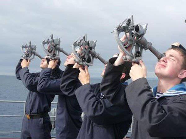
In the charter that appeared in Russia in 1720, the service of navigators in the fleet is regulated in more detail. So, onboard the ship, depending on the number of guns, the charter assumed the presence of one or two navigators and sub-navigators (the Petrovsky equivalent of the position of deputy ship navigator). The very same navigator position was defined as the average in importance between the skipper and the boatswain. Two navigators relied for the warship on which there were over 50 guns. The arsenal of tools that were at the disposal of the ship's navigator included: lots, hourglasses, magnets and magnetic hands (compasses), rulers, navigation charts and atlases, swirled, gradshtok.

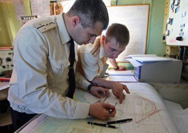
The duties of the navigator of Peter the Great's time included inspection of the rudder, maintaining the calculation of depths, wind speeds, currents, determination of the type of bottom soil (if this was possible with the depth available). Navigators became, in fact, both hydrographs and cartographers, putting marks on the currents, shoals, and contour of the coastline on the paper. Moreover, the navigator was obliged to conduct and teaching. If the ship was attended by students of naval schools and schools, the navigator had to pay attention for about one and a half hours a day to train them in navigation.

The final goal of the military navigator’s service was to act so that the ship could reach the final point of the route in the minimum time possible for its parameters. If during the trip the ship suffered a “navigational accident” (for example, ran aground), the result of which was the inability to effectively resist the forces of the enemy, then the navigator (if he survived) was sentenced to severe punishment. There were two variants of punishment: either hard labor or the death penalty (“fine of death”). The motivation for improving the quality of performance of official duties - the beyond!

The school of mathematical and navigational sciences opened by Tsar Peter until 1753 existed, having released over this time more than 5000 thousands of specialists in various fields of military and engineering activities, of which about 750 people became professional marine navigators.
The navigator service rightfully received the unofficial name of the “fleet view”. Without the work of military navigators, ships would indeed become "blind kittens" in the vast expanses of the sea. For obvious reasons, no maritime trip could not do without navigational labor and talent. It cannot even now, when the navigation equipment of the ships allows the crew of the ship to solve the most ambitious tasks, not paying attention to the weather conditions, the time of day and the nature of the operation. The appearance on board of ships of modern equipment makes the crew, and the navigator composition, including special requirements - the need not only to effectively use such equipment, but also to make the best decisions when a specific situation occurs depending on the task set by the command.

In this regard, a special role is played by the training of navigator calculations to ensure the safety of navigation, which are becoming more frequent in the Russian fleet. One of these trainings involved the use of an electronic navigation and information system “Alaska-H”, which allows you to simulate the passage elements of the straits in the presence of obstacles, such as shoals.


The system allows you to enter additional parameters that complicate the process of passing. As an example, exercises in the Baltic can be cited, when military navigators worked on the effective passage of the Great Belt Strait under unfavorable hydrometeorological conditions. Training was successful. The increase in the number of such trainings has a positive effect on the level of training for the crews of Russian Navy ships.

"Military Review" congratulates the navigators of the Navy on their professional holiday!
  • http://shturman-tof.ru
Our news channels

Subscribe and stay up to date with the latest news and the most important events of the day.

38 comments
Information
Dear reader, to leave comments on the publication, you must sign in.
  1. Fedya
    +11
    25 January 2015 08: 12
    I read somewhere, while visiting a Ross ship, one young American officer laughed when he saw the sextant there. What was criticized by the older: When all the devices on board fail, you will be ready to give everything for it! And they (Russians) do not need to do this, they already have it!
    1. +11
      25 January 2015 08: 36
      Let them "laugh" for now ... let's look at their "faces" when the GPS "goes out" - "the one who laughs last laughs well." Happy navigator's holiday, don't throw the sextant behind the stove!
      1. +7
        25 January 2015 09: 40
        By the way, in 1988 we already used GLONASS to its full potential, despite the fact that the satellite constellation was not complete, our regions had enough with a margin. But they didn’t hide the sextant behind the stove. laughing
    2. The comment was deleted.
    3. ICT
      +6
      25 January 2015 08: 45
      Well, not sailors, of course, but such a still life is also in use
      1. +2
        25 January 2015 09: 35
        Quote: TIT
        Well, not sailors, of course, but such a still life is also in use

        The set is not complete + a square, a windbreaker and a pencil
        1. VAF
          VAF
          +5
          25 January 2015 09: 47
          Quote: saksan
          The set is not complete + a square, a windbreaker and a pencil


          Well, with a wind turbine, you dear .. strongly got excited wassat because of the size ... it will not fit into the cabin lol , plus a lot of phosphorus .. harmful bully
          So only HP (plus it already exists in a knee pad, built-in)
          The square is the same ... back and forth .. since the entire "grid" (already graduated is applied directly to the map)
          Moreover, to measure the azimuth at 20 or 40 kilometer wassat

          And here’s a pencil .. that’s yes .. +! drinks
          1. +1
            25 January 2015 11: 14
            С
            Quote: vaf
            Quote: saksan
            The set is not complete + a square, a windbreaker and a pencil


            Well, with a wind turbine, you dear .. strongly got excited wassat because of the size ... it will not fit into the cabin lol , plus a lot of phosphorus .. harmful bully
            So only HP (plus it already exists in a knee pad, built-in)
            The square is the same ... back and forth .. since the entire "grid" (already graduated is applied directly to the map)
            Moreover, to measure the azimuth at 20 or 40 kilometer wassat

            And here’s a pencil .. that’s yes .. +! drinks


            I AGREE: The listed FBA kit is not needed, but things are necessary for the navigator BTA or YES, as well as the navigational bag full of flight cards and books of all ports along the flight route.
          2. +1
            25 January 2015 15: 18
            Forgot about the curvimeter and compass (stress on "a"). How can it be without them!
        2. +2
          25 January 2015 11: 20


          The compasses have been forgotten!

          1. 0
            25 January 2015 15: 25
            Quote: crambol
            The compasses have been forgotten!

            Air navigator compass unnecessarily.
            1. +5
              25 January 2015 18: 35
              Quote: saksan
              Air navigator compass unnecessarily.

              Sailors without a compass gauge - a pipe. For some reason, no one remembered the parallel ruler either! And you should not forget the protractor triangle, the stopwatch, too. And you can’t do without a protractor in minesweeping. Tracing paper is also needed, otherwise you can’t decide on the depths.
              So - with a holiday, navigator of the fleet and aviation! (Airborne - he is also a fleet, especially born a naval officer).
      2. +4
        25 January 2015 09: 35
        This would be a pencil, an eraser, a protractor, a pair of compasses and a parallel ruler. Each self-respecting navigator, these items are individual, like personal hygiene items. :)

        But in the photo, the cushioning tool is not serious. The protractor should be normal, iron, the ruler is not visible at all, the pencils are "wrong". Who can say how it is now in the navy?
        1. VAF
          VAF
          +4
          25 January 2015 09: 51
          Quote: Andrey NM
          This would be a pencil, an eraser, a protractor, a pair of compasses and a parallel ruler. Each self-respecting navigator, these items are individual, like personal hygiene items. :)


          Our Transport workers and Strategists have practically such a "gentleman's set" .. not for nothing I call the navigator .. "a bag with amendments." they also carry with them Lists, Regulations and Collections wink

          But it's his own business .. this "boorish brat" knows how to do it ... without any x ... it would be very difficult, but in general without navigational training ... nowhere!

          Therefore, from the heart of Navigators (navigators) Sea with a HOLIDAY !!! soldier drinks
          1. +4
            25 January 2015 10: 12
            We had a teacher at the navigational department, a captain of the 1st rank of Soldatov, during the war he was a navigator of a submarine, and then a flagship navigator of a submarine brigade in the Baltic. But over 70% of the boats died there. He was very respected.
            And in due time many navigators got into aviation. I have friends after the VVMUPP, the twin brothers "thundered" into the regiment on Tu-16 in 1986, barely escaped, and drank on purpose. I do not know how they were going to be used there and why it happened. They were given instructions after school at the disposal of the headquarters of the Federation Council.
        2. +1
          25 January 2015 15: 36
          Quote: Andrew NM


          But in the photo, the cushioning tool is not serious. The protractor must be normal,


          The tool in the photo, which is the most serious: NL-10, HP (monkey) appeared later.
          1. +1
            26 January 2015 11: 32
            saksan, what instrument are you talking about? Probably a flying instrument? I meant the photo in the article, where the drop on the map is not clear what. I had a set: a navigator's protractor, so metal, in a wooden case, inside the case is black velvet, a parallel ruler, always a set of Koh-i-Noor Hardtmuth pencils of different hardness, erasers of the same company. Then there were problems with a normal drawing tool, but my mother (!) Got me somewhere a large drawing room, also Koh-i-Noor, there was everything, including the drawing pen for the ink. Then this Czech office was generally considered cool. The cooking room is still alive and working. Slide rule, a stopwatch with two hands, a textolite board lined with a table, it was convenient to write measurements on it with a pencil or lead goals at the top ... Yes, a lot more. Moreover, I am not a navigator. And the navigators still had all sorts of "little things" beyond that. I gave the navigators a ruler with a protractor when I left. Sometimes I regret that it was possible to make such a memorable stand at home ... I wonder what is being done in Gadzhievo and Olenya now ...
            1. 0
              26 January 2015 21: 47
              Quote: Andrew NM
              saksan, what tool are you talking about? Probably about a flying instrument?


              So for sure! On the map of the fighter lies the NL-10. NL-10 navigation line
      3. 0
        26 January 2015 00: 57
        joke about sorry beard

        They wrote off a navigator from flying work. He went to his wife's homeland, in the village. The wife asks the collective farm chairman to take her husband to work, the chairman asks the navigator:
        - What can you do?
        - I read the maps, pave the tracks, I think it's good.
        - We have only playing cards, one track to the district center, but we need an accountant. You see a herd of cows in the field, count how many goals.
        The navigator looked at the herd, took out the NL-10 (navigation bar), joked and said:
        - 52.
        Checked, really everything is correctly counted.
        “And there is a large herd of cows on the horizon, how many are there?”
        The navigator looked at the herd, took the NL-10, joked and said:
        - 325.
        We checked, again everything came together. They bit the collective farmers, drove all their cows, count, they say. The navigator looked, took the NL-10, joked, figured out what was happening and said:
        - 1568.
        Two days double-checked, twice lost count, but it turned out all right.
        Chairman:
        “I take you to work, but tell me how you do it.”
        - Nothing complicated, I count the number of nipples, divide by four and take the correction for eggs.
    4. +3
      25 January 2015 10: 24
      I did not know that there was such a holiday, but although I am far from the Navy, I still sincerely congratulate you)
    5. +8
      25 January 2015 10: 51
      Quote: Fedya
      I read somewhere, while visiting a Ross ship, one young American officer laughed when he saw the sextant there. What was criticized by the older: When all the devices on board fail, you will be ready to give everything for it! And they (Russians) do not need to do this, they already have it!

      "They say in Ryazan, mushrooms with eyes ..." Do not repeat other people's nonsense because you yourself look a fool.
      On the bridge of the aircraft carrier USS Nimitz (CVN 68), Red Sea 04.09.2013/XNUMX/XNUMX

      The navigator (according to their quartermaster) of the 1st class Clarence Ilijic, using a sextant, measures the distance between the USS Rushmore UDC (LSD 47) and the Australian supply ship HMAS Success (OR 304), during the RIMPAC exercises on July 16.07.2014, XNUMX.

      Well, a brain break for racists, blacks are also able to use the sextant, class 2 navigator Darren Maple on the bridge of the destroyer URO USS Farragut (DDG 99), Mediterranean Sea, 16.09.2012.
      1. +5
        25 January 2015 11: 44
        The Americans sectarian is not right, some small. Either our business, and you take the height of the star, and if necessary, you can fight off the enemy.

        My question is, what does this little black one intend from cutting through thick sloping glass? Or am I not catching up with something? And not a single fighter with a stopwatch and a tablet for recording measurements ...
        1. +3
          25 January 2015 12: 43
          Quote: Andrey NM
          My question is, what does this little black one intend from cutting through thick sloping glass? Or am I not catching up with something?

          The sun is looking.
          Quote: Andrey NM
          And not a single fighter with a stopwatch and a tablet for recording measurements ...

          Like so?
          1. +4
            25 January 2015 14: 04
            Well, kind of like that. The stopwatch is synchronized with the chronometer (the chronometer also has its own corrections), Greenwich Mean Time, well, or another exact source of time is taken, fortunately, now there is a lot of everything (we didn't have it), then a certain number of measurements are made, then the average time and average height, then you run to the books of YOU or TVA, you bring the bearing by the cruise-bearing method to one time, all this on the tablet ... Phew, we have decided. And before that, you still choose the stars, which you will "shoot" at. And the "Astronomical Yearbook of the Sea" should not be forgotten. And do not forget to take into account your height above sea level. And all sorts of amendments. Wow, so many years have passed, but I remember something. In service, these methods were used only for training just in case, more often on the moon.

            I write as a poor student, then a "sectarian", then a "sextant" ... laughing
            1. +4
              25 January 2015 19: 03
              Quote: Andrey NM
              This is on a tablet ... Uh, we decided.
              Nope, Andryush, haven't decided! Forgot to "overclock the error", the easiest way is in the corners. Then you report the discrepancy and amendment of the new course. If the commander is on the bridge - to him for approval once every 1 hours. Actually, for the watch, but we did it in 2 hours. And despite the fact that the CEP received a place from space, we were instructed to determine 2% of locations by autonomous means (VAS, TVA, MAE).
              1. +3
                25 January 2015 20: 08
                I agree, a big and bold plus. Only it was necessary to paint so completely in detail? About the medians of the triangle, too? Then, in the end, it would be nice to write down the results of witchcraft in a journal. I’ll erase the buttons on the keyboard. laughing
                A fellow-student navigator lives nearby ... I congratulated him today. Still, in civilian life, it sucks for the navigator to settle in after service if there are no leads. If a miner and a rocket scientist in their diploma, in addition to the main specialty, also has an "electrical engineer", then navigators everywhere have an "engineer-navigator", at least 30 years ago. So my friend in the dashing 90s quit KBCH-1, and then even more than 10 years as a district police officer, so as not to be left without housing ...
                1. 0
                  26 January 2015 06: 12
                  Quote: Andrew NM

                  A fellow-student navigator lives nearby ... I congratulated him today. Still, in civilian life, it sucks for the navigator to settle in after service if there are no clues. If a miner and a rocket scientist in their diploma, in addition to the main specialty, also has an "electrical engineer", then navigators have everywhere "boat engineer", at least it was like that 30 years ago. So my friend in the dashing 90s quit KBCH-1, and then for more than 10 years the district police officer, so as not to be left without housing ...


                  In the diploma of the graduate of ChVVAKUSH it is written downnavigator engineer , well, where does such a graduate work in civilian life? angry I am waiting for proposals from potential "employers".

                  ONE proposal has already been received — tails in the herd count. wassat
        2. +2
          25 January 2015 18: 44
          Quote: Andrey NM
          And not a single fighter with a stopwatch and a tablet for recording measurements ...
          He measures the distance to keep his place in the ranks. It is possible through glass. but this is only with the use of RES No. 1. (complete prohibition of work on radiation).
          1. +3
            25 January 2015 20: 22
            Clear. We didn’t go in line, that’s all. Those. he determines the angular height of the target? Is there any table? Then there for this distance the distortions do not strongly affect, I think so.
        3. +3
          25 January 2015 20: 34
          Quote: Andrew NM

          My question is, what does this little black one intend from cutting through thick sloping glass? Or am I not catching up with something? And not a single fighter with a stopwatch and a tablet for recording measurements ...


          He has a 0 degree count on his limb. he is looking at the horizon. most likely a vertical angle is taken to determine the distance.

          or maybe just posing ...
          We somehow went through the Aden with security, so all the guards were necessarily photographed with a sextant ... smile
      2. Fedya
        0
        25 January 2015 16: 43
        For what I bought, for that I sell it! I didn’t come up with a word!
    6. +2
      25 January 2015 16: 18
      "Navigator, boorish nature,
      To the wine and the women eagerly hunting!
      And therefore, do not let the assembly go,
      For having drunk drunk, a rowdy to commit much.
      And for the knowledge of the rare and cunning sciences
      Consider an officer and grant him an altyn. "

      It seems from the decree of EIV Peter I
  2. +13
    25 January 2015 08: 47
    ... let's look at their "faces" when the GPS "goes out" - "the one who laughs last laughs well." Happy navigator's holiday, don't throw the sextant behind the stove! ..

    That's exactly ..! Happy holiday colleagues! Sometime in our cadet wall newspaper "32 rumba" there was such a saver - a slogan, it was believed that these were the words of Peter I from his decree:

    "... And navigators, although the people of dastardly origin and for vodka and women are very eager for vodka and women, they are understandable in the sciences of navigation. And therefore - let them go in the wardroom and grant them ranks ..." laughing laughing drinks
  3. +11
    25 January 2015 08: 55
    Happy holiday, navigators !!! An anecdote about the fact that everyone should do their own thing.
    There is a ship on the sea ... A mechanic comes to the captain and says that let's give up duties for a week! He shrugged, come on .... Three days pass. The captain leaves the engine room and says that the bearings are warming from the load. Why don’t you know? The mechanic answers: why don’t they bask, we’ll go through the desert for a day ...
  4. +5
    25 January 2015 09: 20
    All navigators with a holiday !!! As well as all graduates and students of VVMU them. Frunze (SPbVMI Marine Corps) with the 314th anniversary of the founding of our alma mater. drinks
  5. +12
    25 January 2015 09: 27
    Everyone who mastered TVA, YOU, MAE, poked his fingers at Kleister-N, used maps with position lines for all kinds of "omegas", etc., with sextants and stopwatches yelled "Tovs! Zero!" quasi-coordinates, who caught the bearing in the fog of the winter night coast and did not sleep for days on alarms and the command "GKP, BIP, navigator - readiness N1", hanging out in the ranges and narrows - happy holiday! And our "Chinese", "Romanian" and "Maslopup" hello! I think everyone will support.
  6. +4
    25 January 2015 09: 54
    Synonyms - navigator, fornication.
    The first navigator-fornication in Russia was Ivan Susanin - Lyakhov led into the swamp.
    The second by harlot is the sailor Zheleznyak. He went to Odessa and went to Kherson.
    In aviation they cannot be counted either. Swam, pah, flew - we know!
    1. 11111mail.ru
      +6
      25 January 2015 13: 47
      Quote: saksan
      The first navigator-fornication in Russia was Ivan Susanin

      Yeah, and the first female aviator = Baba Yaga.
      1. +2
        26 January 2015 04: 18
        And the first navigation device - a ball of thread from Ivan Tsarevich ...
  7. +4
    25 January 2015 10: 59
    Why did he say pah. It was like this: they came to Khabarovsk from Kamchatka on the An-26, they settled down and went to settle in a hotel, there were a flight engineer and a mechanic on board to refuel the plane, it was necessary to add 3,5 tons, TK came, but he had only two tons were available. Having given it, TK-22 left
    Bortachiki, waiting for him several times, joined the canister in the warehouse for fuel, the winter canister, the winter is still cold. After closing the plane and putting it under guard, we left for the hotel, a day later we left for Magadan. When you enter Magadan’s area of ​​responsibility, the remainder lights up fuel 600kg.
    That's all. It turned out that there wasn’t enough fuel before Magadan. The nearest Okhotsk was also in the last drops. The sea below was flooded with ice, but I don’t feel like swimming, but we prepared rafts just in case. how to get out with a request for an intermediate, unscheduled landing, a radiogram came that Magadan56 closed for meteo reception, we were offered to follow in Okhotsk. That's how we saved ourselves from an unscheduled font in the Sea of ​​Okhotsk.
  8. +3
    25 January 2015 11: 06
    With the holiday of all specialists БЧ-1 of the Navy of the USSR and the Russian Federation !!!!!
  9. +2
    25 January 2015 11: 22
    Congratulators sincere congratulations.
  10. The comment was deleted.
  11. +3
    25 January 2015 11: 27
    Forgot to add, my favorite writer is Viktor Konetsky. At one time had fun over his books.
  12. +1
    25 January 2015 11: 27
    Forgot to add, my favorite writer is Viktor Konetsky. At one time had fun over his books.
    1. +2
      25 January 2015 11: 37
      And also Jim Lloydovich Patterson, the same child from the movie "Circus", a graduate of the navigational faculty of VVMUPP, a poet and writer.
      1. +1
        26 January 2015 04: 20
        ... and also Vlentin Pikul. True, VVMUPP was then only a preparatory school.
  13. +4
    25 January 2015 12: 34
    All navigators with a holiday! Well, no errors, no errors in the work!
  14. +7
    25 January 2015 14: 12
    Congratulations on the holiday, gentlemen navigator. For many years, under my leadership, RIRV JSC (former Institute 93) has been creating radio navigation systems. RNS "Route", "Tropik", OJSC MKB "Compass" (formerly just MKB "KOMPAS") have created receivers. He has published many textbooks and published monographs, incl. "Marine Radio Navigation". I remember a case called Admiral Gorshkov, then he was located on Kozlovsky Lane. And my ministry was located on the street. Kirov. I reported to my Minister, to the car and to the admiral. And he from the doorway to me: "Do you know that the squadron commander reports to me that according to the readings of the instruments, all the ships were on the ground in coordinates?" "Comrade Admiral, allow me to report": I answer. "Well, and why?" I explained everything that our ships used the American LORAN RNS, and the Americans introduced delays in the emission of the signal from the leading station in the evening, they did not tell us, but informed their own in advance. After all, I asked to install the Mediterranean chain, but the Government did not give the go-ahead. Then, however, everything was corrected. And chains appeared in the Far East, on the Northern Sea Route, in the Baltic, on the Black Sea. With the arrival of Gorbachev and Yeltsin, everything was destroyed. Now we are slowly starting to recover. One cannot rely on one SRNS "Glonass", there must always be backups. I have the honor.
    1. +4
      25 January 2015 17: 43
      Was there three colored arrows on Laurent showing the amplitude values ​​for the position lines on the map? The system was called "Loran-S". The last time I was poking around with her was in 1986. Sometimes the readings of one chain were not, then they were determined by two. I don't remember anymore, then they never used it, but it was interesting with all these letters, flowers and numbers. We were told that it would not be useful, just in case.
  15. +5
    25 January 2015 15: 17
    7 under the keel, calm weather and clear skies. Congratulations, but I will not drink! Everything and for all only on the 23rd and day of the Navy, otherwise the region !!! smile If all OUR holidays and days of specialists are celebrated, health is definitely not enough! wink
  16. +3
    25 January 2015 19: 46
    Quote: Andrew NM
    The Americans sectarian is not right, some small. Either our business, and you take the height of the star, and if necessary, you can fight off the enemy.

    My question is, what does this little black one intend from cutting through thick sloping glass? Or am I not catching up with something? And not a single fighter with a stopwatch and a tablet for recording measurements ...


    Used both American and German. But, I think our verified CHO-T is the best!
    1. +2
      25 January 2015 20: 44
      Quote: Navigator2013
      Quote: Andrew NM
      The Americans sectarian is not right, some small. Either our business, and you take the height of the star, and if necessary, you can fight off the enemy.

      My question is, what does this little black one intend from cutting through thick sloping glass? Or am I not catching up with something? And not a single fighter with a stopwatch and a tablet for recording measurements ...


      Used both American and German. But, I think our verified CHO-T is the best!


      ours is really better. and now you can’t meet either American or German- MADE IN CHINA.
  17. +4
    25 January 2015 19: 51
    I am a military navigator. But, I will tell you a case from the life of civil shipping. At the end of the 90s, it was necessary to drive from Kamchatka to India the used boat for scrap metal, which was once a proud diesel-electric ship. Before leaving the ship, the shipowners removed all the slightest working modern navigation equipment, leaving the Don radar, 127-mm magnetic compass, and SNO-T sextant. I foresee the smiles of fellow skeptics, but I will make a reservation there were travel and general maps. According to the terms of the voyage assignment, fuel for the transition had to be taken outside the 200-mile zone of the Russian Federation. In this regard, the rendezvous point with the tanker, which was supposed to give us fuel, was chosen 200 miles southeast of Cape Lopatka, the coordinates of this point were agreed with the captain of the tanker, which followed from China to Canada. In short, I go to the rendezvous point, the radio operator calls the tanker to the HF, confirms our arrival. The tanker reports that due to an engine breakdown, it is delayed by 40 hours. Well, we had to wait, we are drifting. The month of August, the weather is calm, the ocean swell is about 2 meters, but gentle, even pleasant with a prolonged smooth rolling. We are in the center of the anticyclone. Above us during the day there is a blue sky and the sun, at night the stars are like in a planetarium. But, there is NO HORIZON !!! Warm air above cold water caused visibility to decrease to 500, well, a maximum of 1000 meters. There is no horizon line and that's it. I ordered the watchmen to call me to the bridge as soon as the horizon appeared. But, the ocean hid its shape. The second day of our drift is approaching, the tanker is already on its way, and I already doubt my position even in the first approximation, at best, putting my palm on the map, I could say - we are here! The fact is that the sailing directions describe more or less accurate parameters of ocean currents only at a distance of up to 100 miles from Kamchatka and the Kuril Islands, therefore the reliability of the current calculated coordinates became lower and lower. So we urgently need a "place" !!! recourse Otherwise, the tanker will look for us long enough. Direction finders at that time have already been canceled, and naturally removed.
  18. +5
    25 January 2015 19: 52
    Sun overhead, low-lying fog. Then I remembered that once in the course of nautical astronomy, the teacher told us about the so-called "Arab method" of measuring the heights of the Sun with a sextant in reverse azimuths (from the back) through the zenith from the reflection of a star in a vessel with oil. I call the mechanic - a large pan of used oil is installed on the deck, a beautiful black reflective mirror surface. I become facing the pallet and my back to the Sun. An executive officer with a stopwatch, a pencil and a notebook - performing "tovs-zero". Mechanics keep an eye on the oil pan, their good, and so to speak, also participate!
    So started. what He took the Sun from behind and "pulled it" down through the zenith, but not to the horizon, but combining it with the reflection in the oil bath. The entire crew gathered on the sidelines, observing the magical actions of the shaman group - the navigator's crew, led by the captain bent over in the opposite direction with a tricky object in his hands, equipped with some kind of mirrors. fellow Thus - a series of 10 heights and the result was an averaged line of position. Two VLPs before the climax of the Sun, two after. By that time, in my life, because of my love of astronomy and computing, a laptop had already appeared. Therefore, the averaging of the measured heights and the calculation of the VLP were simplified and accelerated, incomparably before the TVA and the YOU. By two o'clock in the afternoon, I already had the coordinates of our place, which were 42 miles northeast from the start point of the drift.
    The tanker captain, having arrived at the calculated coordinates of the beginning of our drift, naturally did not find us there, even using the radar. He suggests starting the search using the expanding square method, but I’m offering him a counter-proposal - follow the point with the coordinates observed in such a strange way. What was his surprise when, after an hour and a half following in a given direction, he calls me and screams I see the goal! Next, we identified by several maneuvers and met. drinks That's how navigational science came in handy when there were no Loran, GPS, GLONASS devices.
    1. +3
      25 January 2015 20: 41
      So how many times did he take measurements? Twice? And then the demolition was taken into account to bring the bearing to the second measurement? Just wondering. And we tried to write programs on the BASIC for calculation on the Spectrum and Electronics BK-010, they soldered them on the knee, and before that we distorted them on a programmable calculator.
      1. +1
        25 January 2015 21: 07
        Quote: Andrew NM
        So how many times did he take measurements? Twice? And then the demolition was taken into account to bring the bearing to the second measurement? Just wondering. And we tried to write programs on the BASIC for calculation on the Spectrum and Electronics BK-010, they soldered them on the knee, and before that we distorted them on a programmable calculator.


        I doubt that the strong demolition was, nevertheless, they lay in the drift, the weather was calm. in this case, an error of 5 or even 10 miles is not critical, because they were found using the radar.
        and I have all the formulas for calculating the height of the star and azimuth were clogged in the calculator. it took a couple of minutes to calculate the drug.
      2. +1
        25 January 2015 22: 15
        He made height measurements in a series of 10 h in each series to equalize measurement errors (pitching, oil flow, distortion of the reflection of the solar disk on the oil surface, all heights in the series led to one moment. Simultaneous overhead lines led to one zenith, taking into account the northeast flow with an estimated speed of 1 knot. Given the subsequent comparison of the coordinates with the satellite location of the tanker, the error in the place was 1,6 miles.
  19. +4
    25 January 2015 20: 38
    Well BCH - once with the Holiday! But I remembered such a joke .... In the seas, the political officer with battle sheets got out ... that would draw every day ..... Well, at the top, as it should be. ", for the rocket ships -" Every missile on target! "... And our navigator, Vova D., says to the deputy: - And what should we write ..." Every compass is in * oo! "? .... Central just lay down ....................... Once again, happy holidays ... And seven feet .......... ..
  20. +1
    25 January 2015 20: 41
    And here’s a pencil .. that’s yes .. +! drinks

    Quote: vaf
    Quote: saksan
    The set is not complete + a square, a windbreaker and a pencil


    Well, with a wind turbine, you dear .. strongly got excited wassat because of the size ... it will not fit into the cabin lol , plus a lot of phosphorus .. harmful bully
    So only HP (plus it already exists in a knee pad, built-in)
    The square is the same ... back and forth .. since the entire "grid" (already graduated is applied directly to the map)
    Moreover, to measure the azimuth at 20 or 40 kilometer wassat

    And here’s a pencil .. that’s yes .. +! drinks

    Happy holiday to all sea captains (both future and current)! I read your recommendations, well done. But, I will add my own "joke" problem (as sometimes to my cadets).
    The task is to find a direction to your ship (boat) at sea, if even a compass is missing?
    PS The answer is, to get your needle (sewing, hidden in a pea jacket), to pierce it in any cork, carefully convey (as they were on duty) to the water (but not to the iron mug) ... and it will certainly turn its nose ...! hi
  21. +4
    26 January 2015 06: 33
    Navigator - boorish offspring,
    to women and wines, however,
    for knowledge of the sciences of cunning navigational
    to admit to the wardroom and bring the cup.
    (Peter I)
    Happy holiday navigators !!! drinks

"Right Sector" (banned in Russia), "Ukrainian Insurgent Army" (UPA) (banned in Russia), ISIS (banned in Russia), "Jabhat Fatah al-Sham" formerly "Jabhat al-Nusra" (banned in Russia) , Taliban (banned in Russia), Al-Qaeda (banned in Russia), Anti-Corruption Foundation (banned in Russia), Navalny Headquarters (banned in Russia), Facebook (banned in Russia), Instagram (banned in Russia), Meta (banned in Russia), Misanthropic Division (banned in Russia), Azov (banned in Russia), Muslim Brotherhood (banned in Russia), Aum Shinrikyo (banned in Russia), AUE (banned in Russia), UNA-UNSO (banned in Russia), Mejlis of the Crimean Tatar people (banned in Russia), Legion “Freedom of Russia” (armed formation, recognized as terrorist in the Russian Federation and banned), Kirill Budanov (included to the Rosfinmonitoring list of terrorists and extremists)

“Non-profit organizations, unregistered public associations or individuals performing the functions of a foreign agent,” as well as media outlets performing the functions of a foreign agent: “Medusa”; "Voice of America"; "Realities"; "Present time"; "Radio Freedom"; Ponomarev Lev; Ponomarev Ilya; Savitskaya; Markelov; Kamalyagin; Apakhonchich; Makarevich; Dud; Gordon; Zhdanov; Medvedev; Fedorov; Mikhail Kasyanov; "Owl"; "Alliance of Doctors"; "RKK" "Levada Center"; "Memorial"; "Voice"; "Person and law"; "Rain"; "Mediazone"; "Deutsche Welle"; QMS "Caucasian Knot"; "Insider"; "New Newspaper"