In the US, demonstrated a new technology tactical table

28
At the recent Modern Day Marine exhibition in Quantico (Virginia), the US military demonstrated the technology of a new tactical (or “sand”) table, reports Gearmix with reference to an article published on the Army-technology website.

In the US, demonstrated a new technology tactical table


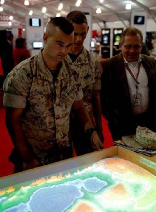
The article notes that "the ARES developed tactical augmented reality table (ARES) contains a laptop connected to the projector and Microsoft Kinect."

The design uses inexpensive and affordable commercial technologies that replace cards and threads traditionally used in sand tables with a projected image of the landscape and army units. Any given terrain in a short time can be recreated in detail.

"A computerized tactical table can give the military a wide range of new capabilities, including the technology of connecting two tables, which can be separated by many hundreds of kilometers," the publication says.

By linking two tables, you can conduct strategic games on them. And such an approach, the publication considers, “will be very realistic, since the two armies will not be able to see each other until they are within sight of the enemy.”

Soon the table will be closed tests, which will be held at the Basic School in Quantico.
28 comments
Information
Dear reader, to leave comments on the publication, you must sign in.
  1. +1
    3 October 2014 14: 25
    Grandmasters, damn it, and we have a horse in stock ...
    1. +6
      3 October 2014 14: 32
      Invented naval battle through keenect ... nano-technology!
      1. +1
        3 October 2014 14: 59
        Quote: Telakh
        Invented naval battle through keenect

        And they probably fight with gamepads. As I understand it, the warriors decided to fuse their small-soft "magazine version of Microsoft Surface. It looks like they have their own Nanotoli Chubes." laughing With respect.
        1. The comment was deleted.
          1. The comment was deleted.
    2. +7
      3 October 2014 14: 33
      It would be interesting if you put beacons on each soldier and equipment - so that on the map in real time everything could be seen where anyone is.

      On the other hand - they crack the signal - and on the enemy’s table there will be an arrangement of troops
    3. The comment was deleted.
    4. +2
      3 October 2014 15: 39
      The mattress covers came up with a good thing. Our bright heads should do the same for our military.
      1. 0
        3 October 2014 19: 14
        Quote: Thought Giant
        They came up with a good thing

        What is the table - such is the "chair" ...
    5. 0
      3 October 2014 23: 33
      Aha! "Knight's move on the head" (c)
  2. +5
    3 October 2014 14: 26
    another game "Heroes"
  3. +4
    3 October 2014 14: 31
    a wide range of new features, including the technology of connecting two tables, which can be separated by many hundreds of kilometers

    And none of the creators knows about the existence of online games ?!
  4. zavesa01
    +4
    3 October 2014 14: 31
    Step-by-step strategy. And the UAV, "remove the fog of war."
  5. +10
    3 October 2014 14: 32
    )) ... As a child, we made such awesome "tables" in an ordinary sandbox - all of us are envious good ... And when someone else brought tanks too - the slaughter was WELL fellow
    1. +2
      3 October 2014 15: 32
      And then the drunk janitor Uncle Petya came and drove everyone with his big broom (imitating the beginning of a nuclear war) wassat
      1. 0
        3 October 2014 19: 10
        Wah ha-ha ... laughing good
        We got older boys ...
        Imitating the beacons of democracy and “trampled underfoot” all tactical developments ...
  6. +20
    3 October 2014 14: 35
    Any given area in a short time can be recreated in detail.
  7. 0
    3 October 2014 14: 53
    Valuable "device", otherwise all the tanks are in the sandbox! laughing
    Switching from plasticine cartoons to computer ones.
    Okay, one fig, there’s always a spring from Toyota for any geri geri! wink
  8. 3vs
    +1
    3 October 2014 15: 08
    "By linking two tables, you can play strategic games on them."
    All play toys.
  9. +3
    3 October 2014 15: 11
    If you stop the banter, then this is a very serious technology that can greatly help command and control. It makes sense to think about an analogue.
    1. +6
      3 October 2014 15: 27
      Quote: Pacifist
      If you stop the banter, then this is a very serious technology that can greatly help command and control. It makes sense to think about an analogue.

      These are all beautiful candy wrappers. The standard card at the headquarters is a little worse and works in the light of the smoker from the sleeve.

      Most importantly, timely and accurate information about the tactical situation, the condition of their units, enemy forces and the transfer of orders back. And put a virtual icon or stick a pin with a flag - this is the tenth thing.
      If there is no information from the site of the operation, you should at least hang all laptops - there will be no use.
      1. Retarg
        +2
        3 October 2014 16: 52
        Most importantly, timely and accurate information about the tactical situation, the condition of their units, enemy forces and the transfer of orders back. And put a virtual icon or stick a pin with a flag - this is the tenth thing.
        If there is no information from the site of the operation, you should at least hang all laptops - there will be no use.


        And imagine the information being displayed on the table in real time.
    2. 3vs
      -1
      3 October 2014 16: 25
      And how do you imagine this crap in the dugout or in a tent in the desert?
      1. Retarg
        +1
        3 October 2014 16: 52
        And how do you imagine this crap in the dugout or in a tent in the desert?


        Okay, what's wrong with that?
  10. +3
    3 October 2014 15: 24
    For "Sea Battle" 2 sheets of paper in a box are enough. And also nothing is visible from each other. And even a little cheaper.
  11. +1
    3 October 2014 15: 43
    In principle, if you invest more ideas in this matter, then there will be an excellent training ground for training officers, and ordinary soldiers with the work of equipment.
  12. Everest2014
    -1
    3 October 2014 15: 44
    We connect the govnoprojector from China to a regular Chinesephone for 50-100 dolars with an android on board, display a Google map image and jubilantly report an even cheaper solution without a laptop and kinect.
  13. +12
    3 October 2014 15: 52
    I don’t see anything funny here ... For the successful conduct of any military operations in the mountains, the command staff, except for knowledge of topography, it is necessary to develop spatial imagination and a sense of orientation on the ground. This is achieved by training on tactical sand mock-ups. During World War II, the Germans in the training centers for mountain rangers were not too lazy to make relief models of almost the entire mountainous part of Yugoslavia, using geodetic practice and aerial photography data.

    canadian military have a captured german layout
    Examining the finished layout, immediately combining it with a map, aerial photographs and panoramic images of the area, you can orient yourself in advance on separate sections of the road and throughout the route. Our generals before the start of all major offensives prepared layouts of the terrain on which they would advance. Before the assault on Berlin, a large-scale layout was created, where the goals of future strikes were precisely designated, similarly to the assaults of other major cities.

    The command of the troops of the 11th Guards Army (in the center - the commander of Colonel-General K.N. Galitsky) at the layout of the fortified city of Koenigsberg before his decisive assault, 1945
    In such classes, the command staff first "reads" the area from aerial photographs, presents it abstractly, and only then checks themselves, checking themselves against the relief of the model and panoramic photographs of a particular place. German gamekeepers were once trained according to this method.
    On mock-ups of the relief of the road and the adjacent terrain, possible places of enemy ambushes are predicted in advance, where and on what tiers the enemy can set up firing positions and individual firing points. Sectors of shelling from these points, possible shelters from shelling and "dead zones", where enemy fire cannot reach, are determined.
    Based on local objects and the nature of the vegetation, it is predicted the places of shelter of the partisan subgroups of the attack near the road, the places of mines and passages in them. The order of advancement to the attack on such positions is determined. Based on the relief of the slopes, he "pretends" whether it is possible to place stretch marks and other combat traps in places of ascent from the bottom up. Is it possible to advance in a specific place from the bottom up or is it necessary to go over to a solid defense. The ways of bypass maneuvers for strikes to the rear and flank of partisan positions are determined. Their deployment lines for defense or attack are designated, uniform signals and landmarks for themselves and the support aircraft are agreed, as well as benchmarks for adjusting artillery and mortar fire. Such classes are very useful in conjunction with aviators, artillerymen and signalmen.
    The layout of the convoy’s movement, its tactical construction, organization of fire reflection, control when the situation changes, actions with all possible variants of the development of military events, the order of interaction with their units and with other types of troops are collectively worked out on the layout. All this is interfaced with a map on which all the necessary notation (landmarks, etc.) is applied.
    If possible, training on mock-ups is carried out with the rest of the staff to understand subordinates the essence of their specific actions in an ambush. This contributes to the development of individual tactical thinking and increases the combat survivability of the unit with the loss of general command.
    1. 0
      3 October 2014 17: 06
      I agree with you + now you don’t need to create large terrain models (long in time), but it’s easy to simulate on a computer. and bring to this table. From the sandbox to the comp. tactical table.
    2. The comment was deleted.
  14. +2
    3 October 2014 17: 24
    By the way, we had a prototype - Chapaev, so he could play such a debut with the help of potatoes ....
  15. -1
    3 October 2014 17: 49
    I read about such a tactical table about ten years ago, so the news is bearded
    1. -1
      3 October 2014 20: 48
      Quote: OlegLex
      I read about such a tactical table about ten years ago, so the news is bearded
      Only here is the embodiment of the NEW and MODERN ...
  16. 0
    3 October 2014 20: 50
    This technology will allow real-time monitoring of the situation on the battlefield, so this "device" has a future, a promising future, so information can be received and evaluated already in a three-dimensional projection ...
  17. +3
    3 October 2014 23: 17
    Soon the table will pass closed tests

    I don’t understand - why do they need a table? Indeed, draping light is much faster, and the table will be a burden hi
  18. -3
    4 October 2014 00: 40
    I once saw a military map of some locality. There the terrain was depicted in detail, all the hills, ravines, woods.

    Such a card has a number of serious advantages over what is described in the article. In a nuclear explosion, an electromagnetic field will not disable it. It does not break, you can put it in your pocket, it does not have batteries. And cheap.
  19. Aydar
    +1
    4 October 2014 12: 41
    Quote: lilian
    I once saw a military map of some locality. There the terrain was depicted in detail, all the hills, ravines, woods.

    Such a card has a number of serious advantages over what is described in the article. In a nuclear explosion, an electromagnetic field will not disable it. It does not break, you can put it in your pocket, it does not have batteries. And cheap.

    What does "vigorous explosions" have to do with it? As far as I understand, this device is designed for planning operations away from direct hostilities and it is very convenient. You can simulate operations in 3D mode with real display of terrain parameters - high-rise buildings, rivers, lakes, ravines, taking into account the characteristics of vehicles and weapons, you can instantly change maps with maximum accuracy of any terrain, in any area, then you can instantly send the simulated results by electronic channels further - to the field headquarters of divisions, brigades, regiments, battalions, companies and further to a specific platoon - artillery, tank, MLRS batteries to their field tablets - while retrogrades like you will draw tons of paper maps or manually "change the landscape, introducing the enemy into confusion" in boxes of sand.
    IMHO competent and promising thing.
  20. 0
    4 October 2014 16: 04
    Quote: Giant thought
    The mattress covers came up with a good thing. Our bright heads should do the same for our military.
    This "good thing" was invented not by mattress makers, but by science fiction writers, and a long time ago. Such interactive tables are present in every third n-f film, of the last - Avatar, Oblivion, etc.