ACCS: Unanswered Questions (last part of 3)
Moving on.
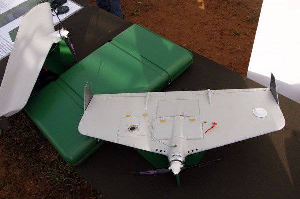
At the appointed hour, the UAV will still fly up and begin to “pump” information of interest to the intelligence chief. Naturally, this information will go to the computer company "Panasonic"!
That is, in order to receive information in the form of a graphic (photo and video) image of the underlying surface in real time, the head of intelligence has only one way out:
Put yourself on the control room of such a "Panasonic", taking it away from the commander of the reconnaissance patrol.
By the way, dear readers, you did not think about the question: in what form should the intelligence chief receive information from the reconnaissance patrol equipped with the technical reconnaissance equipment (UAV, radar stations, laser range finders)?
I believe that the following requirements can be applied to such information:
First: the information about the detected objects should contain their coordinates, preferably with shooting accuracy (plus or minus 25 meters).
Second: information about the object should contain the actual time of its detection.
Third: information about the object should clearly identify the detected object (tank, SAU, car, infantry group, etc.).
In addition, if the object moves, then it is highly desirable to have information about the direction (azimuth) and the speed of its movement.
Tactical UAVs, "coupled" with the ESA TZ, transmit to the flight control center information about the underlying surface in the video image format. This, as a rule, allows only a rough estimate of what the device “saw”. When you try to make a still image of the most “delicious” video fragments, they, as a rule, are blurred and do not allow you to perform the primary identification of the detected object with sufficient certainty. It is also quite difficult to obtain the shooting accuracy of the coordinates of the objects detected by the video image. With this method, errors can reach 150-500 meters (depending on the height and speed of flight of the UAV, as well as on the angles of roll and pitch).
These problems are due to the following factors:
1. Small flight altitude of UAVs used in tactical level.
2. Relatively high flight speed.
3. Low resolution of used video recording tools.
4. The lack of small-sized UAV systems of video stabilization.
5. Weak training and lack of experience among UAV operators (military servicemen with a term of 1 calling for a year).
At the same time, in most tactical UAV systems, high-quality photographic images of the underlying surface (that is, information that meets all of the above requirements) can be obtained only by reading data from a storage device (flash card) after the UAV has returned from flight.
In principle, problems with the use of video are solvable. The ways of their solution are obvious and we will not dwell on them.
We will focus on further processing and passing the information received.
So, a photographic image of an enemy object obtained by photographing, or using a freeze frame of a video image (assuming its high quality) can have the form shown in the photo below.
We see a rather distinctive outline of the trenches, communication lines, main and spare positions of fire weapons, which allow identifying the detected object as a platoon strong point of the second echelon of the company, prepared in engineering terms, but not occupied by a subdivision.
In order for this information to be adequately perceived by the chief of intelligence, an accurate attachment of the aerial photograph to the corresponding terrain on the electronic map is necessary.
This is relatively easy to do. You just need to know the exact coordinates of the angles of the aerial photograph and have the ability to orthotransform the image in the appropriate software.
For your information:
Orthotransformation (orthocorrection) is a mathematically rigorous transformation of the original image (snapshot) into orthogonal projection and elimination of distortions caused by the relief, shooting conditions, angle of shooting direction relative to the earth's surface (caused by the angles of pitch and roll of the aircraft) and camera type.
In the software of almost all UAV control systems there is such a possibility. That is, the snapshot, taking into account the direction and height of the flight, the pitch and roll angle, is attached and displayed on top of the electronic map without any serious problems.
It looks like this
It would seem that it only remains to display the obtained information with tactical signs like this:
... and transfer it to the subsystem of the commander and staff for evaluation and decision-making.
But no.
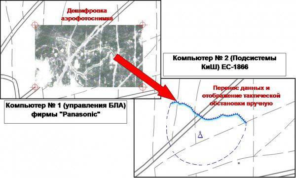
UAV control systems, as a rule, do not provide for the translation of the received photo and video information into tactical signs. And if they do, the formats for displaying tactical signs in their programs are not compatible with the formats for displaying these signs in the graphical user interface of the ESU TK. That is, even if we are on a computer that controls the flight of the UAV, if we display the situation on top of the orthotransformed photo image with tactical signs, then it will be impossible to transfer such an environment to the subsystem of the commander and headquarters.
In short. In order that the information on the screen of the chief of intelligence acquired the following form:
... in the subsystem of the commander and headquarters it is necessary to transfer the aerial photographs themselves ..!
However, in the data format adopted in the ESU TZ (which can be transferred from the UAV control system to the commander and headquarters subsystem with a snapshot), there is only one (!) Reference point (snapshot coordinates). This point is the geometric center of the aerial photograph.
That is, neither the large-scale parameters of the image itself, nor the direction of flight of the UAV (directional angle of the axis of the image), not to mention the angles of roll and pitch, are not taken into account in this format.
Naturally, having received information from the reconnaissance patrol only about the coordinates of the geometric center of the image, the chief of intelligence, when trying to display it on his electronic map, can interpret the position and scale of the image as desired:
Like this:
Or like this:
Or even like this:
In short - approximately enough, if not to say - at will.
And, if with point objects (which by chance were in the center of the “picture”), such “liberty” is still excusable, then in cases with objects that are located on the periphery of the picture, as well as with linear and area objects, the value of such information tends to ... Well, in general, you yourself know where.
In addition, the transfer to the intelligence chief of the reconnaissance patrol is not tactical signs, but photographs (files of which are ten times larger!), Seriously overload the communication channel used.
As an option: all the work on translating the information received from the BLAH into the tactical signs familiar to the general military commander is performed by the already familiar to us station lieutenant Petrov, having at the same time two PCs on his knees. Again - manually! From screen to screen.
Approximately like this:
At the same time, it is far from a fact that the usual commander of the reconnaissance platoon has sufficient qualifications to decipher the images.
I believe that the considerations expressed in this post will somewhat diminish the enthusiasm associated with the expectations imposed by a certain part of our generals on the prospects for using UAVs in the ESU TK system in the form in which it currently resides.
At the same time I will express the timid hope that these shortcomings will be critically interpreted by the developers of the ESU TK and UAV, and the conclusions drawn from them will be able to help improve the corresponding software providing the processing and transmission of information.
The closest boss to the soldier is the sergeant.
Part-commander.
This comrade moves across the battlefield either on foot or on an armored troop-carrier (BMP). This is his “personal transport”, the most powerful fire equipment, control center, communications center and software and hardware complex “in one bottle”.
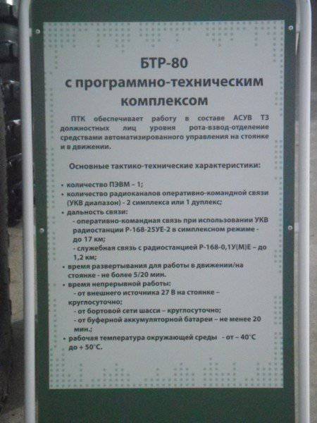
The linear BTR, in which, according to the plan of the creators of the ESU TZ, the squad leader should work, in appearance it is not much different from the usual BTR-80. Therefore, in this post, his photos will not be. Excuse me.
And what about this car inside?
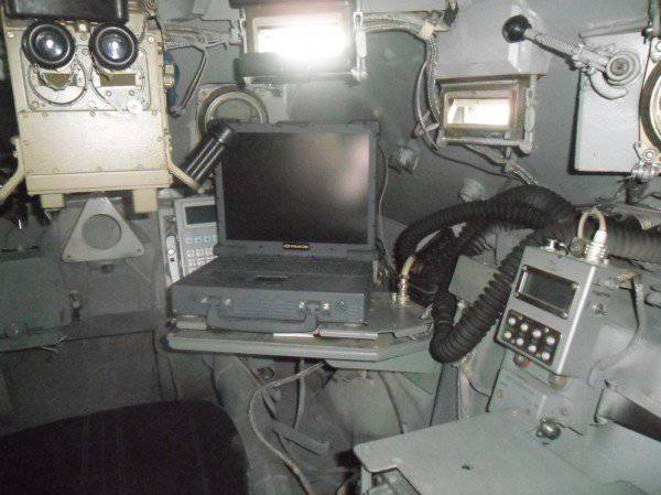
And the same as before: a protected computer by the Petersburg company RAMEK (Intel Core Duo LV processor - 1,66 GHz, with 512 MB RAM, 128 MB video card and 12,1 inches display. 40 hard disk, 80, or 120 GB)
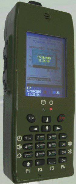
This computer is rigidly fixed in the body of the armored personnel carrier and cannot be used as a remote workplace. It is assumed that when leaving the car, the squad leader takes the subscriber communicator AK-3,5 (yes, the same one without the opportunity to see the card) and the portable radio station P-168-0,5 UM (0,1Y (M) E), which works if I don’t changes memory in the frequency range from 44 to 56 MHz.
Of the means of communication directly on the machine, there are two semi-sets of a portable VHF radio station P-168-25UE-2 (30-108 MHz, maximum communication distance up to 17 km).
To ensure communication within the BTR, a set of intercom and switching and control equipment (ASCA) was mounted, as well as a data transmission equipment (APS).
Yes! There is also a receiver that provides information about the geospatial position of the machine from the GLONASS network.
It's all.
At first glance - quite serious and modern car. For sergeant- "conscript" with a lifetime of 1 year.
But. We are with you, dear readers, not conscripts?
Let's face it.
The detachment commander will be OUTSIDE THE MACHINE in most cases during combat operations. Both in defense and in offensive. And with the movement of troops, as a rule, the radio silence mode is used and most of the stations operate only at reception. Moreover, for the level of the commander of the motorized rifle squad, this rule has no exceptions. Therefore, we will not consider options for organizing communications during the march.
And we consider the needs of the department in the transfer of information, for example, in the conduct of a defensive or offensive battle, and then compare them with the capabilities for providing radio channels that this combat vehicle can provide.
So.
The following information will circulate in the communication system of the automated control system during any type of combat operations:
1. Voice Yes, dear readers, nobody has canceled the command voice on the air.
2. Digital (batch) with graphic files of tactical situation and all sorts of text messages.
3. Digital (packet) with geospatial information about the position of objects that have means of GLONASS communication.
Now we will try to provide the commander (and his chiefs) of the department with all kinds of this information.
So.
Does voice two-way communication need a squad leader with his immediate superior (platoon commander)? Of course.
A similar connection with the crew of the BTR? Of course.
Even if such communication will be organized between the platoon commander, and all branch commanders and crews of armored personnel carriers on the same frequency. Only seven subscribers. We denote this case with red arrows with the number one. This is the first radio network. By the way, such an organization does not quite fit into the traditions of our motorized rifle troops, in which the control of armored cars in a platoon was always carried out by the deputy platoon commander. With its own separate radio network. But we will not trifle.
Go ahead. Send (and receive) target designation, combat orders and other information (in text and graphic form) should these officials? Should. Let it be the second radio network. Denote it by green arrows with the number two.
Will they transfer their geospatial coordinates to the squad leader and his BTR for displaying them on the map of the senior commander? How else would the senior commander find out where everyone is on the battlefield? In this case, the platoon leader can act as a repeater for such data, and only as a consumer. For example, if all vehicles and all squad leaders in a company (near 20 objects) are combined into such a radio network.
And here we cannot do without a separate radio network. We denote it by the blue arrows with the number 3.
The reader will ask: why not use one radio network to transmit all these types of information?
And because the speed of information exchange in the VHF radio networks is limited by the maximum 1,2 - 16 kbit / s. And if we use the radio network to control the battle, then you can really “drive” only one type of information on such a network.
Or "number."
Or "voice".
At the same time? Will not work! For the data transmission equipment is designed in such a way that if it has already put some digital information on the transmission, then at least we will lose your voice, but until the radio station broadcasts it, none of the subscribers of the radio network will hear you.
Besides. Practice has shown that for a more or less acceptable display on the electronic map of all moving objects, for example, a motorized rifle battalion (around 50 machines with regard to the amplification means), the position of each machine must be transmitted every XMUM once every minute. At the same time, to transmit such information on the VHF channel, it is necessary to allocate a separate frequency (radio network). Using one frequency at the same time to transmit both tactical and geospatial information will lead to the fact that the subscribers of this network will not receive either one within a reasonable time.
However, the radio equipment installed on this machine provides only TWO permanently operating radio channels.
Instead of the required (at least) three.
By the way, I’re not talking about how the radio communication will be provided with individual soldiers. Because if you include ordinary fighters in the voice radio network (even if on the rights of "listeners"), then the number of subscribers in such a network will exceed all reasonable limits.
Naturally, about any videoconferencing with an individual soldier at the junction of two fronts (about which the Bolsheviks were talking so long the dreams of our generals), no longer speak.
As part of the ESU TZ kit, the platoon commander and company commander must have a P-149MA3 commander vehicle based on the BTR-80, similar to the squad commander's car, which was described in the previous part.
But the battalion commander to manage his units has not one machine but three.
According to the state, in the communications battalion of the battalion, two P-149MA1 vehicles are located in the command and control sections of the commander and the chief of staff. (The same machines are envisaged for use as command and staff and in brigade management). The third battalion communication platoon machine, the P-149MA3, or the "linear" BTR, is the "property" of the commander of the communications platoon.
What is the battalion commander’s command and staff vehicle?
Let me remind you that in the Soviet, and in the Russian Army, the “infantry” and tank battalion commanders traditionally moved to the battlefield in command vehicles. The fundamental difference between the command post and the command vehicle is as follows:
The commander’s machine was, by and large, the usual “linear” armored personnel carrier (tank, infantry fighting vehicle), on which, in addition to standard weapons, additional means of communication were installed. This allowed the battalion commander, in addition to his personal participation in the battle (firing at the enemy), also to maintain contact with his superior, to interact with neighbors, and also to direct his subordinates - to give them orders (orders) and receive information from them. That is, the car was designed to perform two functions - combat and management.
Moreover, as is almost always the case when creating multifunctional systems, none of the functions could be performed on a “commander” machine with a sufficiently high quality. Its value in the performance of its managerial function was, as a rule, not very high, due to the congestion of the Zabronevian space with military means. In other words - with a map, a tablet and a commander's bag in such a machine it was just not to turn around. And the use of standard weapons was limited to the tactical requirement for the command and observation post of the battalion at some distance from the line of military contact.
In contrast to the "commander" machine, the command and staff vehicle (KSHM) is usually an armored vehicle, more suited to ensure the fulfillment of a management function. Armament on such a machine is installed either in the minimum required volume, or not installed at all. But the means of communication and information processing available on it, as a rule, provide the commander with a fairly wide range of management capabilities.
That is, when deciding on the "replanting" of the battalion commander on the KSHM, the emphasis was clearly shifted towards the battalion commander performing the control functions. And although this is an absolutely correct tendency, nevertheless, the complete deprivation of the commander of his own combat vehicle (as is now envisaged by the 5 ombsr equipped with the ESU TK) raises some doubts.
I recall that in the US Army, for example, until recently, the commander of the line battalion also had at his disposal only a commander tank or a BMP.
But the increased need to perform exactly the managerial function and the impossibility of their fulfillment by the commander in the close space of a commander tank (BMP) forced the US army to change the existing order of things.
However, the Americans did not completely deprive the battalion commander of a “personal” combat unit and went a little different way.
At present, the commander of a mixed mechanized battalion (two tank and two motorized infantry companies) of the "heavy" mechanized brigade of the mechanized division of the United States has in his personal possession two vehicles:
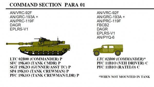
As we can see, the necessary means of communication and information processing, including the FBCB2 system terminal, are mounted in the car HMMWV, which is essentially a staff vehicle.
That is, the combat function and the control function (combat planning) of our “probable friends” are clearly separated “by machine”.
The creators of the promising states of our heavy brigade decided to follow a similar path. The battalion communication platoon staff is supposed to be changed by increasing the number of vehicles in it from three to five. Of these, two commanding infantry combat vehicles, or armored personnel carriers (for the battalion commander and deputy battalion commander), and three command and staff vehicles (Р-149БМРГ, or Р-149МА1).
What can the P-149MA machine “know how”?
Firstly, as an AWP, it uses EC-1866 computers, which by their parameters are similar to the Ramek PC installed on “linear” armored personnel carriers. For what purpose PCs of different manufacturers, similar in their parameters, are used in the system - for me personally it remains a mystery.
Data PC can be used "to take away". Why it was impossible to provide the same function on linear armored vehicles is also not very clear.
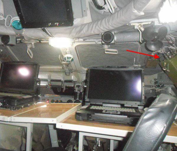
In addition, the kit of the machine also, as well as the P-149MA3, includes a communicator with which it is supposed to be built using Wi-Fi technology. True, you cannot go far from the communicator car. According to the developers, a steady signal can be caught at a distance of no more than 150-200 meters. The block for data transmission using Wi-Fi technology is shown in the previous photo by a red arrow.
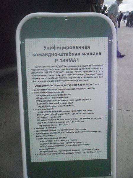
This is a poster that stood side by side. Only here it is written on it about the car, not all. Apparently the creators were ashamed. In addition to the HF and VHF radio stations, this facility is also installed on this site:
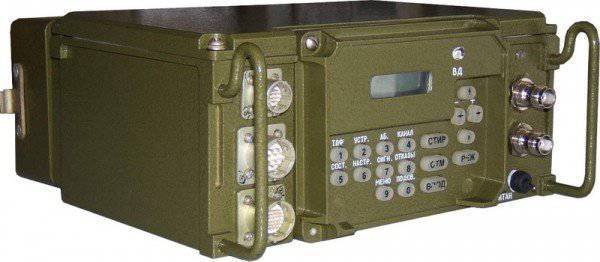
The radio station is called P-168МРАЕ
TTH devices can be viewed on the official website of the concern "Constellation" here: http://www.sozvezdie.su/catalog/r168mrae/
Of all the variety of device characteristics listed there, we are concerned primarily with three:
1. Frequency range - 1,5-1,75 GHz
2. The speed of transmission and reception of data in digital format:
- over the C1-FL interface with speeds 1, 2; 2,4; 4,8; 9,6; 16 kbps;
- via RS-232C, RS-485 connections with a maximum speed of 115 kbit / s;
- via Ethernet interface with a maximum speed of 10 Mbps;
3. Claimed communication distance:
- when using the antenna AB in the parking lot and in motion - at least 6 km,
- when using the antenna of the KR in the parking lot - not less than 9 km,
- when using an MPA directional antenna in the parking lot - at least 20 km
However, this station is considered by developers as the main means of transmitting digital information in the platoon-battalion-brigade link, they somehow very modestly kept silent about its capabilities for REAL, rather than the declared communication range on REAL terrain, which will carry out their tasks troops. And which, based on Russian conditions, will have little in common with an absolutely smooth surface.
The fact is that the use of the 1,5-1,75 GHz frequency band entails, in addition to a sharp increase in the speed of information transmission, also some, let's say, features of the use of such stations.
1 GHz is known to be 1000 MHz, or 1 000 000 KHz, or 1 000 000 000 Hz or 109, (or 10 to the ninth power) Hertz.
The 1,5 GHz band lies just to the right of the range used in conventional microwave ovens. And, in contrast to the VHF range, it has extremely weak capabilities when spreading on rough terrain. Any grove of trees, bushes, terrain, buildings and even wooden fences around them will create an insurmountable obstacle for radio waves of this range.
Consequently, in real (and not virtual) space, the communication range in this range will be limited to the line of sight.
And in the most direct sense of the word “visibility”, without any equivocation, such as “radio visibility”, or “radar visibility”.
Yes, at these stations, in principle, it will be possible to implement “MESH” technology of self-organizing mobile networks.
But the military concept of "guaranteed data transmission from mobile sites using broadband radio stations" is somewhat different from the understanding of the same concept by civilian specialists.
While you can only guarantee one thing:
Any NORMAL fighter will search on the battlefield for the COVER and at the same time disguise himself and disguise his car in all possible ways.
I will express a seditious assumption that the location of the battalion’s armored facilities, for example, who occupied the defense in mid-terrain, will correspond little to the ideal conditions for ensuring radio communication between them using the microwave range.
On the intelligence and combat guard units that will at the same time carry out their tasks at a distance of 10-15 and 2 km (respectively), I will wisely keep silence. I am silent and the possibilities for data transmission in such networks when conducting combat in urban environments.
Unfortunately, the level of professionalism of the developers of technical assignments, as well as of military-scientific personnel engaged in scientific support of projects like the ESU TK, remains, to put it mildly, insufficient. This conclusion can be made from the analysis of existing TZ and IPF, and from the fact that there are no such documents for the development of a number of settlement and information tasks.
I will reveal a little military secret.
Often, in order to meet the deadlines set by the technical assignment, the specialists of the “Constellation” concern - civilians - are forced to develop the operational task setting for the implementation of the system functions specified in the TOR.
In other words, civilian manufacturers make a system for military customers, guided not by the needs of the army, but on the basis of their own (!) Ideas, how and what tasks this system should solve on the battlefield.
But the reasons for the current situation and the way out of it are the subject of a separate large article.
7. Findings.
What is called the points.
By and large, any automated control system that has non-stationary, and most importantly - spatially distributed organs and control objects consists of four main components:
1. Machine software (information processing hardware).
The developers' refusal of the outdated “Baguette” PCs, which previously formed the basis of the ESU TZ hardware in favor of more modern EC-1866 PCs, is justified and correct. Despite the fact that the latter have imported components in the element base. However, the issue of certification (special tests and special tests) of these machines, as well as other hardware in the system, nevertheless should be taken care of.
In our opinion, the rejection of the server-oriented architecture of a local computer network is a very serious mistake.
2. Software and databases (software and information processing tools).
The level of compliance of the software complex in its current form with the real needs of the troops and headquarters - I suppose the main part of the article says enough.
3. Devices and channels (systems) of communication (means of information transfer).
Relying on a communication system based on unreliable elements that tend to fail even in relatively normal operating conditions is quite risky. 17 “base” stations that provide a single information field in the brigade's area of responsibility, prior to the start of the exercise and during it, 4 failed. And this is not in 50-degree heat and not in the Siberian frosts, not under the influence of the enemy, but in a normal autumn near Moscow. Means of the brigade failed to "bring back to life" none. Means of concern "Constellation" was restored one unit.
4. Trained staff (people using the first three components as a tool for solving managerial tasks).
The officer corps is the most valuable resource of any army in the world.
In the future, when conducting and covering such exercises in the media, one important circumstance should be borne in mind. Our army is already so small that most officers already know each other by sight.
And it was simply impossible to find out the military personnel from the 732 Center for the combat use of ACCS of the Ground Forces, who work during the exercise in the staff vehicles at the staff positions of the 5 bsbc officials.
“Disguised command post destroyed! Sorry, comrade general! ”
At the appointed hour, the UAV will still fly up and begin to “pump” information of interest to the intelligence chief. Naturally, this information will go to the computer company "Panasonic"!
That is, in order to receive information in the form of a graphic (photo and video) image of the underlying surface in real time, the head of intelligence has only one way out:
Put yourself on the control room of such a "Panasonic", taking it away from the commander of the reconnaissance patrol.
By the way, dear readers, you did not think about the question: in what form should the intelligence chief receive information from the reconnaissance patrol equipped with the technical reconnaissance equipment (UAV, radar stations, laser range finders)?
I believe that the following requirements can be applied to such information:
First: the information about the detected objects should contain their coordinates, preferably with shooting accuracy (plus or minus 25 meters).
Second: information about the object should contain the actual time of its detection.
Third: information about the object should clearly identify the detected object (tank, SAU, car, infantry group, etc.).
In addition, if the object moves, then it is highly desirable to have information about the direction (azimuth) and the speed of its movement.
Tactical UAVs, "coupled" with the ESA TZ, transmit to the flight control center information about the underlying surface in the video image format. This, as a rule, allows only a rough estimate of what the device “saw”. When you try to make a still image of the most “delicious” video fragments, they, as a rule, are blurred and do not allow you to perform the primary identification of the detected object with sufficient certainty. It is also quite difficult to obtain the shooting accuracy of the coordinates of the objects detected by the video image. With this method, errors can reach 150-500 meters (depending on the height and speed of flight of the UAV, as well as on the angles of roll and pitch).
These problems are due to the following factors:
1. Small flight altitude of UAVs used in tactical level.
2. Relatively high flight speed.
3. Low resolution of used video recording tools.
4. The lack of small-sized UAV systems of video stabilization.
5. Weak training and lack of experience among UAV operators (military servicemen with a term of 1 calling for a year).
At the same time, in most tactical UAV systems, high-quality photographic images of the underlying surface (that is, information that meets all of the above requirements) can be obtained only by reading data from a storage device (flash card) after the UAV has returned from flight.
In principle, problems with the use of video are solvable. The ways of their solution are obvious and we will not dwell on them.
We will focus on further processing and passing the information received.
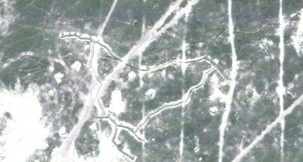
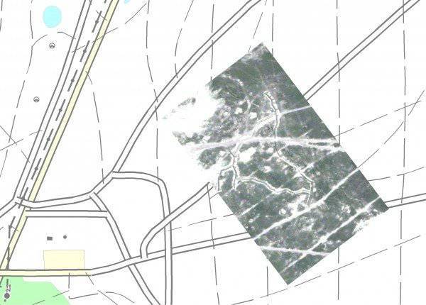
So, a photographic image of an enemy object obtained by photographing, or using a freeze frame of a video image (assuming its high quality) can have the form shown in the photo below.
We see a rather distinctive outline of the trenches, communication lines, main and spare positions of fire weapons, which allow identifying the detected object as a platoon strong point of the second echelon of the company, prepared in engineering terms, but not occupied by a subdivision.
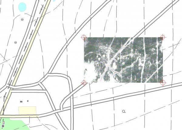
In order for this information to be adequately perceived by the chief of intelligence, an accurate attachment of the aerial photograph to the corresponding terrain on the electronic map is necessary.
This is relatively easy to do. You just need to know the exact coordinates of the angles of the aerial photograph and have the ability to orthotransform the image in the appropriate software.
For your information:
Orthotransformation (orthocorrection) is a mathematically rigorous transformation of the original image (snapshot) into orthogonal projection and elimination of distortions caused by the relief, shooting conditions, angle of shooting direction relative to the earth's surface (caused by the angles of pitch and roll of the aircraft) and camera type.
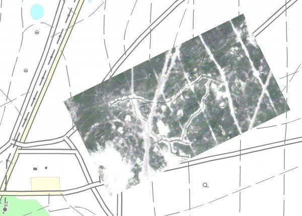
In the software of almost all UAV control systems there is such a possibility. That is, the snapshot, taking into account the direction and height of the flight, the pitch and roll angle, is attached and displayed on top of the electronic map without any serious problems.
It looks like this
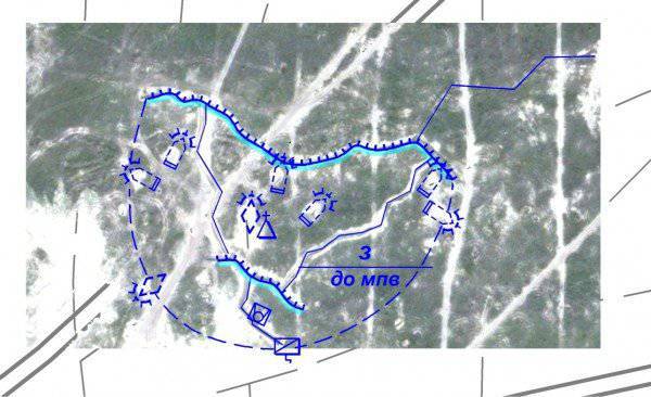
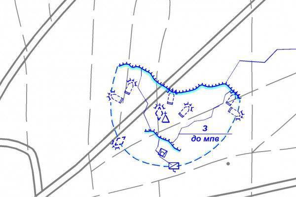
It would seem that it only remains to display the obtained information with tactical signs like this:
... and transfer it to the subsystem of the commander and staff for evaluation and decision-making.
But no.
UAV control systems, as a rule, do not provide for the translation of the received photo and video information into tactical signs. And if they do, the formats for displaying tactical signs in their programs are not compatible with the formats for displaying these signs in the graphical user interface of the ESU TK. That is, even if we are on a computer that controls the flight of the UAV, if we display the situation on top of the orthotransformed photo image with tactical signs, then it will be impossible to transfer such an environment to the subsystem of the commander and headquarters.
In short. In order that the information on the screen of the chief of intelligence acquired the following form:
... in the subsystem of the commander and headquarters it is necessary to transfer the aerial photographs themselves ..!
However, in the data format adopted in the ESU TZ (which can be transferred from the UAV control system to the commander and headquarters subsystem with a snapshot), there is only one (!) Reference point (snapshot coordinates). This point is the geometric center of the aerial photograph.
That is, neither the large-scale parameters of the image itself, nor the direction of flight of the UAV (directional angle of the axis of the image), not to mention the angles of roll and pitch, are not taken into account in this format.
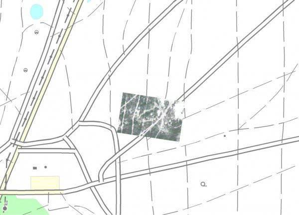
Naturally, having received information from the reconnaissance patrol only about the coordinates of the geometric center of the image, the chief of intelligence, when trying to display it on his electronic map, can interpret the position and scale of the image as desired:
Like this:
Or like this:
Or even like this:
In short - approximately enough, if not to say - at will.
And, if with point objects (which by chance were in the center of the “picture”), such “liberty” is still excusable, then in cases with objects that are located on the periphery of the picture, as well as with linear and area objects, the value of such information tends to ... Well, in general, you yourself know where.
In addition, the transfer to the intelligence chief of the reconnaissance patrol is not tactical signs, but photographs (files of which are ten times larger!), Seriously overload the communication channel used.
As an option: all the work on translating the information received from the BLAH into the tactical signs familiar to the general military commander is performed by the already familiar to us station lieutenant Petrov, having at the same time two PCs on his knees. Again - manually! From screen to screen.
Approximately like this:
At the same time, it is far from a fact that the usual commander of the reconnaissance platoon has sufficient qualifications to decipher the images.
I believe that the considerations expressed in this post will somewhat diminish the enthusiasm associated with the expectations imposed by a certain part of our generals on the prospects for using UAVs in the ESU TK system in the form in which it currently resides.
At the same time I will express the timid hope that these shortcomings will be critically interpreted by the developers of the ESU TK and UAV, and the conclusions drawn from them will be able to help improve the corresponding software providing the processing and transmission of information.
The closest boss to the soldier is the sergeant.
Part-commander.
This comrade moves across the battlefield either on foot or on an armored troop-carrier (BMP). This is his “personal transport”, the most powerful fire equipment, control center, communications center and software and hardware complex “in one bottle”.
The linear BTR, in which, according to the plan of the creators of the ESU TZ, the squad leader should work, in appearance it is not much different from the usual BTR-80. Therefore, in this post, his photos will not be. Excuse me.
And what about this car inside?
And the same as before: a protected computer by the Petersburg company RAMEK (Intel Core Duo LV processor - 1,66 GHz, with 512 MB RAM, 128 MB video card and 12,1 inches display. 40 hard disk, 80, or 120 GB)
This computer is rigidly fixed in the body of the armored personnel carrier and cannot be used as a remote workplace. It is assumed that when leaving the car, the squad leader takes the subscriber communicator AK-3,5 (yes, the same one without the opportunity to see the card) and the portable radio station P-168-0,5 UM (0,1Y (M) E), which works if I don’t changes memory in the frequency range from 44 to 56 MHz.
Of the means of communication directly on the machine, there are two semi-sets of a portable VHF radio station P-168-25UE-2 (30-108 MHz, maximum communication distance up to 17 km).
To ensure communication within the BTR, a set of intercom and switching and control equipment (ASCA) was mounted, as well as a data transmission equipment (APS).
Yes! There is also a receiver that provides information about the geospatial position of the machine from the GLONASS network.
It's all.
At first glance - quite serious and modern car. For sergeant- "conscript" with a lifetime of 1 year.
But. We are with you, dear readers, not conscripts?
Let's face it.
The detachment commander will be OUTSIDE THE MACHINE in most cases during combat operations. Both in defense and in offensive. And with the movement of troops, as a rule, the radio silence mode is used and most of the stations operate only at reception. Moreover, for the level of the commander of the motorized rifle squad, this rule has no exceptions. Therefore, we will not consider options for organizing communications during the march.
And we consider the needs of the department in the transfer of information, for example, in the conduct of a defensive or offensive battle, and then compare them with the capabilities for providing radio channels that this combat vehicle can provide.
So.
The following information will circulate in the communication system of the automated control system during any type of combat operations:
1. Voice Yes, dear readers, nobody has canceled the command voice on the air.
2. Digital (batch) with graphic files of tactical situation and all sorts of text messages.
3. Digital (packet) with geospatial information about the position of objects that have means of GLONASS communication.
Now we will try to provide the commander (and his chiefs) of the department with all kinds of this information.
So.
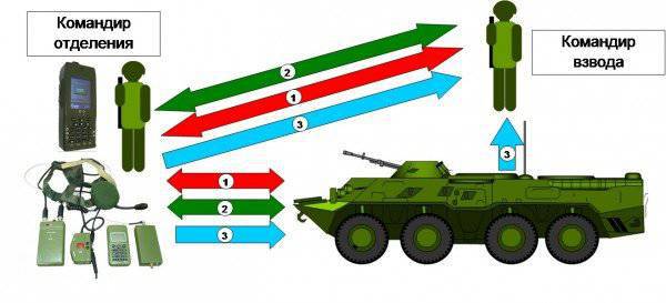
Does voice two-way communication need a squad leader with his immediate superior (platoon commander)? Of course.
A similar connection with the crew of the BTR? Of course.
Even if such communication will be organized between the platoon commander, and all branch commanders and crews of armored personnel carriers on the same frequency. Only seven subscribers. We denote this case with red arrows with the number one. This is the first radio network. By the way, such an organization does not quite fit into the traditions of our motorized rifle troops, in which the control of armored cars in a platoon was always carried out by the deputy platoon commander. With its own separate radio network. But we will not trifle.
Go ahead. Send (and receive) target designation, combat orders and other information (in text and graphic form) should these officials? Should. Let it be the second radio network. Denote it by green arrows with the number two.
Will they transfer their geospatial coordinates to the squad leader and his BTR for displaying them on the map of the senior commander? How else would the senior commander find out where everyone is on the battlefield? In this case, the platoon leader can act as a repeater for such data, and only as a consumer. For example, if all vehicles and all squad leaders in a company (near 20 objects) are combined into such a radio network.
And here we cannot do without a separate radio network. We denote it by the blue arrows with the number 3.
The reader will ask: why not use one radio network to transmit all these types of information?
And because the speed of information exchange in the VHF radio networks is limited by the maximum 1,2 - 16 kbit / s. And if we use the radio network to control the battle, then you can really “drive” only one type of information on such a network.
Or "number."
Or "voice".
At the same time? Will not work! For the data transmission equipment is designed in such a way that if it has already put some digital information on the transmission, then at least we will lose your voice, but until the radio station broadcasts it, none of the subscribers of the radio network will hear you.
Besides. Practice has shown that for a more or less acceptable display on the electronic map of all moving objects, for example, a motorized rifle battalion (around 50 machines with regard to the amplification means), the position of each machine must be transmitted every XMUM once every minute. At the same time, to transmit such information on the VHF channel, it is necessary to allocate a separate frequency (radio network). Using one frequency at the same time to transmit both tactical and geospatial information will lead to the fact that the subscribers of this network will not receive either one within a reasonable time.
However, the radio equipment installed on this machine provides only TWO permanently operating radio channels.
Instead of the required (at least) three.
By the way, I’re not talking about how the radio communication will be provided with individual soldiers. Because if you include ordinary fighters in the voice radio network (even if on the rights of "listeners"), then the number of subscribers in such a network will exceed all reasonable limits.
Naturally, about any videoconferencing with an individual soldier at the junction of two fronts (about which the Bolsheviks were talking so long the dreams of our generals), no longer speak.
As part of the ESU TZ kit, the platoon commander and company commander must have a P-149MA3 commander vehicle based on the BTR-80, similar to the squad commander's car, which was described in the previous part.
But the battalion commander to manage his units has not one machine but three.
According to the state, in the communications battalion of the battalion, two P-149MA1 vehicles are located in the command and control sections of the commander and the chief of staff. (The same machines are envisaged for use as command and staff and in brigade management). The third battalion communication platoon machine, the P-149MA3, or the "linear" BTR, is the "property" of the commander of the communications platoon.
What is the battalion commander’s command and staff vehicle?
Let me remind you that in the Soviet, and in the Russian Army, the “infantry” and tank battalion commanders traditionally moved to the battlefield in command vehicles. The fundamental difference between the command post and the command vehicle is as follows:
The commander’s machine was, by and large, the usual “linear” armored personnel carrier (tank, infantry fighting vehicle), on which, in addition to standard weapons, additional means of communication were installed. This allowed the battalion commander, in addition to his personal participation in the battle (firing at the enemy), also to maintain contact with his superior, to interact with neighbors, and also to direct his subordinates - to give them orders (orders) and receive information from them. That is, the car was designed to perform two functions - combat and management.
Moreover, as is almost always the case when creating multifunctional systems, none of the functions could be performed on a “commander” machine with a sufficiently high quality. Its value in the performance of its managerial function was, as a rule, not very high, due to the congestion of the Zabronevian space with military means. In other words - with a map, a tablet and a commander's bag in such a machine it was just not to turn around. And the use of standard weapons was limited to the tactical requirement for the command and observation post of the battalion at some distance from the line of military contact.
In contrast to the "commander" machine, the command and staff vehicle (KSHM) is usually an armored vehicle, more suited to ensure the fulfillment of a management function. Armament on such a machine is installed either in the minimum required volume, or not installed at all. But the means of communication and information processing available on it, as a rule, provide the commander with a fairly wide range of management capabilities.
That is, when deciding on the "replanting" of the battalion commander on the KSHM, the emphasis was clearly shifted towards the battalion commander performing the control functions. And although this is an absolutely correct tendency, nevertheless, the complete deprivation of the commander of his own combat vehicle (as is now envisaged by the 5 ombsr equipped with the ESU TK) raises some doubts.
I recall that in the US Army, for example, until recently, the commander of the line battalion also had at his disposal only a commander tank or a BMP.
But the increased need to perform exactly the managerial function and the impossibility of their fulfillment by the commander in the close space of a commander tank (BMP) forced the US army to change the existing order of things.
However, the Americans did not completely deprive the battalion commander of a “personal” combat unit and went a little different way.
At present, the commander of a mixed mechanized battalion (two tank and two motorized infantry companies) of the "heavy" mechanized brigade of the mechanized division of the United States has in his personal possession two vehicles:
As we can see, the necessary means of communication and information processing, including the FBCB2 system terminal, are mounted in the car HMMWV, which is essentially a staff vehicle.
That is, the combat function and the control function (combat planning) of our “probable friends” are clearly separated “by machine”.
The creators of the promising states of our heavy brigade decided to follow a similar path. The battalion communication platoon staff is supposed to be changed by increasing the number of vehicles in it from three to five. Of these, two commanding infantry combat vehicles, or armored personnel carriers (for the battalion commander and deputy battalion commander), and three command and staff vehicles (Р-149БМРГ, or Р-149МА1).
What can the P-149MA machine “know how”?
Firstly, as an AWP, it uses EC-1866 computers, which by their parameters are similar to the Ramek PC installed on “linear” armored personnel carriers. For what purpose PCs of different manufacturers, similar in their parameters, are used in the system - for me personally it remains a mystery.
Data PC can be used "to take away". Why it was impossible to provide the same function on linear armored vehicles is also not very clear.
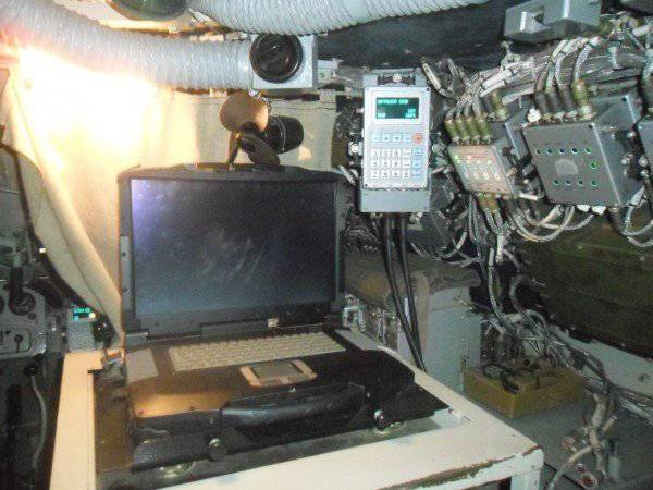
In addition, the kit of the machine also, as well as the P-149MA3, includes a communicator with which it is supposed to be built using Wi-Fi technology. True, you cannot go far from the communicator car. According to the developers, a steady signal can be caught at a distance of no more than 150-200 meters. The block for data transmission using Wi-Fi technology is shown in the previous photo by a red arrow.
This is a poster that stood side by side. Only here it is written on it about the car, not all. Apparently the creators were ashamed. In addition to the HF and VHF radio stations, this facility is also installed on this site:
The radio station is called P-168МРАЕ
TTH devices can be viewed on the official website of the concern "Constellation" here: http://www.sozvezdie.su/catalog/r168mrae/
Of all the variety of device characteristics listed there, we are concerned primarily with three:
1. Frequency range - 1,5-1,75 GHz
2. The speed of transmission and reception of data in digital format:
- over the C1-FL interface with speeds 1, 2; 2,4; 4,8; 9,6; 16 kbps;
- via RS-232C, RS-485 connections with a maximum speed of 115 kbit / s;
- via Ethernet interface with a maximum speed of 10 Mbps;
3. Claimed communication distance:
- when using the antenna AB in the parking lot and in motion - at least 6 km,
- when using the antenna of the KR in the parking lot - not less than 9 km,
- when using an MPA directional antenna in the parking lot - at least 20 km
However, this station is considered by developers as the main means of transmitting digital information in the platoon-battalion-brigade link, they somehow very modestly kept silent about its capabilities for REAL, rather than the declared communication range on REAL terrain, which will carry out their tasks troops. And which, based on Russian conditions, will have little in common with an absolutely smooth surface.
The fact is that the use of the 1,5-1,75 GHz frequency band entails, in addition to a sharp increase in the speed of information transmission, also some, let's say, features of the use of such stations.
1 GHz is known to be 1000 MHz, or 1 000 000 KHz, or 1 000 000 000 Hz or 109, (or 10 to the ninth power) Hertz.
The 1,5 GHz band lies just to the right of the range used in conventional microwave ovens. And, in contrast to the VHF range, it has extremely weak capabilities when spreading on rough terrain. Any grove of trees, bushes, terrain, buildings and even wooden fences around them will create an insurmountable obstacle for radio waves of this range.
Consequently, in real (and not virtual) space, the communication range in this range will be limited to the line of sight.
And in the most direct sense of the word “visibility”, without any equivocation, such as “radio visibility”, or “radar visibility”.
Yes, at these stations, in principle, it will be possible to implement “MESH” technology of self-organizing mobile networks.
But the military concept of "guaranteed data transmission from mobile sites using broadband radio stations" is somewhat different from the understanding of the same concept by civilian specialists.
While you can only guarantee one thing:
Any NORMAL fighter will search on the battlefield for the COVER and at the same time disguise himself and disguise his car in all possible ways.
I will express a seditious assumption that the location of the battalion’s armored facilities, for example, who occupied the defense in mid-terrain, will correspond little to the ideal conditions for ensuring radio communication between them using the microwave range.
On the intelligence and combat guard units that will at the same time carry out their tasks at a distance of 10-15 and 2 km (respectively), I will wisely keep silence. I am silent and the possibilities for data transmission in such networks when conducting combat in urban environments.
Unfortunately, the level of professionalism of the developers of technical assignments, as well as of military-scientific personnel engaged in scientific support of projects like the ESU TK, remains, to put it mildly, insufficient. This conclusion can be made from the analysis of existing TZ and IPF, and from the fact that there are no such documents for the development of a number of settlement and information tasks.
I will reveal a little military secret.
Often, in order to meet the deadlines set by the technical assignment, the specialists of the “Constellation” concern - civilians - are forced to develop the operational task setting for the implementation of the system functions specified in the TOR.
In other words, civilian manufacturers make a system for military customers, guided not by the needs of the army, but on the basis of their own (!) Ideas, how and what tasks this system should solve on the battlefield.
But the reasons for the current situation and the way out of it are the subject of a separate large article.
7. Findings.
What is called the points.
By and large, any automated control system that has non-stationary, and most importantly - spatially distributed organs and control objects consists of four main components:
1. Machine software (information processing hardware).
The developers' refusal of the outdated “Baguette” PCs, which previously formed the basis of the ESU TZ hardware in favor of more modern EC-1866 PCs, is justified and correct. Despite the fact that the latter have imported components in the element base. However, the issue of certification (special tests and special tests) of these machines, as well as other hardware in the system, nevertheless should be taken care of.
In our opinion, the rejection of the server-oriented architecture of a local computer network is a very serious mistake.
2. Software and databases (software and information processing tools).
The level of compliance of the software complex in its current form with the real needs of the troops and headquarters - I suppose the main part of the article says enough.
3. Devices and channels (systems) of communication (means of information transfer).
Relying on a communication system based on unreliable elements that tend to fail even in relatively normal operating conditions is quite risky. 17 “base” stations that provide a single information field in the brigade's area of responsibility, prior to the start of the exercise and during it, 4 failed. And this is not in 50-degree heat and not in the Siberian frosts, not under the influence of the enemy, but in a normal autumn near Moscow. Means of the brigade failed to "bring back to life" none. Means of concern "Constellation" was restored one unit.
4. Trained staff (people using the first three components as a tool for solving managerial tasks).
The officer corps is the most valuable resource of any army in the world.
In the future, when conducting and covering such exercises in the media, one important circumstance should be borne in mind. Our army is already so small that most officers already know each other by sight.
And it was simply impossible to find out the military personnel from the 732 Center for the combat use of ACCS of the Ground Forces, who work during the exercise in the staff vehicles at the staff positions of the 5 bsbc officials.
“Disguised command post destroyed! Sorry, comrade general! ”
Information