SBIRS satellite warning system (USA)

SBIRS-GEO satellite in orbit
The Pentagon has a developed and numerous space constellation, and a special place in it is occupied by missile attack warning satellites. The task of detecting launches and reconnaissance is now assigned to vehicles and devices of the SBIRS family. This year, the deployment of such a "constellation" was completed, but all construction plans could not be completed.
course for renewal
The space echelon of the American early warning system has existed since the sixties and has been repeatedly updated since then. The next stage of modernization was launched in the early nineties following the results of the Gulf War. By 1994, the Pentagon had formulated its requirements and desires, after which the development of a promising project began.
According to the terms of reference, the new early warning satellite system was supposed to retain the main capabilities of the existing constellation and receive new functions. She was required not only to detect launches of space or strategic ballistic missiles, but also to identify the activities of operational-tactical complexes. In addition, the satellite was supposed to conduct reconnaissance over the theater of operations.
The program for the development of new spacecraft was called SBIRS (Space-Based Infrared System - “Space-Based Infrared System”). Several organizations with extensive experience in the creation of space technology participated in the competitive stage. As a result, Lockheed Martin and Northrop Grumman received contracts for the production of various equipment for SBIRS.
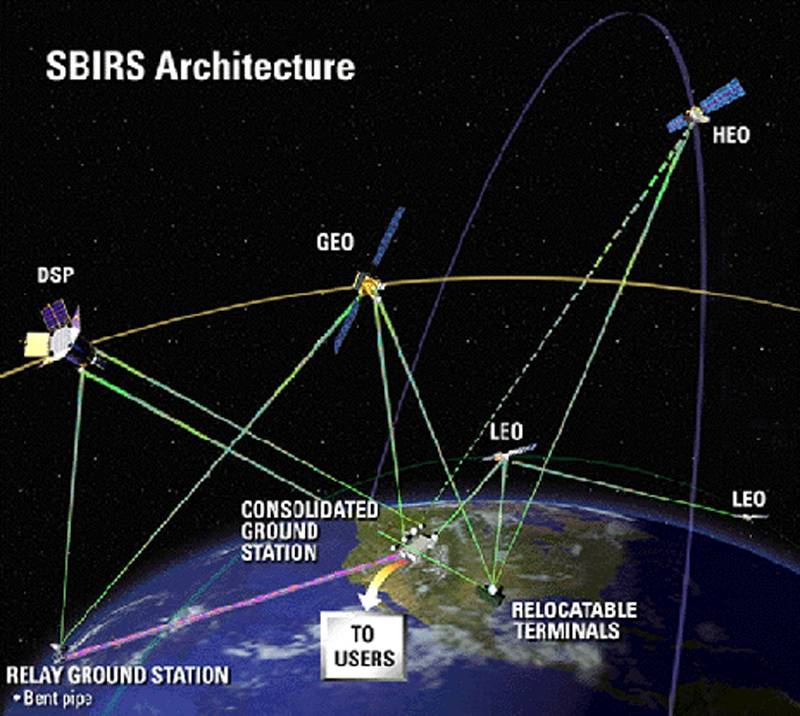
The principle of operation of the SBIRS system in the initial configuration with three components
Due to the increased requirements for the new satellite system, the development was significantly delayed. It was originally planned that the first SBIRS satellites would go into space at the beginning of the XNUMXs, but these plans were not fulfilled. In the future, the timing of the start of deployment was repeatedly shifted, and the cost of the program was constantly growing. The Pentagon and contractors could not keep within the established limits, which caused criticism from legislators and threatened the development of the project.
Contracts for the manufacture of the first satellites and new types of instruments were signed at the beginning of the 2011s, but the construction of these products was delayed - as was the project as a whole. Because of this, the first apparatus of the SBIRS series was sent into orbit only in XNUMX. In addition, by this time the overall architecture of the “constellation” had been revised and the project had been reduced, both for economy and in order to obtain additional benefits.
Changes and cuts
The original version of the SBIRS project proposed the creation of a three-component early warning system. So, satellites with the working designation SBIRS Low or SBIRS-LEO should have been placed in low Earth orbits. In geostationary orbits, they were going to operate specially designed SBIRS High vehicles (aka SBIRS-GEO). It also provided for the installation of individual reconnaissance modules on satellites of other types operating in a highly elliptical orbit. Such devices were called SBIRS-HEO. It was planned to manage the "constellation" from two ground cents in the United States.
Due to the complexity of the tasks and excessive development costs in 2001, the program was divided. The low-orbit component of SBIRS-LEO was separated into a separate project and transferred to the Missile Defense Agency. There he was given the new name Space Tracking and Surveillance System (STSS). This project was completed and two STSS satellites were sent into orbit in September 2009. They worked and collected data for the next 12 years. In March 2022, the operation of the STSS ended.
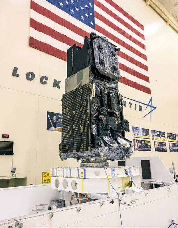
Satellite SBIRS-GEO-5 in the assembly shop
At the same time, work on the SBIRS program continued. At the beginning of the XNUMXs, contracts appeared for the manufacture and launch of up to three SBIRS-GEO satellites and a pair of SBIRS-HEO modules for mounting on other vehicles. The development of the modules did not encounter major problems and was completed without significant deviation from the schedule.
The fate of the SBIRS-GEO satellites turned out to be more difficult. Due to technical difficulties and high requirements, their development was delayed and did not meet the assigned budget. In the middle of the decade, Congress even demanded a revision and reduction of the program in order to avoid unnecessary spending.
Nevertheless, by the end of the 2014s, the main problems were resolved, and the Pentagon issued new orders to contractors for the assembly of serial satellites and equipment modules. The last contract of this kind was signed in XNUMX, it provided for the launch of the fifth and sixth SBIRS satellites.
Grouping creation
The SBIRS-HEO reconnaissance equipment module was the first to reach the deployment stage. The first product of this type went into orbit on June 28, 2006 from the Vandenberg base as part of the payload of the USA-184 satellite. In March 2008, the SBIRS-HEO-200 module flew on the USA-2 satellite. Two more sets of instruments were launched into orbit in 2014 and 2017. According to known data, all SBIRS-HEOs remain in orbit and are used to collect information.
On May 7, 2011, a launch vehicle with the first SBIRS-GEO satellite, designated USA-230, was launched from Cape Canaveral Air Force Base. The second device, SBIRS-GEO-2 or USA-241, was launched almost two years later. The third satellite began work in the first months of 2017, and a year later the fourth one joined the constellation.
SBIRS-GEO-6 - the latest in a series
In the middle of the last decade, plans to build the fifth and sixth SBIRS-GEO satellites were seriously criticized, but the program's supporters managed to defend them. On May 18, 2021, the SBIRS-GEO-5 product was launched, and on August 4, 2022, the sixth satellite flew.
They refused to continue the construction of the SBIRS group. In 2018, a decision was made to develop a fundamentally new series of early warning spacecraft called Next-Generation Overhead Persistent Infrared (NG-OPIR). They must use a modern component base and have higher performance, incl. economic. The development of a new satellite is coming to an end, and launches of finished products will begin in the coming years.
Technical features
The SBIRS-GEO satellite was developed by Lockheed Martin with the participation of several subcontractors. This is a large and heavy spacecraft designed for long-term operation in geostationary orbit and monitoring the territory of a potential enemy or other specified areas.
The device is based on the A2100 / LM2100 platform. It is built in a rectangular hull and equipped with foldable solar panels. In the working configuration, the span of the panels reaches 15 m with a product height of more than 6,5 m. The mass of the satellite is more than 2,5 tons. There is a propulsion system on board for maneuvering with a fuel reserve of almost 200 kg. The payload reaches 500 kg.
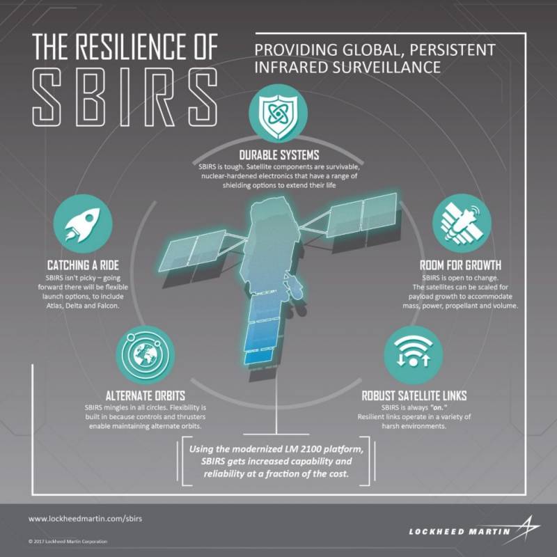
According to known data, SBIRS-GEO is equipped with infrared cameras with advanced optics. The exact composition of the equipment and its characteristics are unknown. At the same time, it was reported that the cameras are capable of detecting missile launches by engine flares, incl. less bright flashes of tactical complexes. In addition, they can be used for infrared photography of the area for reconnaissance in the interests of the troops. Detection data or images are transmitted to the ground control center as quickly as possible.
Similar devices are used as part of the SBIRS-HEO module. It is designed as a compact unit for installation on existing satellites of various types. In this case, power supply and data exchange are carried out at the expense of the platform apparatus.
Ambiguous result
About 15 years passed from the start of preliminary studies to the launch of the first satellite with the SBIRS equipment. A full-fledged spacecraft of a new type was launched even later. In addition, the SBIRS program went beyond the original budget, and the Pentagon had to cut plans to build the group.
There are currently six SBIRS-GEO spacecraft and up to four SBIRS-HEO modules in orbit. As far as is known, in general they cope with their tasks of reconnaissance and detection of missile launches. Nevertheless, the further construction of such a group was considered inappropriate and the development of new NG-OPIR devices was launched. How successful this project will be, and whether it will be able to do without the characteristic problems of its predecessor, time will tell.
Information