How the Bundeswehr will attack Russia with vector maps

106

I read an article in one of the Western publications, in which the author stated his own opinion with further proof of the preparation of one of the NATO countries for a war with Russia. Well, any person has the right to have his own point of view on absolutely any issue. And this evidence seems to be quite serious.

Of course, any action by the opposing side can be viewed as preparation for war. In fact, this is the case. The economy is being raised - they are preparing to defeat us. They accept new weapons - the same thing. They are putting things in order in their own armed forces - for a reason, for a war! Even new textbooks for first graders can be viewed in the same vein.


But you can't go to insanity?

The world is changing rapidly. The person is improving rapidly.

Remember the famous saying about a fishing rod, which must be given to a hungry person so that he can catch a fish himself?

Tell me honestly, at least for yourself, how many people can, having received this very rod, really catch a fish?

In theory, everything, but in practice?

Therefore, my reaction will be a little frivolous.

In the form of a statement to the police from a vigilant citizen living in rural areas, where few people use the Internet, rarely watch TV, and in general, people live there in an environmentally and informationally clean space.

Let's smile


To the district representative of a rural settlement
Junior Sergeant Vasily Petrov
from the villager's grandfather Matvey Ivanov.

Secret report.

Comrade junior sergeant Petrov, I, grandfather Matvey, a hereditary trackman of railway tracks, fulfilling my duties to inspect these very tracks, discovered an enemy newspaper in an incomprehensible language.
My grandson, also Matvey, a 6th grade student of our school, said that the newspaper was written in German.
Using my own authority among the population of the village, I asked our teacher Varvara Petrovna to translate the enemy newspaper and found there secret material about the impending attack on our country and our village.
And since we have few young people left, there is no one to defend the village, I ask you to inform Putin Vladimir Vladimirovich personally about this fact, so that he send us a soldier and at least some weapon... Better - a few tanks and at least one plane.
Vasya, the Germans ordered maps of our village, and of the country too.
Yes, not simple maps, but some kind of vector!
When do you need cards?
Or when you are going to go somewhere, or when you are going to seize something by military force!
So, in this secret article it is written that I ordered these very vector maps from their Bundeswehr!
The very ones that once roamed our land until they were snatched away from our fathers and grandfathers by insolent mugs to the fullest?
And I am sending you that newspaper too.
Maybe we translated something wrong?
Let the authorities figure it out.

Respectfully yours, lineman grandfather Matvey.

A little serious


Everything that is written in the "secret report of grandfather Matvey" is true.

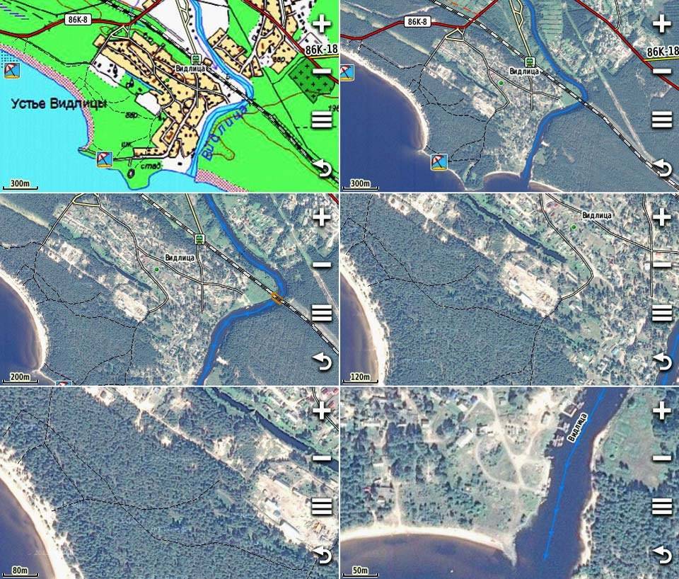
According to Western sources, the Bundeswehr actually ordered high-resolution vector maps (1:50 000) of the territory of the Russian Federation. Moreover, since the order was classified, it was handed over to the consortium ARGE VEKHA without any tender.

This company is well known in certain circles for the fact that it collects high-resolution data. For example, it is there, along with other subsidiaries, includes Infoterra, one of the world's leading providers of satellite and radar data and services in this area.

This was reported by the German edition of the World Economy. The publication is respected, but sometimes too timid. What is this small excerpt from the article worth:

“... military maps based on satellite imagery. These images show not only the earth's surface, since work is also carried out in the infrared and radio wave ranges. This means that you can see everything on these vector maps! "

Scary?

You open the map in the tablet, and there is not only the city, but also the streets of this city, houses, roads and even parks and squares! Even motorists chuckled after reading these words. I won't even write about the sailors. They really see everything on the maps. Not only the outlines of the coast, but also the depths, shallows, underwater reefs, currents and more.

For the average user, the card is the card. There are detailed ones, for use, for example, in settlements, and there are less detailed ones, for example, for studying the geography of the planet. And what is it called - no one even thinks about it.

Why it is believed that military maps contain some very secret information, for example, I do not understand. In the modern world, where there are satellites and other means that allow you to see almost everything in someone else's territory, it is almost impossible to see something else.

If you look at the declassified maps of military operations during the Great Patriotic War, then everything will immediately fall into place. Civil and military maps differ only in the coordinate system used for the map data.

The military does not use geographic coordinates, but the Gauss-Kruger coordinate system. Or the transverse Mercator projection, if you look more broadly. Quite simply, then (for not particularly military people) the Earth is simply divided into squares, taking into account the rounded shape of the surface.

The appearance of fears among the layman is often associated with ... a simple misunderstanding of the words that are used in press materials.

Scary vector maps are just a database of map features. Building heights, river speed, wind strength, object names, street widths, and more. It is clear that such cards are a new phenomenon associated with the development of information technologies.

Let's finish with the continuation


It was not in vain that I started the material by mentioning the saying about a fishing rod for the hungry.

Studying the materials of joint exercises, Russian and foreign, especially from Western countries, I periodically come across the same opinion. Soldiers of units of the American or any European army shoot well, work professionally on objects, own hand-to-hand combat, but ...

They are completely lost in the event of emergency situations that make up a real war. The American Ranger can ride almost anything, but in the event of a breakdown, he has absolutely no idea what is under the hood of the car.

They perfectly navigate the terrain, using the most advanced location systems, but the usual compass terrifies them. Roughly the same as the story of the OBZH teacher about the moss on the north side of the tree trunk, as the majority of Russians have. Everyone knows about this, but finding this very moss, and hence the north, is a problem for most.

The development of modern technologies cannot be stopped. Vector maps are modern technologies. This is help for everyone. Including for the military. Everything changes. And it transforms quickly. The example of Syria is a fine example of such changes in military science. As well as the emergence of hypersonic weapons.

So it is necessary to notice any actions, especially by the military of other countries, but it is stupid to panic about every such occasion. Ultimately, the army exists in order to be ready not only to repel the aggression of another state, but to punish for these actions already on foreign territory. This means that soldiers and officers must be prepared for such actions in every sense of the word.

This is the answer to the final phrase of the author of the material from World Economy:

"Point! Maps with such a density of information are of interest only if military operations are planned in the specified geographic area. "
106 comments
Information
Dear reader, to leave comments on the publication, you must sign in.
  1. +6
    26 October 2021 11: 09
    I don’t know how with the vector, but in the school we had samples of training maps of some NATO countries on our stand ...
    My topography was "excellent", but looking at those sheets and I would "... fall into a stupor"! laughing
    Very NOT informative and ... "poor" or something ...
    1. +7
      26 October 2021 11: 16
      Quote: Leader of the Redskins
      Very NOT informative and ... "poor" or something ...

      I confirm! Absolutely "empty" when compared with our GS.
      1. +13
        26 October 2021 11: 20
        How the Bundeswehr will attack Russia with vector maps
      2. +1
        27 October 2021 07: 31
        Our pilots compare their maps with our pack of Belomor. Maybe they are encrypted, or maybe they really can't draw cards
    2. +6
      26 October 2021 12: 18
      Are modern maps really to get rid of the compass and ruler for the infantry?
      Of course not (although the infantrymen are not superfluous)! You can use them to build routes for cruise missiles, select points for airstrikes with an accuracy of meters.

      And this is what should be alarming ...
      Recently, the US tactical nuclear weapons in Europe have been modernized, namely the B-61 mod 12 bombs, which have been modified to high-precision ammunition, have reduced the possible power (variable from 340-170 kt. And below).
      Exercises were carried out, when these ammunition was placed on Bundeswehr aircraft, trained Luftwaffe pilots (yes, yes) to use nuclear weapons. Such actions are prohibited by conventions, and this did not stop the "partners".

      But our General Staff is also aware that it doesn’t slurp soup with bast shoes. We also have accurate satellite and aerial photographs. The Open Skies Treaty was signed and not in vain. The fact that it has lost its relevance does not nullify the results of inspections.
      1. KCA
        +5
        26 October 2021 14: 11
        Colored 3D relief maps of Europe showing heights were shown to me in the Western World War in 1992, in the middle of the box there was a healthy screen more than 1x1m, it was standing horizontally
        1. -1
          26 October 2021 22: 36
          Man, ZGV in 1990 seems to have been completely withdrawn.
          1. KCA
            +2
            26 October 2021 23: 56
            Completely withdrawn in 1994, teach materiel
    3. NKT
      +1
      26 October 2021 21: 36
      This is because they did not have their own Kudryavtsev.
  2. +5
    26 October 2021 11: 10
    These are not "pixels", Vector graphics are much smaller. Easy to modify / merge with new data. Q You can get three-dimensional models calculated on the basis of the information received.
    - if military operations are planned in the specified geographical area.
    It is clear that for an attack. For a defense map, for example, Poland, which is located between the FRG and the Russian Federation.
    PS As the "city grandson" would say, and the cards are "marked"
    1. +1
      26 October 2021 17: 32
      These are not "pixels"
      that's exactly what is not raster! Vector graphics do not change clarity when changing resolution. As a former CorelDraw user and regular Photoshop user, I declare hi
    2. +1
      27 October 2021 06: 25
      Yes. When they start to prepare maps of your territory - this is a reason to think. But then it will be: what about us? Born again in Europe.
    3. 0
      27 October 2021 16: 42
      Since when has Poland been located between the Federal Republic of Germany and the Russian Federation? And you don't need vector maps for this - a school atlas is enough!
  3. -4
    26 October 2021 11: 16
    "Everything is calm in Baghdad", of course, they are doing all this only for the sake of pure curiosity, it is possible to further destroy their production facilities, to destroy mobilization resources.
  4. +2
    26 October 2021 11: 18
    The Germans are just right, but the author did not see the difference even in old paper maps between military and civilians ... and this author writes on VO ... I'm shocked, dear edition ...)))
    well, with the fact that the military should always be ready to fight, it's obvious
  5. +6
    26 October 2021 11: 24
    OBZH teacher's story about moss on the north side of the tree trunk
    actually a rare delirium, moss grows from the shady side and maybe from the south or west, depending on the landscape
    1. +7
      26 October 2021 11: 26
      Sometimes the moss goes north, it turns out, everywhere and even up smile
      1. +2
        26 October 2021 11: 30
        in our Kaliningrad region because of the importance it is always so, the forest is guided by moss, then figs where you go, you can only by the sun when there is or by the movement of clouds
        1. 0
          27 October 2021 22: 22
          in our Kaliningrad region because of the importance it is always so, the forest is guided by moss, then figs where you go, you can only by the sun when there is or by the movement of clouds


          I have no doubt that Susanin took this into account - the heroic man was and knew that the Poles would not come out of the moss swamps on moss after his death: he knew how to use the peculiarities of their native climate and terrain, the time of year. Anthills in dampness are in short supply, the weather is uniformly cloudy and the moss grows evenly ... Yes, and Susanin himself would not have left the forest in such weather, he knew that and therefore sat on the stove exactly until the Poles came - they had to lead them into the swamp on night looking. And if the weather were good, and no one would be at home, and the Poles, without finding the owners, would have left for Poland.
      2. +6
        26 October 2021 15: 27
        Quote: dzvero
        Sometimes the moss goes north, it turns out, everywhere

        At the same time, a tree growing at the geographic South Pole would simply fall under the weight of the moss. winked
      3. +1
        26 October 2021 20: 13
        And there is nowhere to go from us to the North, and there is nothing to do there ... smile
      4. +1
        27 October 2021 06: 26
        Where it is cold, moss grows on the south side. Because nothing grows at all in the north laughing laughing
        1. +1
          27 October 2021 21: 08
          Quote: mmaxx
          Where it is cold, moss grows on the south side. Because nothing grows at all in the north laughing laughing

          In summer, during the "northern or polar day" season, the sun is only from the north side for almost 3 months ....
    2. 0
      27 October 2021 10: 36
      It seems to be yes, but as far as I remember, to determine the north by moss, not only would there be a tree with moss, it should also be lonely ...
    3. 0
      19 December 2021 09: 27
      If you get lost in the forest, don't panic! Look at which side the moss grows on the trees. The sight of moss is soothing ...
  6. BAI
    +4
    26 October 2021 11: 27
    Means at the expense of the cards and the Germans.
    In 1989 I had to sail (go) on a motor ship along the Yenisei "Krasnoyarsk - Bor"
    All the way on the upper deck there were always 2 Germans and made (I think very detailed) an inventory of the route. What is the object on the shore: a noticeable stone, a cape, a house, etc. - Immediately determine the distance with the rangefinder (characteristic beeping of binoculars). Everything is entered in a notebook and on an existing map. A bird appears, an animal - everything is photographed and entered into a notebook. Well, something like this.
    1. +3
      26 October 2021 12: 13
      In 1989 I had to sail (go) on a motor ship along the Yenisei "Krasnoyarsk - Bor"
      All the way on the upper deck there were always 2 Germans and made (I think very detailed) an inventory of the route. What is the object on the shore: a noticeable stone, a cape, a house, etc. - Immediately determine the distance with the rangefinder (characteristic beeping of binoculars). Everything is entered in a notebook and on an existing map. A bird appears, an animal - everything is photographed and entered into a notebook. Well, something like this.
      How ?! Sent Cossacks, intelligence ?! belay I should have reported to the NKVD! soldier
      1. +2
        26 October 2021 13: 19
        Quote: militarist63
        How ?! Sent Cossacks, intelligence ?! I should have reported to the NKVD!

        In 1989, they (the Germans, etc.) walked around the USSR and then across the Russian Federation, as they wanted, and no one stopped them, and even helped.
        1. +1
          26 October 2021 13: 37
          It's clear! That is why I mentioned the NKVD, and not gnawed, by that time, by the worms (consensus, pluralism and Co.) of the restructuring of the KGB!
          1. +2
            26 October 2021 14: 44
            Quote: militarist63
            That's why I mentioned the NKVD,

            Correctly mentioned. Now they would be oh so needed.
      2. 0
        26 October 2021 18: 58
        Why did the NKVD, fell overboard, swam ashore to the delight of the bear family.
  7. +6
    26 October 2021 11: 36
    Scary vector maps are just a database of map features. Building heights, river speed, wind strength, object names, street widths, and more. It is clear that such cards are a new phenomenon associated with the development of information technologies.
    for a person who has been working with vector and pixel files for more than a quarter of a century, this is such utter nonsense
  8. +3
    26 October 2021 11: 49
    World military psychosis is in full swing. "Mom, we are all seriously ill. Mom, we are all crazy" (c)
    1. +1
      26 October 2021 13: 21
      Quote: Daniil Konovalenko
      World war psychosis is in full swing.

      Oh, it won't get you any good.
  9. +16
    26 October 2021 11: 59
    The appearance of fears among the layman is often associated with ... a simple misunderstanding of the words that are used in press materials.

    This is a very correct observation. The funny thing is that the author does not understand at all what a vector map is.
    Vector map - if quite simply, it is a map on which all objects are displayed using mathematical formulas.
    If a little more complicated, the representation of a vector map, like any vector graphics object, is based on a mathematical description of elementary geometric objects called primitives, such as points, lines, splines, Bezier curves, circles and circles, polygons
    In bitmaps, objects are displayed using colored pixels in a graphics matrix.
    Additional information, which was not originally on the original paper map, can be placed on vector maps and referenced to geographic coordinates. For example, about tides, currents, ports, weather forecast, and so on. In other words, the data associated with an electronic vector map form a cartographic and informational database, which significantly expands the capabilities of navigation automation in general. Only in vector maps is it possible to unload the map from images of some physical objects that do not affect traffic safety. Thanks to this, the map becomes clear and readable.
    A vector map with a wide range of zoom allows realizing dynamic electronic navigation with the issuance of many current automatic warnings to the user, for example, when approaching a danger or reaching a destination. Vector charting systems have a unique function to warn the boatmaster about a dangerous course and calculate safe heading sectors. It is thanks to the wide functionality of vector maps that all modern navigation systems currently use only them.
    That is, a vector map is, in fact, an element of a computer program.
    A raster map is just a picture.
    1. +8
      26 October 2021 12: 20
      Quote: Undecim
      The funny thing is that the author does not understand at all what a vector map is.

      he liked the word, it is now the norm to use beautiful words without understanding their meaning
      the author does not understand at all what he is writing about if he confuses the scale and resolution of the pixel file
      1. +1
        27 October 2021 07: 53
        he liked the word, it is now the norm to use beautiful words without understanding their meaning

        Quite right, and how often the term "epicenter" is used without knowing its meaning - the projection of the center.
    2. +2
      26 October 2021 12: 31
      Accordingly, the creation of a vector map of the Russian Federation by the Bundeswehr indicates the desire of the latter to improve the navigation systems intended for use on the territory of the Russian Federation. What systems can we talk about?
      First of all, unmanned vehicles. The main consumer of vector maps is a cruise missile with the ability to retarget in flight.
      Further downward: various drones, manned aircraft, artillery, ground vehicles, individual navigation aids.
      This is today, and tomorrow, on the basis of this map, systems of strategic and tactical army management and hello Skynet will be introduced.
      1. 0
        27 October 2021 11: 10
        Is it okay that vector maps have been prevailing in civil navigation systems for the third decade !? By the way, apparently everyone has forgotten that modern (civil) navigation systems have an accuracy of up to several meters, with drawn maps of almost all the planets, which is quite enough for high-precision weapons. Only here is a rocket, a map in flight does not read and does not orient itself according to the principle "I am flying over the river, here is this river on the map, now you need to turn right" .... The same cruise missiles fly according to the flight task, in which coordinates and parameters are laid flight. But this is relevant for purposes in third world countries, since modern electronic warfare systems jam or change the signals of navigation satellites and the rocket can no longer navigate by coordinates ... That is why, missiles usually have inertial navigation. Which is quite ancient and low accurate ... But, on the other hand, it does not need the help of external satellites ...
        1. 0
          27 October 2021 21: 15
          Quote: Dima L
          Is it okay that vector maps have been prevailing in civil navigation systems for the third decade !? By the way, apparently everyone has forgotten that modern (civil) navigation systems have an accuracy of up to several meters, with drawn maps of almost all the planets, which is quite enough for high-precision weapons. Only here is a rocket, a map in flight does not read and does not orient itself according to the principle "I am flying over the river, here is this river on the map, now you need to turn right" .... The same cruise missiles fly according to the flight task, in which coordinates and parameters are laid flight. But this is relevant for purposes in third world countries, since modern electronic warfare systems jam or change the signals of navigation satellites and the rocket can no longer navigate by coordinates ... That is why, missiles usually have inertial navigation. Which is quite ancient and low accurate ... But, on the other hand, it does not need the help of external satellites ...


          Stop writing complete nonsense with a smart look.
          Are you aware of the flight correction system at all?
          About reference points, for example ...
          Fiducial points are not coordinates at all, never from the word ...
          This is a set of terrain relief, which is monolithic and unchanged in a given area.

          And try the Terkom system, deceive with stupid electronic warfare ...
          1. 0
            19 December 2021 09: 42
            Why, then, in Syria, out of 60 vum BGM-109 Tomahawk, only 23 units flew to the target, and flights at the airfield were resumed the very next day?
            By the way: Terkom uses GPS for tracking reference points in case of gross deviations from the route.
    3. +2
      26 October 2021 13: 37
      Quote: Undecim
      That is, a vector map is, in fact, an element of a computer program.
      A raster map is just a picture.

      Competent and intelligent comment.
      1. +11
        26 October 2021 14: 13
        The fact is that the author's humor is completely inappropriate and shows a complete lack of understanding of the essence of the issue.
        In a special language, digital maps are created in order to provide automated command and control systems (ACCS), precision weapons guidance systems (ACS WTO) and automated navigation systems (ASN).
        Therefore, if the Bundeswehr ordered such cards, then this is clearly not a preparation for a fishing trip. Of course, you shouldn't escalate psychosis, but you need to take this moment seriously.
        1. +1
          26 October 2021 16: 27
          Quote: Undecim
          In a special language, digital maps are created in order to provide automated command and control systems.

          Vector maps are created for this purpose too, of course. But…
          Quote: Undecim
          Therefore, if the Bundeswehr ordered such cards, then this is clearly not a preparation for a fishing trip.
          But this is not a fact. For example, I created digital (vector) maps specifically for fishing trips. Well, or for mushrooms, to be more precise (I don’t like to fish, I don’t have enough patience). Nowadays, there are a lot of applications for a regular PC to create multi-layer vector maps. And to create "from scratch" on your own tracks, and to convert old raster images into a vector with further refinement and refinement according to your own data. After the production of the map, the application offers to export the file of such a map in the formats of most existing navigation programs. I made a map for that part of the Karelian forest where we constantly go on vacation. Therefore, it was super-detailed: every stone, every path, every noticeable object for several years of additions was applied, designated by its own name or nickname, understandable to all my companions-friends. That would be her Bundeswehr! He would have spat on all his aggression and went fishing. By the way, manufacturers of such mini-maps (mini - in terms of coverage area) communicate throughout Russia on the Internet and exchange their maps with those who are interested in this mini-area.
          And there is an even more famous example of collective correction of vector maps. Users actively edit the sections of Yandex maps known to them (the so-called People's Map).

          So the author in the article (without understanding what a "vector map" is) quite rightly notes:
          ... it's stupid to panic about every such occasion ...
          Moreover, there is no reason as such.
          1. +4
            26 October 2021 17: 08
            It is stupid to panic for any reason, since panic suppresses logical thinking and prevents an adequate assessment of the situation.
            However, your version that the Bundeswehr decided to spend their holidays in Russia on fishing does not seem very convincing to me. Now, if such cards were ordered, for example, by the Rheinischer Fischereiverband (Fishermen's Association of the Rhineland), then it would be a different matter. And the Bundeswehr is still a slightly different kind of organization.
            1. +2
              26 October 2021 17: 56
              Quote: Undecim
              And the Bundeswehr is still a slightly different kind of organization.

              Right. With my comment, I just wanted to show that everyone who is not lazy is now engaged in the creation of digital maps, since such an opportunity is available to any person. Well, and the Bundeswehr too, why are they worse? Only the very fact of creating such maps (and is there anyone doing others now?) Does not mean that their aggressive plans have become more aggressive than a year or five ago. The normal life of the "peacetime army".
              1. 0
                26 October 2021 20: 00
                It is generally accepted in our country that the peacetime Bundeswehr is heavily underfunded, it cuts to the maintenance of everything and everyone and is barely making ends meet. If this statement is true, then expensive mapping of a huge country cannot be considered part of normal life.
                1. 0
                  27 October 2021 12: 46
                  Quote: MooH
                  expensive mapping of a huge country

                  Read what I wrote above. The Internet is full of vector maps made by ordinary citizens for free. Or do you think that the Bundeswehr only reads reliable maps compiled by its own trusted spies? smile
                  1. 0
                    27 October 2021 14: 04
                    read only maps compiled by your own trusted spies?

                    Of course not, everyone knows that Google maps fly rockets laughing
                  2. SIT
                    0
                    28 October 2021 00: 21
                    What citizens mold is not actually cards, because you sculpt flat pictures into very limited pieces that are not yet affected by the curvature of the earth. If you make a map, then you need to create it in some kind of cartographic projection. The GIS that does this isn't cheap at all. You can, of course, dazzle on a pirated copy, but without a guarantee. In addition, such diagrams lack the main thing that the military needs - relief. I'm not talking about the depth of the fords and the carrying capacity of the bridges. In general, vector maps are the end of the last century. The power of today's even portable computers is such that having a relief matrix, you can render a space image and get a 3D image of the terrain, which is much clearer.
                    1. 0
                      28 October 2021 15: 27
                      Quote: SIT
                      you sculpt flat pictures into very limited pieces that are not yet affected by the curvature of the earth. If you make a map, then you need to create it in some kind of cartographic projection.

                      You are simply not aware of the methods available to an ordinary user. Naturally, an application that allows you to compile maps does this in a specific cartographic projection and in a specific datum (which, by the way, the user can choose himself). WGS84 is usually chosen because it is the most universal for exchange between users, but I did (so, for training) in Pulkovo-1942 (Krasovsky's ellipsoid), which is the most accurate for my area. Plots, yes, limited, exactly according to the needs of the cartographer (for himself). But, the most accurate at the current time. And the depths of the fords ... I could have indicated, only there was no need.
                      And yes, any atlases consist of different pieces.
                      Actually, I'm not going to offer my creations to the Bundeswehr (and they don't ask). My comment was initially against the author's assertion that the creation of vector maps clearly means tomorrow's attack by the Bundeswehr. Well, the Bundeswehr does vector maps, so what?
    4. 0
      27 October 2021 06: 28
      A vector map is a map in M ​​1: 1. A raster is just a photo.
      This I do not argue. Just clarifying drinks
    5. +1
      27 October 2021 14: 07
      only in vector maps it is possible to unload the map from the images of some physical objects

      Wrong.
      Computer mapping systems are quite capable of doing this on raster maps as well. Read about layered maps. Take Oregon or something. There are custom raster maps, but multi-layered and depending on the layer there is different detailing, that is, the "unloading from unnecessary" is carried out. Or, for example, in the same google map, which is raster, an algorithm for overlaying layers with a given transparency is implemented. As a result, you can overlay different tracks on the map online, which is what I use.

      That is, a vector map is, in fact, an element of a computer program.
      A raster map is just a picture.

      Wrong.
      Programs can work with both vector and raster maps, moreover, they know how to combine them.

      It is thanks to the wide functionality of vector maps that all modern navigation systems currently use only them.

      Wrong. Take the most common Yandex navigator, switch the map to "satellite" mode, oh my God, it's a raster. laughing

      The funny thing is that the author does not understand at all what a vector map is.

      Sorry, but you don't seem to understand either. You are confusing vector and raster maps with electronic and paper maps.
      1. +1
        27 October 2021 15: 54
        Sorry, but you don't seem to understand either. You are confusing vector and raster maps with electronic and paper maps.

        Wrong.
        1. +2
          27 October 2021 19: 26
          Wrong.

          I will not insist. I'm not a telepath, maybe you just made a mistake a couple of times. laughing
          In general, I participated in the development of several modern navigation systems. He even supervised on one occasion. hi Therefore, I understand very well how everything is arranged in them, and by virtue of this understanding I can briefly and clearly state this if it is interesting, of course.
          1. +1
            27 October 2021 19: 28
            and by virtue of this understanding, I can briefly and clearly state this if interested, of course.

            If you are truly proficient in the subject, an article on this topic will be welcome.
            1. 0
              27 October 2021 19: 29
              Well, from a programmatic point of view, I know for sure.
              And I'm not a topographer, of course. laughing Well, I had to figure it out in projections, coordinate systems, bindings ...
              1. 0
                28 October 2021 15: 31
                Quote: Undecim
                If you are truly proficient in the subject, an article on this topic will be welcome.

                By the way, yes. Interesting topic.
                Quote: bk316
                You are confusing vector and raster maps with electronic and paper maps.

                Have you noticed that the author of the article "about vector maps" in the splash screen has laid out raster maps smile
                1. 0
                  28 October 2021 16: 37
                  Have you noticed that the author of the article "about vector maps" in the splash screen has laid out raster maps

                  It is not hard to make a mistake here. although of course a photograph is always a raster. laughing It's just that for computer navigation it doesn't matter at all what to take as a cartographic basis. You can have a raster map, you can IMAGE from a vector map, you can take a picture from space, you can overlay them (an awesome result is given by combining, for example, a GS map and a satellite image in IR laughing ) - all the same, this base is used as a background (picture). And only on top of this picture objects (roads, gas stations, shallows, custom tracks and points) are superimposed. But these objects are not at all lines, polygons and arcs as the author wrote. These are full-fledged objects in the sense of OOP. They store everything necessary for displaying and binding by coordinates (for a road - the type of road and coordinates of all turns, for refueling - the type, icon, coordinates and !!! working time) and a bunch of service information (id of objects, id of the category, id of the type of visualization , layer, author, etc., etc.). Can you really write an article? laughing
                  1. 0
                    28 October 2021 17: 06
                    Quote: bk316
                    Can you really write an article?

                    So you haven't started yet, or what? I thought you were answering me during a smoke break while writing. laughing
                    Seriously though, the topic is interesting to many.
                  2. 0
                    28 October 2021 17: 10
                    Quote: bk316
                    It is just that for computer navigation it is absolutely unimportant what to take as a cartographic basis.

                    Sometimes it is important. All the same, the raster substrate is noticeably larger in volume than a purely vector one. With a small amount of memory and a sufficiently large number of cards, this becomes relevant. And purely visually for me, GS maps are much more pleasant than lines and polygons. smile
                    1. 0
                      29 October 2021 14: 27
                      All the same, the raster substrate is noticeably larger in volume than a purely vector one.

                      In general, yes.
                      But firstly, this is not very important with modern memory sizes.
                      And secondly, now no one stores the raster in bmp. Already jpeg gives a good result.
                      svg on map scans gives good results. Well, webp with the correct parameters generally works wonders.
                      In short, the background itself can be in any format, including vector, but these are not vectors of their topo objects, so you cannot build routing on them. By the way, the webp that gives the best results is not vectorial at all. It's functional. laughing

                      Well, I’ll probably write an article in quarantine.
  10. +3
    26 October 2021 12: 43
    I read an article in one of the Western publications, in which the author stated his own opinion with further proof of the preparation of one of the NATO countries for a war with Russia.

    The chief of this very World Economy and part-time tribesman of Staver, Mr. Sosnovsky, is a frequent guest of Shapiro aka Solovyov and propaganda low-level communities such as "60 minutes" and "Right to vote". Rebbe Solovyov even calls him respectfully "doctor", although this charlatan practicing alternative medicine does not even have a nurse's education. So, comrade Staver, you are more careful in terms of criticizing the person who is shaking hands and beloved by the central television channel. laughing This is practically not a very successful clone of your Kedmi.
    1. 0
      27 October 2021 13: 56
      And in the Bundeswehr they use tarot cards. This is "finally horror." drinks
    2. 0
      27 October 2021 21: 25
      Quote: Ashes of Klaas
      I read an article in one of the Western publications, in which the author stated his own opinion with further proof of the preparation of one of the NATO countries for a war with Russia.

      The chief of this very World Economy and part-time tribesman of Staver, Mr. Sosnovsky, is a frequent guest of Shapiro aka Solovyov and propaganda low-level communities such as "60 minutes" and "Right to vote". Rebbe Solovyov even calls him respectfully "doctor", although this charlatan practicing alternative medicine does not even have a nurse's education. So, comrade Staver, you are more careful in terms of criticizing the person who is shaking hands and beloved by the central television channel. laughing This is practically not a very successful clone of your Kedmi.

      I rarely listen to FM news.
      Sometimes Sosnovsky comes across.
      A very competent guy.

      By the way, the same Kedmi also quite clearly puts it on the shelves ...

      They have errors, I have not seen it yet ..


      How did they set you up so?
      Maybe they are not friends of Ukraine and the rest of the civilized world?
  11. 0
    26 October 2021 14: 15
    The American Ranger can drive almost anything, but in the event of a breakdown, he has absolutely no idea what is under the hood of the car.

    Well, they are so stupid. After all, you can open the hood and see what's inside.
    1. +2
      26 October 2021 14: 42
      Quote: DenVB
      After all, you can open the hood and see what's inside.

      It still needs to be opened. A year ago, in Germany, we were driving with his son with his German friend, the car stalled.
      I told him "Open the hood, I'll take a look", he looked at me as if I were a Martian. In general, my son and I opened, started. So he told us "Why, in half an hour a technical service would come, and it's not my business to climb under the hood, I pay money for it."
      We are used to repairing cars, electricity, and the washing machine ourselves, they have lost the habit of doing it. They also lost the habit of even driving around the city without a navigator. And God forbid, the GPS is cut out, the whole city will become, and whoever was outside the city will generally get lost in the forest, then they will collect them for a week.
      1. +2
        26 October 2021 15: 31
        I told him "Open the hood, I'll take a look", he looked at me as if I were a Martian. In general, my son and I opened, started. So he told us "Why, in half an hour a technical service would come, and it's not my business to climb under the hood, I pay money for it."

        It is the same in the American army. The driver will never go under the hood. This is not his business, and if he does something wrong, he can be penalized, so it is also tied to money.
        As with any system, there are pros and cons. When in our unit the general began to practice this approach, the quality of technical support increased, and the time required for this also increased.
        1. +2
          26 October 2021 15: 37
          Quote: glory1974
          It is the same in the American army. The driver will never go under the hood. This is not his business, and if he does something wrong, he can be penalized, so it is also tied to money.

          And in war no one looks, you can or should you do it. Made alive remained, no - the cross in the cemetery.
        2. 0
          27 October 2021 21: 33
          Quote: glory1974
          I told him "Open the hood, I'll take a look", he looked at me as if I were a Martian. In general, my son and I opened, started. So he told us "Why, in half an hour a technical service would come, and it's not my business to climb under the hood, I pay money for it."

          It is the same in the American army. The driver will never go under the hood. This is not his business, and if he does something wrong, he can be penalized, so it is also tied to money.
          As with any system, there are pros and cons. When in our unit the general began to practice this approach, the quality of technical support increased, and the time required for this also increased.

          Delusion
          I understand that you have never dealt with machines.
          The driver, including the American army, is obliged to make certain regulations to determine the possibilities of self-repairing a malfunction ...
          1. 0
            28 October 2021 09: 08
            I understand that you have never dealt with machines.

            What do I have to do with it? I did not serve in the American army.
            The driver and the American army, including, is obliged to make certain regulations to determine the possibilities of self-elimination of the malfunction

            About a certain regulation we are talking about. If the driver runs out of gas, of course he will not wait for technical assistance.
            But everything related to repairs is entrusted to the appropriate specialist.
      2. +4
        26 October 2021 17: 13
        I told him "Open the hood, I'll see"

        Well, you opened the hood of a modern car, looked. Make sure the engine is in place. What's next?
        1. -1
          26 October 2021 17: 32
          Aha, and there is nowhere to put a screwdriver! Everything is under the plastic! And ... closed again!
        2. +2
          26 October 2021 17: 51
          Quote: Undecim
          Make sure the engine is in place. What's next?

          A trifle, the wire on the battery fell off.
      3. 0
        27 October 2021 11: 26
        They are not accustomed, but they have been taught ... This is a society of consumers, which in the West is a model of life, promoted by the state ... Each, specific individual is a narrow specialist in his field. In the case when he needs something in another area, he attracts for money, a narrow specialist in this area ... And so in everything ... On the one hand, given the narrow specializations, services are always provided by professionals ... On the other hand , this causes a certain degradation of society and hinders development .... But the state is enough ... It would seem that the state does not care ... But the state receives taxes for each involvement of a "narrow specialist" ...
        1. +1
          27 October 2021 21: 31
          Quote: Dima L
          They are not accustomed, but they have been taught ... This is a society of consumers, which in the West is a model of life, promoted by the state ... Each, specific individual is a narrow specialist in his field. In the case when he needs something in another area, he attracts for money, a narrow specialist in this area ... And so in everything ... On the one hand, given the narrow specializations, services are always provided by professionals ... On the other hand , this causes a certain degradation of society and hinders development .... But the state is enough ... It would seem that the state does not care ... But the state receives taxes for each involvement of a "narrow specialist" ...

          Until a certain moment, when people realize that they are often not particularly professional in specifics, and they themselves are able to do the "work of professionals" ...
          But not everyone does this.

          Someone to replace the mixer calls a specialist, paying him from 50 to 200 bucks, and someone does it himself.

          Many people themselves repair bulldozers and excavators.
          There are people with absolutely no experience who repair variators and torque converters (automatic transmissions) on their own.
          Fortunately, the documentation and YouTube are enough for it.
          And parts are bought on the Internet.
          1. 0
            29 October 2021 17: 51
            Only in the west it is rather an exception to the general rule ... And the state there is fighting these exceptions, by levying taxes for what it has done for itself, or setting qualification requirements (roughly speaking, you have no right to do if there is no necessary piece of paper)
            1. +1
              30 October 2021 00: 21
              Quote: Dima L
              Only in the west it is rather an exception to the general rule ... And the state there is fighting these exceptions, by levying taxes for what it has done for itself, or setting qualification requirements (roughly speaking, you have no right to do if there is no necessary piece of paper)


              And where did you get information about any taxes, if you did something to yourself?

              Different areas.

              Construction in the same USA completely prohibits tyranny.
              You can build for yourself, no one forbids.
              Only now, the self-builder (as well as the official developer) is obliged to report for each stage of the construction to the inspector on the CODE (such as our SNIs), who really controls how the soil is dumped, how the pit is prepared, how the formwork is made and the fittings are connected, etc. ... how the pipes are laid and how the wiring, how the vapor barrier is made ...
              Every, absolutely every stage - preliminary and final works are coordinated.
              And it's all free and all the next day.

              Cars are repaired by everyone - "not lazy".
              Realistically, if not lazy.

              Most long-range, even punctured wheels do not change themselves.
              They get paid.
              For they believe that they can afford it.
              Pay $ 500 mail for the field crew work, not counting another $ 400-500 for a new tire.
              And they also pay $ 300 for an oil change ...

              And who wants to do everything himself.
              And saves.
              And there are a lot of them too.
    2. +2
      27 October 2021 21: 27
      Quote: DenVB
      The American Ranger can drive almost anything, but in the event of a breakdown, he has absolutely no idea what is under the hood of the car.

      Well, they are so stupid. After all, you can open the hood and see what's inside.

      Never mind.
      People write nonsense.
      Any native of an American farm now is approximately equal to our collective farmer of the 80s ...
      Those. can fix everything with his own hands.
      There are many observations on this.
      The only problem is that we have no collective farmers for many years. And they had farmers, are, and will be ...
  12. 0
    26 October 2021 15: 37
    Quite simply, then (for not particularly military people) the Earth is simply divided into squares, taking into account the rounded shape of the surface.

    This is where the main problem is concentrated. The earth is divided not only into squares but also into rectangles. Different countries use their own system, closer to the equator, more precisely one, closer to the poles, more precisely the other. How do the Americans dock their system when conducting hostilities at the poles? We get a lot of mistakes.
  13. 0
    26 October 2021 17: 00
    Moss grows wherever it wants, especially in the forest. Where the shadow with water grows there. And the cardinal points are the Sun and the stars. And how lucky.
  14. +5
    26 October 2021 17: 53
    Mercator projection

    Often, because of the Mercator projection, ordinary people think that Russia is absolutely gigantic in terms of territory, and Greenland is larger than Australia. But it is more convenient for sailors (and not only) to work with her. And here are the real sizes of countries:

    There is also an interesting site where you can play around by moving countries and comparing their true size. It is called "True size of countries".
  15. 0
    26 October 2021 17: 54
    "The person is improving quickly."
    Sorry, but that's not true.
  16. 0
    26 October 2021 17: 56
    "Tell me honestly, at least for yourself, how many people can, having received this very rod, really catch a fish?"
    Stupidity, please me a net and ammonite.
    1. +1
      27 October 2021 21: 35
      Quote: Sergey Averchenkov
      "Tell me honestly, at least for yourself, how many people can, having received this very rod, really catch a fish?"
      Stupidity, please me a net and ammonite.

      And if all the same a fishing rod?
      Are you going to catch the net and the ammonite?
      For what?
  17. The comment was deleted.
  18. 0
    26 October 2021 18: 00
    "people there live in an environmentally and informationally clean space."
    Again, not true, we have Internet, albeit satellite.
  19. 0
    26 October 2021 18: 17
    "Fearfully?"
    Yes, not really ... I worked for some time in topographic maps, they checked me for 3 months (if I have connections with someone and if I am trustworthy enough. But in those maps everything that you can think of is noted. along the route, naturally you cut sheets. Do you know how these scraps were destroyed? The chief of staff, I and the head of the 8th department went to the urn on the porch and burned all the scraps that had been checked for compliance before. After the act was signed and we dispersed. only the chief of staff and the same chief of the 8th department could have a room. That's it. Even the commander of the regiment could not. These were the maps, and your vector ... sorry, just laughter.
    1. +1
      27 October 2021 22: 37
      Quote: Sergey Averchenkov
      These were the maps, and your vectors ... sorry, just laughter
      with information 10 year old at least? Google refreshes its pictures annually, Yandex after 2 ...
      Accuracy on household navigators up to 1 meter ....
      1. The comment was deleted.
    2. SIT
      0
      28 October 2021 00: 09
      In aviation, maps of a scale of 1: 500 were used. This is 000cm 1km. You can only fly on them. There is nothing to do with them on earth. Secret maps began at a scale of 5: 1, i.e. in 50cm 000m. You can still navigate by them somehow. The most accurate ones are 1:500 1, but only the General Staff in SK25. If the civilian version with SK000, then they will not get out. You just take a thread of the river with a margin upstream or downstream, you reach it, and then along it you go out to the crossing.
      1. 0
        28 October 2021 00: 27
        You are mistaken, very detailed maps, just 1: 50000. I served in the army aviation - helicopters.
        1. SIT
          +1
          28 October 2021 00: 34
          Helicopters, yes, that's another matter. And how did they fly over the gluing with the cut-out frame design? It is also possible not to determine the square if you cut it heavily. Then the snail won't help either. Purely on the landmarks from the map?
          1. 0
            6 November 2021 15: 17
            Sorry for being late with an answer - an unexpected business trip. Honestly to tell you? I don’t know how they flew ... I just did as I was shown, but to mine the outside frame (I don’t remember well, 84th) remained on the outer contour. Yes, and I did not work there for a long time - a couple of months, and then I also flew into the OK to the airfield. :) And what to do with me if the admission is already there?
      2. 0
        28 October 2021 07: 35
        Quote: SIT
        The most accurate are 1:25 000, but only the General Staff in SK42. If the civilian version with SK63, then they will not get out. You just take immediately with a margin up or downstream which thread of the river, you reach it, and then along it you go out to the crossing

        The maps include and will there are 6 farm points - burned down during fires in 2019 ... and on Google images you can see the remnants of buildings. Yandex also updated this year and the ruins are also visible well
        You walked to housing and people, and you went out to the ashes - according to the maps ...
        1. SIT
          0
          28 October 2021 20: 32
          Yes, updating maps is a long and costly business and is now outdated. Modern computers allow you to work in 3D and there is no need for a flat picture. Only a regular Google image has an orbit ballistics reference and a radiometric correction. These images are linked to WGS84. This ellipsoid of revolution has a reference point at the Greenwich Observatory, i.e. errors are already accumulating on our territory. As a result, the picture may slide down to 19m-30m. This is acceptable for navigation. All the same, it is more accurate than square 12-17 for snail 5. But for shooting with high-precision weapons not with a special warhead, this is a bit too much. Therefore, either the real one, not the Ministry of Internal Affairs, the Federal Penitentiary Service, or some other maroon takes, the special forces crawls on their belly and sets up an inertial guidance system in the target area, or we take the same general staff 1:25 000 we remove the landmarks from it and use them to accurately link the picture ... Then we digitize the relief from it, make a digital terrain model instead of contours and get an orthophoto transformed image, according to which super duper smart missiles can be launched. Therefore, I would not be in a hurry to happily drive the old General Staff 1: 25000 to the Bundeswehr. You can't put a euro in a coffin, and the coffin will not be unnecessary - there will be nothing to bury, just scraps.
          1. 0
            29 October 2021 02: 25
            Mmmmmm .....
            I was talking about about 1 meter error at the corners of burnt buildings ... no more ...
            And even more so, he did not offer to distribute cards to the right ...
  20. +1
    26 October 2021 20: 12
    A vector map of Russia at a scale of 1: 15000 has been posted on the Roseestra website ...
  21. AML
    +2
    26 October 2021 23: 57
    Quote: ism_ek
    A vector map of Russia at a scale of 1: 15000 has been posted on the Roseestra website ...

    when there will be heights, then it will be maps, but for now - for general development.
  22. 0
    27 October 2021 13: 02
    I subscribe to what was said above about the incompetence of the author. Vector maps (meaning the data format) is a modern GIS, moreover, the vector data itself, it is the geometry that usually always comes with various metadata (for example, if the polygon is a building, that is, information about the height, purpose of the building, etc.) and usually for a long time everything is presented in the form of a database, where the layers of the map are stored in tables, and a typical table contains a "spatial" field in which geometry is stored in other fields, various information on the basis of which various analytics can be built.
  23. 0
    27 October 2021 14: 40
    a map is a drawing of the earth's surface. for the author to understand what it is,
    and did not come up with an unnecessary quote from the wiki. "Vector graphics is a way of representing objects and images (description format) in computer graphics, based on the mathematical description of elementary geometric objects, usually called primitives, such as: points, lines, splines, Bezier curves, circles and circles, polygons.
    Vector graphics objects are graphical representations of mathematical objects.
    The term "vector graphics" is used for explanations of differences from bitmap graphics, in which the image is presented in the form of a graphic matrix "
    that's all. and all these descriptions of objects on the map are called, if my sclerosis does not change me - the legend
  24. 0
    27 October 2021 17: 02
    Article "Geography is the secret weapon of World War II."
    A map of Berlin based on intelligence reports, clippings from Berlin newspapers, aerial photographs began to be drawn up back in 1942 in besieged Leningrad in the cartography department of the Baltic Fleet.
    1. +1
      27 October 2021 17: 09
      On that map, there were streets, lanes, individual houses, backyards, metro stations and communications, water supply, sewerage, communications, walkways, the depth and width of the Spree River and canals, the dimensions of streets and squares. During the storming of Berlin, this helped the Soviet troops a lot.
  25. +1
    27 October 2021 19: 35
    Military paper maps are valuable in that, unlike "civilian" ones, they have a grid of rectangular and geographic coordinates. Vector files are easily loaded into the navigator. And I have been pushing them there when updating for 15 years, since they are almost freely available ...
  26. +1
    27 October 2021 20: 24
    Now, if only 1: 10000, but the height in 2,5 meters ... And so - what ... Again - updates.
  27. 0
    29 October 2021 08: 21
    It seems to me that this means vector graphics - unlike raster graphics, it scales very well, and an electronic map can be enlarged almost infinitely unlike raster graphics, raster graphics (photoshop) disintegrate into pixels, but raster graphics do not - an example of a CAD program, Adobe Illustrator, etc. ... They can be increased to the limit, the greater the increase, the more detail appears. It will be a good card.
  28. 0
    7 November 2021 21: 07
    Bundeswehr, Bundeswehr, what kind of Bundeswehr? As if on purpose, a nephew from Germany called today (his father is Kazakh-German, they have been living "in the Germans" for 20 years, the nephew was born there), and so, Alex (nephew) went into military service, served for a week. The funny thing is that he says that by the end of the week 6 people from his group were disappointed in the service, they wrote a waiver and went home (as they say, why was that possible?). Alex himself is still hesitating - he says that they give little fruit, the sergeants shout, and in the morning they force him - it's just horror - to stand in the ranks on the parade ground.
  29. 0
    30 November 2021 02: 57
    "The military does not use geographic coordinates, but the Gauss-Kruger coordinate system. Or the transverse projection of Mercator, if you look more broadly."