China. Exploration assets and capabilities in the South China Sea

The most significant transformation in the modern strategic stories was the transformation of China from a land power to a sea power.
This applies not only to the implementation of an ambitious shipbuilding program, but to a greater extent the strategy of naval domination, especially in the zone of political and economic domination of China.
And in this case, there is nowhere without intelligence!
Locating, identifying and tracking ships at sea are some of the most fundamental reconnaissance and surveillance missions (RiN), which any country must fulfill if it wants to exercise control over the sea area - a goal that China has long sought to achieve in the waters off the east coast.
Therefore, it is not surprising that China, especially after the early 2010s, has significantly increased its R&N capabilities in these waters, especially in the South China Sea.
Today, almost nothing escapes China's attention in the South China Sea, judging by how quickly the Chinese naval forces began to respond to the events taking place there.
Given the ship's relatively good position, heading and speed data, the Chinese naval or coast guard ships patrolling the area can now be expected to intercept it without too much trouble.
This ability has already helped Beijing better assert its sovereignty over waters within its self-proclaimed "nine-point line."
But Beijing did not stop there. It continues to invest heavily in more accurate and timely intelligence gathering assets in the area, which makes one wonder if China really intends to develop an R&N network capable of supporting an attack by enemy ships far out to sea, i.e. capable of issuing target designation to missile arms.
Why is the South China Sea important?
By some estimates, half of the world's maritime trade passes through the South China Sea.
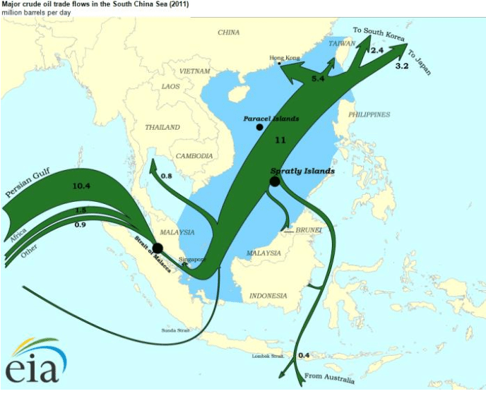
Major crude oil transportation routes across the South China Sea in million barrels per day
This is a vital route for Japan, which imports about 80 percent of its oil from the Middle East, which travels through the waters in tankers. In addition, we are talking about potentially rich underwater minerals and fisheries.
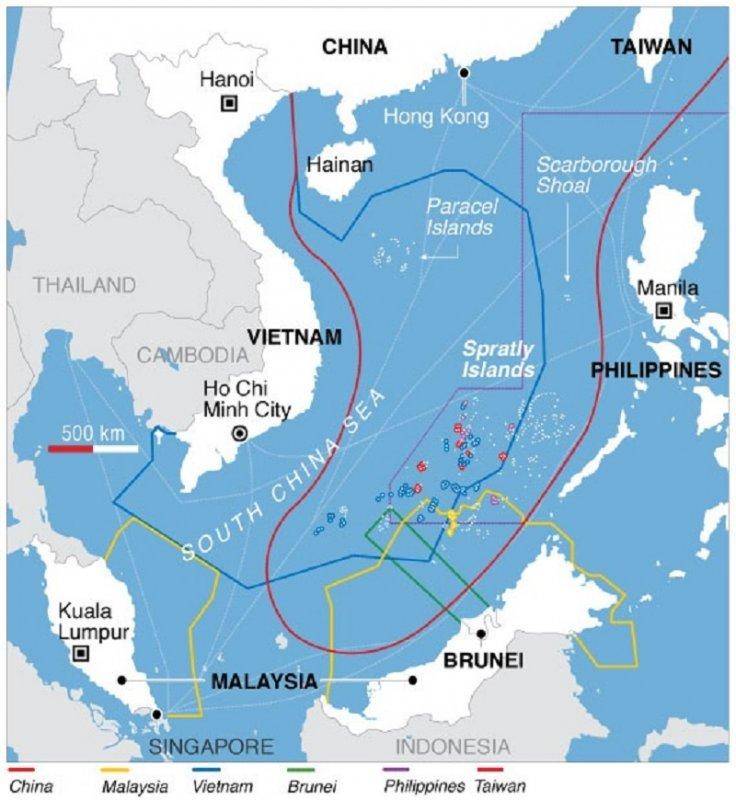
Line of nine strokes
China's vast claims in the South China Sea (which form the basis for the ongoing territorial conflict between China and its neighbors) are based on China's nine-bar line.
What is a nine-stroke line?
This is a series of "purple dashes" that loop down from China, around the Philippines and almost as far as Indonesia, and then return back through Malaysia and Vietnam to China.
They give the impression that China is laying claim to the entire South China Sea, not just land.
Beijing uses these lines to designate claims of sovereignty over roughly 90% of the disputed waters in the South China Sea. This territory extends 1243 miles from the mainland of China.
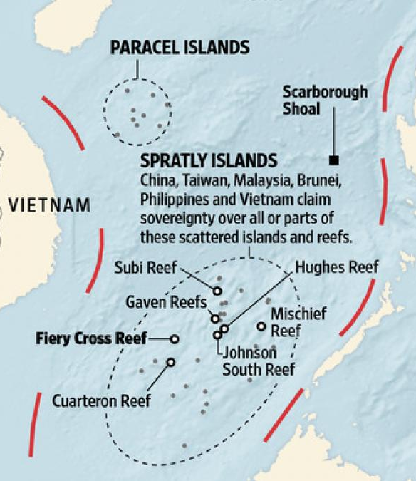
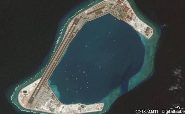
China has established many military installations in the South China Sea, primarily on the Spratly and Paracel Islands.
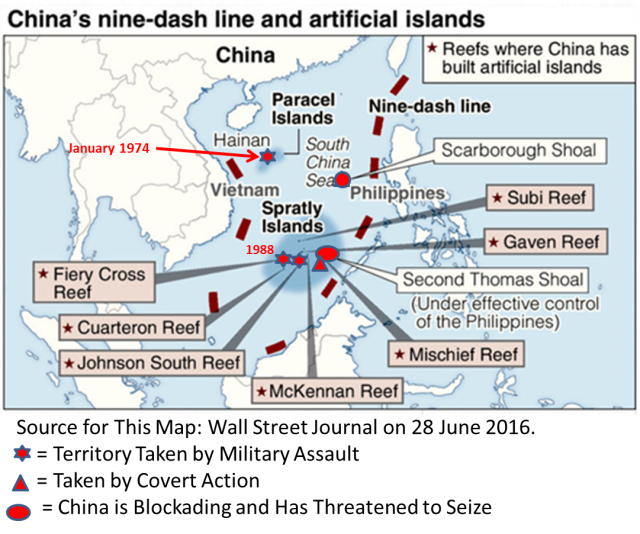
Chinese military installations inside the "zone of nine strokes"
Chinese intelligence assets
The R&N funds that China has collected in the South China Sea cover a wide range of technologies. Each has certain advantages and disadvantages. When properly networked together, they offer Chinese commanders an increasingly accurate and consistent picture of maritime activity in the area.
High frequency radio direction finding
Of all the R&R technologies used in China, radio direction finding is probably the longest used.
By intercepting the electronic radiation from the ship, the direction finding station can estimate the bearing line to it. With a bearing from at least two appropriately spaced direction finding stations, it is possible to estimate the ship's position with reasonable accuracy. The more direction finding points and the closer they are to the intended target, the more accurate their estimates will be.
This is why the 2018 satellite imagery showing the new RR and RTR site on the Chinese-occupied Mischief Reef in the Spratly Archipelago was remarkable.
This has significantly improved the direction finding network of China in this region.
However, bearing accuracy has its limits, given the technology's dependence on atmospheric conditions, which tend to change.
Severely turbulent weather in the South China Sea in summer and autumn complicates the task of collecting information. Moreover, the large amount of electronic emissions from cellular telephone networks, commercial terrestrial transmitters, and civil aircraft and ships in the South China Sea region will make it even more difficult for direction finders to separate and identify emissions from a specific object.
Satellites
Given the limitations of RR and RTR technology, China understandably sought to strengthen its maritime R&N system with satellites.
China relies heavily on the space industry, owning space-based electronic intelligence (ELINT) and communications intelligence (COMINT) constellations, as well as imaging, imaging and communications satellites.
To observe a maritime area such as the South China Sea, surveillance involves two separate tasks:
locating and identifying all vessels over a wide area, and then tracking specific vessels for a long time after they have been identified as objects of interest.
locating and identifying all vessels over a wide area, and then tracking specific vessels for a long time after they have been identified as objects of interest.
Even apart from the differences in onboard hardware, satellite orbits have a big impact on their performance. Geostationary satellites are designed to hover above the ground and are thus useful for continuously monitoring a specific area.
On the other hand, they can only do this at very high stationary altitudes of 36 km, which reduces the accuracy of the data collected.
In contrast, satellites orbiting the Earth at relatively low altitudes can collect much more accurate data. But they only spend a short time over a certain territory, leaving large gaps in their mission.
To obtain the constant coverage required for targeting naval targets, China requires a constellation of several satellites and an effective satellite control system in low Earth orbit.
China's maritime space intelligence deserves a separate article. Therefore, for now, briefly.

China's National Space Administration launched another trio of satellites into orbit on March 12, 2021, adding them to its network of spy satellites. The two previous groups, launched in April 2018 and January 2021, were launched into orbits with an altitude of about 1100 by 1050 kilometers with an inclination of 63,4 degrees.
The first Yaogan-30 triplet was launched into space on September 29, 2017. The addition of successive triplets to the same orbital plane increases the frequency of repeat visits to the survey areas.
Ultimately, a constellation of 18 satellites will be created. This will allow satellites to pass over the area 19 times per day in vertical imaging mode or 54 times per day in SIGINT mode.
Chinese media say the satellites will be used for "electromagnetic research and other testing of related technologies."
It is believed that Yaogan satellites equipped with various optical means, synthetic aperture radars and electronic reconnaissance means.
Methods and equipment are being developed for a promising series of satellites under the Project Guinean project (which means "observation of large waves") to detect submerged submarines and other objects to a depth of 500 meters.
Ground radars
China also has a large number of ground-based radars at its disposal.
Radar is the primary all-weather surveillance tool over a wide area. China has one of the world's largest radar networks.
China has even built massive over-the-horizon backscatter radars that use the ionosphere and sea surface to detect aircraft and ships thousands of kilometers away (China bought its first such radar from Russia in 2004.)
Such radars can be useful for detecting and identifying targets at a great distance. Due to the use of long wavelengths, their accuracy is limited as the characteristics of the sensors suffer from adverse propagation effects. In addition, they are subject to whims due to the variability of the ionosphere and the state of the sea.
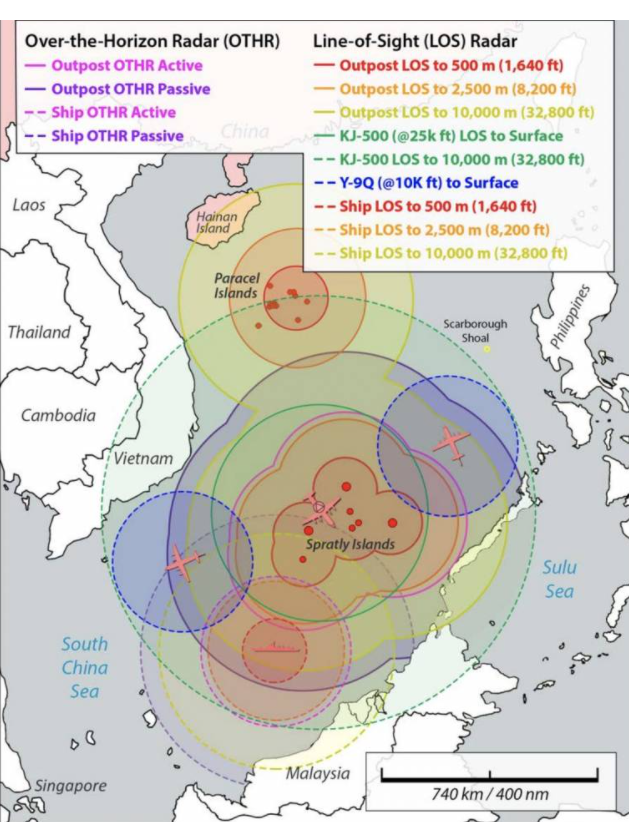
Air and ground radars in the South China Sea
Coastal radars are much more useful for reliably tracking and targeting ships at sea, but most find it difficult to reliably observe targets beyond 200–250 km offshore. So it comes as no surprise that China has announced plans to further expand its coastal radar network starting in 2014.
Among the first objects built by China on its artificial islands in the Spratly archipelago were precisely radars.
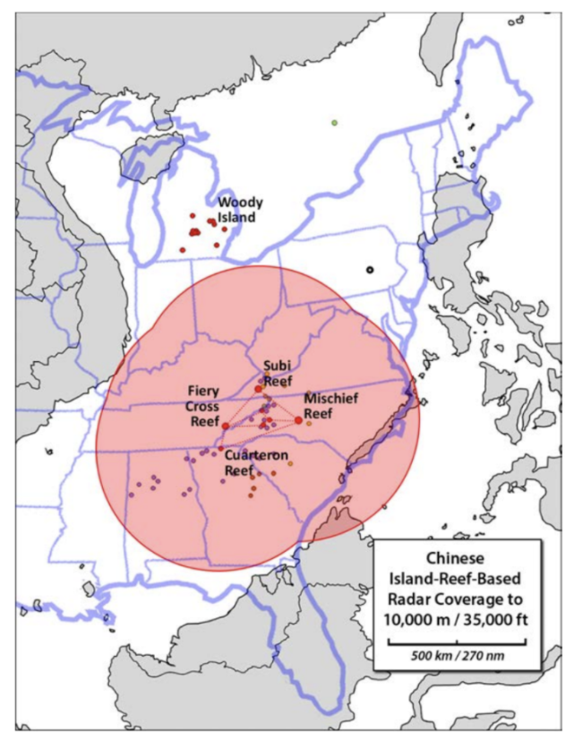
Coverage area of "island" radars
Radars undoubtedly give China more consistent and accurate information about the situation in the South China Sea. Despite this, the region's waters are vast and there are large gaps in coverage between China's ground-based radars.
This problem is solved by sea-based radars.
Marine-based radars
One way to close these coverage gaps is to build radars at sea. And this is what China started doing in 2016.
China begins construction of its Blue Ocean Information Network - a complex of radars built on unmanned semi-submersible platforms around the South China Sea.
Many of them are found in the waters of China, but some "float" in international waters.
Many of them are found in the waters of China, but some "float" in international waters.
Each platform is designed to be placed in deeper waters or to moor in shallow water, each platform is 10 to 20 meters above the water and has a surface area of 250 to 300 square meters.
As of 2020, five such platforms have been built around Hainan Island and one near the Paracel Islands.
Information network "Blue Ocean"
The Blue Ocean Information Network is being developed by the Chinese government "to assist in the exploration, operation and control of the marine environment using information technology."
According to the Chinese magazine Electronic Science & Technology, China plans to expand the "Blue Ocean Information Network" and begin the full construction of the maritime network by 2025.
The network is designed to "meet the urgent needs of the military and civilian authorities to obtain information in the jurisdictional maritime areas of China."
Naturally, this could cause concern for China's neighbors, given the ease with which the Chinese military can access data from the network's radars.
Depending on the output power, radars can be used not only for detection, identification and tracking, but also for targeting ships at sea. Confirming this, the Chinese military website China Military Online described the platforms back in 2019 as "a new system for protecting islands and reefs in the South China Sea."
China says the surveillance system is designed for weather observation, environmental monitoring and tsunami early warning, in addition to a navigation service, it will also help protect the construction of artificial islands in disputed areas.
In addition, it can be used to monitor the naval movements of other countries, including the United States.
The floating surveillance system is built by the state-owned China Electronics Technology Group Corporation - (CETC), which manufactures high-tech defense products, including sensors and communication platforms.
While smaller floating platforms are found in large numbers in the waters of the region, a larger integrated station has been installed on one of the islands. The integrated system will assist China in marine research and reef construction and protection.
It is unrealistic to assume that their sensor data cannot be accessed by PLAN for military purposes.
And they can be part of a much larger sensor network, much of which is "invisible under the waves."
This enhances China's strategic advantage over other countries in the region and can be used to track the movements of the US Navy.
And they can be part of a much larger sensor network, much of which is "invisible under the waves."
This enhances China's strategic advantage over other countries in the region and can be used to track the movements of the US Navy.
Possibilities of electronic stations
In early 2016, around the time of the rollout of its “prototype platform,” CETC began filing several Chinese patents related to “floating information monitoring system” and at least one US patent for “floating surveillance system”.
CETC patent applications detail floating platforms and many of their subsystems. The 112-foot floating platforms consist of an upper and lower deck. When deployed, half of the fixed platform is submerged for stability.

Power is provided by solar panels located on top of the upper deck. The gas generator can provide backup power if required. Wind power is also offered as clean power options, as per the system description.
Both floating and fixed platforms are designed to house a range of different sensors and serve as a link for the information they collect.
The floating platform patents contain only general references to the integration of "observing devices" that can collect data about the environment, such as flows, air pressure, temperature and salinity.
There is no specific mention of underwater monitoring systems such as sonars or hydrophones that can be supported by floating platforms, but there is a note that "other types of observing devices and auxiliary devices suitable for observing the water area may be additionally installed."
Patent applications indicate that most of the floating platform's communication functions and some of its sensitive capabilities are housed in a fairing on its upper deck.
The sensing systems include an Automatic Dependent Broadcast (ADS-B) antenna and an Automatic Identification System (AIS) antenna, as well as a small aerial and ground search radar.
Fixed platforms seem to have some capabilities that their floating counterparts do not. One notable addition is the presence of tropospheric antennas visible on the north side of the platform in photographs and satellite imagery.
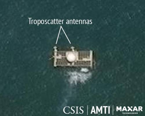
Stationary platform at Bombay Reef, April 28, 2020
Troposcatter systems provide communications beyond the horizon by scattering microwave signals from water and dust molecules in the atmosphere.
Tropospheric communications can exceed 200 nautical miles. The antennas on Bombay Reef appear to be targeting Chinese targets on Woody Island, 46 nautical miles away.
Troposcatter communication channels are extremely difficult to detect, block or intercept compared to satellite communication or other forms of radio communication.
Demonstration system of the information network "Blue Ocean"
CETC messages describe floating and fixed integrated information platforms as part of the Blue Ocean information network, which may include other components such as ocean buoys, fixed and mobile underwater sensors, including sonars and hydrophones, unmanned aerial vehicles (UAVs) ), unmanned underwater vehicles (UUVs) and unmanned surface vehicles (USVs).
The platforms deployed so far appear to be part of a "demo system" designed to test-of-concept for the network.
The platforms deployed so far appear to be part of a "demo system" designed to test-of-concept for the network.
With the help of these platforms, China has significantly increased the range of radars in the South China Sea.
They now have an unbroken chain between Hainan and its bases on the islands of Paracel and Spratly. Many of these islands already have radar stations. And one unoccupied atoll, Bombay Reef, now has one of the platforms on the coastline.
The US disputes China's vast territorial claims in the region, accusing it of militarizing the South China Sea and trying to intimidate neighboring countries, including Malaysia, the Philippines, and Vietnam, which also claim the resource-rich region.

Once again, in February 2021, strike groups of two American aircraft carriers conducted joint exercises in the South China Sea.
This came just days after a US warship sailed near the Chinese-controlled islands in disputed waters, another hotbed of tension in US-China relations.
Aircraft carrier strike groups Theodore Roosevelt and Nimitz conducted "a variety of exercises aimed at improving interoperability of forces and capabilities, as well as expanding command and control capabilities," the US Navy said in a statement in connection with the first operation of the two aircraft carriers on this busy waterway from July 2020.
A few days before these exercises, China condemned the passage of the US destroyer John McCain near the Chinese-controlled Paracel Islands. The United States has named this mission, the first of its kind since President Joe Biden took office, the Freedom of Navigation Operation.
Features
The state corporation CETC has developed at least two types of Ocean E-Stations, which are intended to expand the information collection and communication networks established on the islands and outposts of China in the South China Sea.

CETC has been promoting social media platforms since last year. The "Reef Island Information System" is almost certainly the platform depicted on Bombay Reef is an unmanned stationary platform designed to be installed on an uninhabited reef to a depth of 32 feet (10 meters).
The Moored Floating Platform Information System is an oceanic electronic station with nearly identical capabilities that can be deployed from 200 to 13 feet (000 to 60 meters).
The Bombay Reef Stationary Platform appears to be the first Chinese oceanic electronic station identified by Western media operating in the South China Sea. However, five floating platforms have already been deployed in the South China Sea, according to CETC and the China Maritime Safety Administration (MSA).
Promotional brochures provided by the CETC indicate that the Ocean E-Station platforms aim to provide electronic surveillance, maritime communications, search and rescue assistance, and monitoring of the ocean environment.
The platforms can also act as information hubs to provide power and communications for a variety of onboard or external systems, including, for example, an underwater environmental monitoring system, sonar array, or other underwater system.
The fixed platform measures 85 feet long, 56 feet wide and 32 feet high (26 meters long, 17 meters wide and 10 meters high).
The cylindrical floating platform is 60 feet in diameter and 112 feet in height (18 meters in diameter and 34 meters in height). Half of the floating platform is submerged to ensure stability.
The platform's solar panels and wind turbines generate electricity and, using a battery, provide a stable 4 kilowatts (kW) of electricity (up to 10 kW peak power) at various AC and DC voltages to power onboard and external systems.
The large fairing houses the satellite dish, radar, and other antennas. Antennas, sensors and cameras also occupy the platform perimeter. The CETC estimates that the systems have a lifespan of 20 years with routine maintenance.
Communication capabilities for both platforms include satellite communications (over 2 megabits per second (Mbps). The platforms can also relay calls from the 4G LTE cellular service and provide a link to a text messaging service available through China's Beidou satellite navigation system.
Fixed platforms also provide tropospheric scatter communications (over 8 Mbit / s) when located within 200 miles of another tropospheric scatter station.
Surveillance systems include airborne and ground search radar and an electronic signal monitoring kit. CETC brochures indicate that the system can detect frequencies from 1 gigahertz (GHz) to 18 GHz and take direction finding from 30 megahertz (MHz) to 3 GHz.
The CETC surveillance system is also capable of detecting frequency hopping distributed signals, such as the US JTIDS (Link-16) data link, according to CETC subsidiary, which manufactures electronic components for platforms.
The platforms can monitor Automatic Identification System (AIS) and Automatic Dependent Surveillance (ADS-B) broadcasts from ships and aircraft, respectively. Cameras covering both the visible and infrared spectrum provide photoelectric observation of the horizon. Several sensors are also located above and below the water for hydrological and meteorological monitoring.
These two types of Ocean E-Stations are part of the larger CETC program and the Chinese government's efforts to "inform" the marine environment ("informatization" is an inconvenient term in English, but its essence in Chinese is "transformation through information") ...
Ocean E-Station platforms and the communications and surveillance facilities they provide have both civilian and military applications.
According to a 2017 CETC press release, Blue Ocean's information network is part of a $ 300 million investment to build a "civil and military integration maritime information industry base."
Efforts to “keep the oceans informed” implies the belief that increased surveillance and communications will reduce the risk to China's maritime interests and potentially allow better control of the maritime environment.
While the deployment of Ocean E-Stations and China's marine awareness efforts appear to have begun in the South China Sea, these information hubs may well extend to other Chinese seas or even shipping routes in the Pacific or Indian Oceans.
The legal status of these unmanned systems is not entirely clear, especially in the disputed waters of the South China Sea.

China surveillance system in the South China Sea
Airborne radars
Back in the early 2010s, China's aerial reconnaissance over the South China Sea was still in its infancy and consisted mainly of Chinese H-6 bombers.
However, by the mid-2010s, China had replaced the H-6 bomber with the KJ-200, the first Chinese AWACS aircraft built entirely domestically.
More recently, China has begun replacing the KJ-200 with the KJ-500, its newest AEW aircraft, which features an improved phased array radar capable of simultaneously tracking 60-100 air targets up to 470 km away.
In 2017, the first KJ-500 AEW aircraft appeared at the Lingshou Naval Air Base on Hainan Island.
In May 2020, China even sent a KJ-500 to the Chinese-controlled Firey Cross Reef in the Spratly archipelago. And then, in December 2020, satellite images captured five KJ-500 aircraft in the Lingshui runway.
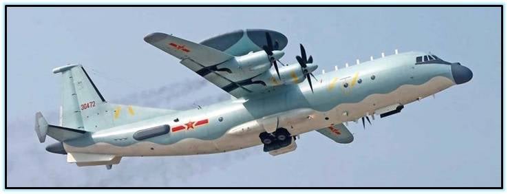
AWACS aircraft with KJ-500 ("Kunjing-500" / Kongjing-500, translated as "air raid") based on the Shaanxi Y-9 transport aircraft.
Given that China currently only has 15 KJ-500s in its entire arsenal (and its naval air force only has seven of them), the presence of five KJ-500s at one naval airbase is noteworthy.
If all of them are permanently stationed there, then China will be able to constantly maintain at least one KJ-500 over the South China Sea.
In addition to its manned platforms, China has deployed a number of unmanned aerial vehicles (UAVs) with R&D capabilities.
Of course, the payload of such UAVs is much less than that of AWACS aircraft, which means that their radars are likely to be less powerful and, therefore, have a shorter detection range.
Nevertheless, they are able to conduct "constant observation" for a long time. When directed to the right place at the right time, they can fill in the gaps in AWACS or the satellite coverage of the South China Sea.
Plans
China has significantly improved its maritime exploration capabilities in the South China Sea, not only in terms of the quantity and variety of its collection assets, but also in terms of their quality.
China's high concentration of intelligence assets clearly reflects the importance Beijing attaches to the area. It also demonstrates the magnitude of the funds that Beijing is willing to commit to monitoring the water resources it claims.
Undoubtedly, China's growing naval intelligence capabilities have allowed it to better assert its sovereignty over much of the South China Sea, let alone keep an eye on the activities of its neighbors in Southeast Asia.
The fact that China continues to deploy new and increasingly expensive R&R data collection tools, such as radars on semi-submersible platforms at sea, suggests that there may be other reasons.
One may be the desire to create a well-defended area where China's new Type 094 (or Jin-class) nuclear-powered ballistic missile submarines, based in Yalong Bay on the northern edge of the South China Sea, can operate safely.
(Just like the Soviet Union did for its naval nuclear forces in the Barents and Okhotsk Seas during the Cold War.)
(Just like the Soviet Union did for its naval nuclear forces in the Barents and Okhotsk Seas during the Cold War.)
If so, China will seek to defend such a naval bastion with its most advanced weapons. including anti-ship ballistic missiles.
And to be effective, they need the accurate tracking and targeting data that a reliable R&N network can provide.
Aftermath
Floating and fixed platforms and other components of China's Blue Ocean Information Network are of concern in the South China Sea and beyond. While the CETC has largely turned the network into an environmental monitoring and communications system, platforms and other systems clearly have military utility.
Environmental data, especially detailed, permanent hydrographic data, will enable the navy to better understand how active and passive sonars will perform in an underwater environment.
The ability to quickly move platforms and sensors during a crisis could provide the Chinese authorities with an informational advantage in a crisis.
This may include ongoing monitoring of disputed waters or disputed islands.
Obvious military applications could be the use of platforms and deployable submarine systems to close gaps in radar, submarine or communications coverage of areas.
Floating platforms also offer unique opportunities for crisis response.
For example, after a natural disaster, they can be installed along the coastline to provide air and ground radar coverage, as well as cellular communications for those affected.
The potential deployment of E-Stations and other components of the Blue Ocean Information Network in a remote region raises security, political and legal issues, especially in disputed areas.
How will other states react if China places a stationary platform on an uninhabited reef outside Paracelsus or in other disputed areas, ostensibly for ecological research?
In addition, coastal states are legally entitled to regulate marine scientific research in their exclusive economic zones and refuse permission to place platforms on their continental shelves.
This means that a deployment in the contested waters of the South and East China Seas is bound to spark protests and potential confrontation at sea.
This means that a deployment in the contested waters of the South and East China Seas is bound to spark protests and potential confrontation at sea.
CETC representatives wrote about expanding the Blue Ocean Information Network far beyond the current demonstration system and even beyond Chinese waters.
For example, in the June 2019 special issue of the Chinese journal Electronic Science & Technology, CETC officials presented three goals for the future Blue Ocean information network:
November 2025, XNUMX - Complete the construction of the Blue Ocean information network in “key maritime areas of [Chinese] jurisdiction” and begin construction of the Belt and Road maritime network. This will "meet the urgent needs of the military and civilian authorities in obtaining information in the jurisdictions of China's maritime regions."
November 2035, XNUMX - Build the Belt and Road maritime network to fully support the construction of the Seaside Silk Road in China.
November 2050, XNUMX - Expand construction to an Oceanic Polar Information Network and spearhead the development of a Global Oceanic Information Industry.
It remains to be seen how many of the CETC's ambitions can be realized. As of June, satellite imagery does not show any additional floating or fixed platforms being built at its manufacturing site in Hainan.
It's worth watching.
The Blue Ocean Information Network Demonstration System in the South China Sea is the most visible and ambitious project of its kind, using information technology to achieve China's goal of becoming a great maritime power.
China is already very close to this goal.
The question is how he will dispose of this status and his capabilities.
Information