The place of the Rakovor battle
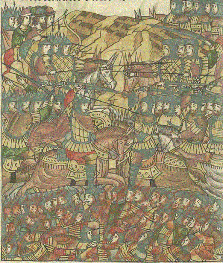
Rakovor battle. Miniature of the Facial Chronicle Code
Many people know about the Rakovor battle. But where is the battle? It turns out that historians do not care about this question. Estonian historians do not care about this, this battle is not theirs story... Although on the other hand - how to say. But Russian historians might be concerned.
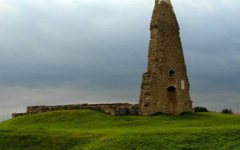
The ruins of the Viru-Nigula chapel
Usually the place of the battle is associated with the "chapel of Mary" (Maarja kabeli) in the village. Viru Nigula. And this chapel really was from the 20th century. It is believed that the "chapel of Mary" was erected at the site of the battle. But those who really know these places will say that there could not have been a battle here, that this is not the right place. From Viru-Nigula to Rakvere about XNUMX km.
No sane commander would dare to take battle against superior forces at such a distance from his fortress. And other factors must be taken into account too.
To determine the place of the battle, source documents are needed. And in reality there are two of them: the First Novgorod Chronicle and the Livonian Rhymed Chronicles.
The fact of the battle is confirmed by both sides.
It is a fact. There are two descriptions of the same event. It remains only to interpret all this correctly, based on primary sources, logic, personal experience, common sense, knowledge of the area, etc.
“In summer 6776 [1268]. Dumasha Novgorodians with their prince Yuriem, want to go to Lithuania, and inii to Poltesk, and inii to Narova.
And as if you had gone to Dubrovna, there was a strife, and rose up and went for Narova to Rakovoru. "
And as if you had gone to Dubrovna, there was a strife, and rose up and went for Narova to Rakovoru. "
From this place begins the story about the battle in the Novgorod Chronicle.
What is clear from the text read?
A group of Novgorodians led by Prince Yuri Andreevich decides where to raid. Someone wants to go to Lithuania, someone - to Polotsk, and others - across the river. Narov. Having argued a bit, they decide to go to Rakovor (Rakvere - from now on I will use modern names).
Apparently, the Novgorodians decided, using the factor of surprise, to seize the fortress, but failed. And, having lost 7 people, they returned home.
The question arises, why did they all suddenly agree to try to capture a well-fortified fortress with a small detachment?
It’s like gamble or madness, unless they’ve found out something that triggered such “emotions” in them. Or rather, revenge. And they, without hesitation for a long time, rushed to capture the fortress. This could be the news that the knights from Rakvere killed the Novgorod merchants or plundered the train. In general, something out of the ordinary. And therefore it is not surprising that later it was decided to collect regiments from all the northwestern principalities and go to take revenge on the Danes. For 7 people who died in an ordinary raid, it is unlikely that revenge would have been on such a scale.
There were masters of "vicious deeds" in Novgorod. In other words, craftsmen who can make various siege devices. And they got down to business. The Novgorod intelligence, analytics and operation planning also performed excellently. They knew in advance where and how the fortress was located, the height of the fortress walls and the exact plan of the fortress. This means that the Novgorodians had a real plan of how to besiege the fortress and take it by storm.
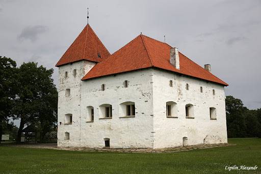
The Rakvere fortress has been well preserved to this day. And this is really a great fortification, especially for the XNUMXth century.
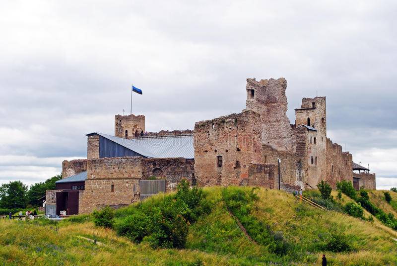
The photo shows the northern, oldest part of the Rakvere Fortress.
From the chronicle it is known that the Order is sending an embassy headed by Lazor Moiseevich to Novgorod.
"And sent her ambassadors to Nѣmtsi."
Order ambassadors arrived in Novgorod, as it is written in the chronicle, from Riga, Viljandi, Tartu and other cities. And they swore not to help
"Overcome with the call and eat the shell".
That is, with the Danes.
И
"Lazor Moisievich led all of them to the cross, bishops and nobles of God," I swear.
The question is very interesting, but who is Lazor Moisievich?
He, as it is written in the chronicle, heads the embassy of the Order, "leads" the bishops and knights to the cross to take a sacred oath on it. It can only be one person - the master of the order.
Otto was the master at that time. And at that time he was in Lithuania.
Most likely, the ambassadors actually arrived in Novgorod. But not in order, as it is written in the chronicle, to take an oath "not to help them from the Kolyvan and Rakorites." And Lazor Moiseevich arrived for a slightly different reason.
When, obsessed with the desire for revenge, the Novgorodians rushed towards Rakvere, then, most likely, their path ran through the Dorpat bishopric and partly through the territory of the Livonian Order. This is indeed the shortest route from Novgorod to Rakvere.
The Livonian Order constantly made attempts to conclude a peace treaty with Novgorod in order to stop the frequent raids of the latter. And we know that earlier such agreements were concluded with both Novgorod and Pskov. But they were not carried out.
Probably, at the time described, another peace treaty was concluded between Novgorod and the Livonian Order.
In the text of the chronicle, Lazor Moisievich says:
"We are peace with you",
Which, albeit indirectly, indicates that a peace treaty existed.
And the detachment led by the prince (the prince is an official) Yuri Andreevich de facto violated this agreement. It is clear that the plundering of the lands of the order and the bishopric was not without.
Lazor Moiseevich came to say literally the following:
revenge is your right, but organize a hike to Rakvere from the side of the river. Narova.
On January 23, 1268, the entire army left Novgorod.
There are two options for the route from Novgorod to the river. Narova: either through Luga (town of Luga), or through Pskov. The second is longer, but more real. The troops moved along the eastern shore of Lake Peipsi. On the right bank of the river. Narov and now there is a village called Perevolok. This is where the old road from Russia to Estonia passed before the city of Narva and St. Petersburg were built.
Local residents say that before the construction of the Narvskaya GRES, the river often dried up in this place in summer.
Having crossed the Narova, the regiments moved along the following route, which will lead to the place of the battle.
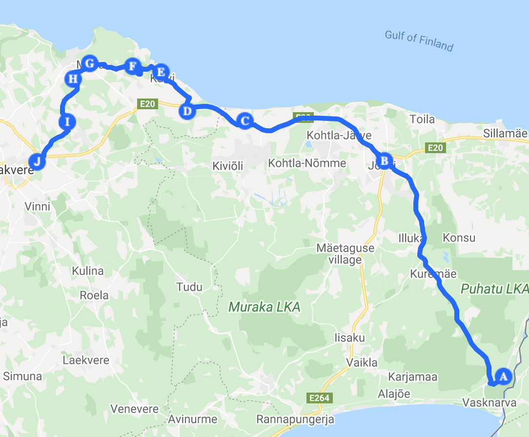
Scheme of the movement of Russian troops from the border to the battlefield
The road from the left bank of the river. Narov alone. It runs into the modern city of Jõhvi. On old Swedish and then on Russian maps this place was called Ewe.
Using old maps from open access and considering that when laying roads in those days they tried to avoid water obstacles (rivers) as much as possible. But if it was impossible to avoid rivers, then bridges were built in the most favorable place for this. Building and maintaining a bridge is troublesome and expensive.
When the route became more or less clear, it was discovered that at its key points there are still ancient buildings of varying degrees of preservation.
Purtse Castle
From Jõhvi the road led to the village of Purtse, where the Purtse kindlus castle is located. Nearby there is a bridge across the river. Then the road follows the edge of the cliff. Which coincides with the modern Tallinn-Narva highway to the Rannu village. After Rannu there are several roads towards the sea to the Kalvi manor (manor).
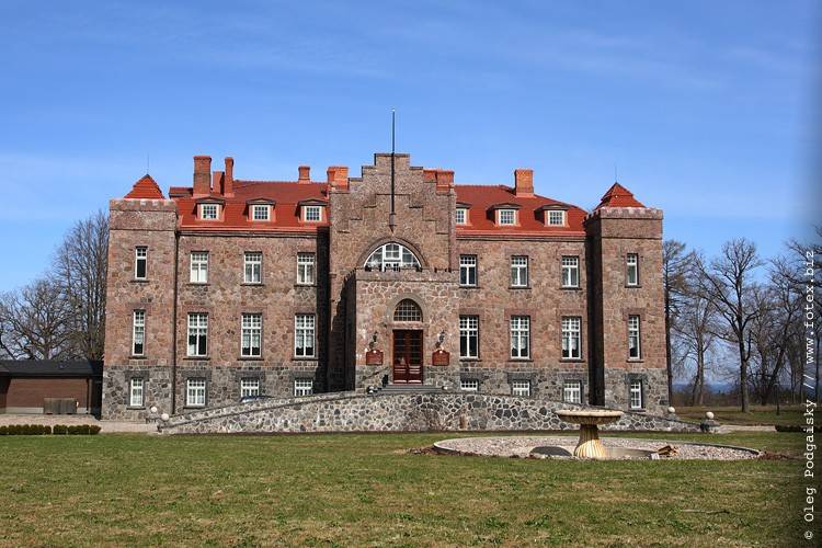
Calvi manor. Photo: © Oleg Podgaisky
Although Kalvi is now called a "manor" (manor), it is actually a medium-sized palace. And it has been beautifully restored in the 90s. Interestingly, a Danish company (Flexa Eesti AS).
At this point, the road makes a rather long descent to the base of the klint. The road starts here and goes through the villages of Pärna, Malla, Linnuse.
Now it is practically an unremarkable forest road. Small bridges were built in the forest across the river. Pada and p. Kongla. In this place, the rivers are calm and not wide.
Linnuze, in Russian it is "settlement". In the area of Linnuse r. Kunda in its course rests against the rock of the cliff and spreads over its surface, forming a ford. The depth of the ford is about 30–40 cm. But the current is quite strong.
On the left bank of the river. Kunda is an old manor house. Her current state is deplorable.
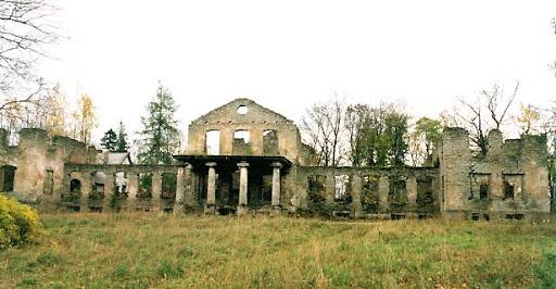
Linnuse Manor
The Russian squad spent the night here before the battle. Going down to the sea, you find yourself on the shore of the bay, which the Danes used as a port.
The road from Rakvere to the "port" passed through Linnuse. Later, the Danes will build a castle on the shores of the bay - Toolse fortress to protect their ships from local pirates.
From Linnuse to Rakvere 20 km. And from Linnuse to Sõmeru, the supposed battle site - 13 km.
By describing the route in detail, I hope to remove the questions about the advance of troops in the northeastern part of modern Estonia.
Coordinates
Е59 ° 21'54.5 "N26 ° 26'12.6" - these are the geographical coordinates where the Battle of Rakovor took place.
Using Google maps services (namely "street view"), you will see how this place looks now.
The river flowing in the immediate vicinity of this point is now called Sõmeru. And earlier it was Kѣgola in the Russian version. Or "evil rivers" in the German version of the chronicles.
Now there is an old bridge in this place. During the construction of the Tallinn-Narva highway, the Symeru riverbed was moved 100 meters to the east. The old bridge is practically buried in the soil.
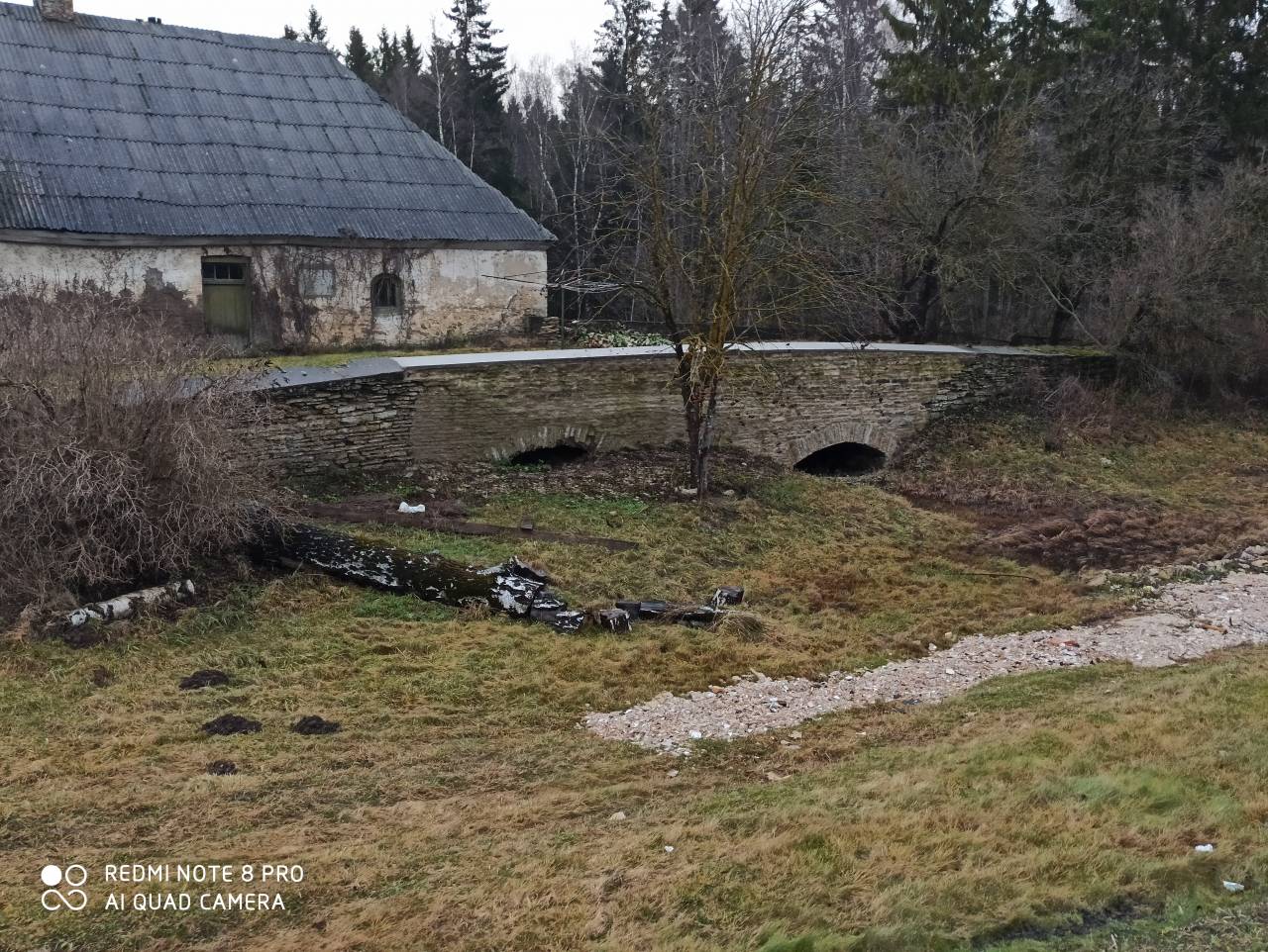
The modern view of the bridge over the river. Simeru
In this place the river Kogola flowed. And this bridge was crossed by Russian troops before the formation, preparing for battle.
Danish-Livonian troops were located opposite the bridge on a hill.
About the number of Russian troops
This is my evaluative opinion. 1200-1500 people.
With this number of vigilantes, the column in motion will stretch for 4–5 km. And the construction will take at least 1,5 hours. The longitude of the day on February 18, when the battle took place, is about 10 hours.
This also needs to be taken into account. If we assume that the Russian squads left at dawn (that is, at 7:00), add the travel time and the building time, it turns out that the battle began at about 14:00.
Sources say the battle lasted 4 hours. In other words, until 18:00. Which really coincides with the end of daylight hours.
About the number of the Danish order troops
The chronicle indicates that the detachments were from Tartu, Viljandi, Lihula. These are orders.
Paide is singled out separately from the Danish compound:
"Not much of Weissenstein, either."
Probably, really few people were sent.
Well, Tallinn and Rakvere.
There were 34 knights from the Order. But it is said that there were a lot of people with them.
The local population also took an active part in the battle.
In reality, the army from the side of the knights was probably 2 times less than the Russian troops.
About the course of the battle
I don’t think anyone will be very surprised if I note that the Danes' intelligence fully monitored the movement of the Russian troops.
And its number was known. And it was also known that the Novgorodians made siege weapons (devices). And where are they in the wagon train.
The place of the battle is chosen by the defending side. And the place was chosen very well.
Russian troops were allowed to cross the bridge for battle. There was a river behind them. Although small, but still a water barrier.
The wagon train remained on the opposite side of the river.
The Russian troops, seeing the order of formation of the enemy (the central regiment was built with a wedge or "pig" and the regiments of the right and left hand), lined up in a similar way. The main (and most numerous) central regiment (Novgorod) and, accordingly, the regiments of the right and left hand.
At the beginning of the battle, the knights (let it mean the Danish-order troops) managed to impose their battle plan. Weaker units of the knights were put up against the flanking regiments of the Russians.
And the whole battle is instantly divided into three fragments: the main one, where the knights have an advantage, and two flank ones, where the Russians are pushing the enemy. The enemy on the flanks is retreating, and the Russian flank regiments pursue him.
And only thanks to Prince Dmitry Pereyaslavsky, who struck the flank of the central regiment of knights, the central Novgorod regiment was saved.
Both in the chronicle and in the annals there is a description of a knightly military unit that appeared "out of nowhere" at the end of the battle.
It was, most likely, an ambush left by the knights on the right bank of the Kѣgola. When the battle broke out, this detachment attacked the wagon train in order to destroy the siege weapons (siege devices). Part of the detachment captured the bridge and ended up in the rear of the Russian troops,
(according to the chronicle
"Where they stood by the bridge"),
more precisely, the Novgorod regiment, and part of the detachment was destroying the train.
If this is so, then it becomes clear why the Novgorod regiment suffered huge losses and was practically surrounded. Some of the vigilantes, realizing what was happening with the wagon train, tried to cross the river (the bridge was captured). And some of them drowned in this attempt. And their bodies were not found.
Hence
"And others cannot be without weight."
"Spetsnaz" of the knights coped with their task. Most likely, the siege devices were set on fire.
Seeing the smoke, the knights began to retreat towards the fortress.
The plan of the Russian combined troops is the capture of the Rakvere castle. And the plan of the Danish-Livonian troops is to prevent the capture of the fortress.
One plan came true.
In the early Middle Ages, during the siege of fortresses, mainly three types of devices were used: stone throwers, siege towers and a ram.
Many historians believe that vices are stone throwers.
I don't think they wanted to use stone throwers during the siege. The following reasons.
1. Due to the terrain, it is difficult to install them close to the fortress, which significantly reduces the effectiveness of their use.
2. How many stone throwers do you need to carry with you to have the effect of their use?
3. Where did the Novgorodians plan to look for stones suitable for shelling the fortress in winter?
Most likely, it was a siege tower. Perhaps there was a ram too. The loss of this weapon or device completely deprived of the possibility of taking the fortress.
"Standing on the bones"
within three days - this is including the time for making a decision to continue the military campaign.
References:
Novgorod first chronicle
Livonian rhymed chronicles
Information