Chinese dragon tongue
And we tried to comprehend, who did not know wars
For the war cry who took the howl
The secret of the word Order, the appointment of boundaries,
The meaning of the attack and the clash of the war chariots!
For the war cry who took the howl
The secret of the word Order, the appointment of boundaries,
The meaning of the attack and the clash of the war chariots!
V.S. Vysotsky
The border, the edge - something hard like granite, sharp and dangerous like a blade, and beyond it something otherworldly, alien! The very thought to cross the border or go beyond the border extracts from the depths of the memory of generations:
"cross the Rubicon",
to step towards fate "headlong"
"Clouds go gloomily on the border" ...
to step towards fate "headlong"
"Clouds go gloomily on the border" ...
What can be answered to the question:
"Would Argentina become a wealthy, prosperous country if it annexed the Falklands?"
Or
"Perhaps a mighty Iraq would flourish after absorbing tiny Kuwait?"
Or
"Is Armenia much happier after the capture of several regions of Azerbaijan thirty years later?"
Over the twentieth century, the political map of the world has changed beyond recognition several times.
And always as a result of conflicts and wars, borders were revised. If a war is always a continuation of the political and economic interests of countries, then the revision of borders as a result of conflicts pursues political and economic goals.
The most stable and long-term boundaries remain between different ethnic groups if they are separated by a natural barrier in the form of a river, sea, or mountain range. Certain traditions of their observance and mutual respect of neighbors are emerging, correct and fair borders can contribute to mutual enrichment and mutual assistance of neighboring ethnic groups.
The military of all countries view existing borders as a potential front line. If the potential aggressor is strong and dangerous, then attempts are made to shorten the line of contact to organize a reliable defense. Borders established according to the colonial principle, by the right of the strong or after victory in the conflict, become a source of tension between countries and will be revised in one direction or another at the first convenient combination of circumstances.
I have never wondered if I am personally satisfied with the existing borders of our country or not? As a former military man, I was a priori required to ensure their immunity.
But lately, representatives of the diplomatic circles of different countries, whom the media provide an opportunity to be heard, and in our country, have been making hints of territorial claims against Russia. Their legitimacy is confirmed, as a rule, by references to certain historical documents, according to which we (the greedy ones) must return the illegally seized territories to our noble neighbors (in all fairness) and make amends for the historical guilt with billions in payments for the moral and material damage caused (for their underdevelopment).
As a rule, all this undercover mouse fuss is raked by the diplomatic department. And ordinary people from different sides of the border have to blindly trust the specialists who justify the point of view they favor.
Absolutely not claiming understanding and acceptance, I will try to express my thoughts aloud along one such border.
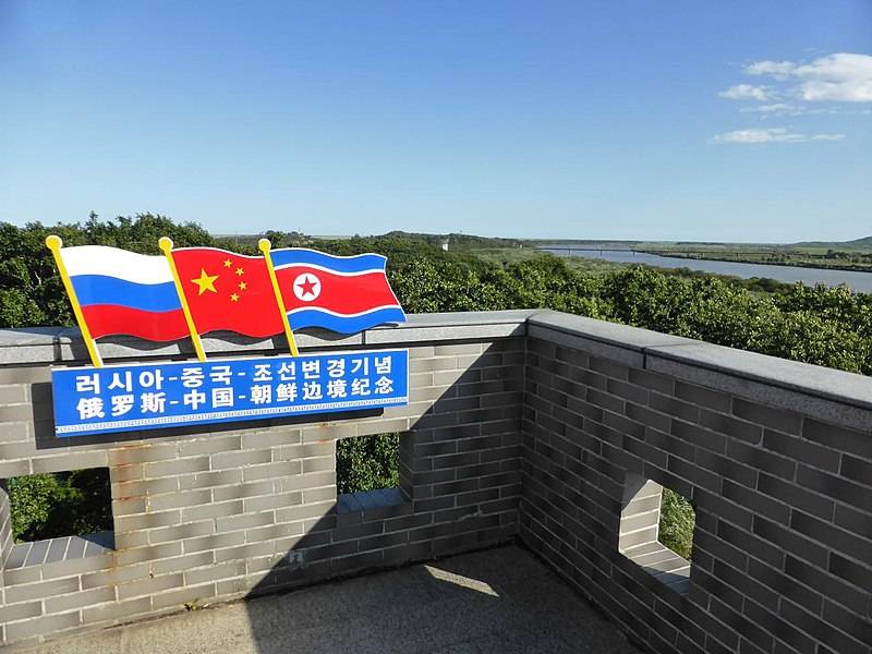
Three borders meet here now
An offer you can't refuse
It will be about the "swamp of quiet life" in the south of the Primorsky Territory of the Russian Federation along the Tumannaya River and about the border of our country with the People's Republic of China and the Korean People's Democratic Republic.
I am sure that most of us will now closely examine this place on a map at a scale of 1: 100000 for the first time. To facilitate an unambiguous understanding, I will name the resource that I used (etomecto.ru). Coordinate points and distances used in the material were taken from it.
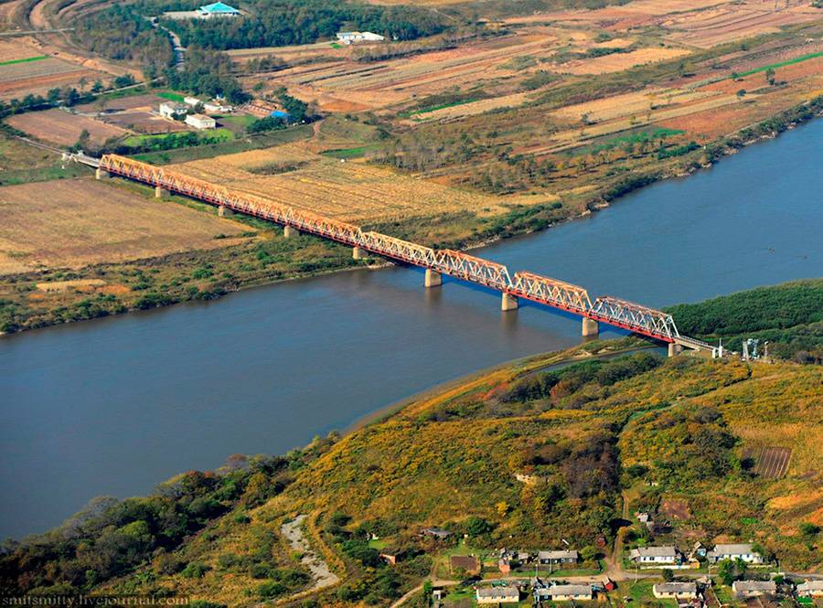
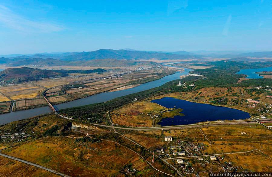
The only railway bridge linking North Korea with Russia.
So, the border between Russia and North Korea, passing through the Sea of Japan, continues along the bed of the Tumannaya River (in Korean Tumangan).
The length of the land section of the border is only 17,3 kilometers, the only crossing over the Russian-Korean border near the village of Khasan is represented by a railway bridge across the river just 500 meters from the crossing point of the borders of the three states.
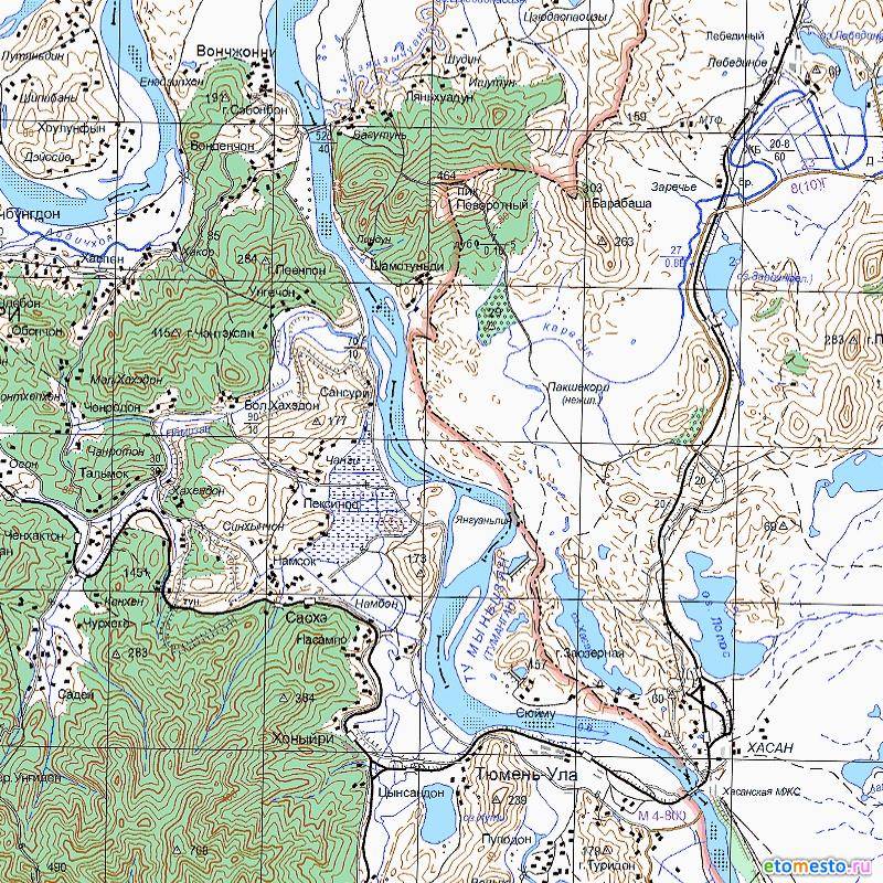
A real map of the three borders
I will note such a nuance, from this point with coordinates 130038 / v. d. 42025 / s. sh. the nearest point on the coast of the Sea of Japan in our territory is only 10 kilometers.
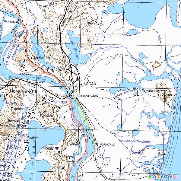
Point of intersection of three borders and its distance from the sea
If we continue moving up the river from the point of intersection of the three borders, then we will run into the next man-made structure on the border between China and North Korea - a road bridge.
The distance along the bed of a rather winding river between the bridges will be about 25 kilometers. The right bank of the river still belongs to North Korea, but on the left bank - the territory of China is a narrow strip of coastal floodplain with flooded meadows, the width of which varies from 500 meters to two kilometers in front of the automobile bridge.
After careful viewing, I have matured the romantic name of this part of the territory of China - the language of the Chinese dragon!
Along the entire length of the Russian-Chinese border in this section, the Tumannaya River, already bordering between China and Korea, can be easily seen from our side.
The position and state of the border spontaneously pulled out of my memory negative associations from times not so distant, when people from crimson jackets to the new Russian elite could afford to fence off a picturesque area on the banks of a river or lake with a blank fence in order to spend the rest of their lives, beautifully resting from work the righteous. Moreover, the craving for the beautiful of local children and the romantic memories of the youth of the inhabitants of the neighboring village were not even visible at close range.
I don’t know about you, but I, probably, because of a heightened sense of justice and innate pathological greed, had a desire to attach the dragon's tongue to the territory of the Primorsky Territory of the Russian Federation!
What advantages, benefits and benefits will the country receive from such an acquisition?
I will make a reservation right away that the act of transferring territory in this region is possible only as a result of the mutual consent of China and Russia and the unconditional approval of the DPRK.
From a military point of view, at present, the language of the Chinese dragon cannot be viewed otherwise than as a springboard for possible aggression against our country. The intended goals may be such as cutting off the land border of North Korea from such an influential geopolitical rival as Russia, in order to increase the already considerable dependence of the DPRK on the economy, politics and ideology of the PRC.
The formation of a hypothetical corridor with the PRC accessing the coast of the Sea of Japan will enable the country to claim a 200-mile economic zone and the construction of a powerful military and economic infrastructure as opposed to its eternal rival from the Japanese islands.
For the modern Chinese army, an attacking throw of ten kilometers from a prepared bridgehead and with the support of the Chinese fleet from the sea is unlikely to take more than a day. An insignificant border incident with the use of conventional weapons (and this is how the international community will be presented and perceived) will end for Russia with the loss of a significant territory in the south of Primorsky Krai.
The modern ruling elite, which has taken hostility to amendments to the Constitution concerning the country's territorial integrity, will not deem it necessary to risk a protracted military conflict without the use of strategic nuclear forces.
But let's not talk about sad things. And let's look with optimism at the possible acquisition.
Having mastered the newly obtained section of 25 kilometers of the border with North Korea, passing along the bed of a fairly full-flowing river, the issues of its delimitation, protection and defense will be greatly simplified. As an economic justification for the acquisition, we can assume the creation of a railway transport corridor from the Republic of Korea to Europe and the laying of the "Korean Stream" by analogy with the "Turkish" and "North" (one and two).
Cross-border mutually beneficial cooperation would also be facilitated by the construction of an automobile bridge, the absence of which at present should be taken as nonsense. The joint construction of a hydroelectric power station cannot be ruled out either. In the end, the attraction of labor to construction projects for the development of the entire Far East of our country (in exchange for the possibility of acquiring modern Russian weapons for North Korea) could be of interest to both sides without looking back at a partner from across the ocean.
Estimated point of intersection of three borders in the future.
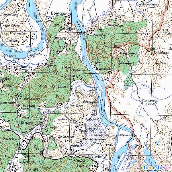
Moving the previously mentioned crossing point of the borders of three states on the Tumannaya River to the site with coordinates 130032 / v. d. 42032 / s. sh., our country will reduce the border with China by about 20 kilometers and in return will receive it on a new section with a length of only about 3500 meters. The new border will be agreed from the point indicated above on the river bed along the hollow between the hills from the south-west to the north-east to the border and currently at an elevation of 464,0 called Povorotny Peak.
Diplomacy is the art of opportunity
Is it of principle for China to own the territory in question?
As it seems to me, no. In fact, for him, this is a border zone, sandwiched between two borders with a special regime of visit and presence. Any significant economic or agricultural activity is very, very problematic. The density of the indigenous population is not comparable to the southern regions of the continental part of the country. By and large, some costs and a headache!
Of course, taking into account the mentality of the Chinese leadership and the people as a whole, who poured entire islands in the South China Sea to expand living space, we, as initiators and beneficiaries, must be ready to make mutual concessions and, perhaps, interest the other side in other ways ...
This can be either a banal exchange of territories in order to establish more convenient and fair borders, or significant actions or concessions in the economic or political spheres of relations.
Exchange option
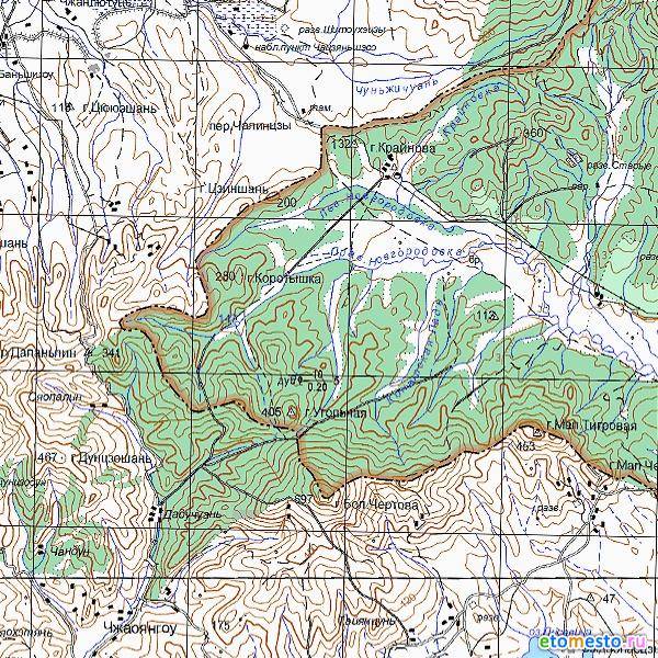
So, for exchange, as an example, we can offer a wedge-in section of our territory deep into China in an area of height 405 called Mount Ugolnaya to a height of 280 Mount Korotyshka, this is 20 kilometers northwest of Povorotny Peak. Or maybe the Chinese will be interested in a site in the area of the Guard Mountain to the west of Lake Khanka?
If you bargain according to the Eastern custom, then attempts to exchange this section for critical technologies for the PRC (reactors for aircraft carriers, engines for space rockets, which are bought by the Americans, or for the Tu-160M) are possible. Mutual recognition of Crimea and Taiwan could become a symbolic gesture in the political arena. In the end, it is stupid to buy out the land at the prices of the Moscow Ruble. By the way, can any of the local inhabitants want a dacha on the Tumannaya River in the Korean style ...
Someone will ask, is the candlestick game worth it?
From my point of view, such borderline issues should not be considered at the moments when relations with a neighbor become strained before any conflict heats up.
Let us recall fraternal Ukraine. After the collapse of the Union and the emergence of two independent states, no one paid attention to the fact that the railway route from Moscow to Rostov-on-Don on a small deserted section passed through the territory of the Luhansk region. Over time, customs appeared on it. And all the inconvenience first came down to a waste of time. And six years ago, hostilities began there. And the railway troops of the Ministry of Defense of the Russian Federation in an emergency mode had to pull the tracks bypassing the "square". And where did all the warmth of brotherly relations go !?
There will be no monumental conclusions and categorical requirements on the topic discussed in the article. At least from the author.
I apologize in advance for possible unintentional economic, political, diplomatic blunders.
In the comments, I would like to hear the whole range of opinions and suggestions on the topic outlining the civil position of the reader who has not remained indifferent.
Information