Strategists - west of Kamchatka and east of Japan

Photo: Alexey Voron, alexey-raven.livejournal.com
300 years ago Peter I founded Saint Petersburg and Kronstadt in the Baltic. 80 years later, Catherine II laid the foundation of Sevastopol. And 70 years later (in 1854), Petropavlovsk-Kamchatsky and Sevastopol adequately defended the interests of Russia in the war with the then NATO led by Great Britain.
In 1871, the main naval base of the Siberian Sea was transferred to Vladivostok. flotilla... And, finally, in the difficult war of 1916, the last Tsar Nicholas II approved the construction of the last city of the Russian Empire - Murmansk by the highest resolution.
Russia, going out to its natural natural boundaries, was fixed on them seriously and for a long time, building cities, ports and fortresses. And it was always difficult, despite the circumstances, nature, enemies.
Before the revolution, Russian naval strongholds were not more threatened than the twelve-inch battleships of the Kaiser and Mikado.
Under the Union, mine and artillery positions, a mosquito fleet, submarines and aviation... Under the USSR, the fleet became nuclear missile and reached its maximum power. Unfortunately, the quantitative and qualitative growth of the naval personnel and aviation of the Navy was accompanied by a chronic lag in the development of the coastal infrastructure, repair base, living conditions and service of the personnel. Probably, there were objective reasons for that.
Under the conditions of the new Russia at the turn of the century, the beginning of the reduction of the fleet gave timid hope for a gradual leveling of the old imbalance, but this did not happen. The only remaining aircraft-carrying heavy cruiser is still without a berth. Ships and submarines consume the service life of the units while in the bases. And the ships requiring repair and modernization are doomed to write-off.
Everyone is used to this state of affairs and is taken for granted.
Critical Fatal Flaws
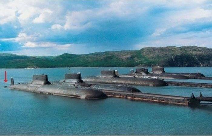
Avachinskaya Bay, Petropavlovsk-Kamchatsky, Vilyuchinsk ...
The wasp's nest, the focus of global evil, subject to primary and unconditional destruction in wartime, and a zone of close attention in peacetime for the Pentagon. Part of the naval component of Russia's strategic nuclear forces is concentrated here.
With the emergence of ballistic missile submarines, it was difficult to find the best place for their long-term deployment on a permanent basis: maximum proximity to potential targets of strike, open access to the deep-water part of the ocean and freedom to choose routes to areas of alert, convenient closed bay and the availability of port infrastructure ...
But this was the choice of the 50s of the last century.
This should never happen again.
Modern "Boreas", which are undergoing rearmament of the Navy, will not be sent on duty to California, Oregon and Washington. They should feel comfortable in the Sea of Okhotsk, the entire bottom of which, by the way, since March 15, 2014, belongs to the continental shelf of Russia.
SLBMs from an SSBN from the Sea of Okhotsk are capable of reaching any state in the continental United States. Only now the path from the bay on the eastern coast of Kamchatka to the sea off its western coast has become more and more dangerous for some time now.
Submarine warfare tactics are brutal and not sentimental. The only known and invariable constant in the equation of underwater confrontation is the exit from the Avacha Bay.
In this square, the highest probability of detection and acceptance for escort of an enemy submarine cruiser. An ambush can also be set up on the way to the Kuriles, and submarines-hunters are not prohibited from entering the Sea of Okhotsk.
Twelve MRK, MPK and minesweepers of still Soviet projects and buildings from the OVR brigade can theoretically be considered reliable protection from submarines of the Los Angeles, Sea Wolf, and Virginia types. Coastal anti-ship missile systems, S-400 air defense systems and MiG-31 interceptors will not allow the American AUG to fire a pistol shot.
The valiant REB members will "reconnoiter and land" a massive strike from the depths of the ocean from an underwater arsenal of Ohio-class cruise missiles. I really want to believe it. But let's leave questions of faith to the ministers. No certainty!
Taranto and Pearl Harbor were unexpectedly attacked in times of war and peace. And even Gunther Prien made his way into Scapa Flow. Losing battleships is a blow to money, nothing more. The loss of three strategic missile submarines will change the fate of the country and not for the better.
Paradoxical as it may sound, but the main drawback is that a strategic naval base of similar importance and class is located on the coast of the open ocean. No sea, no bay-strait, no lake or canal ...
Karl, is ocean!
This means that everything that can swim or fly here is dangerous!
The military potential of the base is primarily determined by advanced scientific developments and the capabilities of the country's military-industrial complex. Most of the ships and the overwhelming mass of the range of weapons are produced in the European part of the country - not even within the Far East Military District.
Everything (from groceries and footcloths to ballistic missiles) has to be imported in conditions of the most difficult transport logistics. For clarity, let us recall the "Syrian Express" for Tartus and Khmeimim. There is a shortage of supply vessels, all ports from the polar Murmansk to the nearest ones - Novorossiysk and Sevastopol are involved.
Note that in the European part of the country there are railways in all ports, and the entire Far East hangs in the balance of the Transsib. So, from the Peter the Great Bay to the Avacha Bay, there is a sea passage of 3000 kilometers, for which you can give a badge
"For a long hike."
For example, Arctic convoys from the UK to Murmansk traveled roughly the same distance in a similar navigation environment. In conditions of hostilities at sea, the supply of Kamchatka will have to be organized by convoys or individual ships under heavy protection. Given the enemy's overwhelming superiority in theater of operations in submarines, surface ships, coastal and carrier-based aviation, the base in Kamchatka will be blocked and destroyed - a matter of time and a volitional decision.
The bleak picture is aggravated by the harsh weather and natural conditions in which the fleet and troops are on alert and conduct daily activities.
For reference: the region of Kamchatka and the Kuriles is the most seismically active not only in our vast country, but also on the planet Earth as a whole. Any construction (and even more infrastructure facilities for the storage and operation of nuclear weapons and ships with nuclear reactors) must take this circumstance into account. The examples of Chernobyl and Fukushima are still alive in the memory of people.
Seismic activity, active volcanoes covered with glaciers, difficult terrain, maximum precipitation in the region combined with winds and fogs create extreme conditions for the combat use of aviation and air defense systems in the defense of strategic military facilities.
The conclusion is unambiguous. In other words, there can be no two opinions here, and bargaining is not appropriate here: For the sake of the country's unconditional security, the base of nuclear missile submarines with ballistic missiles must be moved to a safer and more suitable place in the Far East.
Difficult compromise choices
The choice of the location for the future SSBN base is obvious - near the village of Lazarev on the shore of the narrowest point of the Nevelskoye Strait. The name is in honor of the honored admiral. And the Gryaznaya bay can be renamed by holding a national referendum among the local population and a new garrison.
This decision will by itself push the government towards the long-awaited construction of a railway bridge to Sakhalin. Still, an eight-kilometer bridge across the Nevelskoy Strait in the narrowest place will not look like a masterpiece compared to a 15-kilometer bridge crossing across the Kerch Strait.
True, right from tomorrow you will have to start laying rails on the Komsomolsk-on-Amur - De-Kastri - Lazarev stretch of about 400 kilometers. You can, of course, listen to the cry of the liberals. But in the stagnant USSR, the Baikal-Amur Mainline was laid. And under the tsars they were honored to stretch the "piece of iron" of the CER to Port Arthur. (Also, by the way, there was a Russian naval base).
Thus, the interests of the country's defense capability, the economic development of the Far East and a mega business project with the participation of foreign capital will merge in harmony (we will silently ignore the new American sanctions).
Lazarev and Petropavlovsk-Kamchatsky are practically at the same latitude, so the climatic conditions will be very similar. But in Primorye, seismic activity is somewhat lower and Lazarev is covered by Sakhalin from the sea border. It would seem that all the shortcomings of the base in Kamchatka have been successfully eliminated, but nature once again demonstrates the insignificance of human efforts in front of its power ...
The depths of the Amur estuary and the Sakhalin Gulf of the Sea of Okhotsk do not allow the use of underwater strategic missile carriers. From Lazarev to the thirty-meter depth of the continental shelf in the Sea of Okhotsk (starting above the 54th parallel) the distance is not less than 200 kilometers.
Submarines would have to overcome this route on the surface along strict narrow fairways (accompanied by anti-mine ships and with mandatory fighter air cover).
Such events, of course, will not go unnoticed by enemy reconnaissance, primarily space intelligence.
Although, on the other hand, if you look closely, the US naval base Kitsap (combined by Bangor and Bremerton) is located no less tricky. Because of the shallow water, it is necessary to abandon both the mouth of the Amur and rather convenient bays in the region of the Shantar Islands.
Continuing to look at the western coast of the Sea of Okhotsk, we will pay attention to the Ayan Bay and the small Ayan Bay of the same name.
Quite a convenient place, but for a lower class naval base, not for underwater strategists. The forces for the defense of the Sea of Okhotsk itself, corvettes, frigates and Varshavyanka-class submarines could have settled here. But transitions to objects of interest (represented by the chain of the Kuril Islands, the straits between them and, in fact, the state border), which will last up to two days in both directions, put a big cross on any promptness of response to emerging threats and are simply economically inexpedient.
It remains to pay attention to the pearl of the Sea of Okhotsk - the Nagaev Bay and the port city of Magadan located in its depths.
Comfortable depths of a closed bay. Its dimensions (the entrance to the bay up to three kilometers wide and the length inland up to 12 kilometers) could be appreciated by sailors as a gift from Mother Nature, which she does not often do. But the language does not turn under the pressure of political superstitions (and rabid occultism from RenTV) to invite readers to connect the fate of the strategic base of the Russian Navy with the image of sunny Magadan. With the one that has developed in the country around this settlement.
In short, as from Mexico to Canada, the Americans did not find anything better than Kitsap, so fate itself ordered the Russians to develop the Ayrene Bay and the Lisyansky Peninsula.
Tmutarakan in a new way
What kind of place is it?
59 degrees north latitude and 145 degrees east longitude. Latitude of Magadan, Nizhnevartovsk, Khanty-Mansiysk, Solikamsk, Vologda, Tikhvin and St. Petersburg. Europe and America are not interesting to us.
On the same meridian with the South Kuril, which is located on our island Kunashir. In short, Sakhalin and the whole country of the rising sun is to the west.
And further north, up to the Sannikov Strait, I could not find settlements familiar to the general public. Maybe it's all for the best. Romance. But nearby in the east is Magadan (280 km), and in the west - Okhotsk (150 km).
The entrance to the Eirineyskaya Bay is wide and spacious. The distance between Cape Nizmenny on the western coast of the Lisyansky Peninsula and Cape Shilkan is 7 kilometers. The depths, both at the entrance and in the greater area of the lip itself, exceed the 20-meter mark.
The coast is formed by a chain of hills with heights of 250-600 meters. The area of the closed water area of the Eirineyskaya Bay (according to my calculations) is not less than 50 square kilometers (I did not find exact data). This is comparable to Nakhodka Bay. And much less Avacha Bay. This makes it possible to comfortably accommodate the 25th submarine division here, even if the number of Boreis grows to six units (96 deployed carriers).
The average tide is 3 meters. Similar to the value at the entrance to the Kola Bay.
The advantages of this place include white nights (as in St. Petersburg), significantly weaker seismic activity and half the annual precipitation (compared to Kamchatka).
Relative disadvantages:
- the average annual temperature is -3,8 ºС (in Petropavlovsk-Kamchatsky this indicator is +2,8 ºС);
- eternal Frost;
- only 59 days of sunshine a year, of which only 7 (one week) from May to September.
Although, on the other hand, the impossibility of conducting optical air and space reconnaissance by the enemy for the future naval base is rather an advantage.
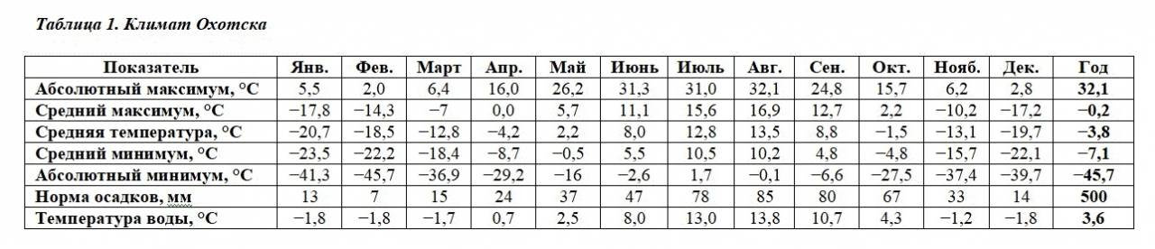
The main wind directions in this area (up to 40% of the time of the year) are north and northwest (up to 13%) at a speed of 4–5 m / s.
The place we are considering is administratively included in the Khabarovsk Territory. The distance from it to the capital of the region is at least 1400 km, if in a straight line (or rather, by air).
Although another neighboring administrative capital (with the largest in the north-east of the country, the international airport named after V.S.Vysotsky) in the Magadan region is also within 280 km from it.
The population density of the Okhotsk District of the Khabarovsk Territory in 2020 (attention) 0,04 people / sq. km. (This is disrespect for people by the compilers of such statistics. After all, one could write: one person per 25 square kilometers).
If a submarine base and a large garrison are deployed according to the ZATO principle, the Okhotsk region, within the framework of a small administrative reform, is transferred to the Magadan region. Thus, the indicators of population density will improve both in the Khabarovsk Territory and in the Magadan Region, which is incremented to it.
As Shura Balaganov said:
"In fairness!"
Military fantasy
Years later, after the departure of the 25th division and reconstruction, the Pacific Aircraft Carrier Strike Group, led by the nuclear-powered aircraft carrier, began to be based in Avacha Bay on a permanent basis. The Putin naval base and the eponymous closed administrative territorial unit in the Eirineyskaya Bay and the surrounding area become the stronghold of the nuclear missile forces of the country and the Eastern District. New formations of the fleet and the aerospace forces are being formed: a submarine division; air defense division VKS; OVR team; coastal defense brigade.
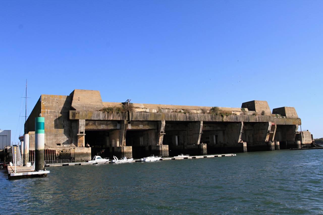
The Germans in occupied Lorient could afford it. Something more monumental should be in the "Borey".
Photo: Martin Cígler, Wikimedia Commons
In the base, underground or concrete capital shelters are created for each SSBN, an underground arsenal, a coastal dry dock. At first, the issues of heat and power supply are closed by the floating nuclear thermal power plant (FNPP) - a sister ship of Akademik Lomonosov.
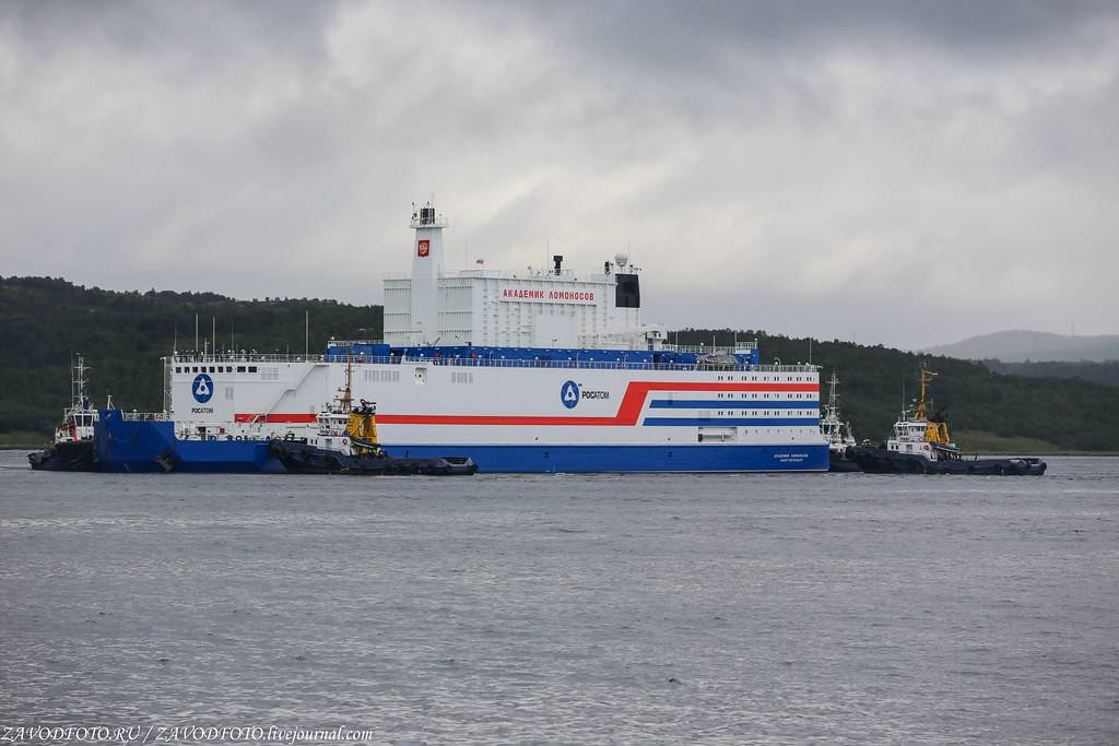
Temporary solution to energy problems. Photo: zavodfoto.livejournal.com
Having given preference to nuclear missiles, nuclear submarines and a nuclear power plant, the Ministry of Defense should not economize on a nuclear icebreaker for year-round trouble-free operation of the strategic base. It is necessary to order a series of ships more modest than the Vaygach. Something like an updated "Lenin". To work in the base and the surrounding area with a modern military flavor.
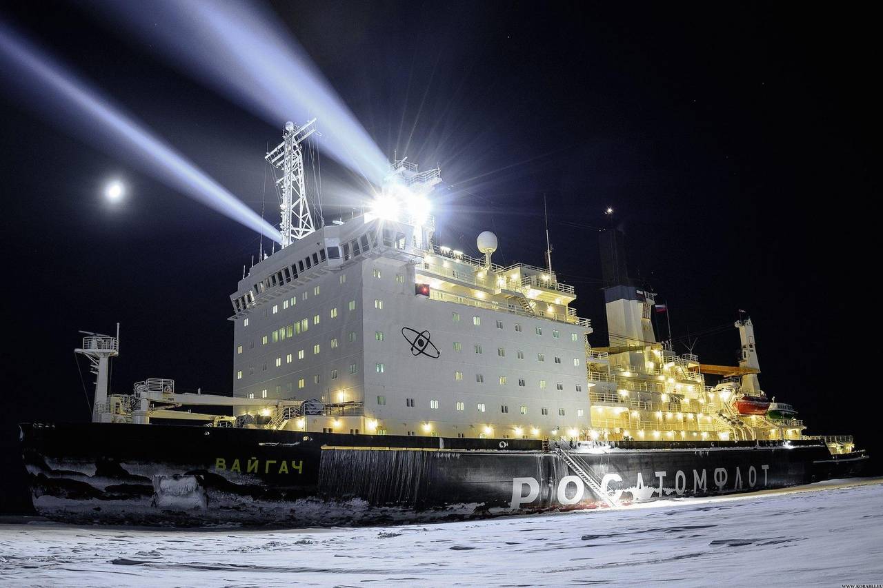
The new icebreaker is to become a lifeguard, a tug, and a sonar reconnaissance vessel. Photo: rosatomflot.ru
Logical conclusions to guide action
It has been officially announced that the strategic forces' fleet will be renewed by 86 percent; in the coming years, the pace of renewal will naturally slow down. The freed up financial resources should be used to improve and update the infrastructure for the maintenance and operation of the newest weapons received.
The relocation of the base of the latest SSBNs from the border 1000 kilometers inland makes it possible to reduce the likelihood of a preventive disarming strike with both conventional and nuclear weapons. Creation of infrastructure from scratch in a new place for specific types of weapons allows avoiding unnecessary costs for demolition and dismantling of old, attempts to adapt and rebuild everything and everything to new requirements at the expense of quality, reliability, new tactical and strategic environment.
The logistics of the new base will continue to be removed from the railway tracks in the Vladivostok area. Perhaps, in the future, with the construction of the Sakhalin Bridge and the transformation of the Lazarev settlement into a transshipment point and a developing port, the shoulder of the supply by sea will be reduced both to Petropavlovsk-Kamchatsky and to the closed city of Putin. But even with the existing starting points, the routes of the vessels will now pass mostly within the territorial waters and under the cover of coastal anti-aircraft and anti-ship complexes and coastal aviation.
The Trump administration's withdrawal within four years from the ABM, INF, Open Skies treaties (and the dim prospects of the START treaty are on the way) make our strategists from the General Staff think deeply about the consequences of these decisions of a potential enemy. And at the same time, this also opens a window of opportunity for building up both the defense and offensive potential of our country, adjusted for modern realities, and not for the epic times of the USSR.
To address the issues of safe basing, deployment and maintenance by existing and future SSBNs, it is necessary to turn the Sea of Okhotsk into safe inland waters, transforming the Kuril sieve into an insurmountable spot for submarines, ships and aircraft of crooks of all stripes. Including from the Hokkaido side.
Information