Sea warfare for beginners. We bring the aircraft carrier "to strike"

It's not that this thing has 90 tonnes of displacement. The fact is that it has a speed of 000 km / h. Is always
There is no topic that in the modern public consciousness would be shrouded in more nonsense than the detection of surface targets in the open sea and a strike on them from the shore. The consciousness of domestic citizens bears distinct signs of the Middle Ages: having created a certain idea for himself, a person then conducts all his mental constructions, starting from it as a "assemblage point", and if the facts do not correspond to these constructions, then so much the worse for the facts.
This fully applies to the mythologization of naval issues. The average citizen, as a rule, hammers into his head a kind of "anchor": we are a continental power, American aircraft carriers, cans, sink from the shore, and then builds a picture of the world around this postulate. No logic is at work here: we have 10 Daggers, which means we can sink 10 aircraft carriers, period. Do wearers of "Daggers" need to see the target? Yes, you are for the Americans! There is ZGRLS, have you never heard? Why are you pouring slop on the country? Etc.
Why is it harmful? The point is that an idea that has taken possession of the masses becomes a material force. If the whole society believes that we can already beat any enemy with one left and there is no need to do anything, everything has already been done, then indeed, “to do something” will be politically impossible: officials and statesmen are also people and basically believe in the same as everyone else. As a result, the measures necessary to ensure the country's security will not be taken. And then there will be a war and everyone will look stupid again, and the fools, incited by foreign agents of influence, will broadcast that the fleet would be LOST, then the outcome of the war would be BETTER. And this is not an exaggeration, it is enough to search the Internet for how ordinary people assess, for example, the Russian-Japanese war.
Often, however, these harmful ideas are not a consequence of the defectiveness of their carriers (although this is also, alas, not uncommon in our society), but simply a consequence of the fact that the average person cannot imagine what is really behind the concepts that he is trying to operate , and if some picture, more or less close to reality, is loaded into his brain, he will change his mind.
But how to do that? How to VISUALLY show a person that the presence, for example, of an enemy ship in a given area, is not just like that, but has a probabilistic nature? How can I explain to him that if you see an aircraft carrier on the screen in real time using some kind of online broadcast from orbit, then this is not target designation? And it is impossible to launch a long-range missile on this picture?
Alas, professionals do not condescend to such things. They are not up to it. As a result, periodically occur excesses such as the elimination of the Navy as a full-fledged branch of the armed forces and similar things, simply because decision-makers, on the one hand, are confident that they are right and understand the issue, and on the other (and they don’t realize this), they simply don’t know what they are doing. It is not always possible to clean up the rubble after such things, so, for example, the pogrom of the theoretical school of the Navy in 1931-1937, aggravated by its own pogrom (softer, without shooting) in the 50s and 60s, still affects and will affect for a long time. Perhaps several centuries.
Thus, the elimination of illiteracy in naval issues is extremely important for society, but it must be carried out using modern methods. What are we going to do.
Introductory
Dear reader, so that you have an understanding of how serious things are done in the real world, you and I will do the following. We will "virtually" take command of the American aircraft carrier multipurpose group (AMG), and then climb into a hornet's nest on it - to attack Chinese territory.
And we will not just get there. We will bring our AMG to strike right under the coast, and so that the Chinese intelligence does not know about anything, at least before the attack on its radar by our cruise missiles and aviation... Insolently.
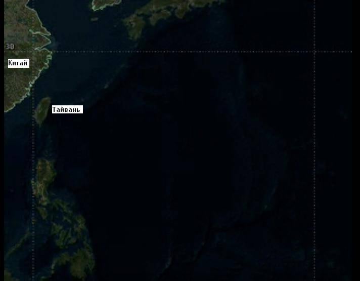
And in order to completely break your template (if there is one, of course), we will go on our ships to the place where the orbits of all Chinese reconnaissance satellite groups converge, to where, after the return of Hong Kong and Macau, all the attention of the Chinese Armed Forces is directed - to Taiwan. We will climb on slow ships into the very heat, where everything is viewed from orbit by several constellations of satellites, where over-the-horizon radars and RTR facilities operate, just so that you can see what these ships can even in our computer space time.
We'll go over here.
In this case, however, we will make some deviations from reality. Instead of simulating a real operation with a listing of all its stages and significant actions, which, generally speaking, is impossible within the framework of an article on the Internet, we will simulate actions to deceive enemy intelligence separately: first, we will analyze how to deceive space reconnaissance, then how to deceive radio engineering , ZGRLS, etc.
It will be easier, clearer and more accessible.
We deceive satellite intelligence
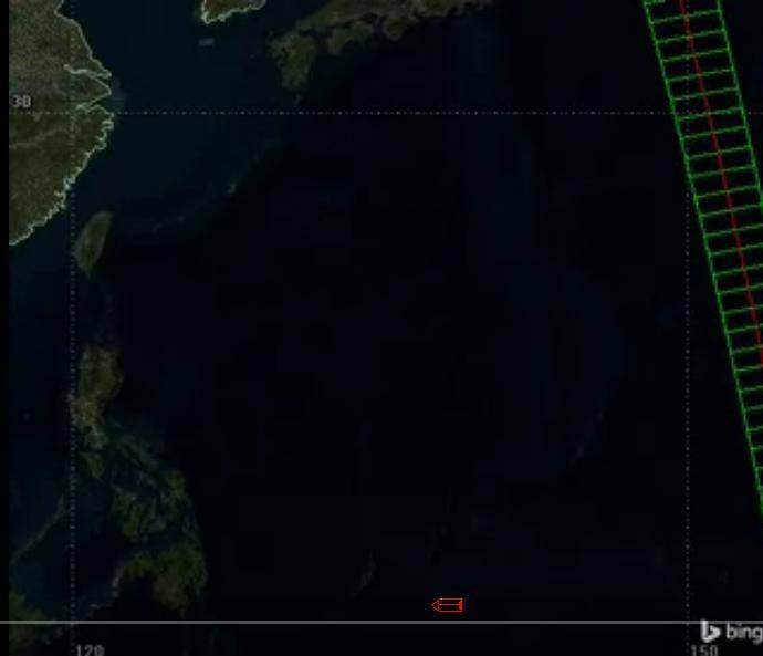
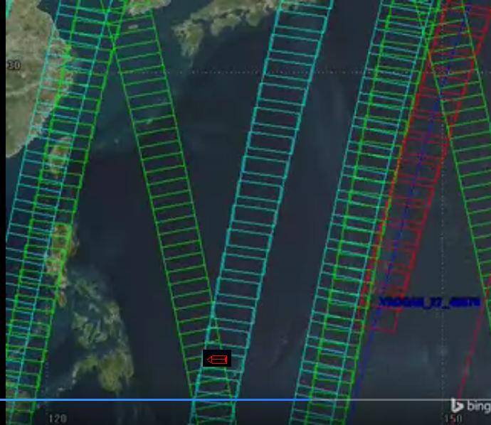
In order to show how the surface forces are deceiving satellite reconnaissance, we will conduct a simulation in "model" conditions, namely: the ocean is empty, it contains only our aircraft carrier group and nothing else, there is no traffic in which to hide, there are no cloud fronts, under which you can hide, no, there is nothing at all, the ships, in theory, will go like a fly under a magnifying glass.
But - a counter assumption for the attacker: the Chinese have only satellites and until they find the ships they will not raise reconnaissance aircraft. In fact, of course, this is not the case, but we need to find the limits of the capabilities of the satellite constellation, and such modeling is the best way.
Technically, detecting a ship from space is not a problem, it was done decades ago. And here, for example, a modern photo, and a Chinese one. This is precisely the American aircraft carrier group.
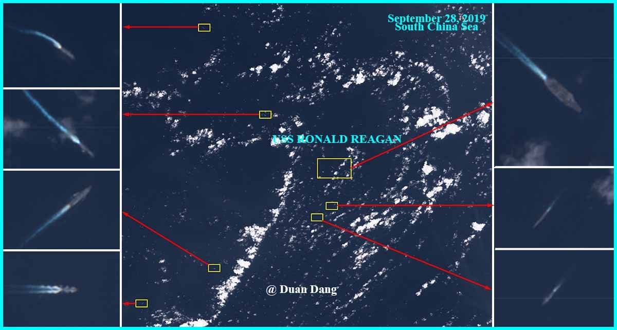
By the way, since we are talking about misinformation and misleading the enemy, please determine from the photo where (in which direction) this group is going. Put yourself in the shoes of an intelligence analyst. He, of course, has more data, but they are all like that. Reality is such a reality ...
We draw your attention to the fact that with a real number of satellites, the Chinese have no global continuous coverage even in their dreams: this is not Starlink, which is everywhere, the Chinese cannot deploy so many satellites to see everything, they have no money. The United States, by the way, has an intelligence network with a completely global continuous (keyword) online reach no money either.
This reservation must be made on purpose, since there are whole sects of would-be theoreticians who believe that instead of fleet you can launch satellites into orbit and, on guidance from them, launch rockets from the shore at all identified targets. It will not work, even without taking into account that the picture from orbit is not a control center. A satellite network with worldwide and continuous coverage, automatic classification of suspicious contacts, transferring them for identification to a live operator and automatic calculation of data for the use of long-range weapons even the entire “golden billion” will not be able to afford it from the coast. It is cheaper to build ten more "Nimitz" and raise air reconnaissance from them.
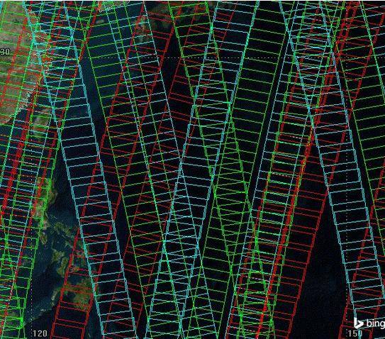
Now let's look at the Chinese satellite constellation in dynamics. Pressing THIS LINK, you can see a simulation of the passage of satellites over the area where we will go by ships and estimate the coverage and the speed with which the satellites pass the area designated for us for deployment. Be sure to click, since we will work with this particular simulation.
The area from which "we" will strike is controlled by the Chinese with the help of the following orbital groups:
1. A constellation of optical reconnaissance satellites, satellites Yaogan-15, 19, 22, 27. In the simulation, their coverage is highlighted in red. Only these satellites can help identify the ship due to high-quality radars, the rest simply see a radio-contrast target.
2. A constellation of radar reconnaissance satellites equipped with synthetic aperture radars, satellites Yaogang-10, 29. In the simulation, their coverage is highlighted in blue.
3. Another constellation of radar reconnaissance satellites, satellites Yaogang-18, 23, in the simulation their coverage is highlighted in green.
Broken satellites are not listed.
The actual size of the satellite coverage area may be different, and the overlap may be different than shown. But more on that later, other sizes and overlaps larger than in the simulation do not change anything, and this will be proven. In our simulation, the band captured by the satellite will be 300 km wide. Again, it doesn't matter.
So, at the maximum, all covered areas within 24 hours look like this.
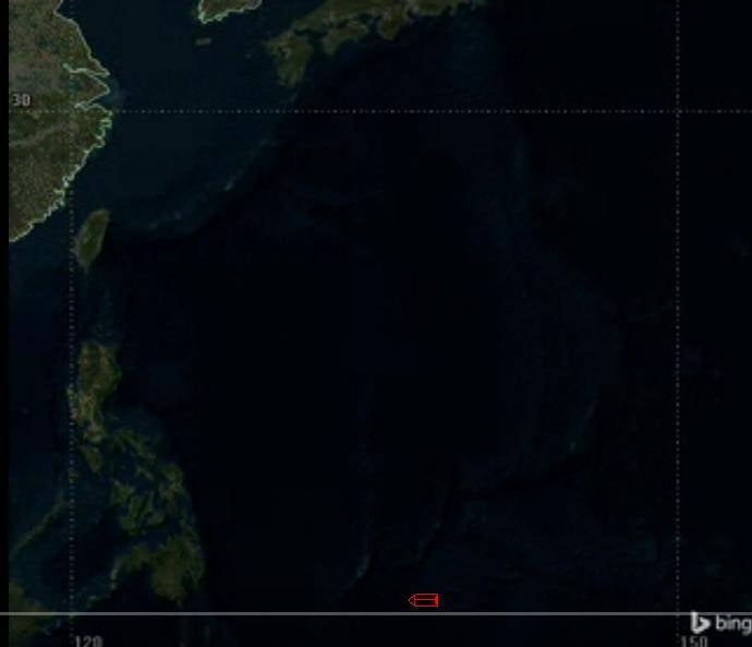
Impressive. It seems the ships have nothing to do here. But immediately we note the blind areas. They are.
These are dead zones, they are not visible from satellites. If the ship passes there, then you cannot see it from space.

Areas that are not visible from satellites in the simulation are highlighted in red with a "!" the area assigned to the aircraft carrier group for the start of hostilities against the PRC
But you have to get through somehow, right? However, small areas are too risky. We need to take a place in the big one, with small ones the reconnaissance could be mistaken, the satellites can really block them. Let's mark the zone where we need to go with the sign "!" It will strike at the territory of the PRC from it.
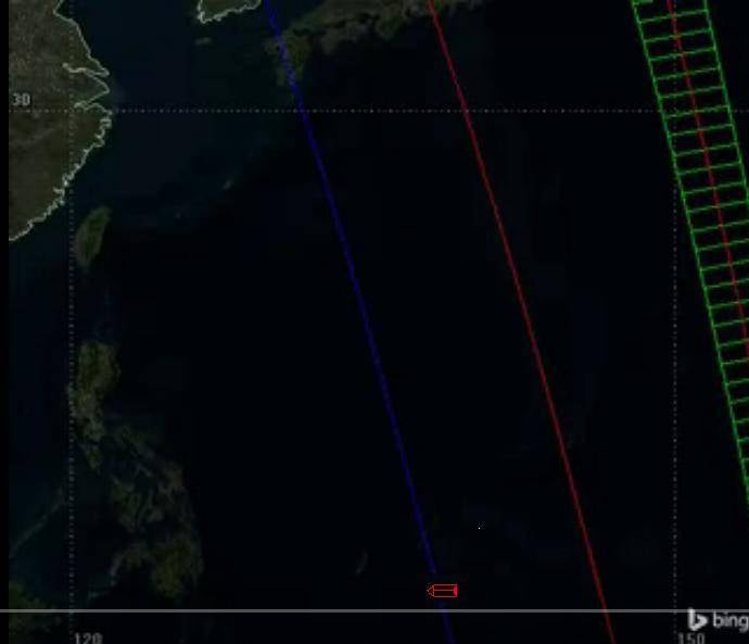
So, knowing the orbits and the time of flight of the Chinese satellites, we enter the area from the zone that is not visible by them due to the inclination of the orbits. This is how the coverage of the area looks by the end of the first hour of the operation - not a single satellite has flown over it since our appearance. We are waiting.
An hour passes ...
Red conventional sign of the aircraft carrier at the bottom of the screen, the escort is not shown conventionally.
Second…
Third…
Above us there is a clear sky, no one has found us yet. The group continues to maneuver in the designated area and waits.
The fourth hour is over. A satellite from constellation number 3 passes in the strip immediately adjacent to our waiting area.
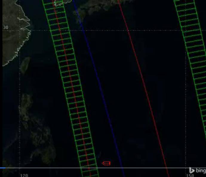
Now this band will not be controlled by anyone for a day. But we still have to wait.
The hours go by, the satellites are flying by ...
And now he is - the ninth hour behind, another satellite from another group slipped past - the one we were waiting for.
Now full speed ahead.
We exit at 28 knots and northwest. We have about 18 hours before the return flight of the Yaogang-29 satellite. During this time, we could have covered 958 kilometers. But we don't need that much.
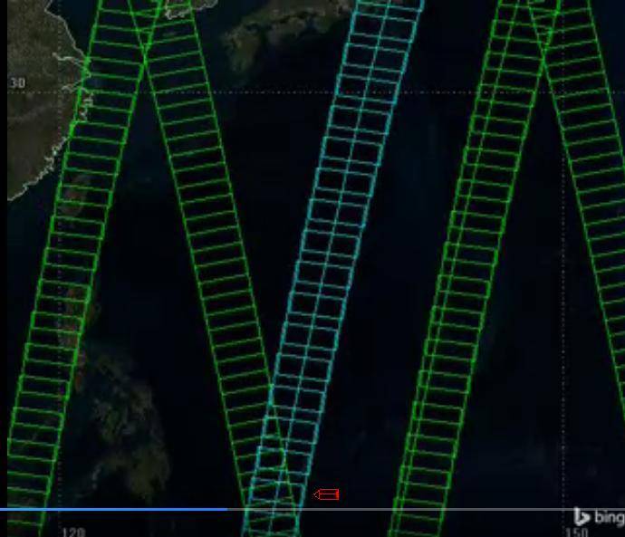
And now, after 6 hours and 30 minutes, we passed the zone over which two radar reconnaissance satellites have already flown by, and which no one is watching yet.
Ahead is another strip, over which a Chinese satellite will soon fly over, and from the most dangerous grouping. And so, at the end of the 20th hour of the operation, he flies over the area.
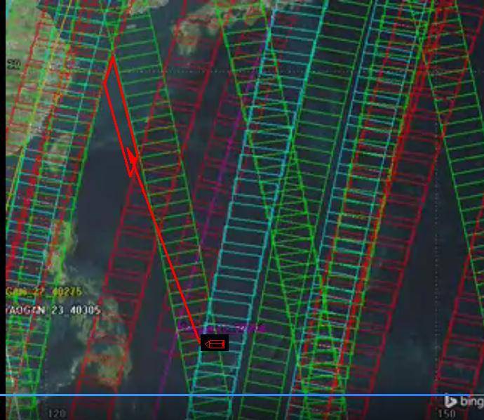
The arrow shows the path of the transition to the area that cannot be viewed from satellites. During the passage of satellite capture bands, there will be no satellites above them
Now again, full forward - we go to the north-west, into the blind zone. We have almost a day to get there, and during this day the aircraft carrier group will not fall under any satellite. When they make the next loop and again find themselves over the area, we will no longer be there. On the way, we will have to "skip" one more satellite, and this is not a problem.
52 hours have elapsed since the start of the operation, we went into an area not viewed by satellites, from where the planes normally reach the coast, over which no satellites are flying.
Moreover, the attentive reader will easily see other options for entering the designated area - faster and easier.
The distance from our AMG to the coast in the designated area is about 500 km, having planned a withdrawal after a series of attacks, the time, course and speed during which also correspond to the satellite flight schedule, we begin to raise the air group to strike. Meanwhile, ships with missile weapons prepare to launch cruise missiles at targets. We need an "alpha strike" - a blow with all our might, so that the Chinese will become really bad, and therefore everything that we have will be used.
Let's ask a question: what has the Chinese satellite reconnaissance seen and continues to see all this time in the empty ocean? The answer is that all this time she was watching this picture.

At the same time, the Chinese even have their own "Dagger" in our introduction - like this.
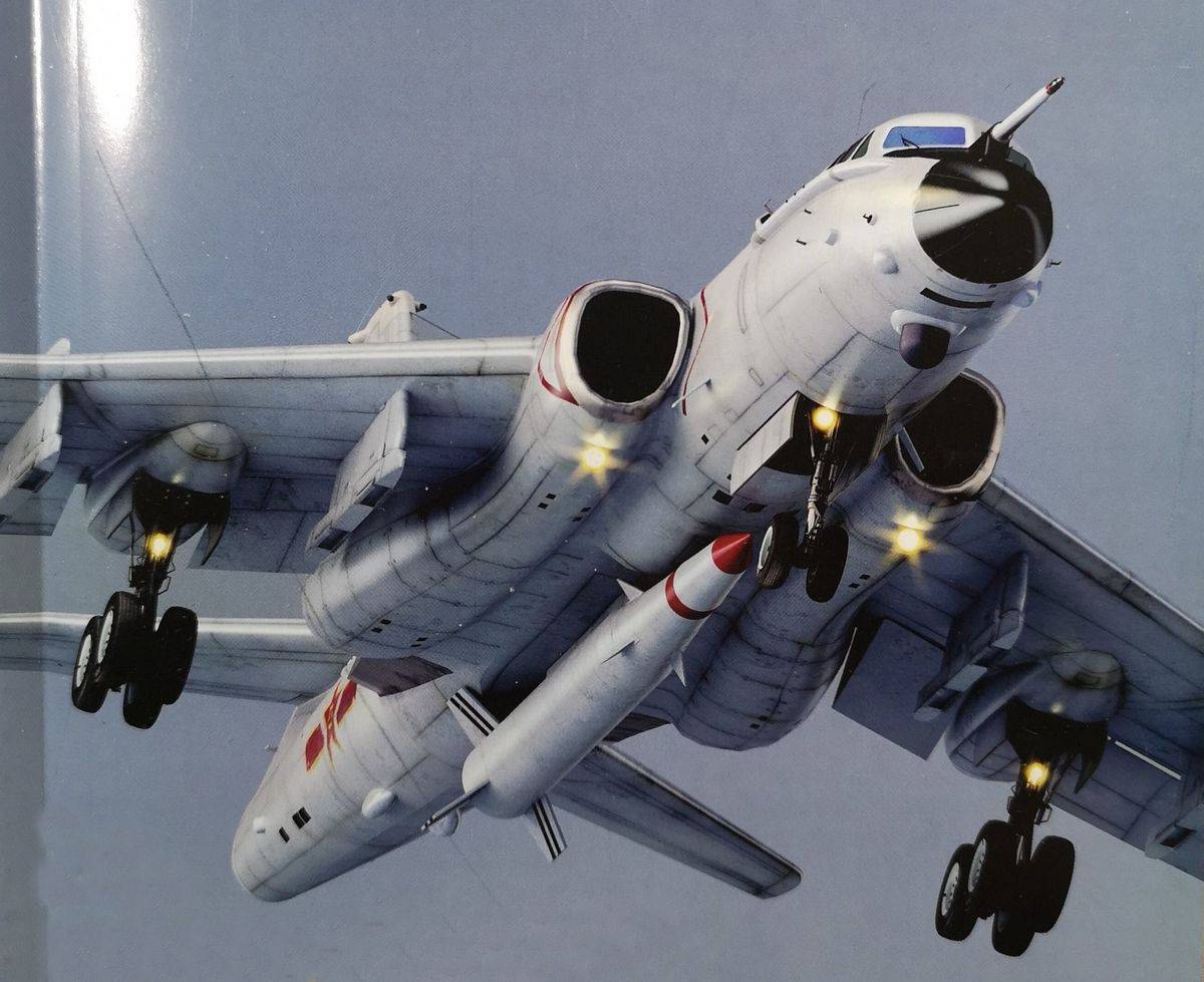
But they do not even suspect that there is a target for him, and so on until the airfield with these N-6 turns into a branch of hell.
Slow clumsy ships have done everything again.
If someone is jarring from the victory of the American aircraft carriers, no question, you can use the same methods to play back the Zircon strike from the Project 23350 frigates and the upgraded Project 1155 BODs at the San Diego and Kitsap naval base (Bangor-Bremerton). This is not fundamental, the deception of the satellite constellation is possible and will be carried out equally by everyone - but only if the attacking side is really ready to act this way, if it trained properly, learned to fight "in a real way," in Lenin's way. At the same time, the endless stupid maxims that we cannot create a larger fleet than the American one will disappear. We can't, yes. And it is not necessary.
Americans have shown us such things more than once in the past. Are they ready to act this way now is an open question, their IUDs are also undergoing a certain degradation, but they at least have such experience.
A bit of reality
What would affect the effectiveness of real satellite reconnaissance, and not our simulation? Capture band. It can be more than in the interactive diagram used above.
But it can be solved. The fact is that the data on the swath can be obtained even in peacetime. You can even use your own engineers and designers to reverse-engineer enemy satellites, how to develop them yourself, starting from the available intelligence. There is nothing special in this approach: the Americans did this, however, not with satellites, but with anti-ship missiles. During the Cold War, they collected more than 2 million fragments of Soviet anti-ship missiles from the seabed at the Pacific Fleet training grounds and, based on the results of their study and the available intelligence information about our missiles, they developed their homing systems so that later, understanding how our missiles are working, to create effective jamming complexes.
There is no reason why something like this could not be done with satellites: the enemy has no wreckage, but intelligence is there.
Cameras of the optical reconnaissance satellite "Gaofen-1", it did not get into the simulation, the orbit does not match. Knowing these angles of installation, understanding optics, knowing the height of the satellite's flight over the Earth, it is always possible to predict what width of the strip it can shoot
In addition, it is possible to provoke the defending side to various reconnaissance operations, appearing in different areas, about which it is necessary to understand whether the defender sees them or not, and from the time of the change in the nature of the radio exchange in his networks, from the reaction time of his forces and other signs to find out whether he sees his satellite intelligence are the forces that provoke him or not. All this is decided in advance, in peacetime.
The risks of error, of course, will never disappear, but such is the war. The chances that the satellites will be able to deceive in this way are great, and they repeatedly "bypassed" the Soviet "Legend".
What happens if satellite acquisition bands and overlap between different constellations leave no blind spots at all? Nothing much will change: knowing the time of flight of satellites of different constellations, the attacking side will maneuver between the capture lanes in such a way as to move from one strip to another immediately after the satellite's passage.
And this was done too.
What else is missing from the simulation? Clouds are not included. And this already works not for the defending side, but for the attacking one.
Any sailor knows that it is meteorologists who are the first to be included in the planning of any operation and are also the first to speak at the military council, because the weather is still decisive in the actions of the fleet, and in the actions of the aviation, the fleet - especially.
And when planning such raids, cloud fronts always matter. Clouds are still an obstacle for optical reconnaissance satellites. Shooting in ranges other than the visible range does not separately allow classifying targets, the same "Gorshkov" in many cases will simply be invisible when trying to detect it in the infrared range. This also applies mainly to modern western ships.
That is, cloud fronts remain a reliable shelter from some of the satellites - in our case, a third of the “paths” between which we were maneuvering to strike at China would “fly out” from the simulation.
Another problem is the Gaofen-4 satellite, which is not shown in the simulation, a geostationary optical reconnaissance satellite with a huge coverage area, "hanging" over Singapore. Its capabilities allow us to film the entire area in which we operate. It is assumed that its field of view is 400x400 km, and its resolution is 50 meters. Video filming is possible. In theory, a ship the size of an aircraft carrier can be detected with this satellite if the desired area is captured. But there are ways to divert attention to yourself by simply deploying the Evazi-AMG from a multipurpose landing craft and several smaller ships and "substituting" it for observation. Then the resources of this satellite, apparently, will be occupied. Plus the clouds, and you can take care of Gaofen-4, although nothing can be guaranteed, war is a risk.
All? In the case of China and the specified area, yes.
Absolutely not. In theory, an adversary like China could have radio intelligence satellites. Russia, for example, has them. And it is also necessary to “turn them off” from the search.
How to trick RTR satellites? The answer is what is well known in all fleets of all countries. What we have in the RF Armed Forces is called "Radio-technical camouflage"and the Americans have Emission control, EMCON.
And the same methods make it possible to deceive not only electronic intelligence satellites, but also RTR in general.
We bypass electronic intelligence, including satellites
Fast forward to the year when the Americans for the first time openly and without hiding, using the above (and not only) methods, clicked on the nose of the USSR Navy: 1982, autumn, NorPacFleetex Ops'82 exercises, in Russian: "Naval training operations" Pacific North 82 " ...
Recall that then, in the early 80s, America began to unwind the "cold war" and bring it to the pace that the USSR later could not stand, and naval pressure was the most important part of these efforts, and it was carried out during such "exercises" ...
In September 1982, the Americans, having substituted the Navy under the supervision of the AMG Enterprise, simultaneously secretly deployed the second AMG Midway and were able to hide this group from the intelligence of the Pacific Fleet on the transition from the naval base to the area of several hundred kilometers from Kamchatka. In the last days, before the main slap in the face, the Americans put Midway under surveillance in such a way as to make our intelligence feel that it was in fact the same Enterprise that we watched continuously. In the end, AMG Enterprise also broke away from observation, merged with AMG Midway, forming an aircraft carrier formation of a huge force and starting to practice a massive airstrike on Petropavlovsk-Kamchatsky - and only then they were found.
But after the discovery, the Americans again broke away from tracking, the departure of the naval missile-carrying aviation to designate the strike fell to nowhere, after which they calmly walked along the Kuriles to the south, using the aircraft carrier's ability to raise aircraft against the wind, invaded Soviet airspace when our interceptors could not take off because of the wind over the runway, and calmly went to the Tsugaru Strait to continue the festival near Primorye. There, of course, they were already expected.
More or less detailed events described by Rear Admiral V. Karev in the famous essay, those interested can assess what happened, but with two amendments: Karev, apparently, confuses the forces with which the Americans were met in the Sea of Japan, which is understandable (the case was long ago).
But what Karev "confuses", apparently deliberately, is how the air reconnaissance worked. In his essay, the scouts intercepted at night by the Phantoms from the Midway did not attach any importance to the type of aircraft (the Enterprise had only Tomkats), which in reality not simply could not have been, but it was not at all: the type of aircraft was a reconnaissance sign, for which aerial reconnaissance was hunting, and it was after the Americans showed our Phantoms, at the Pacific Fleet, that they realized that the Midway, which they could not find, was nearby. The Americans, by the way, confirm this.
But about aerial reconnaissance later, but for now - about radio-technical camouflage.
One of the participants in that operation, American carrier pilot Andy Pico, much later described these events from the American side in the article "How to hide an aircraft carrier." The original is in English, but there were enthusiasts on the Russian Internet who translated it. All text is here, the link to the original is in the same place, and we are interested in this fragment.
The main question is: how to hide the strike group at sea? The answer (in very general terms) is: don't tell your opponent where you are.
And this answer is not at all as ridiculous as it seems.
Let us illustrate the issue with the following example.
In the middle of the night, two football teams gather in the stadium, each on its own goal line. All substitutes on each team have guns, and all players on the field have pistols. All weapons used are equipped with a flashlight attached to the muzzle. The quarterback carries a warning light with him.
Now turn off the lights and plunge the stadium into complete darkness.
And who dares to light their flashlight first?
Now, to make the situation more naval, we will also move the audience from the stands to the field, distributing them more or less evenly. Above the field, we will hang two balloons, one for each team, equipped with signal lights and binoculars.
Obviously, in our model, light will play the role of both communication and detection means. The eyes of the participants play the role of RER, electronic support and electronic intelligence, as well as radars.
It is also obvious that if you want to remain unnoticed, then the best way is to move quietly and blend in with your surroundings.
...
The strike team moves to their theater of action in an atmosphere of complete radio silence. At the same time, the formation of the ships of the strike group is distributed over the area so that no system is able to identify the group simply by construction (in particular, for example, for example, why strict, dense structures, so beloved at parades, are never used in practice). For the strike group, wide-range search systems are especially dangerous, so that the enemy's reconnaissance means are blocked either by a complete lack of sensory information for them, or by disinformation, or by providing them with truthful information with some critical edits that completely distort the picture. For example, the enemy's RER means are guided by radiation detection. Therefore, the main way to avoid them is to radiate as little as possible.
...
On one stormy night, a man was washed overboard when the ships were operating just 200 nautical miles (approximately 360 km) from Soviet airfields in the Kuril Islands. Despite the takeoff of the rescue helicopters, an active search by several ships and voice transmissions in the UHF range, the entire successful rescue operation went completely unnoticed by the Russians, because at that moment all the Russian observation systems were over the horizon. Not a single satellite raised an alarm. The strike group proceeded unnoticed.
The strike team has reached its designated position, while the opponent did not even suspect that it was somewhere within a radius of two thousand miles from him. At this stage, limited air operations were undertaken in an environment of complete radio silence from the aircraft. Deck aircraft took off in complete silence and carried out operations, keeping below the radio horizon for the opponent's air defense, which were only 200 miles away. AWACS aircraft performed passive flights.
At the designated position, "mirror air strikes", that is, training strike missions aimed at 180 degrees from the real target, were carried out. And again, without any active means of communication. The entire cycle - takeoff, impact, return - was carried out during NORPAK 82 in complete radio silence. For four days, the planes delivered “mirror strikes” against Petropavlovsk and submarine bases in the Sea of Okhotsk, while remaining unnoticed. All day, every day AWACS planes patrolled in passive mode. All ships carried out intensive scanning by passive methods. In the event of a real conflict, the enemy, of course, would have guessed about the presence of the AUG after the first strike, as soon as he could get out from under the ruins of his bases and airfields. But this was an exercise, and the fleet continued to train in silence.
NORPAK 82 is an excellent example of a strike force camouflage in the ocean. During the exercise, the strike group operated for four days within reach of the opponent's strategic targets and remained unnoticed.
Currently, the ability of US Navy ships to operate in a completely passive mode, receiving tactical information from other sources, has been significantly improved. All ships and aircraft are united into a single network that allows the exchange of tactical information. If someone in the navy or space forces sees a target, everyone else sees it. With proper training and competence, a battleship can sail all six months (the duration of a standard campaign - approx. Transl.), Without turning on sensors and communications, and only listening to what others transmit.
...
As before, one of the main problems with finding a target is figuring out which of the surface contacts you have noticed is your target. Most passive methods involve the use of radars and target communication systems for this purpose, but they rely on the assumption that the target itself is emitting something. Do not emit anything, and the only way to identify you for the enemy is to get close to the distance of visual detection.
Let's recall the original model. Two football teams with pistols and flashlights on a darkened field, where their fans are also standing. Who dares to turn on the flashlight first?
The US Navy has the added benefit of networked communications; if someone in the US Navy (ships, aircraft, coastal bases and spacecraft) sees the target, then everyone else immediately receives the same information. That is, a combat unit can operate in an environment of complete radio silence and receive an idea of the situation from other units. This opens up a wide field for misinformation and setting traps.
If the opponent starts an active search using his own radars, then by doing so he gives out his location, declaring who he is and where he is to the whole region. Deck fighters can strike it without even turning on their own radars until the last moment.
Do not radiate, and RTR, RER and everyone else will not see you. I must say that our sailors perfectly mastered these methods and in the same way went to the distance of a missile salvo at the Americans in secret.
A little later, when we get to target designation, this issue will be considered in more detail, for now we will restrict ourselves to the statement that “walking without emitting” is not just something theoretically possible, it is something that has been repeatedly practiced in practice (successfully) and they , and we have. The Chinese seem to be working out too.
Thus, the RTR will simply have nothing to detect. Neither satellites (for example, our "Liana"), nor ground posts, nor RZK. The ship group does not radiate.
But, the inquisitive reader will ask, do coastal radars emit something? Go and see an aircraft carrier, and even with a group?
We cheat radar facilities
Another mythologized means are over-the-horizon radars (ZGRLS). The rushing brain of a man with an anchor in his head is looking for something to calm his psyche, something to believe that a magic system that allows you to find a target from a chair in a warm bunker and send an anti-ship ballistic missile (MiG- 31K with "Dagger", the mythical ultra-long-range version of "Caliber" ... write your own) can exist in the real world. To admit that the real world is complex and very dangerous, a person with a weak psyche cannot, he does not want to live in a complex and dangerous world and is trying to come up with a plausible fairy tale for himself. At a certain moment, ZGRLS become part of this fairy tale, which will immediately detect an enemy aircraft carrier (for some reason they never remember about cruisers and destroyers), as soon as it “appears” (the question of where it appears is no longer fit into the RAM of such a contingent) and that's when ...
A bit of realities.
ZGRLS operates on signal reflection from the ionosphere and, as a result, has an error in determining the coordinates and parameters (elements) of target movement. The greater the number of signal reflections from the ionosphere, the higher this error, and at a certain moment such a reconnaissance method simply loses its practical significance.
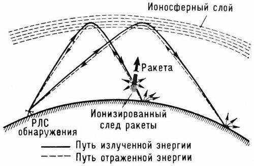
As a result, when working on surface targets, the ZGRLS data are of practical importance no further than 300-500 km. At the same time, one must understand that it is impossible to use weapons according to the data from these stations: they simply give an approximate target position and that's it.
Long-range skywave radars exist, but their target detection range is limited to a few hundred kilometers.
In line-of-sight mode, ZGRLS detects air targets, and quite accurately. It is also impossible to shoot at these data, but with the detection of air targets, everything is much easier than with surface targets. This is especially true for long-range radars that work ONLY against air targets, for example, the well-known radar type 29B6 "Container", capable of detecting and mainly capable of recognizing (for example, distinguishing a ballistic missile from an aircraft) aerial targets at great distances.
But we have a surface goal ...
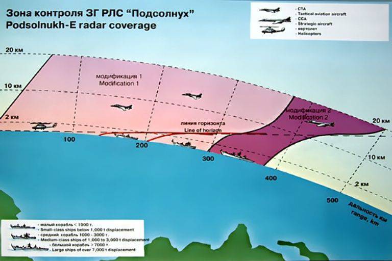
This is how Rosoboronexport portrays opportunities Radar "Sunflower"... This is an export option, the option for domestic aircraft is apparently better, but physics cannot be fooled, and it cannot be better at times.
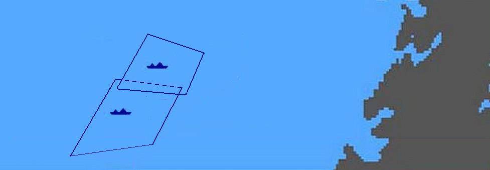
If we could visualize the difference between what information we would like to receive from the OGRLS, and what information the OGRLS actually gives us, then it would look like this.
This is what we dream about.
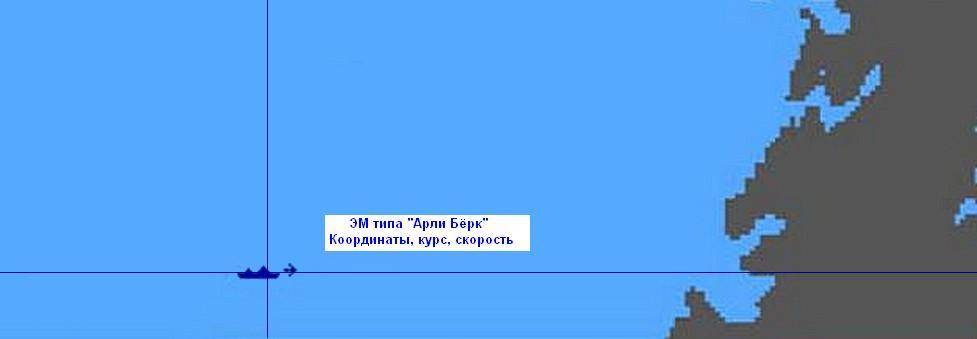
This is what you want: an accurate classification of the type of object, its course and speed in real time. And you can send some ultra-long-range anti-ship missiles to it, having calculated the data for firing before that
But this, in the first approximation, we actually have: the ship is somewhere inside the quadrangle, neither its type, nor its course, nor its speed are determined.
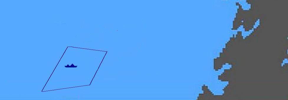
Large surface contact, type, course, speed unknown, exact coordinates too
Moreover, the very area where the target is located, in reality, is not at all a quadrangle, it is rather a spot on the map, and the position of the ship inside this spot is estimated by the theory of probability. Accurate visualization would be something like this.

Aircraft carrier Rorschach. Boundaries of the "spot" - an area outside of which the probability of finding the observed radar target is negligible. Inside the "mark" is different from negligible, the color gradient symbolizes the probability distribution of the object being inside the mark, the linear dimensions of the "mark" are measured in the lengths of the target or tens of its lengths. But this is all inaccurate. Other information cannot be obtained from the mark on the OGRLS screen
It is this kind of information that can be pulled out of the mark on the ZGRLS screen, and nothing else. Over time, it will become clear where the target has been moving all this time, by the displacement of the mark, but it is impossible to use weapons on such signals.
Further we, of course, will operate with frames, so as not to complicate. What if there are multiple goals? Then our blotted frames are superimposed on each other.
Now we still admit, at least for sure, albeit inaccurately, but the ZGRLS target - the aircraft carrier group - will be discovered. Provided that it comes closer than 500 km to the antennas. And if not?
The second point is the following: even if the AMG comes close, then in the real world there will be a lot of frames on the ZGRLS screen.
This is what the traffic looks like in the area from where "our" AMG struck China.
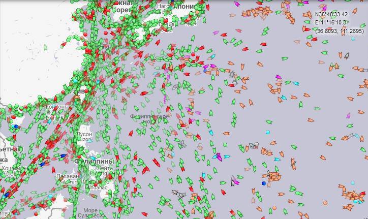
And the coordinates of each "target" ZGRLS will give us with an error. That is, there will be a "frame" around each contact. In addition, this image only shows vessels that have an AIS terminal enabled. It is widely known that, for example, fishermen turn it off during fishing, so as not to "shine" the fishing spots. Tankers with Venezuelan oil, North Korean bulk carriers, smugglers and many others also go without AIS. So there will actually be more goals.
In turn, the enemy's warships may have a fake AIS terminal, which is turned on or off according to the situation, and the enemy's cyber command can simply “put” the AIS at the stage of the operation: remember that the whole naval command is engaged in cyber warfare in the US Navy - 10th Navy Fleet. Confusing the defender in such a situation can be very serious.
Outside of communication with the AIS, if suddenly the attacking side needs to enter the zone where the coastal radars will detect it in order to carry out a combat mission, you can go "from the opposite". You can pre-enter a dozen small auxiliary vessels into the area, which, on command, will simply set false targets or fields of false targets - inflatable corner reflectors, and will even tow these fields, creating the appearance of an aircraft carrier and its escort.
As a result, in conditions where it is impossible to avoid the detection of an aircraft carrier group using over-the-horizon radar, one can instead create the impression on the attacked side that everything is simply teeming with aircraft carriers. He will see on the screens dozens of aircraft carrier groups moving in different directions, and satellite reconnaissance and RTR will show that there is nothing. Contacts can be "inflated" and forty pieces.
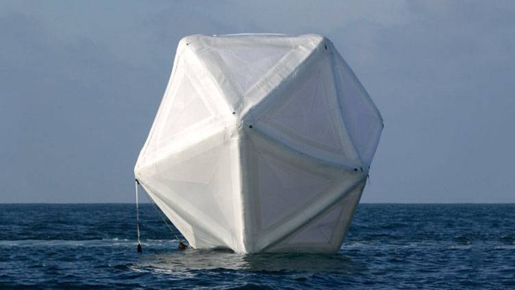
Inflatable corner reflector. They can be displayed individually or in "fields", mounted on floating craft, including unmanned vehicles, towed, etc.
And then there are the means of electronic warfare - electronic warfare, which significantly complicate the detection of targets and their classification and may be outside the battle formations of the advancing aircraft carrier group.
In such conditions, the defending side has no other option but to check each "contact" by aerial reconnaissance, or, if there are still suspicions that the enemy is preparing an attack from outside the ZGRLS operation zone, to weed huge areas with aerial reconnaissance - at random, without prior detection of the enemy by other means.
But aerial reconnaissance can also be fooled.
We deceive aerial reconnaissance
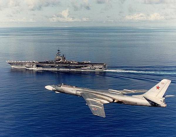
During the aforementioned raid of American aircraft carriers on Kamchatka in 82, aerial reconnaissance was working and the American aircraft carrier group was being discovered. But then she lost again.
Cold War air reconnaissance
A word to the participants in the operation from our side (can be compared with what Karev wrote and draw some conclusions):
On September 12, 1982, the 219th separate long-range reconnaissance aviation regiment of Tu-16R reconnaissance aircraft was alerted. Flight personnel at the control tower, in the pre-flight training class. The regiment commander, Colonel Vladimir Filippovich Bychkov, brings the situation and sets the task:
- According to the intelligence of the Pacific Fleet in the San Diego area, off the west coast of the United States, the formed aircraft carrier group led by the aircraft carrier Enterprise passed a covert southern route along an arc of a great circle and is deployed in a northwest direction in the Kamchatka and Kuril Islands. The second carrier group "Midway" on September 9 left the Yokosuka base (Japan) and secretly moves to the formation area of the aircraft carrier formation "Enterprise" - "Midway". From September 11 to the present, there is no information on the whereabouts of aircraft carriers. They move across the Pacific Ocean in radio silence, with the ship's radar stations turned off, hiding behind civilian ships. Therefore, the main burden of searching for ships falls on the navigator staff and radio intelligence operators.
...
Each of the crew was slightly anxious: could they immediately find a sea target - an aircraft carrier, without knowing the exact square in the search area of about 3000 square meters. km, clogged with civil, fishing and other vessels?
...
We walked half the way in complete silence. Suddenly - the report of the second navigator that he is observing large flares on a radar sight, similar to a group of ships. The slave also sees flares, but only to the northeast. The commander asks the operator what is on his screen. The answer disappoints everyone: the monitor screen is clear, there is no radiation from the ship's radars at the known frequencies of aircraft carriers. Right pilot Yuri Nikityuk left the slave on external communications to transmit the request of the crew commander Shkanov to change the echelon to visually determine the target. Two scouts go down under the clouds, the height is 5000 meters, there is flare, but there are no ships. A decision is made - to walk in zigzags, to cover as much of the search territory as possible. Found more highlights, but the ocean is empty.
It becomes clear: we were led away, throwing the bait in the form of dipole reflectors, knocked out of the way and forced to burn fuel in vain. We must understand: either the Americans are deliberately laying out a path for us to a sacrificial target - an aircraft carrier covering another aircraft carrier, which will carry out a massive attack on military targets located in the Far Eastern territories without interference. Or do they still disguise themselves and purposefully lead the scouts aside until the fuel is completely depleted? The ocean is huge, and there is nowhere to land. The aircraft commander asks the operator to look for the ship's radar. I understand that the ship station should turn on, but only when it smells of fried. A radio operator came to the commander with information from the command post that today, on September 12, a pair of Tu-16R scouts of the Pacific Fleet aviation were intercepted by "phantoms" based on the aircraft carrier "Midway", which for some unknown reason could not be found.
"Will anyone bring me good news today?" - exclaimed the commander.
The radio intelligence operator reports that he sees the exact direction of the radar radiation. Data analysis confirmed the frequency, pulse length, configuration and operating range of the aircraft carrier Midway's early warning ship station. After two minutes of operation, the station turned off, but that was enough: along the course, on the right, 20 degrees, at a distance of 300 kilometers, there was a Midway. To the right of 35-40 degrees on the screen in the same direction, another light flashed. Was it an accident or not? After five seconds it disappeared, it was not possible to analyze the frequency spectrum. The mark did not appear again. Interception by fighters is possible, they just do not include the ship detection station. The fighter's radar warning system is suddenly triggered. The commander of the firing installations observes the approach of the phantoms.
- All the same they got us, - the commander said with annoyance, - and most importantly, from where they did not expect.
He was worried by the thought that the operator was mistaken and was taking a couple of scouts to a false beacon emitting the frequencies of the aircraft carrier station. In the meantime, the "phantoms" were attached a few meters away. The American pilots, through a gleaming blister, were smiling and beckoning to follow them. Then they soared up sharply and with a right turn left to the south, from where they came. The navigator immediately offered to follow them, they would definitely lead them to the aircraft carrier.
Commander:
- Anything can be. Phantoms are based only on Midway, intercepting scouts 200 kilometers away is a normal technique to distract from the aircraft carrier, leading them in the opposite direction.
As a result, the Midway was found, and those who are not lazy to follow the links will be able to see photos of this ship taken by Soviet planes.
But the trouble is, they found it late, after the Americans had “bombed” Kamchatka, and more than once, and secondly, then they lost it again, like the Enterprise.
This episode gives a good idea of how difficult it is to look for a surface target at sea, even when it is a little over 300 kilometers from the main air force bases of the USSR superpower in the region.
And here is the American view (Pico):
We can also deliberately supply our opponent with fake contacts. For example, if a patrol plane is intercepted by our carrier-based fighter, then the opponent can roughly estimate the range of the interceptor and concentrate his efforts to find the aircraft carrier around this point. But nothing prevents us from deliberately intercepting any search aircraft at a distance significantly exceeding the normal range of an interceptor - using air refueling, for example - while at the same time directing the aircraft carrier at full speed in the opposite direction. Then the search efforts of the enemy will be concentrated in the wrong area. I once did this trick on an A-7 Corsair II, refueling in the air and approaching at low altitude a pair of Tu-95s, which visually identified sea traffic. I entered them from a direction that did not correspond to the direction of the aircraft carrier, and left in it. Midway at this time at all its 32,5 nodes retreated in the opposite direction. A few hours later, a whole flock of patrol planes searched the interception area in vain, surprising the fishermen who were there.
There are actually a lot of such examples. And the keywords that are given in the article about our pilots, who then, in 1982, were looking for "Midway" are:
“The fighter's radar warning system is suddenly triggered. The firing commander observes the Phantoms approach.
- All the same they got us, - the commander said with annoyance, - and most importantly, from where they did not expect.
- All the same they got us, - the commander said with annoyance, - and most importantly, from where they did not expect.
They are key because the USSR and the USA were not in a state of open, “hot” war.
What if the Americans wanted to open hostilities? The reconnaissance would simply be shot down, that's all. Because peacetime operations are one thing, and war is quite another.
War Amendment
Both we and the Americans are accustomed to playing such games for many decades of confrontation. Now the Chinese are getting used to it.
And these cat-and-mouse games with little or no real shooting lead to some patterns in the mind.
For example, in the above example, Tu-16s flew out for reconnaissance without fighter cover.
In the event of war, everything changes. ZGRLS are destroyed by cruise missiles from submarines and bombers even before the deployment of naval forces, satellites in low orbits can go astray, and aerial reconnaissance will have to face a very unpleasant problem.
In order to detect enemy ships not directly under the coast, after they have completed their tasks, but in advance, at a safe distance, you need to survey huge spaces. And this requires a lot of airplanes. You need as many of them as you never will.
This problem was faced in full growth by American and Japanese carrier-based aircraft in World War II: IT DOES NOT COVER. It was necessary to determine the most dangerous directions and conduct reconnaissance along them. The Americans in the Navy used the term - threat vector, a threatening direction. Often, he was simply appointed by the commander of the formation based on his ideas about the situation. Or even intuitively. Sometimes it turned out that they had not guessed, so, for example, the Japanese did not guess at Midway.
Basic aviation will also have this problem. An exception is if it is possible to attract unrealistically large forces for reconnaissance.
But let's say we have an unrealistically huge reconnaissance force, for example, two regiments of reconnaissance aircraft, which we send in pairs to search. And there are airfields, and refueling.
Then, taking into account the involved huge detachment of forces, we are guaranteed to find an enemy in the area that was discussed at the beginning of the article. We will find, in spite of all the false targets, in spite of the interference and all the tricks.
But this is the specificity of the war itself - with the maximum degree of probability, that pair of scouts who stumble upon him will simply die, and instead of accurate data on the position of the enemy, we will again get an approximate area where he may be.
And if the enemy ensures the destruction of several pairs of scouts with his interceptors, then it will be necessary to weed out several areas - and not forget about the other tasks.
And this is all the time. Until the enemy is detected, until constant contact with him is established in one way or another, time works for him. You can raise an air regiment from the shore to strike without having accurate data about the target, and having only approximate, and scouts - for its additional reconnaissance, with the expectation of an attack immediately after re-detection, which they will have to provide ... but what if the target is still not there? In addition, such actions sharply increase the risks of simply being ambushed.
A word to the already mentioned Andy Pico:
A few words about your opponent. The Soviet naval missile-carrying aviation was (and remains) very well organized and well armed. Attack air regiments Tu-16 or Tu-22, supported by Tu-95 and naval reconnaissance patrol aircraft, were a dangerous enemy. The USSR had approximately one MRA air regiment for every American aircraft carrier. If the MPA regiment took the aircraft carrier by surprise, all that remained was to lower the curtain. The aircraft carrier, warned in good time, had a good chance of survival, but with the risk of significant losses and damage. But the MPA regiment, pushing through the curtain of fighters back and forth, inevitably suffered heavy losses. It would not have enough combat-ready aircraft left for a second strike - if it had remained at all. If the rocket trap was placed on the way in such a way that the air regiment would begin to climb to the launch altitude within the reach of the missile-carrying ship, which the pilots would not know about exactly until the moment when the guidance radar would turn on and the missiles would start to explode, the battle would end before it started. Therefore, the key to striking was the requirement to identify the target and determine its exact position before the air regiment rises to strike. And this gave the aircraft carrier time to take action: maneuvering, placing distraction groups, rocket traps, ambushes of fighters, etc.
With, say, a two-hour warning, an aircraft carrier could:
- direct the missile-carrying ship as a missile trap 60 miles down the vector of the most probable enemy approach;
- to place air patrols on the defense perimeter;
- place one more missile-carrying ship in its previous position as a decoy target;
- Move 60 miles in any direction in radio silent mode.
In this case (under optimal circumstances) The air regiment that flew into the attack would confirm the presence of a target near the expected point, would fall into a rocket trap, then under an attack by fighters, and as a result would find out that the target found was not an aircraft carrier at all, but quite capable of holding up a cruiser or destroyer.
In theory, MPA attacks were to be carried out with fighter cover, and many different options were worked out to use fighters in such attacks. But in reality, apparently, with fighters would not be "wondered", especially when hitting a long range, beyond their combat radius ...
So even aerial reconnaissance did not give any guaranteed results, it will not give them even today. And, of course, neither we, nor the Chinese, nor anyone else will ever have two reconnaissance regiments for one carrier group. This is simply impossible, which means that the work of the attacking side will be much easier than described above.
This is how it all looks in reality.
Conclusion
The idea that ships are in the sea at a glance and that they cannot hide does not withstand a collision with reality. Satellites, electronic, radio engineering and aerial reconnaissance do not give a 100% guarantee that a surface ship or a group of surface ships entering the line from which the strike will be struck will be detected.
And even if they are found, then for a time sufficient for their destruction.
To shoot at a target, you need to see it, this does not require proof. This article shows how difficult it is.
And, of course, no miracle weapon from the world of fairy-tale fantasies simply cannot exist. There is no and never will be a system that would allow, in a short time, measured in minutes, to detect a surface target, for example, 1000 kilometers away, strike and strike at it. No anti-ship ballistic missiles, "Daggers" and other close-sight combat fiction will help if the target is not detected and tracked before the strike (with recalculation of the data for firing / updating the CO) and at the time of application.
All of the above should not be understood as the invulnerability of ships at sea. It's just an indicator of the complexity of the task of finding and destroying them. Detecting enemy ships at sea is an incredibly difficult task, requiring large naval forces, including aviation, tremendous efforts, high professionalism of personnel, and, most importantly, preparedness for losses.
Operations to detect warships, if the enemy is competent and knows what he is doing, are not just very difficult. In a real war, they will also be very bloody.
In the old days, when we had air reconnaissance, air refueling and strike forces, the search for an aircraft carrier and the execution of a conditional attack by the MPA or fleets in general were carried out in such hellish conditions as indicated above. The fact that our people very often succeeded in putting the Americans in their place is a huge achievement by any measure. Today, the Americans are much worse prepared than in the 80s, then in general there was a peak of their combat effectiveness as a nation, and this also concerned the Navy. Today they are far from themselves as they were then, but at least they have a much more advanced technique. And there are still many more. We are mainly focused on propaganda, and not on achieving real combat readiness of at least the available forces ...
The next article will reveal another important issue: target designation for a detected target. Many do not understand the meaning of this concept and think that if more or less exact coordinates of the target are known, then a weapon can be used on it.
This myth also needs to be done away with.
To be continued ...
Information