Farewell to GPS. Americans are looking for an alternative to satellite navigation

147
Farewell to GPS. Americans are looking for an alternative to satellite navigation

The global GPS system has become vulnerable. Source: popularmechanics.com

Expensive and unsafe


Why is the famous GPS not happy with the US military? First of all, the high cost: each new satellite costs $ 223 million. This has already become the reason for the reduction in purchases from the Pentagon in recent years. The second, more serious problem is the vulnerability of the satellite constellation to the threat of a new weapons Russia. In April of this year, the US military accused the Russian Aerospace Forces of testing an A-235 Nudol anti-satellite missile, allegedly aimed against US space objects. According to the Pentagon, individual satellites of the Keyhole / Chrystal reconnaissance group, which previously (in February) "probed" the Russian spacecraft Kosmos-2542 and Kosmos-2543, acted as a potential target. The head of the US Army's Space Command, John Raymond, commented on the situation as follows:

"Russia's DA-ASAT (direct-ascent anti-satellite weapon) test shows yet another example that the threats to US space systems and [their] allies are real, serious and growing."


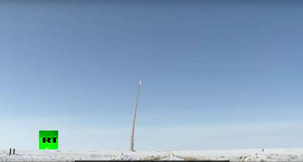
Tests of the A-235 "Nudol" rocket capable of shooting down satellites. Source: rt.ru

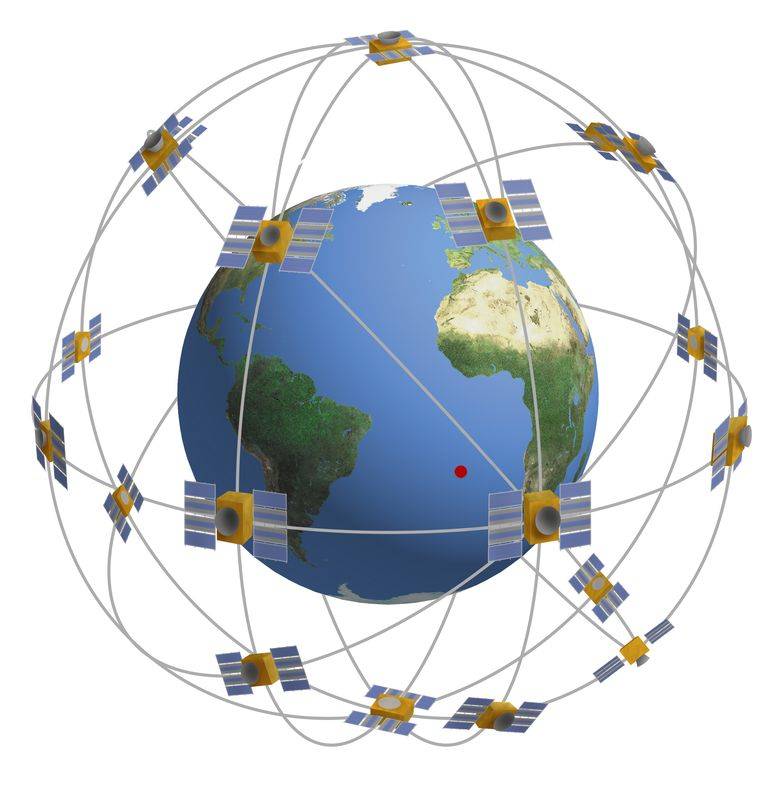
All this clearly makes it clear to the American military that in the event of a conflict with Russia, a space constellation of satellites may be under attack, and GPS devices will not be the last on the list of targets. This creates global problems for the United States' favorite remote warfare, when most of the strikes are carried out not within the line of sight, but on signals from the global positioning system. And this is not only a matter of Russia's anti-satellite weapons. Last year, the Americans allegedly already caught domestic electronic warfare equipment in violation of the GPS over the Mediterranean Sea. According to the Pentagon, this was carried out to cover the group of Russian troops in Syria. Some powerful sources of interference for global positioning systems were deployed in Khmeimim, which “manipulated” the signals of GPS satellites even at the airports of Ben Gurion (Israel) and Larnaca (Cyprus). The special services and the Russian army are accused by the West of at least 10 thousand registered cases of so-called spoofing of GPS users. Receivers of a satellite navigation signal receive data from a third party, which displays coordinates that do not correspond to reality to the user. A very useful competence in the era of precision weapons, I must say. In particular, information circulates in the American press that in 2018, during the grand opening of the Kerch Bridge, a convoy of trucks led by Vladimir Putin was actually in the area of ​​Anapa airport at a distance of 65 km. At least according to the GPS system. To what extent this corresponds to reality is unknown, but one can only be glad for the impressions of Russia's potential opponents. For the sake of fairness, we note that GPS jamming technologies have been developed to one degree or another in China and even in North Korea.

The US military has been looking for a replacement for the GPS system for several years, and navigation with the help of an atomic clock could become one of the first alternatives. In 2012, prototypes of C-SCAN atomic clock chips were created at DARPA, which, together with an inertial navigation system, make it possible to accurately determine the location of individual fighters, equipment and direct precision weapons. Moreover, the measurement error in the new system is much lower than in the case of satellite navigation. In principle, even now, the US military uses gyroscopes and accelerometers in case of GPS malfunctions, and atomic clock chips will allow all this to be miniaturized. And no interference, no third parties in the form of the Russian special services. But until these undertakings are implemented in real devices, the Pentagon has only to dream of navigating on new principles. For example, astronomical navigation with a sextant in hand was recently returned to the training program for naval officers. These are, of course, extremes that have no relation to reality and force us to look for alternatives. For example, take into account the peculiarity of the terrain magnetic field in navigation.

With a magnet in hand


Using the Earth's surface magnetic field gradient for navigation is not American know-how. Articles on similar topics have been circulating in domestic specialized scientific publications for several decades. And the idea itself was expressed back in the 1960s by the Soviet academician A.A. Krasovsky. The technologies being developed now are based on modern magnetometers, which have very high sensitivity, accuracy and speed. Considering the high variability of the Earth's magnetic field, we can confidently speak about the possibility of orientation based on an individual signature of a terrain or region. An airplane, rocket or tank equipped with sensitive magnetometers and accurate magnetic maps of the world will be able to navigate without involving a GPS system. At the same time, the positioning accuracy can reach 10 meters, which is not fundamentally different from satellite navigation. The parameters of the magnetic field gradient are independent of solar activity, season and weather conditions. But in theory it turns out so beautifully. If the Americans decide to create such a system (it already has a name: MAGNAV) for their army, they will face a lot of problems.


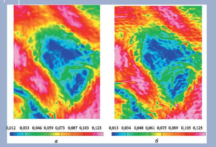
Comparison of the magnetic gradient of the terrain. 2011 on the left, 1999 on the right. Source: Journal "Problems of Management"

Firstly, to wage war on enemy territory, it is necessary to have accurate maps of the magnetic field of the area. But how to do it? It will not work from the satellite, the height is too high, the gradient will simply not be visible. A certain solution may be the hidden installation of magnetometers and recording equipment on the planes of regular flights of foreign airlines. But if you look at any online map of air traffic, for example, Russia, you will understand the futility of this. We have vast territories over which no air routes pass. And the flight altitudes of civilian ships are still very high, which does not allow studying all the subtleties of the magnetic gradient. And the Pentagon needs magnetic maps of the terrain primarily for navigation of cruise missiles, which go to targets several tens of meters above the surface. In Russian publications it is mentioned that aircraft cannot climb above 1 km for normal navigation along the magnetic gradient. In the United States, a combined navigation system is being considered for this situation, when the vehicle moves along a magnetic gradient across the previously explored territory, and when it passes the "front line" it turns on the inertial system. It turns out inaccurate, but there are no other options yet.

Secondly, magnetometers are constantly interfered with by parasitic fields, that is, drowning noise. Especially a lot of it is generated from the aircraft itself. What about the magnetic field created by the helicopter rotor? The Americans are trying to solve the problem of removing noise using artificial intelligence algorithms: they are currently working on this topic at the Massachusetts Institute of Technology.


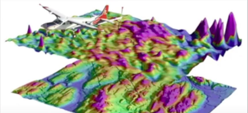
American experiments on building a magnetic map of the area using magnetometers installed on the light aircraft "Cessna". Source: defenseone.com

Thirdly, during intense hostilities, there will inevitably be explosions, gun salvos and other harmful magnetic impulses that interfere with the operation of magnetometers. And what will happen to such navigation after a series of atomic explosions? In general, the resistance of the novelty to war conditions is still questionable. For strikes against banana republics it will do, but I think there will be nothing to jam the GPS with.

Any action will inevitably be opposed. One of the forms of such "anti-navigation" work can be powerful sources of a magnetic field, dispersed over the territory of a probable clash. The purpose of this technique should be the formation of magnetic terrain gradients that distort the real position. And then the probable enemy will have to rely on the good old inertial system, or even on the sextant.
147 comments
Information
Dear reader, to leave comments on the publication, you must sign in.
  1. +4
    20 August 2020 04: 25
    Everything for the war, someday it will happen.
    1. +5
      20 August 2020 07: 26
      Quote: Pessimist22
      Everything for the war, someday it will happen.

      Pessimist, everything for a woman with a scythe. She will still come / wassat

      Open your eyes. Summer. Warmly. Birds are singing. Kids are playing. Life is now.

      And you pretended to be God - you make plans.
      Although more like the devil. After all, you wish us war.

      Okts.
      1. 0
        20 August 2020 15: 43
        everything repeats itself, Temples in 41 also did not believe, 27 million, but they could have lived, now there will be more
    2. 0
      20 August 2020 10: 25
      She has been walking for a long time, you just have to appear at her (even a stuffed animal, even a carcass).
  2. -21
    20 August 2020 04: 47
    Before you write about something, you need to know something about it. Navigators have no connection to satellites. Communication goes through cell towers. Satellites are transmitters of very precise time, up to a millionth of a second. Distances from the receiver to the satellites are different. The terrain maps are already in the receivers and are being updated. By calculating the time difference between the received signals from different satellites, the receiver determines its location, the speed of radio waves is 300000 km / s, then simple mathematics. The navigation system itself is not able to determine the location of the receiver, otherwise the same Malaysian Boeing would have been found long ago. The author himself invented, wrote and admired himself.
    1. +37
      20 August 2020 06: 17
      Not necessarily communication towers
      The satellite broadcasts three main types of information - the time on the satellite for calculating the position, the parameters of the orbits of all satellites in the almanac system, and the satellite's own ephemeris with updated data on the orbit of a particular satellite.
      The receiver, when turned on, first receives an almanac from any satellites, and then determines the location by distance to specific ones.
      Towers help download data faster, but this is not required.
    2. +8
      20 August 2020 06: 51
      Well, how come they have no connection with satellites? How do they get the time? And how do the receivers understand from which satellite they got the time? Communication is just unidirectional, but it is wink
      1. +4
        20 August 2020 08: 07
        The word communication is usually understood as a two-way transfer of information.
        Despite the fact that satellite navigation has existed for a long time, you can still see the idea that the navigator asks for the satellite, and that sends the location in response. I don’t know where this misconception came from, but it is not uncommon.
        Interestingly, now at school they don't tell physics how it works?
        1. +3
          20 August 2020 09: 09
          In a few years my children will go to school, so I’ll find out what they teach there)) but as a signalman I can tell you that communication can be one- and two-way. Just don't be confused with simplex and duplex wink
          1. +9
            20 August 2020 10: 18
            I know.
            But in the everyday sense, a person listening to music on the radio or watching a program on television usually does not say that he has established a connection with a broadcasting radio station or television center.
            1. +2
              20 August 2020 19: 23
              Unlike them, we are professionals wink
        2. -4
          20 August 2020 10: 14
          In cruise missiles, a directional antenna. And from the jammers on the ground, they are neither cold nor hotBut satellite hunters are a real threat. As for the inertial navigation system, this is the future. No satellites. the accuracy is now better than gps, only as long as the road is not reliable due to low temperatures. It will take 5 years to bring to mind
          1. -1
            20 August 2020 12: 38
            Quote: imobile2008
            And from the jammers on the ground, they are neither cold nor hot.

            In fact, the Soviet electronic warfare and signal troops were already armed with balloons and probes, which rose to heights of the order of several kilometers or even higher, and which could crush GPS signals over vast territories. So, thirty years ago, there were already ways to suppress the GPS system and the Americans were well aware of this. And now they know, but apparently the time has come for a new cut of budget money for such systems, so they started throwing in what they knew about a long time ago.
        3. +2
          20 August 2020 11: 27
          The word communication is usually understood as a two-way transfer of information.
          Despite the fact that satellite navigation has existed for a long time, you can still see the idea that the navigator asks for the satellite, and that sends the location in response. I don’t know where this misconception came from, but it is not uncommon.
          Interestingly, now at school they don't tell physics how it works?

          The navigator doesn't even ask for a satellite. It's just a signal receiver. Having received signals from at least 3 satellites, he determines his own position through trigonometry.
          The more satellites he caught and the farther they are from each other (the greater the angles between them), the more accurate the definition.
          Self-direction finder.

          This is if a real navigator.

          What is in a smartphone is a pseudo navigator, communication via the Internet and mobile communications.
          No internet and no mobile - no navigation.
          1. 0
            20 August 2020 14: 56
            Quote: Arzt
            This is if a real navigator.

            What is in a smartphone is a pseudo navigator, communication via the Internet and mobile communications.
            No internet and no mobile - no navigation.

            A bunch of navigation programs, download the map, turn off the mobile navigation in the smartphone and turn on the satellite navigation and voila ...
            completely without cell towers you go on the navigator ...
            1. +1
              20 August 2020 15: 12
              A bunch of navigation programs, download the map, turn off the mobile navigation in the smartphone and turn on the satellite navigation and voila ...
              completely without cell towers you go on the navigator ...

              Pseudo. Very similar to real navigation, but the smartphone does not have a signal receiver directly from the satellite. He receives information from a cell tower.
              I went to the zone with a weak signal and kirdyk.

              A real navigator only needs a clear sky overhead. Clean for radio transmission.
              1. +1
                20 August 2020 20: 03
                Quote: Arzt
                He receives information from a cell tower.
                I went to the zone with a weak signal and kirdyk.
                I am driving through places where there is no cellular signal. Navigation is not lost.
                The smartphone receives an almanac and ephemeris from the network, which the satellites do not broadcast constantly (because of this, the "real" navigator, after a long idle time, has a delay before determining the coordinates of up to half an hour).
              2. -1
                21 August 2020 01: 49
                Quote: Arzt
                smartphone does not receive signals directly from the satellite

                Yes, and for a long time ... Separately in the settings, orientation by A-dzhipies, separately classic satellite
                Quote: Arzt
                I went to the zone with a weak signal and kirdyk.

                In my area there are 2 villages where there is still no cellular network, in general .. And in the steppe where I go hunting - 70-80 km to the nearest tower ... I mainly go by satellite images of BINGO and HERE ...
                The procedure for turning on a true navigator on a smartphone - I have painted for you
              3. 0
                21 August 2020 11: 14
                He receives information from a cell tower.


                Ladies, it's called A-GPS (assisted). Some phones do not have a GPS module, and some do.

                For example, to fly with my Mavic 2 Pro, I use a tablet or phone with a GPS module, because there is not always Internet access and a GPS module is needed there.
                1. 0
                  11 October 2020 11: 59
                  Quote: Keyser Soze
                  Some phones do not have a GPS module, and some do.

                  They all have it. Assisted GPS - this means that the almanac of the system and the ephemeris of all satellites are loaded via the Internet. The data transfer rate from the satellite is very low, only 50 bps, and the full download of the almanac and ephemeris can take from 2 to 5 minutes. Via the Internet - almost instantly, and the receiver will give the first point within a few seconds.
                  Determining a location by base stations and WiFi points is called differently.
              4. 0
                26 August 2020 02: 37
                In the taiga (there is no cellular connection), the oziexplorer works for itself, no problems, the glonass zhps everything works, and the smartphone has a signal receiver directly from the satellites! Learn physics and, if possible, electronics!
          2. +2
            20 August 2020 15: 29
            A smartphone has both options
            1. 0
              20 August 2020 15: 42
              A smartphone has both options

              In a special one? Tourist, indestructible, waterproof?
              1. +5
                20 August 2020 16: 34
                In the usual
                Have you never used a smartphone to navigate where there is no connection?
                Only maps need to be downloaded in advance.
                1. 0
                  21 August 2020 09: 02

                  In the usual
                  Have you never used a smartphone to navigate where there is no connection?
                  Only maps need to be downloaded in advance.

                  This is yes. I put it wrong, I meant swapping cards. I also have maps.me uploaded now. There used to be 2GIS.
          3. +1
            20 August 2020 19: 59
            Quote: Arzt
            No internet and no mobile - no navigation.
            But no! If you mean A-GPS, it may be so, but if there is a navigation system chip, the coordinates are determined correctly. I work in places where the cellular network didn’t reach ... but the navigation worked fine.
            Another thing is that in most smartphones there is no navigation program with preinstalled maps and the programs do not work correctly without a cellular network.
          4. +1
            20 August 2020 22: 03
            I didn't even read such nonsense even in 2007, when I bought my first communicator on the HTC Elf wine mobile with a GPS receiver and there was a separate program to tighten the ephemeris to speed up the determination of coordinates
          5. 0
            21 August 2020 00: 53
            "Having received signals from at least 3 satellites, he determines his own position through trigonometry."

            Three is not enough for positioning. Required minimum reception of signals from 4 satellites. Because a system of equations is being solved, each satellite from which there is a signal gives such an equation with 4 - we are unknowns, three are coordinates in space and another is this time (the internal clock is not enough, high accuracy is needed, higher than the radio signal delay at several meters - accuracy positioning i.e. so that the time is synchronized with the clock on the satellite)
            Those. 4 equations with 4 unknowns are solved,
            A system with three equations (three satellites) and 4 unknowns in the general case has no solution.
            1. 0
              21 August 2020 09: 04
              Three is not enough for positioning. Required minimum reception of signals from 4 satellites. Because a system of equations is being solved, each satellite from which there is a signal gives such an equation with 4 - we are unknowns, three are coordinates in space and another is this time (the internal clock is not enough, high accuracy is needed, higher than the radio signal delay at several meters - accuracy positioning i.e. so that the time is synchronized with the clock on the satellite)
              Those. 4 equations with 4 unknowns are solved,
              A system with three equations (three satellites) and 4 unknowns in the general case has no solution.

              I agree. I did not know such details, I meant 3 satellites to determine the spatial coordinates. Einstein also seems to have said that time is the 4th dimension. wink
          6. 0
            21 August 2020 06: 08
            ... The navigator doesn't even ask for a satellite ....
            Gentlemen, it's a shame not to know this.
            1. 0
              21 August 2020 09: 07
              The navigator doesn't even ask for the satellite ...
              Gentlemen, it's a shame not to know this.

              I will not argue, not special. But in my opinion, the connection between the navigator and the satellite is one-way, isn't it?
              Satellites that handle the requests of all navigators on Earth? What kind of processors should there be ?!
          7. 0
            25 October 2020 19: 41
            There is navigation in the phone without towers. Just install the Ozi program. The phone is no worse than Garmin.
          8. 0
            26 October 2020 09: 24
            What nonsense? I use my smartphone as a navigator. There is no SIM card in it and, accordingly, there is no connection and there is no Internet, and gps works great. As a navigator, it suits me.
        4. 0
          20 August 2020 14: 09
          Quote: Avior
          The word communication is usually understood as a two-way transfer of information.

          Not true
          1. 0
            20 August 2020 15: 32
            I already wrote about this above.
            By the way, a digital system can transmit information in both directions, even if the transmission of user information is one-way
        5. +2
          20 August 2020 15: 31
          Quote: Avior
          Interestingly, now at school they don't tell physics how it works?

          In schools, since 2018, only astronomy has been introduced again as a compulsory subject. 35 hours. Had to have time to teach the planets from the stars ... Although as a difference, the earth is still flat. Find out if the end of the earth is flat or steep ...
          1. +4
            20 August 2020 20: 08
            Quote: Harry.km
            Although, as a difference, the earth is still flat.
            Don't screw up nonsense! Scientists figured it out long ago!
            Lands was flat. Dinosaurs lived on one side, people on the other. But in the direction where the dinosaurs were hit by a meteorite, the edges of the disk closed around it. Dinosaurs died, they are sometimes found, gas appeared during the decomposition of corpses.
            1. +4
              20 August 2020 21: 41
              Quote: Simargl
              Don't mess with it!

              Fuck you nonsense! There was a meteorite, but it hit the wrong side where the dinosaurs were, but hit in the side. And the earth became Thor. And there is now the ocean, you do not deny the well-known fact that it is shallower near the coast. And if everything was as you write, then the water would all glass down. And oil would be only on one side, and gas (it is light) would be on the other side, and rivers would flow in one direction.
    3. +10
      20 August 2020 08: 05
      As you rightly noted, in order to write something, you need to know it. Tell me how, as a navigator, without a SIM card and internals for working with cellular frequencies, can I communicate with cell towers and how will these towers send him a signal if he is not connected to the operator? I was stupid thinking that our navigator, like the rest of the world, works from a satellite signal, but no, it turns out that you have a different principle.
      By the way for you: the speed of radio waves is not 300 km / sec. I can tell you a secret, but in the air it is less than the speed of light, and even so many effects are superimposed, such as "signal echo", which can lead to an increase in the delay at times, which was established back in the 000s of the 20th century.
      1. -8
        20 August 2020 08: 23
        Pull the SIM card out of the phone and turn it on, the navigator will determine your position without any connection. That is, the navigator can determine its location. But the system cannot determine your location, it needs a cellular connection. The power of the telephones' transmitters is not enough to transmit the signal 20000 km to the satellite. Navigators with feedback, when leaving the communication coverage area, information is accumulated and stored, when communication with the operator appears, the data is sent.
        1. +1
          20 August 2020 09: 12
          And here I completely agree with you. The satellites send the time, the receiver recognizes which satellite is the delay and determines the coordinates. And access to the mobile network is needed to draw the map ... well, if it was not downloaded in advance, of course)
          1. 0
            20 August 2020 09: 38
            Quote: Momotomba
            And access to the mobile network is needed to draw the map ... well, if it was not downloaded in advance, of course)

            Not only. Cells can also be used to determine location, even if there is no signal from satellites. Well, or to clarify such a signal.
            You can also send data received from the satellite for cloud computing. And get the finished result. Which will significantly reduce the load on the device and its power consumption
            1. 0
              20 August 2020 19: 18
              Quote: Spade
              Cells can also be used to determine location

              Can. You can even figure out your location by the asterisks, but it won't be GPS anymore.
        2. +2
          20 August 2020 09: 40
          So these are different things. If you described the A-GPS principle above, now you are talking about transferring the location of an object to a third party. There really is no way to do without two-way communication. Yes, in commercial systems the easiest way to do this is through a network of opsos. But the military has other methods of communication, up to the same satellite channels (all sorts of traitors, eagles and others).
      2. +1
        20 August 2020 09: 17
        Quote: Victor Sergeev
        I can tell you a secret, but in the air it is less than the speed of light, and even so many effects are superimposed, such as an "echo of a signal", which can lead to an increase in the delay several times, which was established back in the 20s of the 20th century.

        For this very reason, such a concept as the ACCURACY OF COORDINATE DETERMINATION is introduced. And if you look deeper, at least 3 satellites are needed to determine the coordinates, and the receiver processes the received signal from 6-8 satellites. Well, then special algorithms remove data from calculations that do not fit the general picture
        1. +2
          20 August 2020 09: 44
          Quote: Momotomba
          that don't fit the big picture

          And this is "spoofing" - to make it fit. But at the same time the coordinates were changed.
          And, by the way, it's pretty easy to fight this.
          Not using the coordinates received from the global positioning system directly, but correcting the ANN operation
      3. 0
        20 August 2020 14: 12
        Quote: Victor Sergeev
        Tell me how as a navigator, without a SIM card and internals for working with cellular frequencies, can I communicate with cell towers and how will these towers send him a signal if he is not connected to the operator?

        How, how ... by the thought of the operator of the device laughing
    4. +5
      20 August 2020 10: 09
      Before writing about something, you need to know something about it
      Great advice, but why don't you follow it yourself and write complete nonsense.
      And in the ocean, ships and planes in the air also receive coordinates through cell towers?
    5. +2
      20 August 2020 10: 18
      Navigators have no connection to satellites. Communication goes through cell towers
      Tell this to those who calmly use a navigator from the tundra a hundred kilometers from the tower ..

      By calculating the time difference between the received signals from different satellites, the receiver determines its location, the speed of radio waves is 300000 km / s, then simple mathematics.
      That's right .. no cell towers are needed here ..

      The navigation system itself, is not able to determine the location of the receiver
      The bottom line is that the receiver could determine its location .. that the satellites determine the location of all their "subscribers" was out of the question ..
      1. 0
        20 August 2020 20: 13
        Quote: Roman246810
        Tell this to those who calmly use a navigator from the tundra a hundred kilometers from the tower ..
        Let him at least explain how a smartphone determines coordinates from one visible OpSoS BS.
        PS I'm now in about the same place as you described drinks
    6. kig
      0
      21 August 2020 03: 05
      Quote: Free Wind
      Navigators have no connection to satellites. Communication goes through cell towers

      Who told you that?

      The tweezers point, among other things, to the antenna of the GPS receiver in the smartphone.
    7. kig
      0
      22 August 2020 05: 57
      Quote: Free Wind
      Communication goes through cell towers.

      I have a gps receiver named BU353, such a disc with a diameter of 50 mm and a height of 15, so it picks up gps signals without any cellular connection. And my asus zenfone determines the coordinates in the middle of the Pacific Ocean, the nearest tower in Hawaii is 600 miles away. Magic!
  3. +3
    20 August 2020 05: 26
    atomic clock C-SCAN
    These are not atomic clocks, but atomic gyroscopes and accelerometers. The accuracy of an atomic clock is not required there, there is no task of measuring the propagation time of a signal traveling at the speed of light, as in satellite navigation.
  4. +5
    20 August 2020 05: 45
    This creates global problems for America's favorite distance warfarewhen most of the strikes are carried out not within the line of sight, but according to the signals of the global positioning system.

    Sounds like something bad.


    Well, in general, the headline is very loud: "Farewell to GPS. Americans are looking for an alternative to satellite navigation".
    GPS will serve for a long time, and the fact that they are looking for a replacement is quite normal. Sooner or later, GPS will replace something else, but not in the short term.
    1. -6
      20 August 2020 08: 02
      There are already many smartphones navigators that work with different systems. If one system fails, the other will remain, there are no problems. difference in frequencies. In order for the enemy not to use our own navigation system, we will have to jam our satellites. It seems that ballistic missiles are not relying heavily on navigation systems.
      1. +2
        20 August 2020 10: 10
        Quote: Free Wind
        In order for the enemy not to use our own navigation system, we will have to jam our satellites.

        ?
        But why?
        Easier to close access is stupid.
      2. +6
        20 August 2020 10: 15
        In order for the enemy not to use our own navigation system, we will have to jam our satellites.
        Glanas, like GPS, if necessary, can lie to everyone except their own, making the use of military purposes by opponents useless. This has already happened with GPS.
      3. +4
        20 August 2020 10: 38
        you do not need to jam, it is enough to distort the information from the satellite, and enter an amendment on your receivers.
      4. +2
        20 August 2020 10: 51
        It seems that ballistic missiles are not relying heavily on navigation systems.
        They have astronomical navigation, i.e. orientation by celestial bodies.
    2. +6
      20 August 2020 08: 41
      Quote: Jack O'Neill
      Well, in general, the headline is very loud: "Farewell to GPS. Americans are looking for an alternative to satellite navigation."

      Murzilka about nothing. The American military wants a lot of money (no one expected), the FSO knows how to disrupt the work of the (civil) railway station (also awesome news), in addition to satellite navigation, there are other methods and are being improved.

      Slag with clickbait zag.
    3. 0
      20 August 2020 09: 50
      Quote: Jack O'Neill
      Sounds like something bad.

      Sure. When allies are forced to engage in close combat for you. Being hit regularly by you as a result of "friendly fire".
      They are not made of iron ...
  5. +5
    20 August 2020 05: 59
    First, to wage war on enemy territory, you need to have accurate maps of the magnetic field of the area.

    as far as I know from experience this is not a constant. It will go to determine the magnetic heading, but for accurate positioning, you will have to update the maps at regular intervals.
    1. -18
      20 August 2020 06: 40
      Judging by the poverty of Russian engineers and scientists, there is no need to worry about the American GPS system. According to the state of the economy, Russia is returning to bast shoes and onuchi. Another important thing here is that everyone should be guaranteed footcloths and a three-line rifle for a bayonet attack. It is not worth laughing with Zircons, Vanguards and Poseidons. At the most inopportune moment, they can get entangled in footcloths. We remember Budyonny, Voroshilov, revive the dashing cavalry and windings for the infantry. Pandemic, understand ... Yes! And I almost forgot about the drill song. To teach everyone "Don't cry girl-o-onka!"
      1. +10
        20 August 2020 06: 43
        According to the state of the economy, Russia is returning to bast shoes and onuchi.

        judging by the comment, the bast shoes have already overtaken you. Penetrated straight into the brain laughing
      2. +6
        20 August 2020 07: 19
        Quote: c2020
        And I almost forgot about the drill song.

        Urgently grab a fire extinguisher, you set fire to your "battle sofa" iksperd.
      3. +3
        20 August 2020 09: 02
        And why this stream of pseudointelligence?
      4. +2
        20 August 2020 10: 24
        Apparently, your president is a clown himself leaking information to the FSB. So calm down and do not be nervous. Go wash your embroidered shirt
      5. 0
        20 August 2020 10: 34
        According to the state of the economy, Russia is returning to bast shoes
      6. +1
        20 August 2020 21: 16
        “Judging by the poverty of Russian engineers and scientists, there is no need to worry about the American GPS system. As the economy goes, Russia is returning to sandals and onuchs. Another important thing is that everyone should be guaranteed footcloths and a three-line rifle for a bayonet attack. At the most inopportune moment they can get tangled in footcloths. We remember Budyonny, Voroshilov, we revive the dashing cavalry and windings for the infantry. Pandemic, understand ... Yes! And I almost forgot about the drill song. To teach everyone "Don't cry girl-oh -onka! "

        Most importantly, do not forget about "General Frost" - and about the Indians, Chinese and Russians who work in the "Maryan" research institutes. So don't cry, transgender! love
    2. +2
      20 August 2020 07: 41
      as far as I know from experience this is not a constant
      Naturally. The magnetic poles shift, and the magnetic field gradient also changes. Moreover, the closer to the poles - the stronger.

      But the gradient of the Earth's gravitational field is a more interesting direction.
      1. 0
        20 August 2020 11: 40
        Are there compact sensors of sufficient sensitivity?
        1. 0
          20 August 2020 11: 46
          Are there compact sensors of sufficient sensitivity?

          Apparently not yet. But since developments are underway, then there is nothing fundamentally impossible in their creation. There has already been an article about this:
          https://topwar.ru/166983-gravitacionnaja-navigacija-kak-instrument-buduschego.html
    3. +2
      20 August 2020 08: 23
      but for accurate positioning, you will have to update the maps at regular intervals.


      Yes, the satellites will not go anywhere. Before the satellites there was LORAN - a network of ten synchronous ground stations in the long-wave range. Inertial autonomy will not give accuracy, and the error accumulates. Serious navigation is always combined. We fly (sail) by dead reckoning, DISS or radio bearing reduces the error, check the map in the right place (radar or optics). Eliminated the error that came up - we stomp further.
      You can't put that into a shell. There will be satellites, they will be beaten and new ones will be launched, there will be electronic warfare and electronic warfare.
  6. +2
    20 August 2020 06: 23
    I remember that the Americans have additional tactical navigation systems, such as TAKAN
    1. -8
      20 August 2020 06: 55
      judging by the comment, the bast shoes have already overtaken you

      Sing well! Wash down ... Can you tell me who is the author of the words?
      1. +10
        20 August 2020 07: 27
        Quote: c2020
        You will be


        Straight by Freud. Whom shall we choose as a snack?
        1. +3
          20 August 2020 08: 51
          Straight by Freud. Whom shall we choose as a snack?


          "Oh, where I was yesterday - I won't find, for the life of me,
          I just remember that the walls with wallpaper ... "

          This is navigation. Without GPS, without LORAN-S, without RSBN and RSDN, ARC and DISS laughing There is not even a magnetic compass. And you wake up at home ...
          1. +3
            20 August 2020 14: 20
            Quote: dauria
            And you wake up at home ...

            A week ago, I was just checking self-navigation. I got home on foot. But the next day I realized that when I was heading home, the sea was very stormy.
  7. -1
    20 August 2020 07: 23
    What a x @ yaten became VO !!!
    1. +2
      21 August 2020 06: 12
      There have become many immigrants from F / F because of this, technical issues are being rolled up into liberal crap, or what is also possible, there is a targeted attack in the style of the "cold war"
  8. The comment was deleted.
    1. +2
      20 August 2020 08: 11
      Faraday checked. smile
      https://ru.wikipedia.org/wiki/Клетка_Фарадея
    2. 0
      20 August 2020 09: 43
      Do magnetic impulses penetrate through the colander?

      Yes, but only odd and every other time smile
  9. +3
    20 August 2020 07: 33
    There was already an article about the opposition "Nudol" vs GPS:
    https://topwar.ru/162254-sobet-li-nudol-sputnik-gps.html
    In short, it won't work.
    Nudol is (judging by its size and degree of mobility) a solid-propellant single-stage interceptor missile. Consequently, it can only work on targets in low orbit (several hundred, maybe a couple of thousand kilometers, but no more). And the altitude of the orbits of GPS satellites is more than 20000 km. Without a second stage and / or a booster block, you cannot reach there. Those. a heavier rocket is needed - at least of the "Roar" level.
    1. -7
      20 August 2020 07: 43
      Straight by Freud. Whom shall we choose as a snack?

      I drink it down. Truth has bitten from him, too frail. But the snack will turn out to be quite tolerable laughing
  10. 0
    20 August 2020 07: 48
    And ours, as they studied the maps, are still studying.
    1. +5
      20 August 2020 09: 38
      Quote: Victor Sergeev
      And ours, as they studied the maps, are still studying.

      Mom, my uncle, the commander took out a map - now she will ask for directions! © smile
      1. 0
        20 August 2020 17: 50
        A stupid joke from people who do not know what an army is. Our gunners are the best in the world and are better able to bring down targets than the Americans with their electronics.
  11. 0
    20 August 2020 08: 26
    A gravity map with an accuracy of determining coordinates of 200 meters is our everything. When approaching the object, the transition to scanning the area with a thermal imager and comparison with a topographic map with an accuracy of several meters. Within a short time (about 5-10 minutes) - the use of inertial navigation with an accuracy of 10 cm per second or more precisely with the help of an "atomic clock".
  12. +4
    20 August 2020 08: 59
    A-235 "Nudol" cannot threaten GPS satellites, they are too high for this rocket - 20 thousand km.
    1. +1
      20 August 2020 09: 27
      If the Pentagon used Heavy SpaceX instead of ULA to launch satellites
      GPS then could cut costs several times.
      But they gave Boeing some extra money at the expense of taxpayers
      1. +2
        20 August 2020 09: 40
        Quote: voyaka uh
        But they gave Boeing some extra money at the expense of taxpayers

        Do you want to deprive thousands of voters of their jobs in our difficult times? I'm not even talking about the profits of respected people, management and shareholders of Boeing. wink
      2. +1
        20 August 2020 10: 05
        If the Pentagon used Heavy SpaceX instead of ULA to launch satellites
        GPS
        In fact, they use it. And not even Heavy, but the usual Falcon-9. The first GPS version of block 3 was launched without rescuing the first stage, the second through ULA (on Delta-4), but the third - again on the usual Falcon, but this time with the landing of the first stage, for which Musk gave them a discount. The next 1, 4 and 5 want to run in exactly the same way.
        1. +1
          20 August 2020 10: 13
          Exactly! I was wrong, then. Thanks for the amendment good
  13. AML
    +2
    20 August 2020 09: 10
    Quote: Free Wind
    Pull the SIM card out of the phone and turn it on, the navigator will determine your position without any connection. That is, the navigator can determine its location. But the system cannot determine your location, it needs a cellular connection. The power of the telephones' transmitters is not enough to transmit the signal 20000 km to the satellite. Navigators with feedback, when leaving the communication coverage area, information is accumulated and stored, when communication with the operator appears, the data is sent.


    Oh, how complicated everything is. The GPS receiver (that's why it is the receiver) does not need to transmit anything anywhere. After turning on the GPS receiver, it downloads almanacs, i.e. the current location of satellites in orbits. Further, calculating the difference in time stamps coming from the satellites, he calculates his position.
    And what you are talking about is called GPS-A - triangulation over cell towers. The principle is the same, only as sources of the tower. I have both positioning systems (GPS-A + GPS-P) on my smartphone. Ie, yes, if I pull out the SIM card, then there will be positioning by satellites (GPS-P)
    Well, there is positioning depending on the file points. When the location of the ball hotspots is known.

    Well, when buying a smartphone, see what it has in the performance characteristics. In cheaper models, they write briefly - there is a GPS, but with a high degree of probability it is only GPS-A
    1. +1
      20 August 2020 09: 33
      at the same time, the accuracy of GPS-A is much inferior to positioning by satellites, so that it is often pointless to use it at all
    2. 0
      21 August 2020 01: 59
      Quote: AML
      ... In cheaper models, they write briefly - there is a GPS, but with a high degree of probability it is only GPS-A

      I have a smart for 6 rubles - there are both systems, an ordinary Chinese
      A - Jeepies is on, the battery sits strongly on the outskirts, all the time the network is looking naively ...
  14. +2
    20 August 2020 09: 23
    GPS won't disappear, of course. It will be "backed up" by other species
    global positioning.
    And now there are already ground points for checking the correctness of the GPS signal.
    We must not forget that electronic warfare means themselves are very vulnerable. These are large installations
    they take direct bearing as soon as they start to act.
    And in the event of a war, missiles will immediately fly at them.
    For example, that "jammer" that interfered with the work of the civil airport in Tel Aviv,
    was installed on a hill in southern Syria.
    This is the so-called "hill of the Syrian intelligence". It is visible from the Golan Heights.
    We were told about him when I served in the Golan.
    It is clear that in the event of a war it is immediately demolished by aviation with all its antennas indiscriminately.
    But in peacetime you have to endure, as the "jammer" was served by the Russian military.
    Then they removed it.
    1. +2
      20 August 2020 09: 59
      Quote: voyaka uh
      These are large installations

      Aha
      1. -1
        20 August 2020 10: 59
        There is no way this thing can cover hundreds of kilometers.
        1. 0
          20 August 2020 13: 59
          A dozen? A hundred?
          Jamming shells appeared in the 80s of the last century
          1. -1
            20 August 2020 14: 02
            A dozen? A hundred?
            A waste, it is necessary to close it not only in the horizontal plane, but in the vertical one for tens of kilometers.
            1. 0
              20 August 2020 14: 03
              Quote: Trapp1st
              A waste, it is necessary to close it not only in the horizontal plane, but in the vertical one for tens of kilometers.

              What for?
              1. 0
                20 August 2020 14: 08
                What for?
                I mean why wassat To stop the threat from the air, everything that flies and uses a GPS signal. There are a bunch of miniature jammers, China churns them out only on the road, but they are suitable for maximum car signaling to drown out, and that's not all.
                1. 0
                  20 August 2020 14: 33
                  Quote: Trapp1st
                  To stop the threat from the air

                  In order to "stop the threat from the air" there is air defense
                  1. 0
                    20 August 2020 14: 34
                    In order to "stop the threat from the air" there is air defense
                    Including electronic warfare request
                    1. -1
                      20 August 2020 14: 40
                      Quote: Trapp1st
                      Including electronic warfare

                      Including.
                      But that doesn't mean full cover is needed.

                      But the areas of especially important facilities, airfields, main roads and column routes can be completely covered with jammers. And so much that trying to hit everyone would be inappropriate.

                      In turn, the dimensions of the "jammers" show that statements like "in the event of a war, it will be immediately demolished by aviation with all its antennas indiscriminately" © is in its purest form a hack
                      1. +1
                        20 August 2020 14: 46
                        But the areas of especially important facilities, airfields, main roads and column routes can be completely covered with jammers.
                        This is done, only these mufflers are large, mainly on wheeled vehicles. You just understand, just for example, a rocket with a GPS, no matter if the signal disappears 50 cm from the target or remains, this will not affect how. What you have posted in the picture, a local jammer for an IED, it will not help from high-precision weapons, against pygmies in sneakers.
                      2. 0
                        20 August 2020 14: 54
                        Quote: Trapp1st
                        only these mufflers are large, mainly on wheeled vehicles.

                        Who told you?

                        Quote: Trapp1st
                        You just understand, just for example, a rocket with a GPS, no matter if the signal disappears 50 cm from the target or remains, this will not affect how. What you have posted in the picture is a local IED jammer.

                        And how "local" is a system of ten such jammers?
                        Why are you trying to insist that she is exclusively alone?
                      3. 0
                        20 August 2020 15: 07
                        We repeat ourselves, sorry.
                      4. 0
                        20 August 2020 15: 11
                        This is not "we are repeating ourselves", it is you have a strange confidence that small-sized means of REP will be used exclusively so that they are ineffective.
                      5. 0
                        20 August 2020 15: 24
                        They simply have enough power only for a coverage area that does not pose a threat to the enemy. Even if you carefully cover the entire conflict zone, there will still be a signal at 1.5-2m above the ground. And after 5 hours the batteries will run out. Those. it is simply pointless at the present stage of technical development. You need a powerful power supply, you need large transmitting antennas ...
                      6. 0
                        20 August 2020 15: 39
                        Quote: Trapp1st
                        And after 5 hours the batteries will run out.

                        laughing laughing laughing
                        And what prevents you from turning them on exactly when you need to?
                        In Afghanistan, artillery fire warning systems have been operating on a permanent basis for more than 10 years ...

                        Quote: Trapp1st
                        They simply have enough power only for a coverage area that does not pose a threat to the enemy.

                        Money again for the fish.
                        And if there are a dozen of them?
                        For example, intelligence. Large UAVs and reconnaissance aircraft can be shot down. Small UAVs are dangerous. It is difficult to shoot them down. But it is also possible to influence them with the REP much more efficiently. And the systems of electronic warfare on UAVs, and systems on cars, and systems of the "Fields" type That is, stationary and portable sources of interference. How many do they write about "Field"? On "N. Bastion" they indicate that a 20 W transmitter is jamming within a radius of 80 km.
                      7. 0
                        20 August 2020 15: 50
                        And what prevents you from turning them on exactly when you need to?
                        Standby mode also requires energy, but if suddenly winter happens in Russia, the batteries will be really bad.
                        Field these are installed on cell towers and integrated with transmitting antennas up to 100 radio interference stations R-340RP, united into one network
                        The range of suppression of receivers by the radio interference module, not less than 25 km.
                        И
                        As they say find 10 differences
                      8. 0
                        20 August 2020 16: 03
                        Quote: Trapp1st
                        The field is installed on cell towers and integrated with transmitting antennas up to 100 radio interference stations R-340RP, united into one network

                        Oh my gosh ...
                        The question of filling, if the "Field" has a jamming radius of one radio interference post of 25 km, then what is the range of small-sized ones? "Safe 50 cm", as you wrote above?

                        I am trying to convey to you the simplest idea.
                        For ER suppression, it is not necessary to create one very large transmitter with huge antennas.
                        Much more efficient is a NETWORK of N transmitters, including small ones. Plus, mobile complexes on a car chassis and aircraft, including UAVs. To increase the combat resilience of this network.

                        And all the mri about "in case of war, it is immediately demolished by aviation with all its antennas indiscriminately"
                      9. 0
                        20 August 2020 16: 31
                        In these balls, and so then there was not much sense, and if they work
                        mobile complexes on a car chassis and aircraft, including UAVs
                        , even more so.
                        And all the mri about "in case of war, it is immediately demolished by aviation with all its antennas indiscriminately"
                        There is air defense so that the gallant flyers would pull out feathers, with the same success one can dream that, in general, all indiscriminately, in the event of a war, the difference is aviation or that the electronic warfare will be strengthened in chains. areas to storm, i.e. the flight of imagination is limitless.
                        Excuse me, but our dialogue has lost its payload long ago.
  15. +7
    20 August 2020 09: 48
    Orientation to the Earth's magnetic field is ineffective. In the fifties and sixties of the USSR, this passed. Few people remember the wooden schooner "Zarya", which sailed the oceans all year round ... So she shot a magnetic picture of the planet. It turned out that the numerical values ​​are very unstable and this navigation was abandoned. At the same time, the method of precise guidance was used by navigation beacons, or rather, by "sleeping beacons", which are activated at the onset of "X-hour". The missile goes to the target in a circular trajectory relative to the operating beacon, observing the exact value of the radius. In this case, the target is located on the circle of the trajectory. It remains only to control the countdown from the start ...
    1. -1
      20 August 2020 10: 58
      Orientation to the Earth's magnetic field is ineffective.
      Combined with other methods, it can be very effective. Exit approximately to the object, then thermal imaging sensors, for example.
    2. +1
      20 August 2020 16: 19
      Orientation to the Earth's magnetic field is ineffective. In the fifties and sixties of the USSR, this passed. Few people remember the wooden schooner "Zarya", which sailed the oceans all year round ... So she shot a magnetic picture of the planet. It turned out that the numerical values ​​are very unstable and this navigation was abandoned.
      Ineffective in the magnetic field. And on the gradient of the magnetic field - quite.
      Correlation-extreme navigation systems for geophysical fields (CENS) are now being developed in many countries.
    3. +2
      20 August 2020 16: 44
      Quote: Edvid
      Few remember the wooden schooner Zarya, which sailed the oceans all year round ..

      Why, remember:
  16. -1
    20 August 2020 11: 14
    The Americans have long identified critical threats in the form of damage or destruction of satellites! Since before the start of hostilities, it is almost impossible to determine the reason for the failure of the satellite. That is critical is the presence of a large constellation of satellites with the ability to replace those that have gone out of order, as well as the rapid launch of new satellites to replace the lost ones.
    So, given that the mattresses currently have an extensive range of rockets for launching satellites, and by order of the Pentagon, the same Musk is able to drive his falcons into the sky like minibuses. Then this threat to grouping is within the possibilities of stopping with cash!
    And if you consider that Roskosmos puts cargo into orbit once a year, drop by drop. That GPS amers is not in danger. For one or two satellites of the fighter are not able to fill up the entire network, especially given the possibility of quick replacement.
    He laughed at magnetic navigation. For the magnetic field has such a number of variables that according to NL-10 and the sextant it will be more accurate
  17. -2
    20 August 2020 11: 24
    Due to the massive use, the UN has long been preparing an international convention prohibiting shit in navigation networks.
  18. +1
    20 August 2020 11: 41
    Quote: "If the Americans decide to create such a system (it already has a name: MAGNAV) for their army, they will face a lot of problems." End of quote.
    All problems are solved gradually. Other navigation methods are also not prohibited. The main way to improve the reliability and accuracy of solving navigation problems is integration. Alternatives to SNA are urgently needed. To create an alternative, basic science and advanced MEMS manufacturing technologies are needed. If this is nothing, then only one thing remains: counter-propaganda and information war.
    1. 0
      25 August 2020 02: 31
      As an option for marine navigation ... Build a grid of exact depths of oceans and seas ... It's much cheaper than satellites. Save the negative of the survey in the ship's memory. If they coincide with the current relief, the output signal will be zero. Further mathematics and approximation with neighboring meridians and parallels of the grid.
  19. 0
    20 August 2020 12: 11
    those. return to basics - magnetic compass, magnetic declination and the fight against deviation?)))
  20. +1
    20 August 2020 14: 07
    At work, I came across the Research Institute named after V.I. Mendeleev in St. Petersburg. and so one comrade from there boasted that they had a direct relationship to the accuracy of missile strikes on barmaley ("Caliber")
    It is according to this principle - the accuracy of the gravitational acceleration value up to 8-9 decimal places gives the guidance accuracy within a meter.
    Are ours coming out ahead of the rest of the planet again?!? belay laughing
  21. +1
    20 August 2020 15: 50
    In 2012, prototypes of C-SCAN atomic clock chips were created at DARPA, which, together with an inertial navigation system, allow highly accurate determination of the location of individual soldiers, equipment and direct precision weapons.
    As soon as a more or less complex technical topic pops up on the site, there is immediately a guard. The authors, pardon the frankness, are so ignorant in technical matters that they write complete nonsense, which has nothing to do with reality.
    What is an atomic clock? This is an instrument for measuring time, in which, as a measure of time, not a pendulum is used, as in mechanical ones, but vibrations occurring at the level of atoms.
    What is an inertial navigation system? This is a system based on the properties of inertia of bodies, which is autonomous, that is, it does not require external reference points or signals coming from outside.
    Typically these systems use linear acceleration sensors (accelerometers) and angular velocity (gyroscopes), or a pair of accelerometers that measure centrifugal acceleration. The classical gyroscope is a mechanical device based on a rapidly rotating solid body. A classic accelerometer is a mechanical device, which is a mass fixed on a spring suspension.
    Because of this, navigation systems based on these devices have significant dimensions, weight and are susceptible to failures due to mechanical stress.
    What is C-SCAN? This is not an atomic clock chip. It is an inertial sensor that uses processes similar to those occurring in an atomic clock instead of weights and springs.
    Various positioning, navigation and timing devices (Micro-PNT ).
    In the photo, one of these devices is WarLoc from Robotic Research.
    1. +1
      20 August 2020 21: 41
      The International Space Station has been carrying a Cold Atom Lab (CAL) mini-refrigerator since May 2018 (https://coldatomlab.jpl.nasa.gov/). The scientific goal of the experiment is Bose-Einstein condensates from elementary particles (they were successfully obtained) and the secondary technical "exhaust" is highly sensitive sensors for the technique of measuring accelerations and gravity, including for gravitational astronomy.
      In the coming years, not only sensors will be made, but astronomers will also find a bunch of black holes - there will be a stream of discoveries, as happened with exoplanets.
  22. 0
    20 August 2020 15: 59
    All this is nonsense. American cruise missiles and aircraft operate on GPS. GPS stations are also part of the US electronic intelligence system.
  23. +1
    20 August 2020 16: 33
    Firstly, to wage war on enemy territory, it is necessary to have accurate maps of the magnetic field of the area. But how to do it? It will not work from the satellite, the height is too high, the gradient will simply not be visible
    The article is a collection of ignorant technical gems.
    The author, it is not a problem to make a map of the Earth's magnetic field from a satellite. The European Space Agency launched the Swarm mission in 2013, consisting of three satellites. The satellites rotate in close orbits one after the other: two of them at an altitude of 450 kilometers and one at an altitude of 530 kilometers. The main object of the mission's study is the Earth's magnetic field, its dynamics, formation mechanisms and possible causes of anomalies and disturbances. In particular, one of the important tasks of the Swarm mission is to measure the dynamics of magnetic field disturbances due to the influence of ocean currents and the earth's crust field.
    And you will not see the gradient of the magnetic field even at close range with a flashlight through a magnifying glass. It cannot be seen. This is a vector (if you know such a concept) that shows the direction of the greatest increase of a certain value, in this case, the magnetic field. You really can't measure it from a satellite.
  24. -2
    20 August 2020 18: 26
    I still do not understand why the GPS system is designed for WAR time ?! wassat

    Yes, to fight the barmaley - the very thing - in a non-wartime regime tongue

    And in the conditions of the third world war - a couple of hours - and it is not laughing

    This is "a hedgehog should be clear" ... good
    1. 0
      20 August 2020 19: 32
      Quote: Corona without virus
      I still do not understand why the GPS system is designed for WAR time ?!

      It provides for a mode of use precisely in wartime, when civilian users will be cut off.
      Quote: Corona without virus
      And in the conditions of the third world war - a couple of hours - and it is not

      For the third world war, the GPS or GLONASS system is not needed at all - all our strategic weapons systems do without them, and this is initially laid down when they are created. So the fate of this country will not change from how GPS functions in the United States - we guarantee them to be erased into nuclear dust, and they know about it.
  25. -2
    20 August 2020 18: 30
    Quote: Free Wind
    Before you write about something, you need to know something about it. Navigators have no connection to satellites. Communication goes through cell towers. Satellites are transmitters of very precise time, up to a millionth of a second. Distances from the receiver to the satellites are different. The terrain maps are already in the receivers and are being updated. By calculating the time difference between the received signals from different satellites, the receiver determines its location, the speed of radio waves is 300000 km / s, then simple mathematics. The navigation system itself is not able to determine the location of the receiver, otherwise the same Malaysian Boeing would have been found long ago. The author himself invented, wrote and admired himself.

    hee hee hee laughing don't talk nonsense good
  26. 0
    20 August 2020 19: 21
    Quote: Spade
    And this is "spoofing" - to make sure that

    and then discard as false. There is little difference wink
  27. 0
    20 August 2020 20: 06
    Quote: imobile2008
    In cruise missiles, a directional antenna

    You will not immediately align a directional antenna on the AMU, but you suggest pushing it to the aircraft ... No words
    1. 0
      21 August 2020 10: 16
      it's not very directional.
      only on the upper half-plane smile
      therefore, it does not react to ground interference.
      1. 0
        21 August 2020 19: 03
        Quote: Avior
        she is not very directed

        Slightly pregnant laughing
        1. +1
          21 August 2020 19: 05
          It is enough for her not to react to interference from the ground.
          1. 0
            21 August 2020 20: 02
            Quote: Avior
            It is enough for her not to react to interference from the ground.

            That means we need to put interference from above. There is no other option.
            But why does the rocket need a communication channel, if it is guided either by GPS, then by the stars, then by the magnetic gradient ...
  28. -1
    20 August 2020 20: 24
    Wow, I thought that there were no people with gadgets who did not know how satellite positioning systems work. ARZT You are awarded for the ability not to know what everyone knows.
    By the way, you do not know where to get a smartphone with how you write it there, "not real" .... (well, it doesn't matter it's called A-gps) but without the usual GPS.
    Regarding the topic of the article, the technical solution has long been known and this is not a magnetometer but an accelerometer. laughing

    Even 10 years ago, when I was writing math for the first multisystem positioning chips, I wondered how poorly navigation works on conventional smartphone accelerometers. Then everything was bad, but fitness devices provoked progress in this area and now for everyday needs you can do without GPS at all.
  29. 0
    20 August 2020 21: 23
    Quote: AML
    And what you are talking about is called GPS-A - triangulation over cell towers.

    We get a triangle of equiprobable position. The same principle of operation of radio beacons. You need to know the exact position of the lighthouse (tower) and the direction to it.
  30. 0
    20 August 2020 22: 08
    And they said ... It is absolutely certain that "the end of history" (F. Fukuyama), America will show everyone, they have all the very best, and we crawl into the cave tears of despair ...

    And progress does not stand still, development goes in stages. And there are no absolute solutions. There is a current level of technology development, for every action an answer will be found. And this is for the best!
  31. +1
    21 August 2020 01: 35
    Quote: Free Wind
    Navigators have no connection to satellites. Communication goes through cell towers.

    I haven't read such nonsense for a long time.
    For those who are especially stupid, I explain that a GPS receiver that works without any cellular connection is still in my nightstand.
    The GPS module is exactly what picks up signals from satellites. Ideally, he doesn't need any cell towers. It's just that modern phones often require cell towers to start using GPS.
  32. 0
    21 August 2020 13: 11
    An individual of the species Cuculus canorus was tagged with a satellite tag along with four other birds. The observation showed that the cuckoo covered more than 12 thousand kilometers, flying from southern Africa to its nesting site in Mongolia.

    This is navigation! No satellites, no honeycomb and no "batteries" at all. And is not jammed
  33. 0
    21 August 2020 17: 17
    Quote: Free Wind
    Before writing about something, you need to know something about it

    This concerns you more than anyone else. If the receivers (telephones) did not receive the signal from satellites directly, then navigation in the World Ocean or, say, in the taiga would be impossible. Since there is no cellular connection there. My old Samsung receives a GPS signal for the Ozi program without a SIM card at all and anywhere in the country where there are no towers.
  34. 0
    22 August 2020 03: 48
    When God created man he told him immediately the very first, without saying anything to the person before

    28 And God blessed them, and God said to them: Be fruitful and multiply, and replenish the earth, and subdue it, and have dominion over the fish of the sea, and over the birds of the air, and over every living thing that creeps on the earth. (Genesis 1.28)

    By this, he set a goal for a person, for each person.
    But in order to fulfill this covenant, man needs resources. Resources and territories are finite.
    And with this very covenant, God commanded a person to destroy his own kind, because resources are needed, and resources are in another person and this person also fulfills the covenant, therefore, either die and do not fulfill the covenant, because resources are absent, or kill another, weaker and his offspring, and at the expense of the released resources, continue to fulfill the covenant: - "Be fruitful and multiply ...." until a stronger one is found and kills you along with your offspring, so that fulfill the covenant of God.

    Therefore, war is always inevitable and it goes on constantly. Only the ways of waging this war differ.
  35. 0
    23 August 2020 09: 21
    And what is the compass for?
  36. 0
    26 August 2020 09: 59
    I recall the fiasco of German torpedoes with e / m fuses in the Norwegian company - when something that worked perfectly at test sites in the Baltic, in the North Sea, refused to work in the magnetic anomaly of the Norwegian coast - the result was dozens of abnormally detonated torpedo fuses.