Russia promotes cartographic technologies abroad: work in Africa
A few days ago, the American press published material in which the author pointed out that Soviet cartographers have so far failed to surpass anyone. "Military Review" informed its readers about this material on its pages - link.
It is important to note that active work on the creation of cartographic materials continues in modern Russia. At the same time, the experience and achievements of domestic cartographers are in demand far beyond the borders of the Russian Federation. Russia shares this experience during specialized meetings and conferences. In connection with the pandemic, interaction in this direction turned out to be curtailed, but before all this negative stories an event was held, about which in few places one could hear and find information.
In early March, in the capital of Angola, Luanda, a scientific and practical conference "Modern technologies for the operational creation of cartographic materials" was held. The conference was initiated by the Foundation for the Development of Geodetic Education and Science (at MIIGAiK). Chairman of the Board of the Fund, President of MIIGAiK, pilot-cosmonaut of the USSR, twice Hero of the Soviet Union, Academician of Sciences of the Russian Academy of Sciences - V.P. Savinykh wrote to the Minister of State and the Head of the Security Cabinet of the Republic of Angola, Pedro Sebastiao, with a proposal to organize and hold such a conference.
The President of the Republic of Angola, João Lawrenceo, decided to hold this conference and instructed the Minister of State and the Chief of the Security Cabinet of the Republic of Angola and the Chief of the General Staff of the Armed Forces of the Republic of Armenia, Antoni Santos, to study all the necessary organizational issues.
From the Russian side, the Office of the Chief Military Consultant of the Ministry of Defense of the Russian Federation abroad in the Republic of Angola dealt with organizational issues in Luanda.
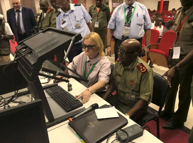
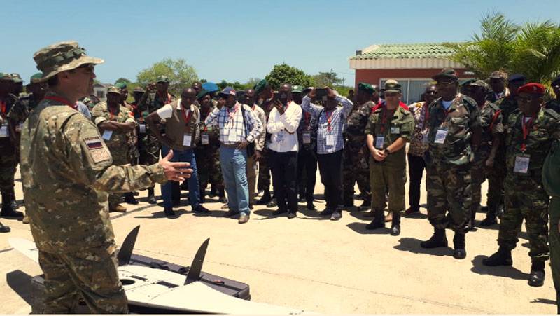
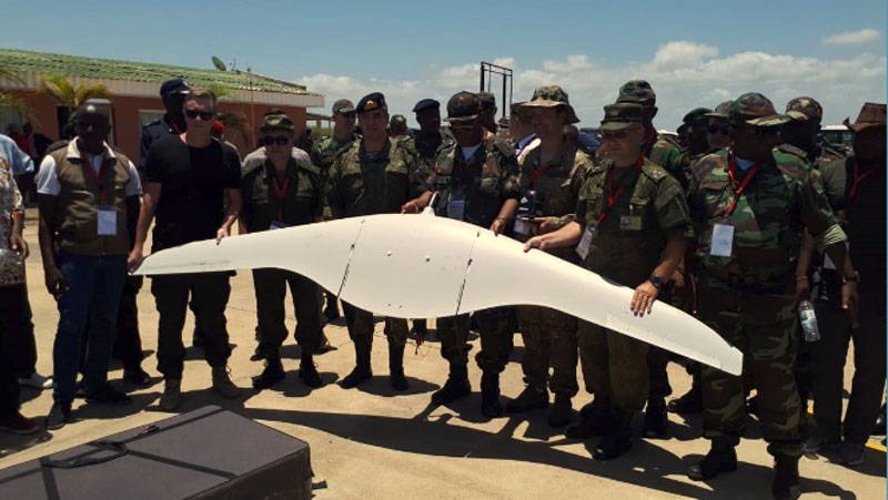
In the course of preparation, the business program of the conference was drawn up and agreed upon. The uniqueness of the format of this conference was as follows: 1. Only Russian developments and technologies were demonstrated 2. During the three days of the conference, a full range of creating cartographic materials (orthophotomap, DEM, 3D terrain model) was demonstrated 3. The first day of the conference was a theoretical introduction to the participants with Russian technologies brought to Luanda. 4. On the second day, not only work (flights) of 4 types was demonstrated drones (aircraft-type UAV SuperCam-350F (for aerial photography), aircraft-type UAV SuperCam-350 (for video reconnaissance), small aircraft-type UAV SuperCam-150F (for aerial photography), copter-type UAV SuperCam-X6M2 (aerial photography), but an aerial photograph was also taken of the area agreed with the Angolan side (more than 100 sq. km) work with these materials (also in Russian software).
The representatives from the Russian side in the conference were: 1. MIIGAiK (training) 2. FINCO LLC (development and production of UAV complexes) 3. Rakurs JSC (software developer for photogrammetric processing of aerial photography materials) 4. Panorama Design Bureau JSC (developer of the Geographic Information System), 5. Ural-Siberian Geoinformation Company LLC (developer of stereophotogrammetric method).
From the Angolan side the conference was attended by (120-130 people): Chief of the General Staff; Commanders-in-Chief of the Armed Forces of the Republic of Armenia; Heads of the Main Directorates of the General Staff of the Armed Forces of the Republic of Armenia; Heads of units, institutions and bodies of the General Staff of the Armed Forces of the Republic of Armenia; representative of the “Security House” of the President of the Republic of Armenia; representative of the “security cabinet” of the President of the Republic of Armenia; Head of Intelligence and Military Security; Chief Inspector, Ministry of National Defense; Commanders of the military, air and naval districts; Head of Engineering; representative of the command of the National Police; management and specialists of the Surveying and Military Cartography Service; students of the Higher Military School; representatives of the Ministry of Higher Scientific and Technological Education, the Ministry of Education, the Ministry of Environment, the Ministry of Transport, the Ministry of Agriculture, the Ministry of Territory Management, the Ministry of the Interior, the Institute of Geography and Cadastre, the National Institute of Statistics, the Institute of Hydrography and Navigation Signs.
The purpose of the conference is the promotion of Russian technologies abroad.
The conference was held in Portuguese. All presentations and handouts were prepared in Portuguese. The first and third days (theoretical) took place at the Higher Military School (VVSh), the second day (flights) took place in the brigade of special forces. The incredibly high level of the conference was due to the active participation of the Office of the Chief Military Consultant of the Ministry of Defense of the Russian Federation abroad in the Republic of Angola.
Summing up the results of the NSSH of the RA Armed Forces, it highly appreciated the level of Russian technologies presented and instructed subordinates to work out the issues of their delivery to interested institutions. In addition, he gave instructions for issuing an invitation to our civilian specialists to participate in their annual military exercises (to make them even closer to know in real conditions). Also, following the results of the conference, the National High School of the Armed Forces of the Republic of Armenia prepared a report to the President of Armenia. During March-April, the needs of some institutions were studied and commercial proposals for their supply were prepared.
But, as already noted, the pandemic began, and everything froze ...
Information