Gravity navigation as an instrument of the future

44

Gravimetric map of Russia and surrounding territories on a scale of 1: 2 500 000. VSEGEI them. A.P. Karpinsky, 2016 / vsegei.com

Several types of navigation systems exist and are widely used, differing in operating principles and measurement accuracy. In the future, a fundamentally new system may be put into operation that calculates the coordinates according to the features of the Earth's gravitational field (GPZ). It is expected that this method of determining the location will be particularly accurate - and at the same time high complexity.

Promising direction


The presence of a developed space group and the improvement of all basic technologies opens up new opportunities for world science. In particular, the presence of high-precision instruments for measuring the physical fields of the planet and objects on its surface makes it possible to compile detailed models of various kinds suitable for use in various fields.


Over the past few years, research has been conducted in our country and abroad in the direction of the so-called gravitational navigation systems. Necessary work is carried out and new data is being collected, processed for further use. The basic principles of the new navigation system have already been identified, and the process of its creation continues.

In Russia, several organizations are working in this direction. In particular, the All-Russian Research Institute of Physicotechnical and Radio Engineering Measurements (VNIIFTRI) from Rosstandart is engaged in the creation of techniques for collecting data and processing incoming information about the gas processing plant in order to create new navigation aids.


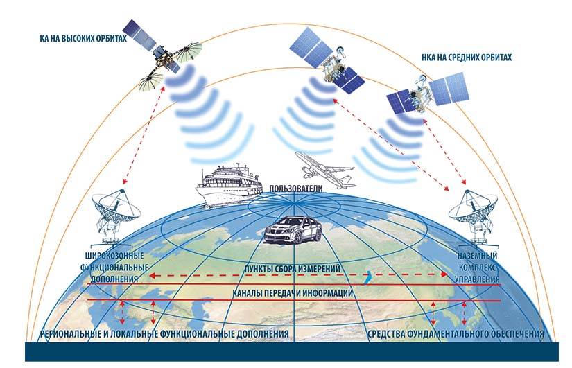
The principles of operation of the GLONASS satellite system. The complex is critically dependent on radio communications, which leads to risks. Graphics IAC KVNO / glonass-iac.ru

Recent reports on the topic of gravitational navigation appeared the other day. The Zvezda weekly, with reference to the leadership of Rosstandart, wrote about the continuation of work on a promising project and the receipt of new results. They also recalled the benefits of new technologies and their applications.

Measurement and calculation


The concept of gravitational navigation is based on the fact that the GEA parameters at different points on the planet's surface (or above it) are slightly different. Earth is not an ideal ball or ellipsoid; its surface has a complex relief, and the thickness of the earth's crust is composed of different materials. All this affects the parameters of gravity on and near the surface. Often, the actual values ​​differ from the calculated values ​​for a given point, which is called the gravitational anomaly. In addition, due to a number of factors, different centrifugal forces are observed at different points.

The concept provides for the measurement of the GPZ parameters and centrifugal force at different points with further processing. The resulting gravimetric map can be entered into the memory of navigation equipment and used in calculations. Based on the data on the GEA, correction of the inertial or satellite navigation systems is possible. In this case, the total error of the entire complex is reduced to centimeters. In addition, the ANN with correction according to the GPZ data is characterized by the highest noise immunity.

Observations show that the GPZ is a fairly reliable "standard" for navigation systems. The rate of change of the gravitational field is much lower than that of the magnetic field, and the GPZ data can be used for decades without a noticeable loss in calculation accuracy. However, earthquakes and other processes can change the state of the gas processing plant and require updating maps.

Practical measures


According to recent reports, Russian scientists - like their foreign colleagues - have been collecting data, searching for gravitational anomalies and compiling gravimetric maps for more than a year. Special equipment on board aircraft and satellites measures the values ​​of fields in a huge number of points and transmits them to ground-based computing centers. The result of this work is a map that can provide high accuracy navigation.

Gravity navigation as an instrument of the future
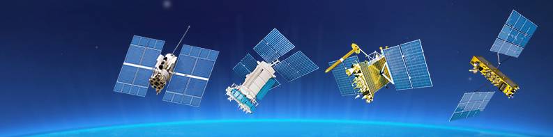
The GLONASS spacecraft of various modifications. Graphics IAC KVNO / glonass-iac.ru

The development of navigation equipment capable of using new maps and interacting with other equipment is also being carried out. However, as far as we know, such projects have not yet led to the appearance of products suitable for actual use.

The introduction of new principles of navigation may be hindered by the lack of accurate maps of a significant part of the earth’s surface. In fact, at the moment, navigation through the gas processing plant in practice does not give special advantages over ANNs or satellite systems. The situation can only change in the future when all the necessary research and design work is completed.

Applications


New principles of navigation can find application in various fields where particularly precise determination of coordinates, independence from external signal sources, and other specific features is required. First of all, this is military affairs. The appearance of gravitational navigation systems suitable for operation will increase the combat effectiveness of a wide range of models of equipment and weapons.

The military may be interested in both increased accuracy in calculating coordinates and unique noise immunity. In fact, the only way to influence such systems is to artificially change the GPP — which requires tremendous efforts or is not possible at all.

A high-precision guided missile, using a gravimetric map, can more accurately follow a given route and hit a target with known coordinates with a smaller deviation. Such principles can be used by both cruise missiles and ballistic missiles. However, such an operation will require an accurate and up-to-date map of the gas processing plant on the route, which imposes special requirements for reconnaissance and organization of the strike.


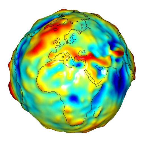
Gravitational anomalies on the surface of the Earth according to the NASA GRACE mission. Graphics by NASA / earthobservatory.nasa.gov

New principles of navigation are of great interest to science. With their help, it is possible to carry out more accurate binding, which is useful in various studies in a number of areas. The accuracy of data collection is improved, and this can become the basis for new important discoveries.

We should not forget about civil and commercial transport. Under normal circumstances, ships or aircraft have sufficient navigation aids, but in some situations more accurate systems may be required. It is possible that the emergence of full-fledged efficient means of navigation through the GPP will interest aircraft and shipbuilders, as well as commercial carriers.

Waiting for success


According to recent reports, VNIIFTRI is now busy compiling accurate gravimetric maps of different areas suitable for further use in practice. Data on the GPZ parameters and the observed forces are processed and converted into a form convenient for use. The development of navigation equipment for implementation in practice is also ongoing.

Both of these components of the new direction are distinguished by high complexity, duration and labor. Unfortunately, even the approximate dates for introducing new technologies into practice remain unknown. In addition, the actual prospects of such developments from the point of view of application in various fields are unclear. Nevertheless, work is ongoing, and real results should be expected in the future. If new technologies reach the application and live up to expectations, a radical change will occur in a number of areas.
44 comments
Information
Dear reader, to leave comments on the publication, you must sign in.
  1. +5
    22 January 2020 05: 17
    With the development of electronics, a cabinet-sized unit is not required for high-precision measurements and subsequent calculations !!! Perhaps they will soon create an "artificial nose" the size of a regular phone and we will follow the trail .... the desired trail ourselves, without the help of dogs!
    However, a dog is not only a good scent, it is a loyal friend whom electronics cannot replace
    Although, for some, a smartphone is already something more than an electronic device ...
    1. -1
      23 January 2020 06: 34
      However, a dog is not only a good scent, it is a loyal friend whom electronics cannot replace

      I don’t know about a friend, but I already have a girlfriend:
      1. +1
        23 January 2020 06: 55
        Quote: pmkemcity
        I don’t know about a friend, but I already have a girlfriend:

        Surrogate .... this is a disease! At a minimum, an individual’s disease ... but it’s not long before the disease of society, if not radically suppressed, be-ee am
        1. -1
          23 January 2020 06: 58
          My friend Sharik ate tomagotchi. Among friends, the same is not all right.
          1. 0
            23 January 2020 07: 03
            If Tomagotchi is Chinese, you can do it. Who knows what polymers, dyes they use!
            I give bones to my Balls, Bobiks, Rex, natural ... let them be healthy.
            1. -2
              23 January 2020 07: 23
              If Tomagotchi is Chinese, you can do it.

              The real for the sake of each other will not regret their belly. "My friend" had a "girlfriend" bitch, so she ate a swim cap. Apparently, that would be more often "friends" with her on the street.
    2. 0
      23 January 2020 07: 57
      There are 10 molecules for the dog to identify the smell. I have a German shepherd. It seems ha the truth.
      1. 0
        23 January 2020 08: 40
        Mother nature tried to give everyone what he needs to survive.
        Only a person can use what was given for survival, to destroy a lot of things that do not interfere with his survival ....
        I will not say that nature made a mistake by endowing us with such brains, but the fact that it did not provide for everything is very similar.
  2. +1
    22 January 2020 05: 52
    However, earthquakes and other processes can change the state of the gas processing plant and require updating maps.

    Ha ... they are constantly happening ... but interestingly, US aircraft carriers passing over the surface of the oceans can change the state of the gas processing plant for a short time ... because such a mass of iron at a small point on the Earth should definitely leave any traces on the instruments.
    1. +2
      22 January 2020 07: 54
      So I have the same thought. How to trust such navigation?
    2. -1
      22 January 2020 10: 21
      The first to invent the gravimeter was the Russian physicist B. B. Golitsyn


      In general, all modern gravimeters work on this principle.
      It used to be called a seismograph.
      1. 0
        22 January 2020 11: 06
        the units of measure on this instrument were Gali, miles of Gala, in honor of the inventor.
        1. +4
          22 January 2020 12: 57
          the units of measure on this instrument were Gali, miles of Gala, in honor of the inventor.

          In honor of the inventor of what? Gal unit - acceleration unit named after Galileo
      2. +6
        22 January 2020 13: 40
        the first gravimeter invented Russian physicist BB Golitsyn
        It used to be called a seismograph.
        To paraphrase Feuchtwanger, an alternative person is alternative in all areas, even in grammar.
        A gravimeter and a seismograph are different instruments. And so they are called so far.
        The gravimeter is used to measure gravity, and the seismograph is used to record seismic waves.
        Golitsyn constructed not a seismograph in general, but an electromagnetic seismograph, which is used in one of the varieties of gravimeters - quartz gravimeters. And they can be pendulum, ballistic, quantum, etc.
        1. -3
          22 January 2020 15: 22
          Quote: Undecim
          To paraphrase Feuchtwanger, an alternative person is alternative in all areas, even in grammar.


          I can also say, if stupid, then this is for a long time.
          and who was the first to design a seismograph? Well, yes, the first of course was a Chinese one thousand years ago, even the design itself was preserved.
          1. +2
            22 January 2020 16: 23
            if stupid, then it's a long time.
            Very self-critical.
            I repeat for especially alternatians - an electromagnetic seismograph, that is, a modern instrument, was created by Golitsin. No one denies this.
            But this is not a gravimeter.
            1. 0
              22 January 2020 23: 14
              The gravimeter, seismograph and accelerometer have a similar operating principle and design: the sensitive element is a test body, a spring. But the measurement range and accuracy requirements are different.
    3. 0
      22 January 2020 18: 15
      Quote: The same LYOKHA
      Interesting US aircraft carriers passing over the surface of the oceans can change the state of the GPP for a short time ..


      I think no. The aircraft carrier is in suspension. That is, if it weighs one hundred thousand tons, then from the place where it is, he, roughly speaking, drove out the volume of water with the same mass of one hundred thousand tons. Since gravity depends on mass and not on anything else, the force of gravity over an aircraft carrier or simply over the sea will not differ.
      1. -1
        23 January 2020 15: 37
        Most likely, it will not be possible to build a dot map of the GPP - too much work, but what's the point? If you have an understanding of the principles of operation of KENS (correlation-extreme navigation systems), then you will also understand the possible (!) Principle of navigation through the GPZ. I mean that the basis of the navigation complex is an (autonomous) inertial navigation system (INS), and the correction of "drifts" of coordinates is made according to the data of "external" or corrective navigation systems (radio navigation, astro-, satellite, radar or optical).
  3. The comment was deleted.
  4. The comment was deleted.
  5. +2
    22 January 2020 07: 51
    I would like to know at least an approximate principle of action. Those. how three-dimensional coordinates are determined from one scalar quantity. Is the influence of solar, and most importantly, lunar gravity taken into account?
    1. The comment was deleted.
      1. +1
        22 January 2020 12: 18
        Quote from rudolf
        By one value only if it is unique. And so on its change and comparison with the gravimetric map.

        What exactly is supposed to be compared with the "gravimetric map"? The force of gravity at a specific point in space? Well, OK. And how to distinguish at which point in three-dimensional space the value of gravity is obtained?
        The question is not idle. There are much more ... more ... easily measurable quantities. For example, a radio signal. The observer having the equipment for the most accurate registration of the radio signal can calculate the azimuth (direction) to the signal source.
        But to determine the place on the surface (i.e., in a flat, two-coordinate system), not one, but two signal sources with known coordinates are needed. Or to determine the signal source, two recorders with known coordinates. Geolocation. But for the third coordinate, in the common people - the height, a third t.s is already required. pivot point with known coordinates. Well, or how it actually happens - other physical properties. For example, measuring the Doppler effect of a modulated signal or something else like that.
        Let's do a thought experiment. Imagine that you are not inside a fast-flying cruise missile actively maneuvering along the route, but in a balloon. You are in an unfamiliar area for the first time. But you have a gravity map. For example, it is graded on a gravity scale in m / (sec squared) with an accuracy of at least one hundred and fifty-decimal places, at least up to two millionth. It does not matter. And now, having the meaning of gravity in your balloon, you need to understand at what point on Earth you are. What you are doing? Describe? Gravity of such small objects as the Moon and the Sun can be neglected. Who cares that they cause complex tidal waves and even currents in the hydrosphere? We have an ultra-precise map. What and with what will you compare?
        1. The comment was deleted.
  6. The comment was deleted.
    1. +2
      22 January 2020 14: 41
      Quote from rudolf
      Drawing up such a map is expensive and troublesome.

      geomagnetic databases in SPbF IZMIRAN
      Reference card supply GraviCENS. The main means of obtaining information about the GPZ in the oceans are marine gravimetric surveying and satellite altimetry. One of the main results of research carried out as part of the Geophysics-R2010 research project is the creation of an experimental GPZ database for the cartographic support of promising CENS (extreme correlation-extreme navigation and guidance systems).
      Currently, about 80% of the water area of ​​the World Ocean is covered by a network of satellite radio altimeter measurements, which makes it possible to determine the heights of the quasigeoid (VKG), gravity anomalies (AST) and the components of the plumb line deviation (RL) with a root mean square error (RMS) of 0,1–0,3, 5 m, 7-0,5 MGal and 2-XNUMX ", respectively.
      Such mapping accuracy allows to ensure the accuracy of autonomous navigation over the sea at the GPZ at the level of 100x200 m;

      Threat.
      gravity alone is not enough.
      In the USA, in 1996 it was created for the BGG strategic submarine on accelerometers located on a rotating platform. Using a special program according to the BGG, a 3-dimensional image of the underwater situation around the boat was formed. If there was a map of the seabed topography, the readings of the onboard ANN were corrected.
      With the help of BGG, it is possible to provide homing of combat units to the center of mass of the target.
  7. 0
    22 January 2020 09: 05
    It is believed that sooner or later, all the same, the satellites will have to refuse too much space debris there.
  8. +1
    22 January 2020 09: 34
    A high-precision guided missile, using a gravimetric map, can more accurately follow a given route and hit a target with known coordinates with a smaller deviation. Such principles can be used by both cruise missiles and ballistic missiles.
    It remains a mere trifle to learn how to filter out accelerations from atmospheric noise, engine operation, fuel fluctuations in the presence of liquid-propellant rocket engines, rocket mass changes and many other factors that exceed the changes in the gravitational field by many orders of magnitude. And what should be the error of gravimeters to ensure "increased accuracy" at least within tens of meters?
    1. Eug
      +1
      22 January 2020 10: 11
      Most likely, the oscillation frequencies of the sensitive elements of gravitational sensors from the factors you cited will differ significantly from the oscillation frequencies caused by a change in the gravitational field. At least in the control system of the BR, when processing information from sensors, the frequencies caused by fluctuations in liquid fuel and the elasticity of structural elements have been successfully and successfully filtered for a long time. Usually, the first four harmonics of forced oscillations are taken into account, i.e., low-frequency and most energy-carrying ones. And the state of the atmosphere is determined by the probability characteristics of the distribution of parameters.
      1. +1
        22 January 2020 10: 54
        Yes, I agree. It is possible to filter out high-frequency oscillations from a slow change in the gravitational field, but it’s very premature to talk about accuracy even in tens of meters. Accurate gravity meters are very delicate and dimensional instruments. The inertial guidance system is no less independent of external factors, but worked out and mass-produced. But for submarines, the system may come in handy.
      2. +1
        22 January 2020 12: 27
        Quote: Eug
        Most likely, the oscillation frequencies of the sensitive elements of gravitational sensors from the factors you quoted will differ significantly from the oscillation frequencies caused by a change in the gravitational field ...

        Oscillation frequencies? I thought that the gravitational field of the Earth is a constant thing in time at every point in space. Remember - we are in a balloon. For simplicity, let's tie it to the surface so that it does not hang out and fly away. What exactly are we measuring?
        1. 0
          24 January 2020 08: 48
          It is about changing the gravitational field during movement.
          1. 0
            24 January 2020 09: 34
            Quote: Michael m
            It is about changing the gravitational field during movement.

            It doesn’t explain anything at all, because in motion you need to everything else except the initial coordinate and calculate the motion vector.
            This is even worse than looking through a microscope at a moving outline map.
    2. +2
      22 January 2020 11: 39
      I will add the influence of the movement of celestial bodies. The tides caused by the sun and moon, no one has canceled.
  9. Eug
    +1
    22 January 2020 09: 55
    Can the GPZ navigation system use not linear GPZ parameters, but areal parameters, similar to how TERCOM and DSMAC use elevation maps? Well, building onFigration (as we at the institute called it) only on maps is risky, rather for correcting well-known and well-developed inertial systems. Although the noise immunity of gravity systems is theoretically much higher than systems with correction according to the radar map of the area, the accuracy will very seriously depend on the accuracy of the gravity field measurement. But how and to what extent its parameters vary due to various factors and how accurately these changes can be taken into account, alas, are not up to date.
  10. +4
    22 January 2020 10: 31
    At the moment, navigation through the GPZ does not require increased accuracy (compared to satellite systems), but simply accuracy (compared to inertial systems) - with the aim of using hypersonic aircraft and warheads (surrounded by a plasma envelope) in guidance systems, as well as underwater vehicles (not able to constantly use satellite navigation or bottom sonar).

    At the beginning of the 2000s, the accuracy of gravity guidance systems was approximately 200 meters, which is quite enough to hit targets with thermonuclear charges with a capacity of 100 kt or more. However, the size of the gravimeters was too large to fit into the limited volume of the BB. Now there are so-called quantum gravimeters the size of a shoe box and their volume will decrease. It can be predicted that after drawing up a detailed gravitational map of the Earth and organizing a satellite-based monitoring system for its changes, an order of magnitude greater accuracy will be achieved.
  11. 0
    22 January 2020 11: 37
    The rate of change of the gravitational field is much lower than that of the magnetic field, and the GPZ data can be used for decades without noticeable loss of calculation accuracy.

    The author, as always, did not bother even a little deeper in the topic.
    Gravity values ​​change CONTINUOUSLY. Because it is influenced by the Sun and Moon, as the most closely located celestial bodies. It is believed that more or less they are stable, about 2 hours. Further, the accuracy of measurements decreases due to the motion of celestial bodies. Any student of a technical university knows this. Yes, and this information is available to anyone.
  12. +2
    22 January 2020 12: 37
    Gravimeters have long been used in geological exploration. However, our gravimeters, like accelerometers and gyroscopes, have always had significantly worse accuracy characteristics. Although something has been done, there is no evidence that the Russian Federation has reached the technological level that allows the method to be put into practice. But what we were able to do was to "integrate" primary measurements (signals from sensors). This is pure mathematics. In addition, the computing power of modern on-board computers does not create severe restrictions that were characteristic of on-board computers in the mid-1970s and early 1980s. This is the "instrument of the future". In short, for the future to come, breakthrough technologies are needed that are ahead of the development of the industry. This means that someone must create appropriate systems for the production of actual achievements in the field of fundamental and applied science.
    1. +2
      22 January 2020 13: 55
      In the mid-90s, when, when we asked the Americans for investments, we showed them almost all of the GKZ reserves, even strategic raw materials (uranium, gold, etc.). Of the geophysical materials, only the results of high-precision gravity exploration were not allowed to be declassified. I think the results of high-precision gravity surveys in geology are a good starting point for building a good GPZ map.
  13. 0
    22 January 2020 15: 12
    And what is already compact gravimeters with sufficient accuracy that can be shoved into the CR or at least into an airplane?
    And in terms of mapping, the key issue is the availability of a sufficient constellation of satellites. What are the big problems.
  14. 0
    22 January 2020 18: 09
    My question is completely stupid: how can a satellite measure the gravitational field of the Earth, if he and everything on board are in a state of free fall, i.e. in zero gravity?
    1. +1
      22 January 2020 23: 11
      Quote: "With high-precision measurements of gravity, you must ensure that when leveling the gravimeter, its height does not change by more than 3 mm, which corresponds to a change in gravity by about 1 μGal." End of quote.
      What is there to add?
  15. 0
    23 January 2020 14: 55
    will there soon be an era of antigravity?
    1. 0
      29 January 2020 12: 44
      While the enemy is preparing to strike, we change the terrain (and manually). In this case, the gravitational field also changes.
  16. +1
    24 January 2020 17: 38
    Sounds like complete nonsense. How can you detect gravity anomalies for the orientation of aircraft or some other moving objects? After all, if the apparatus is not affected by any external forces except gravitational (satellite), then everything inside will be in "weightlessness", ie, everything will be accelerated by gravitational flight in the same way. No gravitational anomalies can be detected by instruments inside, except by measuring the trajectory of this apparatus, for example by GPS. But if GPS is available, then no orientation is needed. And in the atmosphere, as well as on water and under water, there are always some micro-accelerations caused by wind, waves, currents. And it seems that everything is getting heavier or lighter. How can this be distinguished from gravity anomalies? Sounds like complete nonsense.