Falsification of history as a type of aggressive war
 We present to your attention the article “Several examples of incorrect dating of known historical events. Historical and political research ".
Introduction
The state of modern historical science has become especially clearly understood this year - the 2012 year was declared by the President of Russia Dmitry Medvedev “Year of Russian History”. As of July 15 (exactly half a year has passed), no results of this Year have been presented to the public. None of the relevant institutes of history of the Russian Academy of Sciences gave either the Russian people or the Russian president any work, the results of which at least somehow shed light on at least some controversial moments in Russian history.
And there are many such moments. Suffice it to say that we “officially” do not know anything from the history of our people, which clearly took place before 9 - 10 of the centuries of our era. The “official” historical science still forces us to teach our children on historical materials formed back in 18 - 19 centuries. And despite the fact that such materials were openly concocted by persons who in those years were openly criminal in relation to Russia. We specifically do not call here any historical surnames, because this article is intended for historians, who, of course, should independently recognize the characters described in it.
Political Aspects of Falsifying History
What, for example, achievements in the field of the history of the Russian language have recently issued specialized institutions for the study of the Russian language? Almost none. We still do not know the time of the emergence of the Russian language, or the place or the trajectory of its development. All information about our native language is still generated within the walls of foreign intelligence services and academies and universities under their control. And in these conditions, as before, some “scientists” of corresponding origin give a fable that the Russian language, supposedly, was formed in the Middle East. Other "scientists" sing along with them and bring the "ancestral home" of the Russian language beyond the lands occupied today by the Russian state.
This is done in order to shape in the minds of Russians the confidence that the Russian people are newcomers on Russian territory. The calculations of such “scientists”, controlled and directed by the secret services of hostile countries, have such an ultimate goal: “The Russian people must become convinced that they are strangers on Russian soil, that the Asians have given their language, and now the time has come for the Russian people peoples that are much more ancient than Russian. "
Thus, historical linguistics and history are in the hands of skilled executioners. weapons mass destruction, capable of clearing the Russian open spaces from such intractable and so invincible conventional armament of the Russian people. And if such a - historical - victory over the consciousness of the Russian people takes place, then foreign companies and foreign conquerors formed from exclusively “friendly” peoples to us will only have to persistently ask to free “their” “historical” homelands from our presence.
Tatar falsification of Russian history
We give only one example of real combat operations using historical warfare. We are talking about a fictional people - "Tatars" and its fictional "homeland" by historians, which today is criminally identified with the territories of the Russian Volga region. Today, Tatars expel Russian people from this territory, transfer to the Tatar language, in general, engage in illegal activities that violate the Russian Constitution and are aimed at the segregation of Central Russian lands. That's how it all happened and happens.
In 2005, the Tatar diaspora summed up historical “evidence” under the dating of “its” capital, Kazan. As a result, the Tatars officially celebrated the millennium of this Russian city. That is, the Russian city of Kazan was founded in 1005 year according to the “new historical” data obtained by the Tatars. This fact does not worry us much. We are outraged that the Russian city of Kazan is now represented in the status of an 1000-year-old city as the capital of the Tatar ethnic group.
But even in the 19 century, the Tatars called "a whole series of peoples of Turkic origin, with an admixture of Mongolian elements speaking Turkic language ... In the 5th century. under the name of Tat or Tatana (hence the word Tatars probably originated), the Chinese understood the Mongolian tribe that lived in the north-eastern part of Mongolia and partly in Manchuria, between the Khalkha, Karulen and Sungari rivers. In the XI century. Tatars were conquered by the Tungus and partly migrated to southwestern Mongolia. ” In the XII century. Genghis Khan formed a powerful kingdom in Central Asia from a multitude of Turkic peoples, who became known as the Tatars, and the Mongol element and language were absorbed by the Turkic. In 1223, one of Genghis Khan's troops penetrated the Caucasus. Another part of the Tatars broke the Polovtsian and Russian princes by the Kalka River. The successor of Genghis Khan sent his nephew Baty to conquer western countries; 1237 Tatars conquered Russia, defeated Hungary and Poland; but further movement to the west was blocked by the militia of the Czech king and dukes of Austria and Carinthia. The Tatars turned back and founded the Golden Horde on the Volga, from which the Crimean, Astrakhan and Kazan Khanates stood out. In the XVI century. in Siberia, the independent Khanate was founded by Tatars who lived along the Ob, Irtysh, Tavda, and Ingul rivers and their tributaries; it was conquered by Yermak ”[Brockhaus and Efron, 1909].
Naturally, we understand that in the 19 century, historians were specialists who were able to understand the scientific component of the historical sources available to them. Therefore, no doubt about the fairness of the above can not arise. This means that the Tatars appeared on the Volga and began to base something only in the 13 century. In this regard, it becomes obvious that for three centuries the Tatars attributed their “own” Kazan too, although to be more precise - for the first three centuries Kazan was not a Tatar city, and not Tatars were founded by Kazan.
After the gift of the Soviet government, which handed out native Russian lands left and right, outstanding experts on the history of the Tatars R. G. Mukhamedova and A. Kh. Khalikov wrote: “Tatars, the main population of the Tatar ASSR (1536 thou. . The language of the Turkic group of the Altai family of languages. For the first time the ethnonym "Tatars" appeared among the Mongol tribes who wandered in 1970 - 6 centuries. southeast of Baikal. In 9 c. with the Mongol-Tatar invasion, the name "Tatars" became known in Europe. In 13 - 13 cc. it was extended to some peoples of Eurasia, which were part of the Golden Horde. In 14 - 16 cc. in the Russian sources, many Turkic-speaking and some other ethnic groups living on the outskirts of the Russian state (Azerbaijanis, a number of ethnic groups of the North Caucasus, Central Asia, the Volga region, etc.) began to be called Tatars. For some of them, the name Tatars became an ethnonym. ... In 19 - 15 centuries, during the existence of individual feudal states (Kazan, Astrakhan, Crimea, Siberian and other khanates), separate groups of Tatars — the Middle Volga and Ural regions (Kazan Tatars, Mishars), Astrakhan, Siberian, Crimean and others. ”[TSB].
We see that for more than a century the position of historians has not changed: the Tatars are a Mongoloid Chinese tribe who illegally settled on the Russian lands in the late Middle Ages.
But after another successful attempt of the collapse of Russia (the collapse of the USSR), the peripheral peoples snatched solid pieces of "their ancestral" Russian lands. But the Tatars are not lucky in this matter. Therefore, in order to make their history “old”, they even went for a complete rejection of their own national identity - “the Tatars are direct descendants not so much of the Golden Horde people as the indigenous people of Volga Bulgaria, conquered by the Mongols at the same time as Russia”. And this is not an April Fool's joke. On this basis, the President of the Bulgarian National Congress (Republic of Tatarstan), Gusman Khalilov appealed to the European Court of Human Rights and demanded to rename the Tatars into Bulgars [idiatullin, 2000]. The court did not support the Tatar joke.
It was an example of the active expansion of various peoples, aimed at reforming their history and the history of Russia. And the criminal intent here is that by falsifying the history of the Tatars to form the Tatars the right to the territory of another nation, the Russian.
Falsification of the history of the Russian city of Kazan
The fact that the Tatar diaspora "established" the date of the foundation of Kazan at the level of 1005 of the year speaks not only about the falsification of the age of this Russian city. This action exposes all the cynicism of the "official" historians, with which they approach the purity of their subject. If in newspapers, on television and on radio, “official” historians are choking with indignation at “unprofessional” study of history, then at gatherings paid for by national criminal gangs, these same “official” historians are blowing in one pipe, in common with criminals who actually falsify history. Again, we will not name names, you can learn them from the official collection of the conference, the one on which the age of the Russian city of Kazan was set.
But there would have been no Kazan falsification if at least one of several dozen professional historians present at that conference got up and just read a quote from the Encyclopedic Dictionary of Brockhaus and Efron: “Kazan was founded in the second half of the 12th century; in our chronicles the city is mentioned for the first time at the end of the XIV century. The old city was previously near the place where now is the village of Knyaz-Kamaev; the ancient settlement that has survived here still bears the name of Old Kazan; in its present place the city exists from the 15th century. ”[Brockhaus and Efron, 1907].
Moreover, at the location of the Old Kazan, there is a state museum - the Iske-Kazan State Historical, Cultural and Natural Museum-Reserve, in which 14 employees work, of which 4 is a scientific employee. The average number of visitors per year is 6600 people [EKGMZ, 2012].
Old Kazan is located "in 45 km northeast of present-day Kazan, near the villages of Tatar Aisha, Kamaevo, Russian Urmat of the Vysokogorsky District of the Republic of Tatarstan". Here, “on the sacred place in the whole Order, there is a whole complex of unique historical, cultural, archaeological, and natural objects that are now included in the protected zone of the Iske-Kazan State Museum-Reserve. “Lawsuit Kazan” in Russian means “Old Kazan” [IKGMZ, 2012].
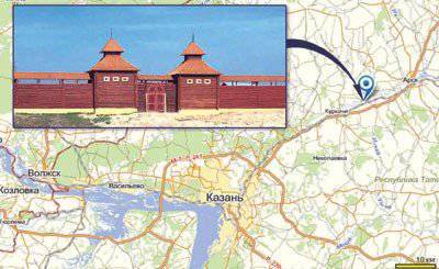
Fig. 1. Old Kazan. Located in 45 km northeast of modern Kazan.
Professional historians could not know such a "little things." But, for political reasons, they were silent. And this is understandable. But the fact that all of their ostepenennym composition at the ill-fated conference made an attempt to falsify the Russian history, should give a legal assessment of the Prosecutor's Office of the Russian Federation.
Falsification of the existence of the Kazan Khanate
Another fiction of historians is the Kazan Khanate, which allegedly appeared after the collapse of the Golden Horde. In the vocabulary articles about this “Khanate”, the authors exaggerate with “historical accuracy”. For example, Kazan, ostensibly, from 1438 of the year (1553) becomes the center of the Kazan Khanate, and, allegedly, the layout of the streets of Kazan was confusing and concentrated towards the Kremlin.
However, no written evidence of the Kremlin does not exist. And only in the 1556 year, that is, after the fictional Kazan Khanate disappeared from the historical arena, 200 of the Pskov bricklayers headed by Postnik Yakovlev and Ivan Shiriy arrive in Kazan, and only 1568 stone towers and a large part of the Kremlin walls were built by 13. Nowadays, the white-stone Kremlin, the most southern example of the Pskov architectural style in Russia.
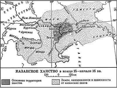
Fig. 2. "Kazan Khanate" [TSB].
It is believed that only in 1552 was Tsar Ivan IV seized Kazan and annexed the territories of the Khanate to the Moscow State. However, on the maps of that time and earlier no "Kazan Khanates" and other khanates were applied (see, for example, Fig. 3 and 5). On all maps of the time of the "Kazan Khanate" existence, "its" territories are included in Muscovy or in the Moscow Empire. Moreover, all the toponyms on the same maps are Russians - there are no Turkic names.
And, of course, they could not have been in those times, since there was no Tatar language then. “Tatar languages is an outdated term for some Turkic languages. The word "Tatars" is a Mongolian tribal name, denoting historically Mongolian commanders of multi-tribal troops during the so-called "Tatar invasion" in Russia. At the same time, apparently, this term was transferred to the Turkic nationality, which was part of these troops and settled in the Middle and Lower Volga region ”[LE].
If we continue the study of the Tatar language, we find that it is the language of only Islamic religion (like Arabic today), which was formed only by the 19 century, and significant literature began to form only after the revolution [LE].
And yet, as the main population of the “Kazan Khanate”, usually only “Tatars” and “Chuvashs” are called. We have already shown above that the Tatars are a Chinese tribe that illegally settled on Russian lands only in the 13 century. But the Chuvash are the same. “Significant Chuvash groups live in Tatarstan and Bashkiria, where they moved back to 17 - 18 centuries ...” [TSB]. That is, Chuvash did not live in Kazan since the time of the Kazan Khanate, before their arrival there were still whole 3 - 4 centuries.
If we systematically process all the data, and also study the ancient maps, which are now very widely available, then a picture emerges that shows the full scope of the “official” historical falsification. This whole series of “khanates”, which the national “outstanding” “scientists” root in the primordially Russian territories, has taken such a scope that it is no longer difficult to place the fictional “khanate” in the very center of Russia.
"Official" scientists are not interested in such subtleties as the distance in 45 kilometers between the old and new Kremlin and the city, "scientists" are not even interested in the lack of language and the people themselves, who are credited with creating this or that "khanate." “Scientists” are only interested in one thing - to sow in the territory of Russia “ancient states” as much as possible, who would then generously pay for their withdrawal from Russia by this “honest” “official” scientist.
Falsification of the founding date of the city of Tyumen
Imagine the Russian side of history, which shows the scientific impotence of the "official" schools and institutions, and thus allows entire nations to cheat with historical dates, and with the political consequences of the substitution of dates.
The “traditional” story tells us that, supposedly, the conquest of Siberia by the Russians is a process that took place in the second half of the 16 — 19 — centuries. In this context, supposedly, “traditionally” it is considered that its beginning falls on the 1580 year and coincides with the campaign of Yermak Timofeyevich with the Cossacks (1581 - 1585) on a certain “Siberian Khanate”. In 1586, a certain Vasily Sukin founded Tyumen, which supposedly is the first Russian city in Siberia and supposedly located on the site of the former capital of the Siberian Khanate. In 1587, supposedly, Tobolsk was founded on the Irtysh River.
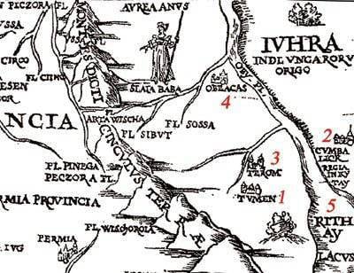
Fig. 3. Fragment of the Muscovy map of Sigismund von Herberstein, created in 1549 year [Map, 1549].
The Sigismund von Herberstein map of Muscovy was compiled in 1549. It is based on the material of his trips to Russia in the reign of Vasily III. As it is known, Vasily III Ivanovich was born in 1479, and died in 1533 year. Grand Prince of Vladimir and Moscow, he was in 1505 - 1533. Baron Sigismund von Herberstein (him. Siegmund Freiherr von Herberstein) was born in the 1486 year, and died in the 1566 year. The most famous in Russia and abroad acquired for his extensive works on the geography, history and internal structure of the Moscow Grand Duchy and Kingdom. Herberstein’s (second) visit to Muscovy took place in 1526.
Thus, the date of the visit (1526), the years of the life of Russian Tsar Vasily III (1479 - 1533) and Sigismund Herberstein (1486 - 1566), as well as the date of the map of Muscovy (1549) made by him - everything is in full accordance. So, on the Herberstein map (see fig. 3) there is already a city of Tyumen (1), although according to the “official” version, there were still 37 years left to its foundation. In addition to this city, there are three more cities on this map fragment - these are Obelkas (4), Terom (3) and Kumbalak (2), and there is also a lake China (5).
It turns out that the “official” version that Tyumen is supposedly the first Russian city in Siberia and was founded in 1586 by a false Vasily Sukin.
Falsification of the founding date of the city of Perm
Such a false situation has developed not only with Tyumen, but also with several ancient Russian cities.
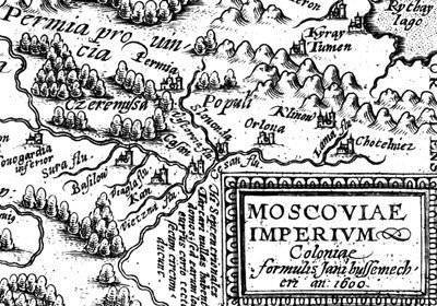
Fig. 4. Fragment of the map "Moscow Empire" (1600 g.) [Map, 1600].
This is how the Great Soviet Encyclopedia speaks about the founding of the city of Perm: “In 1723, on the site of the village of Yagoshikha (originated at the beginning of the 17 century) at the confluence of Yagoshiha in Kama was built copper smelter with a village, renamed 1781 in the city. With 1781, Perm is the center of the Perm governorship, with 1796 a provincial city ”[TSB, art. Permian]. On the map of the Moscow Empire, made in 1600 year (see Fig. 4), the city of Perm is already present. Moreover, Perm province is also designated, which clearly indicates the importance of the city. And this is 123 before it supposedly appeared!

Fig. 5. Fragment of the map of Tartaria (Scythia) by Sebastian Munster. Basel. According to the materials of Sigismund Gerberstein. Woodcut. 1544 G. [Map, 1544].
We see the city of Perm and the Perm province even earlier - on the map of Tartaria (Scythia) of Sebastian Münster (see fig. 5), which he produced in 1544 using materials from Sigismund Herberstein [Map, 1544]. Perm is also listed on the Asian side of 1593 of the year [Map, 1593], as well as on the world map of Herbert Northern (Habrecht Northern) 1628 of the year [Map, 1628]. Perm and the Perm province are indicated in the mentioned Herberstein map 1549 of the year [Map, 1549]. Perm is indicated on the Mercator map of Europe created in 1595 [Map, 1595], as well as on the map of Muscovy compiled by Gerard Hessel in 1614 [Map, 1614] and on many other maps of different compilers from different countries.
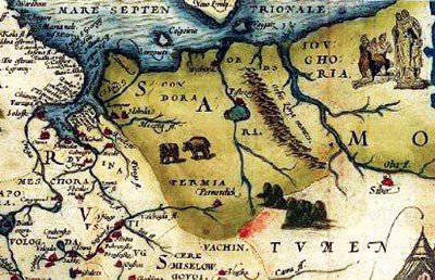
Fig. 6. Fragment of the map "Location of Russian Muscovy and Tartaria" by Anthony Jenkinson, created in London in 1562 year [Map, 1562].
On the 1562 map of the year “The Location of Russian Muscovy and Tartary” by Anthony Jenkinson (see fig. 6), Perm (Perm Velikiekaya) and Tyumen are also indicated. And all this before the "official" dates. It turns out that the city of Perm and the Perm province existed at least 196 years before the “official” foundation of the city of Perm, and all the geographers of Europe knew about it, put both the city of Perm and the eponymous province into the correct place of maps, as a stable and large city so large that He even had to be shown on world maps. But the Soviet and Russian “official” historians, who, apparently, were taught, were able to find only the date of the “foundation” of Perm relating to the 18 century with their insignificant attempts. Is it a disgrace to Russian and Soviet historical science? Or is it a deliberate sabotage of "official" historians of the correct presentation of Russian history.
Falsification of the opening date of the Bering Strait and Alaska
A similar situation exists with the "discovery" of the Bering Strait and the Russian Alaska. Again, the Great Soviet Encyclopedia contains the following phrase: “By the time Alaska was discovered by Russian explorers in 17 c.”. However, what exactly this phrase means is not clear. If the fact that in the 17 century Russian explorers discovered Alaska, it differs from the subsequent proposals from the same TSB article: “By the middle of the 30's. 18 century, thanks to the expeditions of P. Nagibin, V. Bering, A. Melnikov, I. Fedorov, M. Gvozdev, the first surveys of Alaska were conducted, but only with the expedition of A. Chirikov 1741, the opening of Alaska is accepted ”[BSE] .
Another encyclopedia gives more accurate data: “The first individual information about Alaska was received by Russian explorers at the end of 17 c. On the map of S. Remezov (1701) based on the data of V. Atlasov and others. Alaska is depicted as an island. Practical results on the survey of Alaska were achieved in 1732 (I. Fedorov and M. Gvozdev). As a result of the expeditions of V. Bering and A. Chirikov (1728, 1729, 1741), the most important data on the nature and population of a part of the Alaskan coast were obtained. With the 1741 expedition, it is common to associate the discovery of Alaska ”[SIE].
According to the western version, it is “accepted” to consider that the first white man to set foot on the land of Alaska was G. V. Steller, a naturalist from the ship of V. Bering (1728) [Alaska, 1993]. However, “actually” the first representatives of Western civilization who visited Alaska 21 in August 1732, were Russian seafarers - members of the “St. Gavriil ”under the supervision of geodesist M. S. Gvozdev and the sub-navigator I. Fedorov during the expedition of A. F. Shestakov and D. I. Pavlutsky 1729 - 1735 [Aronov, 2000; Vahrin, 1993]. In 1778, James Cook embarked on an expedition to the shores of Alaska.
It is believed that the Russian navigator Semyon Dezhnev on his 1648 expedition, the first to go around the Chukotka Peninsula, i.e. 80 years before Bering opened the strait separating Asia from America. In early October, the ship Dezhnev moored to the coast south of the mouth of Anadyr. Dezhnev compiled a drawing of the Anadyr River and parts of the Anyuya River (a tributary of the Kolyma), and in petitions (they are known 4) described his voyage and nature of the Anadyr Territory [SIE]. There is fragmentary information about Russian visits to America in the 17th century [Sverdlov, 1992].
Fig. 7. Fragment of the map of Asia, released in Amsterdam in 1632 [Map, 1632].
In fig. 7 is a fragment of the map of Asia, released in Amsterdam in 1632 year. The dating is indicated on the fragment. Immediately recorded and the Bering Strait itself and the American land, that is, the coast of Alaska. The eastern shore is correctly given: the lands of Sina, the Wall of China, Japan, Korea are shown. This card was in circulation already 16 years before the mission of Dezhnev.
Fig. 8. Fragment of the map of the Tartar Empire, released in Padua in 1621 year [Map, 1621].
On the map of the Tartar Empire, released in Padua in 1621 year (see fig. 8), the strait is also indicated, both banks are Russian and American. Japan is shown below. That is, the basic guidelines are given correctly. And this is 27 years before Dezhnev. The Atlas of Abraham Ortelius 1570 of the year [Map, 1570] shows both the lands of Alaska and the lands of the Far East, and the strait between them.
The modern "face" of Russian historical science
In the article, we did not specifically name the name of a single scientist from that galaxy of “remarkable” “official” researchers, by whose efforts national groups falsified Russian history. However, one exception - for the purposes of example - we will make. This is a teacher from Bryansk Arthur Chubur. To begin with, in 1991, he graduated from the Faculty of Ufology of a certain “All-Union School” “Basis”. And after that, immediately became the "official" "academic" "scientist."
“But the VAK of the Russian Federation withdrew his last dissertation from consideration due to the falsification of the approbation documents by the applicant. Digging up the Bulls site in the Kurchatov district. The Kurchatov period of his work ended in conflict with the city museum of local lore, of which he arbitrarily brought part of the funds to Bryansk, roughly speaking, stole. For the activities of A.A. Chubura is characterized by a bizarre combination of extraordinary energy and dubious techniques of field and office work, unfortunately, indicative of a number of representatives of the most recent generations of Kursk historians and archaeologists ”[Schavelev, 2009]. In this regard, journalists nicknamed Chubura “Bryansk Mavrodi” [Gorny, 2012].
So it turns out that under the guise of the sign "official science" such chuburs distort Russian history, crying with joy: "Rashka in flight" (Chubur). But true conscientious researchers have to clear up them later - and then, this is if the authorities hear them in time.
Discussion
We presented only a few examples of incorrect datings of famous historical events - those that are studied in school. You are surprised to find that faith to “official” historians is akin to religious faith. However, if religious faith allows pastors to manipulate the most uneducated and gullible “sheep”, then faith to unclean “official” historians allows the forces behind their backs to manipulate entire countries and their property.
And these manipulations already concern not only ancient history, but already the newest one. In such conditions, experts of political wars can, armed with “reliable” “historical” data, snatch a piece of the territory of an entire country, evict its people, and seize entire areas with mineral resources. And if someone believes that this problem - the problem of falsifying history - is far-fetched and not entirely relevant to modernity, then he is deeply mistaken. The squandering of Russian lands under fictional "historical" pretexts continues to this day. Recall the event.
Just a few days ago, on July 12 of Russia, 2012, Russia donated the Russian island of Tuzla to Ukraine [Tuzla, 2012]. If the document on the transfer of Russian land will be ratified in the State Duma of the Russian Federation, this gift will take a legal form. Meanwhile, the island of Tuzla was formed from the Tuzla Spit, which, in turn, was a continuation of the Taman Peninsula. The spit was blurred in the 1925 year, but the Taman Peninsula itself, along with Tuzlinoska, was always located east of the Kerch Strait, that is, it belonged to Asia, and, therefore, to Russia.
And on September 15, 2010, Russia donated Norway 90 thousands of square kilometers (a territory approximately equal to the size of Portugal) of the sea possessions of Russia. The State Duma of the Russian Federation criminally ratified the transfer document. In 2004, Russia gave China several Russian islands on the Amur River with a total area of 337 square meters. km And this "deal" the State Duma ratified.
But perhaps the most inhuman act from all points of view, took place in September 2010, when Russia presented Azerbaijan with half of the water intake of the Samur River and two Dagestan villages along with 600 Russian citizens living there. The worst thing is that no state recognized any borders of Azerbaijan, therefore the transfer of lands and people that took place is a doubly monstrous act. But even more monstrous is the explanation that Deputy Foreign Minister Grigory Karasin, who presented the document to the Duma, allowed himself. He simply mocked: "So the story is disposed, we will maintain contacts with them."
Conclusion
As it should be in science, the new data do not always confirm the old theories. Let us recall at least the epic with the Earth and the Sun: even after the Christian Inquisition burned the bearer of a new theory, the Sun did not revolve around the Earth. So in today's story - the influx of national fraud literally tears apart the territory of Russia, and all this is served from the "official" position. But truly wise people see that behind such clarifications of history there is only the criminal intent of individuals or groups, due to the seizure of Russian lands, under which the “new owners” are trying to bring the “official” “historical” base.
References:
Aronov, 2000. Aronov V.N., Patriarch of Kamchatka Navigation // “Questions of the history of the fishing industry of Kamchatka”: Local history collection. - Vol. 3. - 2000.
Brockhaus and Efron, 1907. Encyclopedic dictionary of F.A. Brockhaus and I.A. Efron. - 1890 - 1907.
Brockhaus and Efron, 1909. Brockhaus and Efron Small Encyclopedic Dictionary / In modern spelling. - Petersburg: Publishing Society “F.A. Brockhaus - I.A. Efron, 1907 - 1909.
TSB. Great Soviet Encyclopedia: In 30 T. - M .: "Soviet Encyclopedia", 1969 - 1978.
Vahrin, 1993. Vakhrin S., Conquerors of the Great Ocean. Petrop.-Kamch .: Kamshtat, 1993.
Mountain, 2012. Yuri Gorny. Arthur Chubur - Bryansk duplicate of Mavrodi. Newsland. 26.03.2012.
IKGMZ, 2012. Lawsuit-Kazan State Historical, Cultural and Natural Museum-Reserve. 422730, Republic of Tatarstan, Vysokogorsky District, p. Kamaevo. Tel. (84365) 70-2-78. Site http://www.museum.ru/M1312.
Map, 1544. Tartary (Scythia). Sebastian Münster. Basel. According to the materials of Sigismund Gerberstein. Woodcut. 1544
Map, 1549. Map of Muscovy. Herberstein 1549
Map, 1562b. Location of the Russian Muscovy and Tartary. Anthony Jenkinson. London. 1562 year.
Map, 1570b. Atlas of Abraham Ortelius 1570 of the year.
Map, 1593. Asian Part (Asia Partum Orbis Maxima. Gerard de Jode), 1593
Map, 1595. A map of Europe. Mercartor. 1595
Map, 1600. Moscow Empire. 1600
Map, 1614. Map of Moscow, compiled by Gerard Hessel. 1614
Map, 1621. Tartar Empire (Descripttione del potentissimo imperio de la Tartaria. Galignani, P & F., Padua, 1621), 1621
Map, 1628. World Map (Hemisphere). Northern Habrecht. 1628
Map, 1632. Map of Asia. Amsterdam. 1632
Le. Literary Encyclopedia: The 11 T. - M., 1929 - 1 939.
Sverdlov, 1992. LM Sverdlov, Russian settlement in Alaska in the 17th century? // Nature, 1992. No. 4. - S. 67 - 69.
SIE. Soviet historical encyclopedia. - M .: Soviet encyclopedia. Ed. E.M. Zhukova. 1973 - 1982.
Tuzla, 2012. Russia and Ukraine agreed on a maritime border. "Lenta.ru". 12.07.2012, http://lenta.ru/news/2012/07/12/sign1/
B-idiatullin, 2000. Shamil b-idiatullin. Tatars are not Bulgarians. Kazan Kommersant, No. 205 (2090), November 1 2000.
Schavelev, 2009. Historians of the Kursk region. Biographical dictionary. Comp., Resp. ed. S.P. Schavelev. Kursk, publishing house of Kursk State. Medical University, 2009.
Alaska, 1993. The Alaska Almanac. Facts About Alaska. 17th Edition. - Alaska Northwest Books, 1993.
Information