Chinese navigation system "Beidou". Do Americans have to make room?
The Chinese satellite navigation system "Beidou" is preparing to push the US GPS in the world market. On September 2019, China deployed 42 navigation satellites in space, 34 of which are used for their intended purpose. Given the support from the Russian GLONASS satellite navigation system and the problems of the Galileo European navigation system, which was shut down for several days in July 2019 in July, the Chinese Beidou system is considered the only navigation system that can challenge the United States.

In China, we thought about our own satellite navigation system in the 1983 year. The first experimental verification of the system concept, in which only two satellites were used in geostationary orbits, took place in 1989. Five years later, in 1994, the first stage of the deployment of the Chinese satellite navigation system, called "Beidou", translated from Chinese as the "Northern Bucket" (as the UPR is known to everyone in China) began. The system was developing gradually, the first generation of Beidou-1 satellites was put into operation in the 2003 year. It was only three satellites, all of them have already been taken out of the orbit of the Earth. The Beidou-1 system was a continuation of the experiment at a new technological level.
The second implemented system, Beidou-2, was already fully operational, but provided only regional positioning. The main purpose of this satellite system was to provide reliable coverage of the entire territory of the PRC, as well as the adjacent Asian states. The system was deployed from 2004 to 2012 year. In total, during this time, China launched 14 navigation satellites into space, of which five satellites were located in geostationary and inclined geosynchronous orbits, and the four remaining satellites were in medium orbits. The expanded satellite constellation was compatible with the Beidou-1 system. For China and the Chinese space industry, this was a significant step forward. By the end of 2012, the country was able to provide users located in the Asia-Pacific region with access to services to determine the exact location, time, speed, etc. Most of these satellites are still in operation.
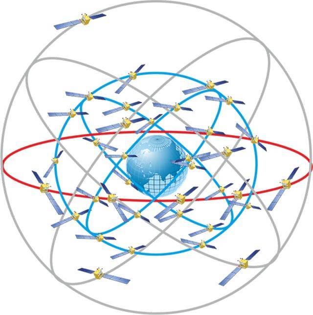
The third stage of development of the Chinese satellite navigation system was called Beidou-3. This system is already positioned as global. It is Beidou-3 that will directly compete with the American GPS, the European Galileo and the Russian GLONASS system. The PRC expects to completely complete the deployment of the system by the 2020 year, having deployed a grouping of three types of 35 spacecraft. The Beidou-3 system will have 27 Beidou-M satellites located in the middle circular orbit, five Beidou-G satellites in the geostationary orbit, and three more Beidou-IGSO satellites located in geosynchronous oblique high orbits.
These satellites are built on two main platforms: DFH-3B (operate in the middle Earth orbit), DFH-3 / 3B (operate in the geostationary and geosynchronous inclined orbit). A distinctive feature of satellites is a fairly long service life. High-quality elemental base allows the first to work in space for about 12 years, the second - until 15 years. It is worth noting that at present, Beidou-2 satellites launched into space in 2009 are still in working condition. In this regard, the Chinese satellites are superior to the Glonass-M apparatus with an active life of 7 years and the Glonass-K with the active life of 10 years. At the same time, the oldest of the existing Russian satellites of the GLONASS system has been in orbit since 2006 of the year.
As far back as 2015, a Russian-Chinese committee was created to implement a project on cooperation in the field of satellite navigation, which is important for both countries. The committee was created by Roscosmos and the Commission on the Chinese Navigation System. One of the main areas of work of the committee is to ensure compatibility of work and complementarity of the navigation systems of the two countries, as well as cooperation in the application of navigation technologies. Russian-Chinese cooperation on this issue corresponds to the strategic interaction between the two states.
From 28 to 30 on August 2019 in the capital of the Republic of Tatarstan, a regular meeting of the Russian-Chinese Committee for Satellite Navigation took place. The meeting was dedicated to discussing various aspects of the interaction of the national navigation satellite systems GLONASS and BeiDou, the official website of Roscosmos reports. One of the participants in the meeting was Sergey Revnyvykh, who holds the post of Deputy General Director of the Information Satellite Systems company, which is engaged in the production of Russian GLONASS satellites. The participants in the complementarity and compatibility group of the two navigation systems presented the results of the analysis, which confirmed the radio frequency compatibility of the signals of the Russian GLONASS system and the Chinese BeiDou. The experts of the two countries concluded that the signals of the two satellite navigation systems can be used by Russian and Chinese consumers without interfering with each other. In addition, engineers from the two countries confirmed that the Beidou and GLONASS satellite constellations deployed in Earth orbit are compatible. The danger of a collision between Russian and Chinese navigation satellites in Earth orbit is completely eliminated.
It is also worth noting that in July 2019, the State Duma of the Russian Federation ratified an agreement between the governments of the two countries in the field of cooperation and the use of global navigation satellite systems for peaceful purposes, the exchange of experience in the civilian use of satellite navigation systems, the development of navigation technologies using Baidou systems and GLONASS. The very agreement on cooperation in the use of BeiDou and GLONASS navigation systems was signed on November 7 of 2018 in the Chinese capital as part of the 23 regular meeting of the heads of government of the two states. According to the Deputy Prime Minister of the Russian government Maxim Akimov, by the end of the 2019 year, a document should be approved governing the placement of measuring stations in Russia and China.
The measuring stations of the two systems, which should appear in China and the Russian Federation, will allow satellite navigation systems to operate in the two states. The document ratified by the State Duma of the Russian Federation also implies cooperation between the two countries in the creation and serial production of civil navigation equipment using the Beidou and GLONASS systems. The process of developing Russian-Chinese standards for the use of navigation technologies that use both systems is also separately specified. For example, standards for the control and management of traffic flows that cross the border of two countries. According to the Interfax news agency, the navigation data of the GLONASS and Beidou systems will be free for residents of the two countries. The implementation of the agreements made will make it possible to use the Beidou services in Russia by users from China and to receive GLONASS navigation services in China.
China, which claims to be one of the world's major superpowers and has officially become the largest economy in the world, pays much attention to rivalry with the United States. Obviously, this rivalry will intensify in space, where the PRC is implementing a number of ambitious projects today, joining the new lunar race. There is no doubt that soon we will see the rivalry between the Chinese Beidou satellite navigation system and the US GPS global positioning system, which is widely used around the world.

The Chinese press is already writing that the American system will have to make room. Indeed, the Chinese navigation system is newer, the orbital constellation of the PRC is larger, and cooperation with Russia on the issue of satellite navigation will make the Chinese system even more accurate. The real cooperation between Russia and China in the field of satellite navigation, which we have been observing in recent years, will indeed become a challenge for the American GPS system, which for a long time practically did not encounter real competition in the international market. The Chinese Galileo satellite system in China is not seriously considered in many respects due to the recent large-scale malfunction that occurred in July 2019, when all the system's satellites went out of order for several days, and users could not receive a signal from spacecraft. In fact, a large-scale glitch for Galileo is a very unpleasant thing, but not as critical as a possible glitch for GPS or GLONASS, since, unlike the latter two, the European navigation system is not controlled by the military.
At the same time, the United States is unlikely to give up a segment of the international satellite navigation market without a fight. Washington has long been working on developing its global positioning system. 1 October 2019, the press service of the American corporation Raytheon issued a statement on the completion of the process of creating a new generation of satellite navigation and GPS communications system. As noted in the company, the launch of a new generation of the system should occur in 2021 year. A Raytheon report says that the hardware and software of the new system has already been developed, it received the designation GPS OCX. The company's specialists have begun the phase of its testing, as well as integration with the equipment of an already deployed global positioning system.
About Beidou Satellite Navigation System
In China, we thought about our own satellite navigation system in the 1983 year. The first experimental verification of the system concept, in which only two satellites were used in geostationary orbits, took place in 1989. Five years later, in 1994, the first stage of the deployment of the Chinese satellite navigation system, called "Beidou", translated from Chinese as the "Northern Bucket" (as the UPR is known to everyone in China) began. The system was developing gradually, the first generation of Beidou-1 satellites was put into operation in the 2003 year. It was only three satellites, all of them have already been taken out of the orbit of the Earth. The Beidou-1 system was a continuation of the experiment at a new technological level.
The second implemented system, Beidou-2, was already fully operational, but provided only regional positioning. The main purpose of this satellite system was to provide reliable coverage of the entire territory of the PRC, as well as the adjacent Asian states. The system was deployed from 2004 to 2012 year. In total, during this time, China launched 14 navigation satellites into space, of which five satellites were located in geostationary and inclined geosynchronous orbits, and the four remaining satellites were in medium orbits. The expanded satellite constellation was compatible with the Beidou-1 system. For China and the Chinese space industry, this was a significant step forward. By the end of 2012, the country was able to provide users located in the Asia-Pacific region with access to services to determine the exact location, time, speed, etc. Most of these satellites are still in operation.
The third stage of development of the Chinese satellite navigation system was called Beidou-3. This system is already positioned as global. It is Beidou-3 that will directly compete with the American GPS, the European Galileo and the Russian GLONASS system. The PRC expects to completely complete the deployment of the system by the 2020 year, having deployed a grouping of three types of 35 spacecraft. The Beidou-3 system will have 27 Beidou-M satellites located in the middle circular orbit, five Beidou-G satellites in the geostationary orbit, and three more Beidou-IGSO satellites located in geosynchronous oblique high orbits.
Orbiting satellite constellation "Beidou"
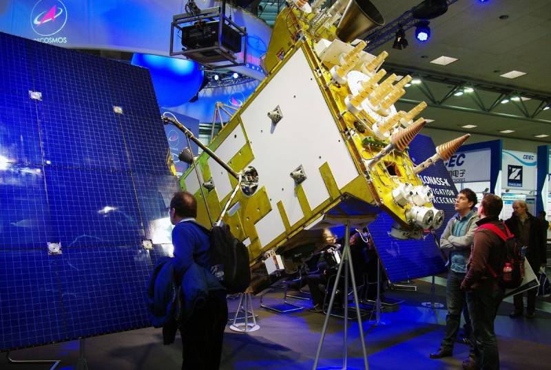
These satellites are built on two main platforms: DFH-3B (operate in the middle Earth orbit), DFH-3 / 3B (operate in the geostationary and geosynchronous inclined orbit). A distinctive feature of satellites is a fairly long service life. High-quality elemental base allows the first to work in space for about 12 years, the second - until 15 years. It is worth noting that at present, Beidou-2 satellites launched into space in 2009 are still in working condition. In this regard, the Chinese satellites are superior to the Glonass-M apparatus with an active life of 7 years and the Glonass-K with the active life of 10 years. At the same time, the oldest of the existing Russian satellites of the GLONASS system has been in orbit since 2006 of the year.
"Beidou" plus GLONASS
As far back as 2015, a Russian-Chinese committee was created to implement a project on cooperation in the field of satellite navigation, which is important for both countries. The committee was created by Roscosmos and the Commission on the Chinese Navigation System. One of the main areas of work of the committee is to ensure compatibility of work and complementarity of the navigation systems of the two countries, as well as cooperation in the application of navigation technologies. Russian-Chinese cooperation on this issue corresponds to the strategic interaction between the two states.
From 28 to 30 on August 2019 in the capital of the Republic of Tatarstan, a regular meeting of the Russian-Chinese Committee for Satellite Navigation took place. The meeting was dedicated to discussing various aspects of the interaction of the national navigation satellite systems GLONASS and BeiDou, the official website of Roscosmos reports. One of the participants in the meeting was Sergey Revnyvykh, who holds the post of Deputy General Director of the Information Satellite Systems company, which is engaged in the production of Russian GLONASS satellites. The participants in the complementarity and compatibility group of the two navigation systems presented the results of the analysis, which confirmed the radio frequency compatibility of the signals of the Russian GLONASS system and the Chinese BeiDou. The experts of the two countries concluded that the signals of the two satellite navigation systems can be used by Russian and Chinese consumers without interfering with each other. In addition, engineers from the two countries confirmed that the Beidou and GLONASS satellite constellations deployed in Earth orbit are compatible. The danger of a collision between Russian and Chinese navigation satellites in Earth orbit is completely eliminated.

Glonass-K spacecraft
It is also worth noting that in July 2019, the State Duma of the Russian Federation ratified an agreement between the governments of the two countries in the field of cooperation and the use of global navigation satellite systems for peaceful purposes, the exchange of experience in the civilian use of satellite navigation systems, the development of navigation technologies using Baidou systems and GLONASS. The very agreement on cooperation in the use of BeiDou and GLONASS navigation systems was signed on November 7 of 2018 in the Chinese capital as part of the 23 regular meeting of the heads of government of the two states. According to the Deputy Prime Minister of the Russian government Maxim Akimov, by the end of the 2019 year, a document should be approved governing the placement of measuring stations in Russia and China.
The measuring stations of the two systems, which should appear in China and the Russian Federation, will allow satellite navigation systems to operate in the two states. The document ratified by the State Duma of the Russian Federation also implies cooperation between the two countries in the creation and serial production of civil navigation equipment using the Beidou and GLONASS systems. The process of developing Russian-Chinese standards for the use of navigation technologies that use both systems is also separately specified. For example, standards for the control and management of traffic flows that cross the border of two countries. According to the Interfax news agency, the navigation data of the GLONASS and Beidou systems will be free for residents of the two countries. The implementation of the agreements made will make it possible to use the Beidou services in Russia by users from China and to receive GLONASS navigation services in China.
Prospects for the Beidou System
China, which claims to be one of the world's major superpowers and has officially become the largest economy in the world, pays much attention to rivalry with the United States. Obviously, this rivalry will intensify in space, where the PRC is implementing a number of ambitious projects today, joining the new lunar race. There is no doubt that soon we will see the rivalry between the Chinese Beidou satellite navigation system and the US GPS global positioning system, which is widely used around the world.

The Chinese press is already writing that the American system will have to make room. Indeed, the Chinese navigation system is newer, the orbital constellation of the PRC is larger, and cooperation with Russia on the issue of satellite navigation will make the Chinese system even more accurate. The real cooperation between Russia and China in the field of satellite navigation, which we have been observing in recent years, will indeed become a challenge for the American GPS system, which for a long time practically did not encounter real competition in the international market. The Chinese Galileo satellite system in China is not seriously considered in many respects due to the recent large-scale malfunction that occurred in July 2019, when all the system's satellites went out of order for several days, and users could not receive a signal from spacecraft. In fact, a large-scale glitch for Galileo is a very unpleasant thing, but not as critical as a possible glitch for GPS or GLONASS, since, unlike the latter two, the European navigation system is not controlled by the military.
At the same time, the United States is unlikely to give up a segment of the international satellite navigation market without a fight. Washington has long been working on developing its global positioning system. 1 October 2019, the press service of the American corporation Raytheon issued a statement on the completion of the process of creating a new generation of satellite navigation and GPS communications system. As noted in the company, the launch of a new generation of the system should occur in 2021 year. A Raytheon report says that the hardware and software of the new system has already been developed, it received the designation GPS OCX. The company's specialists have begun the phase of its testing, as well as integration with the equipment of an already deployed global positioning system.
Information