"They used a whole inflatable army" - Chinese reporters about the stage of the Center-2019 exercises

56
The attention of Chinese reporters covering the strategic command post exercises (SKSHU) Center-2019, which took place in Russia, as it turns out, was also attracted by the actions of Russian engineering units. A report was published on Chinese TV that told about the fulfillment by the military personnel of the 45-th Engineer-Camouflage Regiment (IMP) as part of the exercises set by the command.

"They used a whole inflatable army" - Chinese reporters about the stage of the Center-2019 exercises


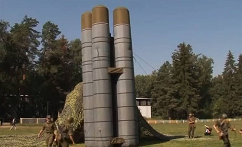
Chinese correspondents, commenting on the actions of Russian troops from the said unit, noted that "the Russians deployed a whole inflatable army at the Donguz training ground in the Orenburg region." It is noted that in addition to real military equipment, a large imitation of it appeared on the training ground.

From the report:

They used a whole inflatable army with an imitation of S-300 anti-aircraft missile systems, tanks T-72 and other military equipment. The arsenal of the 45th camouflage engineering regiment of the Russian Armed Forces also has Su-27 fighters, MiG-31 interceptors, Tochka-U missiles, radar stations - and all this is rubber, inflatable.

Chinese reporters noted that perhaps in vain the Chinese military did not use this method of misleading a potential adversary.

In particular, Chinese experts note that this is “a rather old type of camouflage of real military equipment”:
The enemy’s attention is distracted by the “column” of inflatable military equipment, and at that moment real anti-aircraft missile systems are ready to direct their missiles at his planes - and it’s hard to figure out where the strike will come from.
56 comments
Information
Dear reader, to leave comments on the publication, you must sign in.
  1. +29
    24 September 2019 12: 12
    The Soviet Union, and now in Russia, has a very long tradition in the use of technology models.
    Remember such a movie was a hectic farm?
    1. +7
      24 September 2019 12: 21
      Such inflatable S-400 had to be delivered to Turkey to avoid further problems.
      1. +15
        24 September 2019 14: 17
        Quote: Sky Strike fighter
        Such inflatable S-400 had to be delivered to Turkey to avoid further problems.

        I'm afraid that the Turks would pay for this with inflatable money request
        1. +8
          24 September 2019 14: 41
          I'm afraid that the Turks would pay for this with inflatable money request

          So they take it on credit. And according to the beautiful Soviet-Russian tradition, these debts are then written off ... It’s a pity that it doesn’t work like that with a mortgage.
          1. +1
            24 September 2019 20: 05
            Quote: Letun
            So they take it on credit.

            Turkey acquires four S-400 air defense missile divisions from Russia in the amount of $ 2,5 billion. Turkey will pay 45% of this amount as an advance, 55% will be Russian credit.
            1. 0
              25 September 2019 16: 15
              And yet it is not clear, is it possible that 2,5 billion for Turkey is such a lot of money? I would also understand there, Bosnia or Bangladesh.
    2. +5
      24 September 2019 12: 31
      gorgeous movie! A particularly textured German commander "get away .. bomb !!" when just "kitty-kitty stuck"
      1. +11
        24 September 2019 12: 39
        Inflating the enemy is the main thing, and there it is just a stone's throw before victory.
    3. +3
      24 September 2019 12: 53
      Quote: certero
      The Soviet Union, and now in Russia, has a very long tradition in the use of technology models.
      Remember such a movie was a hectic farm?

      With the help of such inflatable mockups, many victories were completely and completely won, here the main thing is to confuse the enemy, and the infantry will do its job.
    4. +2
      24 September 2019 12: 53
      The economy of Semibaba.
    5. 0
      24 September 2019 16: 14
      Quote: certero
      The Soviet Union, and now in Russia, has a very long tradition in the use of technology models.
      Remember such a movie was a hectic farm?

      That's right, how many lives were saved by Soviet soldiers such deceptive positions and so on ..
      But Moscow was disguised as a masterpiece, they even gave the developer a hero ..
    6. 0
      16 October 2019 17: 46
      Quote: certero
      The Soviet Union, and now in Russia, has a very long tradition in the use of technology models.
      Remember such a movie was a hectic farm?

      I somehow assembled a model of PU OTR from metal sheets. Collected for the first time in my life, all the details were numbered, time, of course, took a lot of ignorance. This was from some sort of old Soviet kit. Even 400 meters without binoculars cannot be distinguished from the original
  2. -11
    24 September 2019 12: 12
    it seems like the Americans’s satellites can give a picture with greater approximation in good weather, the question arises: is there any sense in such inflatable gizmos?
    1. +10
      24 September 2019 12: 16
      Quote: fruit_cake
      it seems like the Americans’s satellites can give a picture with greater approximation in good weather, the question arises: is there any sense in such inflatable gizmos?

      Keyword "sort of like"
      1. -2
        24 September 2019 12: 24
        excluding this possibility would be foolish
      2. +3
        24 September 2019 12: 57
        Quote: barsuk
        Quote: fruit_cake
        it seems like the Americans’s satellites can give a picture with greater approximation in good weather, the question arises: is there any sense in such inflatable gizmos?

        Keyword "sort of like"

        Stripes always write through these words, it cannot be otherwise, because they do not have this.
        1. -3
          24 September 2019 13: 44
          only these minke whales destroyed the USSR, with all subsequent events, who is here?
          1. +13
            24 September 2019 14: 00
            The USSR destroyed us. Stripes could not believe their eyes when this happened.
          2. +1
            24 September 2019 14: 03
            Quote: fruit_cake
            only these minke whales destroyed the USSR, with all subsequent events, who is here?

            So it was their information war that their dollars played a role, not know-how, in the form of scientific achievements of technology and weapons. There is a big difference in this.
      3. +3
        24 September 2019 13: 03
        In-in. In the movie, they can increase the car number. And in life, like a conflict, they show the world the same thing as everything - something not much different from aerial photography (or maybe worse in quality)
    2. +20
      24 September 2019 12: 17
      This is not just inflatable mock-ups, it is a whole complex with imitation of its work. Thermal signature, etc.
    3. +8
      24 September 2019 12: 18
      Their "big zoom" will somehow prevent them from submitting a photo in the case of the downed MH17.
      1. -7
        24 September 2019 12: 23
        how do you imagine it?
    4. KCA
      +5
      24 September 2019 12: 30
      Satellites have the ability to fly in orbits, flying over a certain point once an hour and a half, there are geostationary satellites, but they have very low resolution accuracy, a range of 40 km is not small at all, and yes, these are not inflatable balls, these are complexes with simulations and thermal and radar signature
    5. 0
      24 September 2019 12: 50
      root words sort of и in good weather therefore, no one does not get up with anyone about this.
    6. +6
      24 September 2019 12: 50
      Quote: fruit_cake
      it seems like the Americans’s satellites can give a picture with greater approximation in good weather, the question arises: is there any sense in such inflatable gizmos?

      These inflatable models are not only visually similar to the originals, but also give out exactly the same radiation parameters as the real technique. No satellite will see what really is there. We already have two armies of such "restless farms" from the film of the same name with Zharov.
    7. -3
      24 September 2019 15: 00
      Weather is one thing.
      But there is a concomitant - fixing the operation of systems.
      And this is radiation, and thermal background, and much more.
      Inflatable layouts are dead.
      And the satellite sees it.

      My friend used to serve in the sniper unit and talked about the fact that you can also detect a person in a shelter from a satellite.
      And then mortars will hit there (it was in Yugoslavia).

      Creating layouts and providing them with additional naturalness is both difficult and expensive.
      1. 0
        25 September 2019 20: 21
        More expensive than making a real technique? As for Serbia, the brilliant American satellites and locators were easily bought with simple microwaves and the same inflatable and plywood models. Tanks left Kosovo with virtually no loss ..
        1. 0
          25 September 2019 21: 04
          On the street 2019 year.
          And in Yugoslavia events unfolded in 1999.
          20 years have passed.
          Technology does not stand still.
          Are developing.
          An inflatable model, it seems to me, can be distinguished from a "live" tank.
          Of course, substitutes for women are now making them "very human", but the sensations are probably not like that! hi
          1. 0
            26 September 2019 11: 14
            "It seems", "probably" ... The arguments are such that you can't argue! And technology is improving in the field of imitators. Suddenly.
            1. 0
              26 September 2019 12: 36
              Just a note.
              Engaged in certain scientific activities, you develop a habit - ALWAYS to say that the opinion I expressed is purely personal.
              And I do not impose it on anyone.
              If you were my student and would study my work, then I would demand from you not to share my point of view, but to strictly follow it!
              Catch the difference, sir?

              And so there is a field for maneuver.
              Suddenly, an upset stomach occurs, with subsequent emotional outbursts and geographical throwings.
      2. 0
        16 October 2019 17: 54
        Quote: demo
        Weather is one thing.
        But there is a concomitant - fixing the operation of systems.
        And this is radiation, and thermal background, and much more.
        Inflatable layouts are dead.
        And the satellite sees it.

        My friend used to serve in the sniper unit and talked about the fact that you can also detect a person in a shelter from a satellite.
        And then mortars will hit there (it was in Yugoslavia).

        Creating layouts and providing them with additional naturalness is both difficult and expensive.

        Did he have a satellite sight? The fact that the resolving ability is very good I read in the technique of youth, there was everything with a photo.
    8. +1
      24 September 2019 21: 36
      Quote: fruit_cake
      it seems like the Americans’s satellites can give a picture with greater approximation in good weather, the question arises: is there any sense in such inflatable gizmos?

      So they, it’s like, and the Patriots are knocking everything down ...
    9. 0
      26 September 2019 07: 26
      It has. satellites have really good resolution and you can see people.
      but it’s very difficult to tell exactly. and with the right camouflage is almost unrealistic.
      here is an example of google maps. people and cars are visible. but you can’t tell from a fake.
      1. +1
        26 September 2019 07: 51
        And who told you that on Google maps, you must have satellite images?. There, mostly video from drones from a height of 200-300 meters is used
        1. 0
          27 September 2019 01: 50
          WorldView-3 - commercial satellite designed to observe the earth. At the time of launch, the WorldView-3 satellite had the highest spatial resolution among all commercial remote sensing satellites: up to 31 cm in panchromatic, 1.24 m in the multispectral and 3.7 m in the middle infrared range.
          25.02.2015, USA | DigitalGlobe, an American operator of civilian Earth remote sensing satellites, has finally received approval from the US government to sell high-resolution images (up to 30 cm) to everyone. Until yesterday, a limit of 50 cm was set, and everything above it was available only to US government agencies. “Today, we are marking an important milestone for our customers, who will now receive photographs of such a level of image quality that were never before available for sale by commercial satellite providers,” DigitalGlobe shared the good news in his press release.

          The resolution of the satellites is quite enough to find, but not quite to determine the fake.
      2. +1
        26 September 2019 11: 16
        We must also mask the real technique for fakes!
        1. 0
          27 September 2019 01: 51
          under a camouflage net, and so it’s difficult to make out, an inflatable or real object
  3. +3
    24 September 2019 12: 33
    Normal work of special units! Everything in the subject, if done wisely.
  4. +5
    24 September 2019 12: 37
    It's nice to see how our military leaders pay great attention to the issues of military cunning - honor to them. For overseas "warriors" these issues are fixed in the foundations of the strategy and planning of the database, and it is very important that those who now serve with us have this topic in one of the first places. Thanks.
    1. +1
      26 September 2019 00: 55
      I read about a funny combat episode on the Western Front during World War II. The Germans built plywood models of technology from plywood = tanks, planes, artillery, a false line of defense, in the hope of diverting the attention of the Allies. The Americans managed to open the plan of the Wehrmacht. They struck a fake ... with wooden bombs. Here is a sense of humor in wartime.
  5. +3
    24 September 2019 13: 51
    Quote: fruit_cake
    it seems like the Americans’s satellites can give a picture with greater approximation in good weather, the question arises: is there any sense in such inflatable gizmos?

    There is no such possibility. If we focus on cinema, there are more realistic scenes where a high-resolution picture is given from a drone, it is much closer to reality. From space at this stage in the development of technology, this is impossible.
    1. -1
      24 September 2019 14: 09
      Back in the eighties, there was a "satellite image" with a readable newspaper headline. The usual commercial Google satellites now give almost a car number to consider. Another thing is that satellites do not always hang over the terrain, and no one will let the drone close, so there is still some sense in these models.
      1. +1
        24 September 2019 21: 40
        Quote: puzoter
        Ordinary commercial Google satellites now provide almost the number of a car to consider.

        31 cm per pixel. Especially you do not read the headlines or the number of cars. Of course you will see the car itself ... under a favorable set of circumstances ... Yes
        1. 0
          25 September 2019 12: 16
          Well, a little exaggerated. So after all, civilian satellites can also be sued for clearer pictures.
          1. +1
            25 September 2019 14: 11
            Quote: puzoter
            So civil satellites

            Everything is much more complicated here. Let's go from the opposite.
            Of interest is not only photographing the surface of the Earth from space, but also photographing the secret satellites themselves from the Earth. This task requires special telescopes, with a very fast guidance system, which allows you to track a spacecraft flying quickly through the sky. The largest such specialized telescope was built in Hawaii: it is called AEOS (Advanced Electro


            This telescope weighs 75 tons and has a 3.67-meter main adaptive mirror with 941 active correctors. In addition, it is important to note that the telescope is installed in one of the best places for astronomical observations - at an altitude of 3 km above sea level. According to open sources, the telescope is capable of observing spacecraft and ballistic missiles using optical and infrared cameras. Ideally, this telescope was supposed to photograph low-orbit satellites with a resolution of a centimeter per pixel. However, its unveiled features were much more modest. The fact is that in 2003 a sad event occurred - the Columbia spacecraft crashed. The catastrophe happened due to damage to the wing edge by pieces of ice at launch. Already a quick study of the launch record made it possible to suspect that something irreparable happened. In this regard, NASA asked the military to make as detailed as possible pictures of the spacecraft in space in order to assess how dangerous its damage is to enter the atmosphere. As a result, not reconnaissance satellites were involved, namely the AEOS telescope. The images were indeed taken, and no damage to the spacecraft was found on them. After the disaster and its investigation, these pictures were published:


            According to reports, the resolution of these images was 6-8 inches, or 15-20 centimeters per pixel. This value definitely spoke of the hard limit of optics in observations across the entire earthly atmosphere. Especially considering that space telescopes are much smaller in size and on-board power capabilities. Also, ground-based telescopes are usually located in ideal places for observations, and satellites for optical observations mainly have to photograph land areas near sea level, where the maximum thickness of the earth's atmosphere is observed.

            The size of the shuttle, I think there is no need to bring.
            1. 0
              26 September 2019 11: 12
              It is not at all a fact that this picture is exactly what they say about it. Journalists most likely showed it not in the maximum resolution, because the maximum characteristics of such a telescope are probably classified. Anyway, do not be lazy, open Google map Washington, in the end. With proper dexterity in the pictures, you can determine the make of the car. Roughly the same 15 20cm per pixel or less. And I repeat this again - civil technology on private satellites, and most likely limited, so as not to be blamed for the invasion of privacy. For the military, you can safely multiply at least 10-15 - you get a centimeter - one and a half per pixel.
              1. 0
                26 September 2019 23: 11
                Quote: puzoter
                open google maps

                Not everything is so simple (s) ... Yes
                Everyone saw the "Satellite" mode in Google Maps. It turns out that 15 years ago serious controversy flared up around this word. First, photos for the service were provided by Keyhole, which produced aerial photography terrain.
                Therefore, many developers favored the honest name of the Aerial Photography feature. But this word did not fit on the button. There was another suggestion: “Sputnik”. Although this is a lie from a technical point of view, it fits well with the design, says Taylor. ...
                ... Fortunately, Taylor took the risk of disobeying the boss, because Sergei’s proposal seemed completely absurd. On his initiative, the aerial photography mode was still called “Sputnik”.

                Recently, Google noted that its online services are popular in many respects due to their regular updates. So, the popular map service Google Maps received its update with 45-degree images of another 24 cities. Thus, the corporation has already released the second aerial photography update in 2012. Most of the cities are in the USA, but there are also a few from Europe, South America and Brazil. Google noted that the second update for Google Earth and Google Maps, containing 45-degree images, includes 17 US cities and 7 cities from other countries. One of the most interesting places, the images of which were updated in the map service, are the Brazilian Porto Alegre and German Ulm.

                Recall that about a week ago, Google updated satellite images in Google Maps for more than 120 countries, and also added aerial photographs for some cities.

                Materials from Habr and 3Dnews.
    2. 0
      25 September 2019 20: 23
      Right I saw this picture from the drone. People can be recognized.
  6. +4
    24 September 2019 15: 21
    Is this some kind of cheating ?!) laughing
  7. 0
    24 September 2019 15: 32
    But interestingly moving layouts are. Well, so that the same Triumph would be with the missiles raised and then with the missiles down. Or so that the tank moved around the area.
    1. 0
      25 September 2019 20: 25
      Sherlock Holmes, using Miss Hudson, achieved this effect in the story "Empty House". The imitation wax doll moved and rustled the newspaper.
  8. 0
    24 September 2019 18: 13
    Quote: major147
    Quote: Sky Strike fighter
    Such inflatable S-400 had to be delivered to Turkey to avoid further problems.

    I'm afraid that the Turks would pay for this with inflatable money request

    Now physical and legal entities do not give real money to individuals. You receive the goods, and give the colored paper. The transaction is not completed, you must remain. And debt grows and grows. The United States has won some trillions of such. Money is a promise to pay.
  9. 0
    25 September 2019 04: 03
    Quote: fruit_cake
    it seems like the Americans’s satellites can give a picture with greater approximation in good weather, the question arises: is there any sense in such inflatable gizmos?

    laughing They will do it in such a way that you cannot distinguish it from a real one; laughing laughing
  10. 0
    25 September 2019 04: 08
    War is a way of deception [Therefore, if you can do anything, show the enemy that you cannot; if you use anything, show him that you do not use it; even if you were close, show that you are far away; even if you were far away, show that you are close; lure him with profit; get him upset and take him; if everything is complete with him, be ready; if he is strong, evade him; causing anger in him, bring him into a state of frustration; assuming a humble appearance, call forth self-conceit in him; if his strength is fresh, tire him; if his warriors are friendly, disconnect; attack him when he is not ready; speak when he does not expect laughing laughing Sun Tzu - the great Chinese strategist and thinker of the VI century BC. e. The author of the famous treatise on the military strategy "The Art of War", written at the request of the request of Prince Ho Lu. Wei Lao Tzu wrote: “There was a man who had only 30 thousand troops, and no one in China could resist him. Who is it? I answer: Sun Tzu. " laughing
  11. 0
    25 September 2019 07: 53
    Deception and "cheating" of the enemy are common methods of armed struggle.