Battle geologists. U.S. Geospatial Intelligence

13

Look through the earth


Geospatial information for the army is currently becoming increasingly important. In all countries, defense departments understand that promptly providing troops with a description of the terrain and geodetic parameters can decide the outcome of the confrontation. Since the 1996 year, the National Geospatial-Intelligence Agency (NGA), headquartered in Springfield, Virginia, was created to collect, analyze, and transmit similar information to the troops in the United States. The new structure has replaced the National Agency of Images and Cartography (NIMA). The circle of the main tasks of the structure very well illustrates the motto of the office:
"Explore the earth ... Show the way ... Know the world ...".


Battle geologists. U.S. Geospatial Intelligence

Emblem nga


Specialists from Springfield study not only the structure of the surface and near-Earth space, but also conduct active subsurface exploration. Currently, the head of the service is Robert Cardillo, an absolutely civilian person with a degree in art from Cornell University. According to reports, Cardillo turned out to be a good analyst of species intelligence at NIMA, which allowed him to significantly advance in service. Cardillo reports directly to the Under Secretary of Defense for Intelligence and the Director of National Intelligence.


The predecessor of the National Agency for Geospatial Intelligence - the abolished National Agency for Imaging and Cartography (NIMA)


The NGA service has the status of a strategic agency and is one component of a large US intelligence pool, which includes at least 17 agencies at various levels. In particular, the tasks of the NGA largely overlap with the functionality of the US National Aerospace Intelligence Agency and, in part, with the CIA itself.
More than 35 million cards in print and digital versions are created annually based on NGA intelligence and analytical work for the needs of the US Department of Defense. For work “in the field”, geospatial intelligence centers have been created that provide the center with the necessary information. In addition, such centers located at US military presence facilities around the world coordinate the communication of the military command with the NGA head office, and also compiles three-dimensional maps of the area. Each such center of “combat geologists and cartographers” consists on average of 30 specialists.


Former Secretary of Defense Jimm Mattis (center) with Director of the National Geospatial Intelligence Agency Robert Cardillo (right) and Deputy Director Susan Gordon (left). The photo dates from August 2 to 2017 of the year. Agency Headquarters in Springfield, Virginia


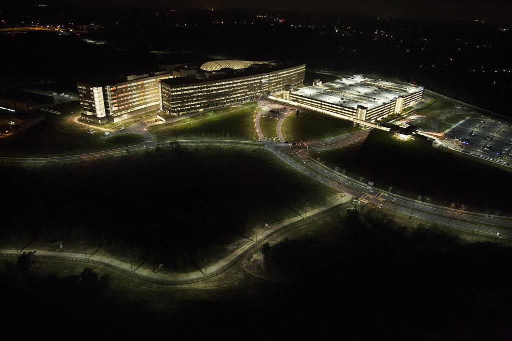
NGI headquarters resembles a hypermarket


The conflict in Syria has become a good testing ground for the NGA to break into new items - subsurface sounding systems. This technique was originally intended for use on the US-Mexican border to detect underground tunnels for drug trafficking and illegal migration. But even in Syria, the militants very successfully used dug multi-kilometer moves both for organizing attacks and retreats, storing equipment and ammunition, and for undermining especially important enemy targets. The identification of such wormholes has become one of the main tasks of US HSPAs in Syria. Remote subsurface sounding also allowed the Americans to declare in 2017 that underground storage facilities for chemical weapons.

Weapons and NGA communications


In the tactical reconnaissance unit, NGA experts use the Husky Visor 2500 heavy mine detector equipped with four Ground Penetrating Radars capable of probing the subsurface layer to a depth of 1,8 meter. In addition to the machine detecting, marking and neutralizing mines, it is able to create a three-dimensional picture of the underworld, highlighting suspicious voids. Visor 2500 is actively used by NATO countries, in particular, Spain has purchased a batch of machines for work in Afghanistan. Turkey, which plans to use cars in the Syrian conflict, is also interested in buying wheeled radars.
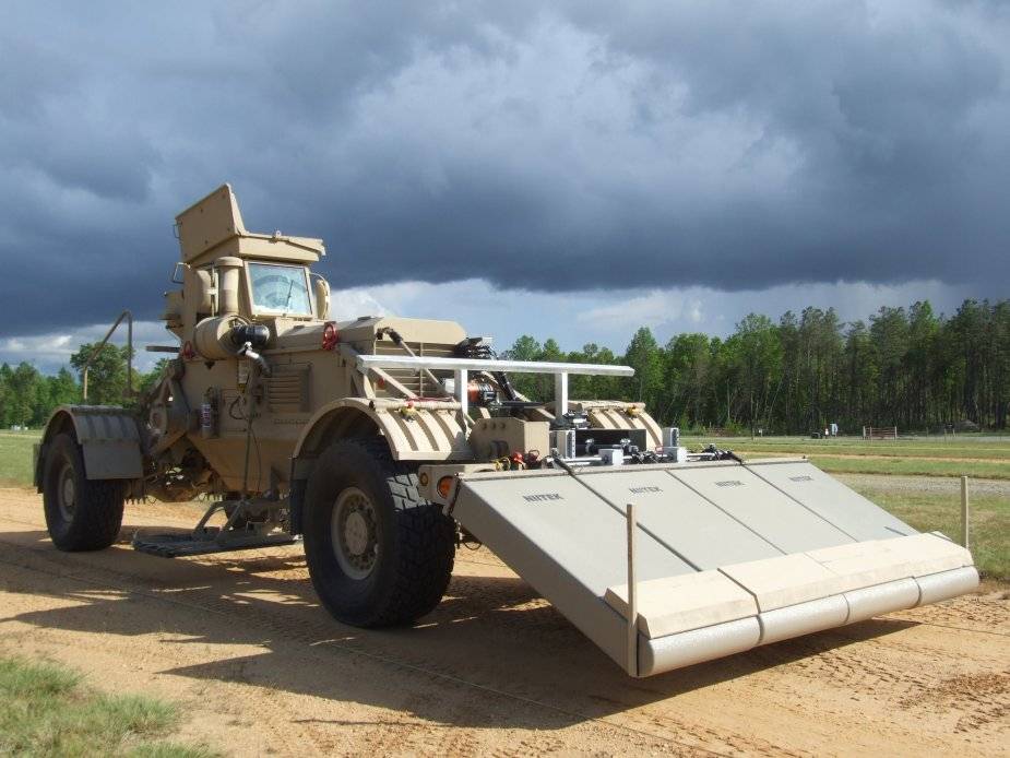

Husky Visor 2500


But the Husky Visor 2500 is a large and bulky machine that is not able, for example, to work in narrow streets. In addition, she is often attracted to the main job - the search for mines. The R2TD (Rapid Reaction Tunnel Detection) compact subsurface radar was developed directly for the discovery of underground tunnels by the US Army Engineering and Research Center from Vicksburg, Mississippi. It can be used both in a wearable version and installed on light equipment. The device has several sensors, allowing not only to scan the thickness of the earth with a radar, but also to determine acoustic waves, heat sources and seismic activity. In addition, R2TD “sees” underground power lines and various communication lines. In the open press, there are still no tactical and technical characteristics of a compact GPR, although it has been used in the army since 2014 of the year. It is only indicated that the manufacturer regularly updates the software of the device, since terrorist organizations constantly change both the configurations of tunnels and the ways of laying them. First of all, the Americans equipped with similar technology the locations of their troops in Afghanistan and Syria. They have a rich and full of blood story the fight against the underground warriors, which began back in Vietnam. In this regard, many American military camps are surrounded by passive soil linear sensors warning of suspicious seismic activity. Even a whole class of new “underground hunter” specialists has appeared in the US Army. Surely, in the near future we will see another patriotic film about them.


Subsurface Radar R2TD


For intelligence purposes, NGI adapted the modern BuckEye complex, equipped, in addition to the optical channel, with a laser radar or lidar of the LIDAR Optech ALTM 3100 model. This unique geodetic complex can be placed both on UAVs and helicopters, providing the military with a detailed three-dimensional map with a resolution of 3 cm. Such devices have been tested and even serially produced by automobile concerns for autopilot systems for several years. Lidars are extremely expensive, but at the exit they give an excellent picture. True, they are quite dependent on weather conditions, so they are often duplicated by a radar observation channel. Americans with the help of BuckEye have already "shot" a decent part of the territory of Afghanistan, Syria and Iraq.


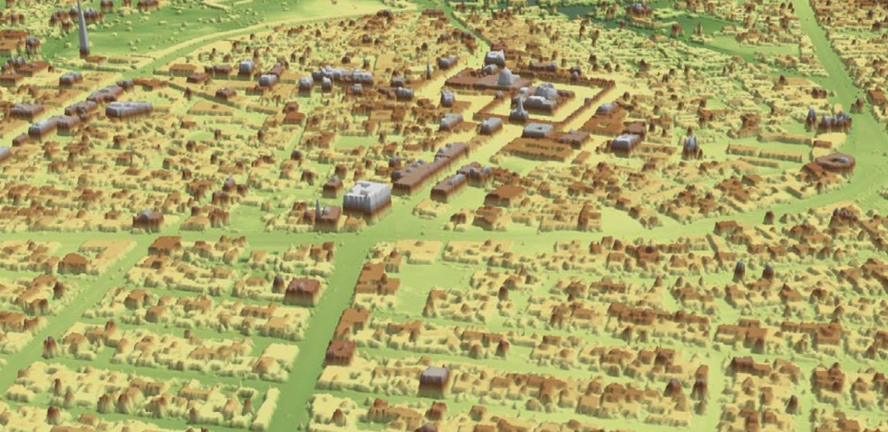
In the photo, a three-dimensional map of the Iraqi city of Samarra, obtained using the BuckEye complex


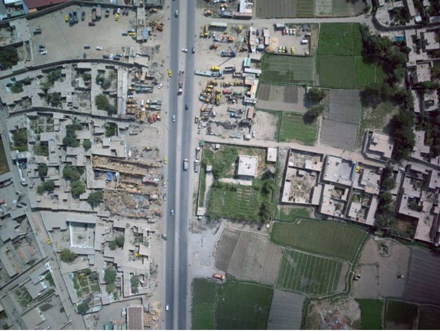
Photo of Kabul with a BuckEye-equipped UAV


The Americans are actively using expensive reconnaissance equipment - in total, since 2007 in the interests of the US Army, accurate three-dimensional maps of the territory have been collected with a total area of ​​more than 300 thousand square meters. kilometers. In Afghanistan alone, at least five aircraft operated with BuckEye. The plans for the modernization of the installation of a sensitive infrared sensor for accurate positioning of equipment and manpower of the enemy.

One of the most important areas of NGI's work is the expansion of the controlled area of ​​the globe through the involvement of partner countries. So, since 1956 of the year Five Eyes (FVEY) has been functioning, which includes intelligence services of five countries - the USA, Great Britain, New Zealand, Australia and Canada. This is a kind of global intelligence service that Snowden described as "a supranational intelligence organization that does not obey the laws of its countries." Inside FVEY, among other things, they exchange geodetic data, and also involve third countries in cooperation. As a result, all information naturally accumulates in NGI analytical centers and is used in the interests of the US Department of Defense.
  • Evgeny Fedorov
  • assets.shephardmedia.com armyrecognition.com en.wikipedia.org
Our news channels

Subscribe and stay up to date with the latest news and the most important events of the day.

13 comments
Information
Dear reader, to leave comments on the publication, you must sign in.
  1. +1
    22 August 2019 18: 46
    [quote] [/ quote] Scanning and tracking is the task of all special services! And who is lucky only time will show!
  2. +1
    22 August 2019 18: 50
    What can I say, cards have always been a critical link in preparing for hostilities. As I understand it, if in addition to satellites, Americans actively use various UAVs, then the resolution and characteristics of satellite-based surveillance equipment are not always enough.
    In our country, as I heard, satellites always lagged behind American vehicles in their capabilities.
    I hope we will have our own or, most likely, purchased equipment for heavy drones that, like, are already being tested
  3. +16
    22 August 2019 19: 25
    "Horses mixed in a bunch, people ..."
    To begin with, the National Agency for Geospatial Intelligence has nothing to do with geology and there are no combat geologists there.
    Military geology is a separate component of military science that studies the geological structure of the terrain and hydrogeological conditions, based on the requirements of engineering support for military (combat) operations of troops and forces, justification for the placement of various fortifications, airfields, military roads and bridges, military hydraulic and other structures , organization of water supply to troops, assessing the patency of the terrain by various types of troops, as well as the search and exploration of groundwater, building materials and strategic raw materials. Military-geological services or structures similar to them in terms of functions deal with these issues.
    In the United States, such a structure is the United States Geological Survey (USGS), which belongs to the Department of the Interior. Motto: "Science for a Changing World".
    Further. The National Geospatial Intelligence Agency is not involved in the search for mines and tunnels of terrorists and has nothing to do with it. This is done by army experts.
    Now about such a formidable term as geospatial intelligence. Here it is necessary to clarify one more term - geographic information system (geographical information system, GIS). This is a system for collecting, storing, analyzing and graphically visualizing spatial (geographical) data and related information about the necessary objects.
    To solve the problems facing this very GIS there is a geospatial analysis - this is the process of searching for spatial patterns in the distribution of geographic data and the relationships between objects.
    The most common tasks of geospatial analysis are as follows:
    analysis of the location of objects - search where objects are located (Mapping where things are);
    analysis of the distribution of numerical indicators - identifying where more, (Mapping the most and least);
    building density maps - mapping density (Mapping density);
    searching for objects inside the area - finding what's inside;
    weapon analysis - Finding what's nearby;
    spatial change analysis - mapping changes
    For example, mapping the density of place names to study the population distribution of the Lower Kolyma region of the Sakha Republic is also a geospatial analysis that allows you to establish the relationship between the density of toponyms and the population of the studied area.
    The military also uses geospatial analysis and its methods for their specific purposes. Now it will be geospatial intelligence.
    This is exactly what the National Geospatial Intelligence Agency does.
    1. +5
      22 August 2019 22: 06
      Undecim

      brilliant comment.

      I, as a graduate of Geofak, was pleased to read. (Although I am not a geologist, but a geographer.)
      In general, the mapping of our planet (all surfaces, spheres and cavities, etc.) never ended and is developing rapidly. We caught the planet in a grid and now achieve accuracy in drawing it up to the photograph on the maps.
      The value of rial time cards is invaluable to the military.
      By the way, the military without geologists and cartographers as without hands.
      Although the main consumer is civilian.
      Give military specifics ..
      1. +6
        22 August 2019 22: 13
        Yes, just the abundance of materials from the authors, completely far from the topics to which they write, is already tired.
    2. +1
      24 August 2019 09: 43
      Nice post.
      I will add that the term "Intelligence" translated simply as "intelligence" means immediately to lose the most important element of the semantic content of this term. Unfortunately, there is no Russian-language analogue, so it is necessary to explain in detail. Intelligence is, first of all, informational and intellectual support that helps to perceive, understand, feel, represent, etc. the like. Generalissimo Suvorov called it "the eye".
  4. 0
    22 August 2019 19: 51
    The USA is a predatory country in every way. Information in our time costs a lot of money, and they receive it free of charge by "friendship".
  5. +2
    22 August 2019 21: 38
    Damn, what a cool office in the photo, Americans are able to create conditions for their employees, but the monstrosities to the left of the mettis are terrible as an atomic war, sorry for the bad man, but seriously, but GIS is very actively used in our military and civilian sectors for a very long time
    1. 0
      24 August 2019 09: 48
      And I'm not thrilled with a building made of steel skeleton and glass instead of walls. But cheaper in construction than normal - yes.
  6. +1
    22 August 2019 22: 47
    Who owns the information, he owns the world ... And GIS is the most powerful tool in the world for processing spatial data. Money in that steppe was nemeranno been dumped back when Comrade Reagan. And not in vain. There are rumors that the analysis of the collected statistics by the Americans in the GIS led to the collapse of the union. There is such a private office with a show: ESRI (decryption-institute for environmental research). Then they were attracted.
  7. 0
    23 August 2019 15: 03
    Quote: Undecim
    Military geology is a separate component of military science that studies the geological structure of the terrain and hydrogeological conditions, based on the requirements of engineering support for military (combat) operations of troops and forces, justification for the placement of various fortifications, airfields, military roads and bridges, military hydraulic and other structures , organization of water supply to troops, assessing the patency of the terrain by various types of troops, as well as the search and exploration of groundwater, building materials and strategic raw materials. Military-geological services or structures similar to them in terms of functions deal with these issues.

    And who dashed the analysis of the torpedoing of the fault to Sakharov?
    1. 0
      24 August 2019 09: 45
      Just the scientists who did this.
      And here - an organized structure, department, with the staff and budget directly involved in this.
  8. 0
    1 October 2019 15: 10
    Well, five countries is loud. If you round, you get two countries: the United States and the United Kingdom (Australia, Canada, New Zealand).

"Right Sector" (banned in Russia), "Ukrainian Insurgent Army" (UPA) (banned in Russia), ISIS (banned in Russia), "Jabhat Fatah al-Sham" formerly "Jabhat al-Nusra" (banned in Russia) , Taliban (banned in Russia), Al-Qaeda (banned in Russia), Anti-Corruption Foundation (banned in Russia), Navalny Headquarters (banned in Russia), Facebook (banned in Russia), Instagram (banned in Russia), Meta (banned in Russia), Misanthropic Division (banned in Russia), Azov (banned in Russia), Muslim Brotherhood (banned in Russia), Aum Shinrikyo (banned in Russia), AUE (banned in Russia), UNA-UNSO (banned in Russia), Mejlis of the Crimean Tatar People (banned in Russia), Legion “Freedom of Russia” (armed formation, recognized as terrorist in the Russian Federation and banned)

“Non-profit organizations, unregistered public associations or individuals performing the functions of a foreign agent,” as well as media outlets performing the functions of a foreign agent: “Medusa”; "Voice of America"; "Realities"; "Present time"; "Radio Freedom"; Ponomarev Lev; Ponomarev Ilya; Savitskaya; Markelov; Kamalyagin; Apakhonchich; Makarevich; Dud; Gordon; Zhdanov; Medvedev; Fedorov; Mikhail Kasyanov; "Owl"; "Alliance of Doctors"; "RKK" "Levada Center"; "Memorial"; "Voice"; "Person and law"; "Rain"; "Mediazone"; "Deutsche Welle"; QMS "Caucasian Knot"; "Insider"; "New Newspaper"