Russian intelligence officers master GLONASS

13
Russian intelligence officers master GLONASS

The scouts of the Russian military base stationed in Abkhazia are mastering a portable communications complex with the built-in GLONASS system, the press service of the Southern Military District reports.

"Military personnel of the intelligence units of the Russian military base in Abkhazia have begun field training in mountainous wooded areas at the Tsabal proving ground, where they work out tactical techniques using modern topographic control and navigation systems, as well as improved communications and surveillance," the press said. - services.

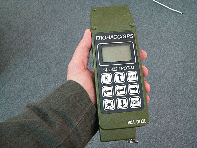
It clarifies that the special attention of intelligence officers is paid to the development and practical application of the portable complex of communications "Strelets", which allows you to transfer coordinates using the integrated GLONASS systems.

In addition, the press service added that during the training the scouts fulfill the standards for firing at targets from the spot and in the movement from the 12,7-mm NSVS machine gun mounted on the KAMAZ-43269 “Dozor” armored reconnaissance vehicles.
13 comments
Information
Dear reader, to leave comments on the publication, you must sign in.
  1. +1
    12 June 2012 11: 42
    In the article, the device is called "Sagittarius", and in the photo - "Grot-M"
    Misunderstanding?
    1. Alexey Prikazchikov
      +1
      12 June 2012 16: 37
      Here he is, Grotto M
      1. +2
        12 June 2012 18: 48
        You are shown the next generation, in the previous article

        In the photo above are two GLONASS / GPS navigators of the Scientific Research Institute of Space Instrument Engineering: on the right - the previous generation 14Ц822 “Grot-M” equipment, on the left - a new sample, which has the same name as the previous one - “Grot-M”, but is the deepest modernization of the younger brother.

        The first "Grotto", released in 2003, is in service with the Russian army, as well as several countries in Africa and Latin America (the navigator’s menu has English, French and Spanish localizations) and has an circulation of about 10 thousand copies. In our armed forces it is used mainly by the commanders of artillery units, reconnaissance, mountain arrows and special forces. According to the state, it is necessary to have him in the motorized rifle battalion, as well as company tactical groups operating in isolation from the main forces.
        The case of the navigator is made of a single bar of aluminum by milling, which caused a high strength of the product, but at the same time significantly weighed it (the weight of the device was 800 grams). Since the device was originally intended only to determine the coordinates and solve problems in artillery, he received a small screen and did not support the display of maps. For convenience of work in a hard frost, when hands are in gloves, the navigator was equipped with large buttons that the end users liked very much - the military
        2003 Grot-M battery

        2011 Grot-M battery

        The navigator maintains being under water at a depth of 1 meter during the day and can then work.
        "Grotto" can be connected to networks with low voltage (from 10 to 30 volts), which allows you to charge it from the onboard network of cars and armored vehicles. It is possible to charge battery packs both in the device itself and in a separate charger.
        At the time of communication with the developers (August 2011), the power consumption of the navigator produced by the 130 nm technical process was 1.05-1.1 W (at the peak of work up to 1.2 W), but now there is updated data on the site that it is no more than 1 W, which means that the expected transition to the 110 nm process technology took place.
        It should be noted that the power consumption of devices based on GLONASS will always be more than similar devices based on GPS, since the domestic navigation system uses a wider range of frequencies. A wide channel is harder to suppress by electronic warfare, but this plus is being exchanged for higher power consumption.

        The navigator can work simultaneously with 32 satellites, which greatly improves the positioning accuracy. It (accuracy) depends on many factors (the number of satellites, the terrain, etc.) and for the "Grotto" is 10 m (operation mode, when interaction is only with satellites), which is comparable with similar indicators of the American military navigator DAGR. The differential mode is also implemented in the domestic navigator, which allows, using base stations, to increase the positioning accuracy to tens of centimeters.
        "Grot-M" with an external navigation antenna. The antenna has a magnet and can be used when driving in a car.

        At the request of the customer it is possible to install a slot under the SD-card flash memory, but the military is not asking for such an opportunity. The internal memory of the device itself is 256 megabytes.
        The favorite question of all readers was asked by me: "Whose production is the electronic component of the navigator?". The chip is entirely developed in the enterprise, except for the processor core, which was purchased under license. Digital circuit design, topology - all domestic, but the physical manufacturing - China, Taiwan. The installation of the board again takes place with us. Displays are also purchased abroad, because Belarusian developers (alternative to foreign countries) offer models with high power consumption, weight and cost.

        Navigator allows you to record the route and show it on the background of the map. Maps, routes can be poured into the device and removed from it through the USB interface (the port for USB, RS-232 and RS-485 is one, the splitter is included). Included with the product is software that allows the end user to match the navigator with operating systems based on Linux and Windows. It is assumed that, if desired, the user will be able to install any cards from third-party developers into the Grotto, using a special converter from the software bundle.
        Navigator can solve service tasks that are necessary for the needs of gunners:
        - the coordinates of the point to be fired are determined by given coordinates, distance and azimuth;
        - the distance and azimuth between them is determined by given two pairs of coordinates;
        - coordinates of the third point are determined by the coordinates of two points and the angle between them;
        - measurement of the direction angle, etc.
        It is possible to recalculate longitude and latitude into Gauss-Kruger coordinates and back.
  2. Hey
    +4
    12 June 2012 12: 19
    Hope for Glonas, but don’t forget about Caspus and the map.
  3. Korvin
    0
    12 June 2012 12: 54
    The grandmother recalls)) Oh, and when it’s not just a scout but an ordinary soldier, we’ll already learn how to use orientation systems from us ...
  4. Neighbor
    0
    12 June 2012 13: 16
    Finally - the quality communication began to flow into the troops !!! Yes
    I hope that it will never happen again like in the events of 08.08.08/XNUMX/XNUMX. am
    When our troops were forced to keep in touch and coordinate their actions by cell phones to their personal and pre-home radios. belay sad
  5. Dustcoll
    +3
    12 June 2012 13: 53
    Comrade Commander, when the cap says I will call you. So one tanker was talking about a headset. Explain to the soldiers where the north is, so that they do not look for moss in the south. laughing
  6. sergey261180
    0
    12 June 2012 13: 56
    I wonder how much this crap is worth?
  7. 0
    12 June 2012 14: 23
    the armor-piercing car, it is necessary to put the same model in a civilian design, for hunting, fishing, tourists
  8. DERWISH
    +1
    12 June 2012 14: 37
    useful thing !!! it would work only if we had a radio station sq. 147 portable all the rules except the connectors and batteries break and practically run out in an hour and it cost as much as a Lada car at that time about 10 rubles 000 there were 1987 straight visibility and problems are the same meaning not only in convenience the most important thing is performance in any conditions
  9. bamboo
    +1
    12 June 2012 15: 00
    the news is good, but such a pancake is a colossus, and the batteries for the Germans carry the second calculation in suitcases))))) laughing (joke)
    1. Alexey Prikazchikov
      0
      12 June 2012 16: 38
      Yes damn they showed junk
  10. Shura
    -3
    13 June 2012 01: 26
    Ha ha ha! You can see right away that our work, the design is still, so to speak, retro. How many years have been puffing over this glonass, how much money has been laundered - it’s just horrible, even if it would have looked humanly.
  11. +3
    13 June 2012 08: 24


    Here is the American military GPS, well, it doesn’t look much better) These are military things, they should be reliable, not beautiful.