As the Portuguese and Spanish "predators" divided the world
Since 1444, the Portuguese sent whole flotilla to Africa for "live goods." People were hunted like wild animals with specially trained dogs.
Portuguese expeditions
The Portuguese prince Enrique did not participate in sea expeditions, but by constantly encouraging the navigators and patronizing the explorers of the new lands, he received the name "Sailor", under which he entered history.
Cape Non (Nun) on the west coast of Africa has long been considered the fateful boundary for all navigators. The very name of the cape - “Non”, in Latin means “no” - speaks of how he enjoyed notoriety. In 1419, this cape was rounded off by two Portuguese noblemen, João Gonçalu Sarku and Tristan Teischer, sent by Prince Henrique. A violent storm carried their ship far into the open sea, where they discovered an island called Porto Santo by them. Having surveyed the island, the travelers returned to Portugal. A year later, they returned and noticed another wooded island, which they called Madeira - “Wooded.”
After that, 15 years passed before the Portuguese were able to go around Cape Bochador, guarded, as they said then, by strong sea currents and winds. Only in 1434, captain Gil Eanish, a brave and ambitious man, passed by this cape after the third attempt. The feat of the captain was then compared "with the most glorious exploits of Hercules." Encouraged by this success, Antan Gonçalvesh in 1441 year and Nunyu Tristan in 1444 year progressed further south. The first brought some golden sand from the banks of the Rio de Oro, and the second reached the mouth of the Senegal River, where he captured several Negroes, whom he brought to Lisbon and served at a very high price. That was the beginning of the Negro trade, a trade that literally devastated the Black Continent, which covered the Europeans with shame for four centuries. Tens of millions of blacks were killed and sold into slavery, died from hunger, exhaustion and disease, from inhuman conditions during transportation and slave labor.
Since the 1444 year, the Portuguese have sent entire fleets to Africa for "live goods". People were hunted like wild animals with specially trained dogs. Entire areas were devastated. Part of the tribes entered into an agreement with the Portuguese and engaged in hunting for people of other tribes in the depths of the mainland. Enlightened Enrique Enrique approved human trafficking and demanded a fifth of the income from this shameful and bloody business (but very profitable). The Portuguese chronicler, praising his compatriots, wrote about one successful expedition: “Finally, the Lord God was pleased to give them a victorious day, fame for their work and reward for damages, because on this day men, women and 165 children were captured.
Such a lucrative business undoubtedly accelerated the promotion of the Portuguese even further - to the southern shores of West Africa. In 1445, Dinish Dias rounded Green Cape and explored part of the coast of the Gulf of Guinea. The following year, the Portuguese discovered the Azores. In 1456, the expedition of the Venetian Alvise de Kadamosto, who was also in the service of Henry the Navigator, opened the eastern group of Cape Verde. Every fear of the unknown disappeared. The fatal frontier, behind which, as it was believed before, “the air burns like fire” was left behind. The expedition followed the expedition, each giving new information. The African coast seemed endless. And the further the travelers traveled to the south, the further the desired cape moved away - the extreme southern point of the continent, which it was necessary to go around in order to reach coveted India.
Promotion of the Portuguese along the west coast of Africa continued after the death of Henry the Navigator. The Portuguese king João II added the title of ruler of Guinea to his title. Diogo Kahn in 1484 - 1486's. He explored the western coast of Africa from the equator to the Tropic of Capricorn, nearly beat Bartolomeu Dias in the discovery of the southern tip of the continent. Kahn reached Cape Cross, on which, according to custom, the captain of the ship erected "padran" - a stone pillar with the Portuguese coat of arms. In 1487, João II sent overland two officers, Peru da Covilhã and Afonso di Paiva, to search for Prester John (the legendary Christian state) and the "land of spices". Covilian was able to reach India, but on the way back, having learned that his companion died in Ethiopia, he went there and was detained there by order of the emperor. However, Covilha was able to convey to Portugal a report on his journey, in which he confirmed that it is realistic to reach India by sea, having rounded Africa.
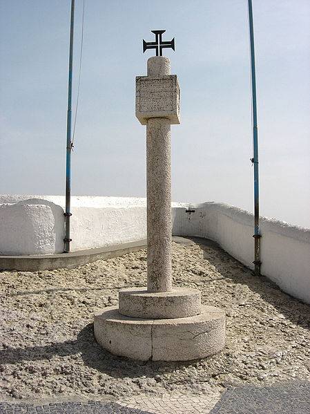
Padran (stone pillar), installed by Vasco da Gama in gratitude to the Virgin Mary for the return of the expedition from India. Nazar, Portugal
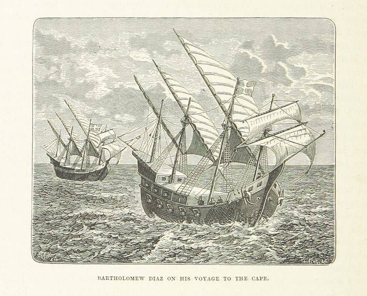
Ship Bartolomeu Dias
In the same year, the king instructed Bartolomeu Dias to go in search of a path to India around Africa. Expedition Dias consisted of three ships, one of which was commanded by his brother Diogo Dias. Under the command of Dias were excellent sailors who sailed earlier under the command of Caen. Dias sailed from Portugal in August 1487, and no details remained on the first part of this expedition. It is known that Dias went to the mouth of the Congo River and then walked along unfamiliar banks. In one of the harbors Dias left a freighter - the smaller of his caravels - guarded by nine sailors. In January, 1488, the storm began, which forced Dias to go out into the open sea. A few days later he tried to return to the bay, but the land was not visible. The struggle with the sea lasted a month. The farther the ships moved south, the more the temperature dropped. Ships carried far into the ocean. Sailors considered themselves dead.
The wanderings continued until February 3 1488, when, turning north, the Portuguese saw the coast of Africa east of the Cape of Good Hope. Landing on the shore, Dias discovered a Hottentot settlement. Negroes accompanying the squadron could not find a common language with the natives, a conflict occurred with them. The Portuguese urgently had to push off. Diash wanted to sail further east, but upon reaching the bay of Algoa (near the modern city of Port Elizabeth), all the officers who were under his command spoke in favor of returning home. The sailors, exhausted by a long expedition and hunger, also wanted to return home, otherwise threatening to revolt. The only concession to which they agreed was three more days to the northeast. In such a short time, Dias ships did not have time to go around the whole southern tip of Africa and reached the mouth of the river, which was named after the captain of the second caravel, Rio di Infanti. Once near the Indian Ocean, Dias was severely disappointed and was forced to turn back.
As a result, the mouth of the Great Fish, where the padran established by him was discovered in 1938, was the limit for the advancement of Dias' expedition to the east. On the way back, the Portuguese went to the cape, to which they had walked for so long. He was called the Cape of Storms (Stormy) in memory of the dangers and difficulties they experienced during the storm, when they first skirted it. Subsequently, the king, who placed great hopes on the sea route to Asia opened by Dias, renamed it the Cape of Good Hope. In August, Dias arrived at Angradush-Voltash harbor. The freighter during this time fell into disrepair, and of the nine sailors left, six died, and the seventh died of sudden shock when he saw his countrymen. The return was calm. The ships made a short stop at the fort of São Jorge da Mina ("The Mine of St. George"). There, Diash took on board the gold received by the governor of the colony from the natives. In December 1488, the expedition returned to Portugal. Flotilla Dias was in the campaign 16 months and 17 days. It was the longest of all the voyages undertaken before the Portuguese.
Strange as it may seem, not only did Diash not receive any reward for his amazing journey, which led to such a great success, but for an unknown reason, he even fell into disgrace. He was no longer assigned to lead any expedition. Only after the death of João II, through 9 years after the return of Dias, did the Portuguese finally send an expedition to India. At the head of it was put Vasco da Gama. Dias was entrusted with the management of the construction of the ships, since he knew from personal experience what kind of design vessels needed to sail in the waters of South Africa. According to his orders, slanting sails were replaced by rectangular, and the hulls of the ships were built with the calculation of small draft and greater stability. Also, in all likelihood, it was Diash who gave Vasco da Game advice as he sailed south, after Sierra Leone, moving away from the coast and making a detour across the Atlantic, because he knew that this was the way to bypass the band of adverse winds. Dias accompanied him to the Gold Coast (Guinea), and then went to the fortress of São Jorge da Mina, whose commandant was appointed. When Vasco da Gama returned and confirmed the correctness of the Dias guesses, a more powerful fleet headed by Pedro Cabral was sent to India. In this journey, Dias commanded one of the ships. He participated in the discovery of Brazil, but during the transition towards Africa a terrible storm broke out and his ship disappeared. The brave navigator died in the waters of the Atlantic in the spring of 1500 year.
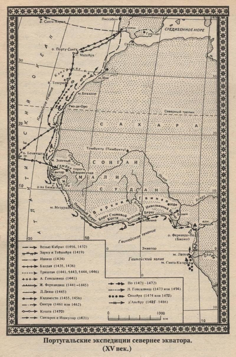
Portuguese expeditions north of the equator

Portuguese expeditions south of the equator (15 century)
The first section of the world
At this time, Portugal has a strong contender. As a result of the marriage of Ferdinand of Aragon and Isabella of Castile, the largest Pyrenean states were united and a united Spain was created. In Europe, a powerful state. With the help of the urban bourgeoisie, the royal couple curbed the violent nobility and large feudal lords. By creating in 1480 - 1485. the Inquisition, the kings turned the church into a powerful tool of absolutism. Spain defeated Granada, the last stronghold of Muslims on the peninsula. As a result, the war ended, which lasted several centuries. Many nobles, knights were left without work. To beat and rob on the peninsula there was no one else. Now they sat idle and became even more dangerous for the monarchy and the cities. In recent years, the Reconquest of the kings in alliance with the townspeople had to wage a stubborn struggle against predatory noble gangs.
Thus, the royal power, the urban bourgeoisie, the nobility and the church were interested in expansion. The royal authorities had to find a way out for the accumulated energy of the Spanish hidalgo in order to prevent an internal explosion. The royal treasury, especially the Castilian, was constantly empty, and overseas expeditions to Asia promised fabulous incomes. The nobles dreamed of land ownership overseas, but even more - about the gold, silver, and jewels of "China" and "India", since most of the nobles were indebted to usurers. The church wanted to turn the Gentiles into the "true faith" by strengthening the power of the king and the Roman throne. The bourgeoisie required initial capital. Everyone needed gold, various colonial goods. Quite rightly described the conquistadors contemporary of Columbus, the author of "The shortest report on the ruin of India" and the multivolume "History of India", Bishop Bartolome Las Casas: "They walked with a cross in hand and an insatiable thirst for gold in the heart."
It was then that the Colombian Genoese suggested Ferdinand and Isabella to find a western Drog in India. From the beginning, Columbus proposed the Portuguese king, João II. After much delay, the Portuguese king handed over his project to 1484 to the academic council, which had just been organized to compile navigational aids. The Council rejected the ideas of Columbus. Apparently, the excessive rights and advantages that Columbus was saying to himself in the event of an enterprise’s success played an important role in the king’s refusal. After much delay and study of the project, Columbus with the help of the monks was able to find the most reliable foothold: he became close to the Spanish financiers (with royal financial advisers, with the Seville merchants and bankers). In 1492, Columbus discovered islands off the coast of America.
The news of Columbus’s discovery of “Western India” alarmed the Portuguese. In their opinion, the rights granted to Portugal by the popes (Nikolai V and Calixtom III) in 1452 - 1456 were violated. These rights, recognized by Castile itself in 1479, confirmed by Pope Sixtus IV in 1481, gave the right to own lands open to the south and east of Cape Bohador, "up to the Indians." Now India seemed to elude them. The Castilian queen and the Portuguese king defended their rights to land overseas. Castilla was based on the right of the first discovery, Portugal - on the papal awards. And the Spaniards objected that the monopoly concerns only Africa. Only the head of the Catholic Church could resolve the dispute peacefully. Pope was then Alexander VI Borgia. He received bribes from both sides and offended no one.
3 May 1493. Papa’s bull Jnter cetera (“By the way”) produced the first section of the world, giving Castile rights to the lands it opened or would open in the future - “lands lying against the western parts on the ocean” and not belonging to any or a Christian sovereign. In other words, Spain in the west received the same rights that Portugal had in the south and east. 4 May 1493 in the new bull (second Jnter cetera) dad tried to pinpoint the rights of Castile more precisely. He granted to the eternal possession of the Castilian kings "all the islands and continents ... open and those that will be open to the west and south of the line drawn ... from the Arctic pole ... to the Antarctic pole ... [This] line must be at a distance of 100 leagues to the west and south of any of the islands, commonly called the Azores and Cape Verde. " It is clear that the boundary set by the second bull cannot be drawn on the map. Already then they firmly knew that the Azores lay far to the west of the Cape Verde Islands. And the expression "to the south of the line drawn ... from ... the pole ... to the pole", that is, to the south of the meridian, is simply ridiculous.
Thus, the pope divided the globe in half according to the “papal meridian” lying in the 100 leagues (about 500 km) of Cape Verde Islands. What lay to the west, the Spaniards received, and to the east - the Portuguese. However, in Lisbon were unhappy. The papal decision formed the basis of the Spanish-Portuguese negotiations, which ended with the Tordesillas Treaty of 7 June 1494. The Portuguese already then doubted that Columbus had reached Asia. Therefore, they did not insist that the Spaniards completely abandoned the transatlantic voyages, but sought only a transfer of the "papal meridian" further to the west.
After much debate, the Spaniards made a concession: the line was drawn in the 370 leagues west of the Cape Verde Islands. The contract does not specify from which island 370 leagues should be counted and in which leagues to calculate. Apparently, we are talking about the sea league (about 6 km). The papal throne did not argue with this decision. Once again, tore off a good sum with the contracting parties and approved the agreement.
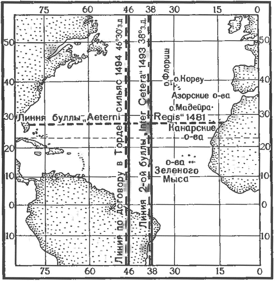
Spanish-Portuguese demarcation lines
To be continued ...
Portuguese expeditions
The Portuguese prince Enrique did not participate in sea expeditions, but by constantly encouraging the navigators and patronizing the explorers of the new lands, he received the name "Sailor", under which he entered history.
Cape Non (Nun) on the west coast of Africa has long been considered the fateful boundary for all navigators. The very name of the cape - “Non”, in Latin means “no” - speaks of how he enjoyed notoriety. In 1419, this cape was rounded off by two Portuguese noblemen, João Gonçalu Sarku and Tristan Teischer, sent by Prince Henrique. A violent storm carried their ship far into the open sea, where they discovered an island called Porto Santo by them. Having surveyed the island, the travelers returned to Portugal. A year later, they returned and noticed another wooded island, which they called Madeira - “Wooded.”
After that, 15 years passed before the Portuguese were able to go around Cape Bochador, guarded, as they said then, by strong sea currents and winds. Only in 1434, captain Gil Eanish, a brave and ambitious man, passed by this cape after the third attempt. The feat of the captain was then compared "with the most glorious exploits of Hercules." Encouraged by this success, Antan Gonçalvesh in 1441 year and Nunyu Tristan in 1444 year progressed further south. The first brought some golden sand from the banks of the Rio de Oro, and the second reached the mouth of the Senegal River, where he captured several Negroes, whom he brought to Lisbon and served at a very high price. That was the beginning of the Negro trade, a trade that literally devastated the Black Continent, which covered the Europeans with shame for four centuries. Tens of millions of blacks were killed and sold into slavery, died from hunger, exhaustion and disease, from inhuman conditions during transportation and slave labor.
Since the 1444 year, the Portuguese have sent entire fleets to Africa for "live goods". People were hunted like wild animals with specially trained dogs. Entire areas were devastated. Part of the tribes entered into an agreement with the Portuguese and engaged in hunting for people of other tribes in the depths of the mainland. Enlightened Enrique Enrique approved human trafficking and demanded a fifth of the income from this shameful and bloody business (but very profitable). The Portuguese chronicler, praising his compatriots, wrote about one successful expedition: “Finally, the Lord God was pleased to give them a victorious day, fame for their work and reward for damages, because on this day men, women and 165 children were captured.
Such a lucrative business undoubtedly accelerated the promotion of the Portuguese even further - to the southern shores of West Africa. In 1445, Dinish Dias rounded Green Cape and explored part of the coast of the Gulf of Guinea. The following year, the Portuguese discovered the Azores. In 1456, the expedition of the Venetian Alvise de Kadamosto, who was also in the service of Henry the Navigator, opened the eastern group of Cape Verde. Every fear of the unknown disappeared. The fatal frontier, behind which, as it was believed before, “the air burns like fire” was left behind. The expedition followed the expedition, each giving new information. The African coast seemed endless. And the further the travelers traveled to the south, the further the desired cape moved away - the extreme southern point of the continent, which it was necessary to go around in order to reach coveted India.
Promotion of the Portuguese along the west coast of Africa continued after the death of Henry the Navigator. The Portuguese king João II added the title of ruler of Guinea to his title. Diogo Kahn in 1484 - 1486's. He explored the western coast of Africa from the equator to the Tropic of Capricorn, nearly beat Bartolomeu Dias in the discovery of the southern tip of the continent. Kahn reached Cape Cross, on which, according to custom, the captain of the ship erected "padran" - a stone pillar with the Portuguese coat of arms. In 1487, João II sent overland two officers, Peru da Covilhã and Afonso di Paiva, to search for Prester John (the legendary Christian state) and the "land of spices". Covilian was able to reach India, but on the way back, having learned that his companion died in Ethiopia, he went there and was detained there by order of the emperor. However, Covilha was able to convey to Portugal a report on his journey, in which he confirmed that it is realistic to reach India by sea, having rounded Africa.
Padran (stone pillar), installed by Vasco da Gama in gratitude to the Virgin Mary for the return of the expedition from India. Nazar, Portugal
Ship Bartolomeu Dias
In the same year, the king instructed Bartolomeu Dias to go in search of a path to India around Africa. Expedition Dias consisted of three ships, one of which was commanded by his brother Diogo Dias. Under the command of Dias were excellent sailors who sailed earlier under the command of Caen. Dias sailed from Portugal in August 1487, and no details remained on the first part of this expedition. It is known that Dias went to the mouth of the Congo River and then walked along unfamiliar banks. In one of the harbors Dias left a freighter - the smaller of his caravels - guarded by nine sailors. In January, 1488, the storm began, which forced Dias to go out into the open sea. A few days later he tried to return to the bay, but the land was not visible. The struggle with the sea lasted a month. The farther the ships moved south, the more the temperature dropped. Ships carried far into the ocean. Sailors considered themselves dead.
The wanderings continued until February 3 1488, when, turning north, the Portuguese saw the coast of Africa east of the Cape of Good Hope. Landing on the shore, Dias discovered a Hottentot settlement. Negroes accompanying the squadron could not find a common language with the natives, a conflict occurred with them. The Portuguese urgently had to push off. Diash wanted to sail further east, but upon reaching the bay of Algoa (near the modern city of Port Elizabeth), all the officers who were under his command spoke in favor of returning home. The sailors, exhausted by a long expedition and hunger, also wanted to return home, otherwise threatening to revolt. The only concession to which they agreed was three more days to the northeast. In such a short time, Dias ships did not have time to go around the whole southern tip of Africa and reached the mouth of the river, which was named after the captain of the second caravel, Rio di Infanti. Once near the Indian Ocean, Dias was severely disappointed and was forced to turn back.
As a result, the mouth of the Great Fish, where the padran established by him was discovered in 1938, was the limit for the advancement of Dias' expedition to the east. On the way back, the Portuguese went to the cape, to which they had walked for so long. He was called the Cape of Storms (Stormy) in memory of the dangers and difficulties they experienced during the storm, when they first skirted it. Subsequently, the king, who placed great hopes on the sea route to Asia opened by Dias, renamed it the Cape of Good Hope. In August, Dias arrived at Angradush-Voltash harbor. The freighter during this time fell into disrepair, and of the nine sailors left, six died, and the seventh died of sudden shock when he saw his countrymen. The return was calm. The ships made a short stop at the fort of São Jorge da Mina ("The Mine of St. George"). There, Diash took on board the gold received by the governor of the colony from the natives. In December 1488, the expedition returned to Portugal. Flotilla Dias was in the campaign 16 months and 17 days. It was the longest of all the voyages undertaken before the Portuguese.
Strange as it may seem, not only did Diash not receive any reward for his amazing journey, which led to such a great success, but for an unknown reason, he even fell into disgrace. He was no longer assigned to lead any expedition. Only after the death of João II, through 9 years after the return of Dias, did the Portuguese finally send an expedition to India. At the head of it was put Vasco da Gama. Dias was entrusted with the management of the construction of the ships, since he knew from personal experience what kind of design vessels needed to sail in the waters of South Africa. According to his orders, slanting sails were replaced by rectangular, and the hulls of the ships were built with the calculation of small draft and greater stability. Also, in all likelihood, it was Diash who gave Vasco da Game advice as he sailed south, after Sierra Leone, moving away from the coast and making a detour across the Atlantic, because he knew that this was the way to bypass the band of adverse winds. Dias accompanied him to the Gold Coast (Guinea), and then went to the fortress of São Jorge da Mina, whose commandant was appointed. When Vasco da Gama returned and confirmed the correctness of the Dias guesses, a more powerful fleet headed by Pedro Cabral was sent to India. In this journey, Dias commanded one of the ships. He participated in the discovery of Brazil, but during the transition towards Africa a terrible storm broke out and his ship disappeared. The brave navigator died in the waters of the Atlantic in the spring of 1500 year.

Portuguese expeditions north of the equator
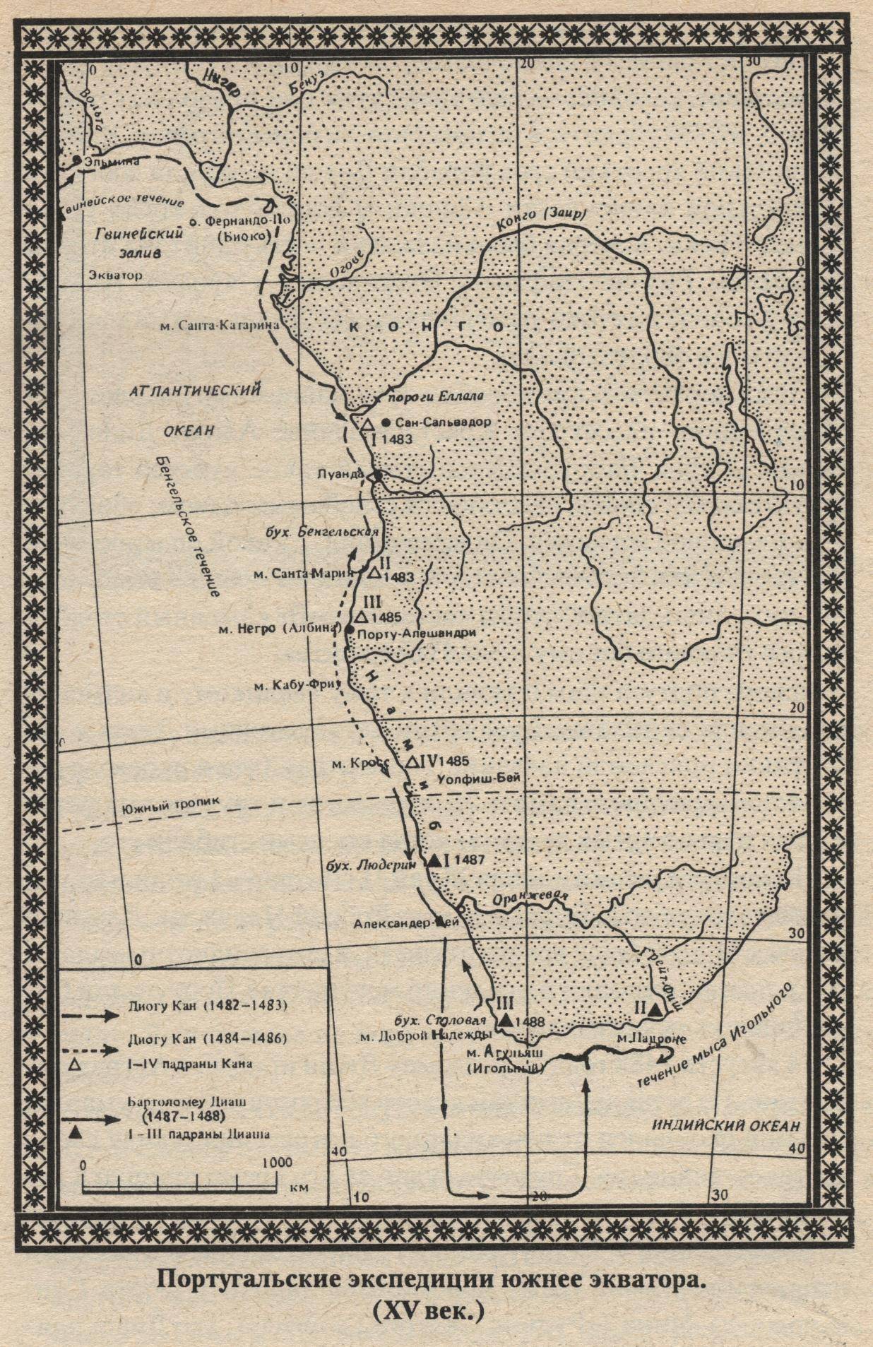
Portuguese expeditions south of the equator (15 century)
The first section of the world
At this time, Portugal has a strong contender. As a result of the marriage of Ferdinand of Aragon and Isabella of Castile, the largest Pyrenean states were united and a united Spain was created. In Europe, a powerful state. With the help of the urban bourgeoisie, the royal couple curbed the violent nobility and large feudal lords. By creating in 1480 - 1485. the Inquisition, the kings turned the church into a powerful tool of absolutism. Spain defeated Granada, the last stronghold of Muslims on the peninsula. As a result, the war ended, which lasted several centuries. Many nobles, knights were left without work. To beat and rob on the peninsula there was no one else. Now they sat idle and became even more dangerous for the monarchy and the cities. In recent years, the Reconquest of the kings in alliance with the townspeople had to wage a stubborn struggle against predatory noble gangs.
Thus, the royal power, the urban bourgeoisie, the nobility and the church were interested in expansion. The royal authorities had to find a way out for the accumulated energy of the Spanish hidalgo in order to prevent an internal explosion. The royal treasury, especially the Castilian, was constantly empty, and overseas expeditions to Asia promised fabulous incomes. The nobles dreamed of land ownership overseas, but even more - about the gold, silver, and jewels of "China" and "India", since most of the nobles were indebted to usurers. The church wanted to turn the Gentiles into the "true faith" by strengthening the power of the king and the Roman throne. The bourgeoisie required initial capital. Everyone needed gold, various colonial goods. Quite rightly described the conquistadors contemporary of Columbus, the author of "The shortest report on the ruin of India" and the multivolume "History of India", Bishop Bartolome Las Casas: "They walked with a cross in hand and an insatiable thirst for gold in the heart."
It was then that the Colombian Genoese suggested Ferdinand and Isabella to find a western Drog in India. From the beginning, Columbus proposed the Portuguese king, João II. After much delay, the Portuguese king handed over his project to 1484 to the academic council, which had just been organized to compile navigational aids. The Council rejected the ideas of Columbus. Apparently, the excessive rights and advantages that Columbus was saying to himself in the event of an enterprise’s success played an important role in the king’s refusal. After much delay and study of the project, Columbus with the help of the monks was able to find the most reliable foothold: he became close to the Spanish financiers (with royal financial advisers, with the Seville merchants and bankers). In 1492, Columbus discovered islands off the coast of America.
The news of Columbus’s discovery of “Western India” alarmed the Portuguese. In their opinion, the rights granted to Portugal by the popes (Nikolai V and Calixtom III) in 1452 - 1456 were violated. These rights, recognized by Castile itself in 1479, confirmed by Pope Sixtus IV in 1481, gave the right to own lands open to the south and east of Cape Bohador, "up to the Indians." Now India seemed to elude them. The Castilian queen and the Portuguese king defended their rights to land overseas. Castilla was based on the right of the first discovery, Portugal - on the papal awards. And the Spaniards objected that the monopoly concerns only Africa. Only the head of the Catholic Church could resolve the dispute peacefully. Pope was then Alexander VI Borgia. He received bribes from both sides and offended no one.
3 May 1493. Papa’s bull Jnter cetera (“By the way”) produced the first section of the world, giving Castile rights to the lands it opened or would open in the future - “lands lying against the western parts on the ocean” and not belonging to any or a Christian sovereign. In other words, Spain in the west received the same rights that Portugal had in the south and east. 4 May 1493 in the new bull (second Jnter cetera) dad tried to pinpoint the rights of Castile more precisely. He granted to the eternal possession of the Castilian kings "all the islands and continents ... open and those that will be open to the west and south of the line drawn ... from the Arctic pole ... to the Antarctic pole ... [This] line must be at a distance of 100 leagues to the west and south of any of the islands, commonly called the Azores and Cape Verde. " It is clear that the boundary set by the second bull cannot be drawn on the map. Already then they firmly knew that the Azores lay far to the west of the Cape Verde Islands. And the expression "to the south of the line drawn ... from ... the pole ... to the pole", that is, to the south of the meridian, is simply ridiculous.
Thus, the pope divided the globe in half according to the “papal meridian” lying in the 100 leagues (about 500 km) of Cape Verde Islands. What lay to the west, the Spaniards received, and to the east - the Portuguese. However, in Lisbon were unhappy. The papal decision formed the basis of the Spanish-Portuguese negotiations, which ended with the Tordesillas Treaty of 7 June 1494. The Portuguese already then doubted that Columbus had reached Asia. Therefore, they did not insist that the Spaniards completely abandoned the transatlantic voyages, but sought only a transfer of the "papal meridian" further to the west.
After much debate, the Spaniards made a concession: the line was drawn in the 370 leagues west of the Cape Verde Islands. The contract does not specify from which island 370 leagues should be counted and in which leagues to calculate. Apparently, we are talking about the sea league (about 6 km). The papal throne did not argue with this decision. Once again, tore off a good sum with the contracting parties and approved the agreement.
Spanish-Portuguese demarcation lines
To be continued ...
- Alexander Samsonov
- How did Western expansion begin?
How did Western expansion begin?
Why created the myth of the "Mongol" invasion
How do Portuguese "predators" create their empire
Information