For the first time, the Navy handed over electronic navigation charts to a ship at sea

66
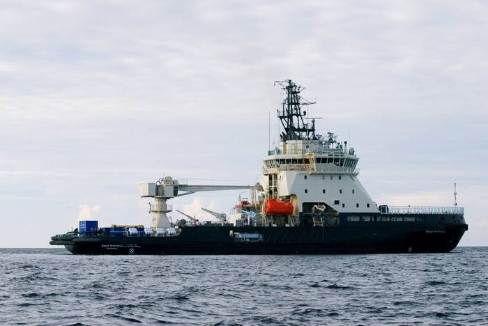
For the first time, the main center of the automated system for providing electronic map information to the Navy handed 280 electronic navigation maps aboard the Ilya Muromets icebreaker at sea, said Igor Dygalo, a representative of the Information and Mass Communications Department of the Russian Defense Ministry on the Navy.

For the first time in stories The Russian Navy has successfully transmitted electronic navigation charts to the ship at sea. The transfer of a set of electronic versions of 280 navigation maps was carried out by the Main Center of the Automated System for Providing the Cartographic Information of the Navy in St. Petersburg on board the newest icebreaker Ilya Muromets being tested in the Baltic Sea
- said Dygalo.


For the first time, the Navy handed over electronic navigation charts to a ship at sea


According to the head of the Directorate of Navigation and Oceanography of the Russian Defense Ministry, captain 1 of the rank of Sergei Travin, special new equipment installed on board the icebreaker Ilya Muromets was used for transmission.

We are talking about the ship complex automation equipment, which, by request of the Navy, is equipped with an icebreaker. The transfer of electronic cards made through a special radio channel from St. Petersburg
- said Travin, quoted by the press service.

He also noted that new automation tools would “successfully provide geospatial information in the form of electronic navigation charts for warships of the Russian Navy in the course of a long-term mission in the far ocean zone”.

Previously, navigation maps of ships and ships of the Navy were supplied at points of deployment during basic and preparatory training, reports RIA News
66 comments
Information
Dear reader, to leave comments on the publication, you must sign in.
  1. +1
    8 November 2017 19: 25
    Type of matrix ??? What is the amount of information coming in? And most likely in a classified form.
    1. +8
      8 November 2017 19: 32
      Quote: LAWNER
      This is how much information comes in?

      Here, the volume is not important (in the end, using a mobile modem it’s easy to download any movie). It is fundamentally important at what distance this volume was transferred.
      1. +11
        8 November 2017 19: 48
        Hi hi hi fundamentally important - that without Western technology, and not through their channels good
        1. +5
          8 November 2017 21: 06
          Good evening, Vladimir! hi
          I hope you are right about the technology. smile
          1. +4
            8 November 2017 21: 14
            Quote: Monos
            I hope you are right about the technology.

            I hope so, but I probably didn’t write about good
      2. +7
        8 November 2017 20: 17
        Quote: Monos
        Volume is not important here.

        Only navigators know what a card depot is!
        What does it mean pre-laying, route selection, plotted reference points, and other professional lotions ...
        Interestingly, the CEP will present to the Flagship (Comdiv, for example) if he only has electronic cards? And if, don’t bring the Almighty, the enemy will conduct an EMP strike on the NK ... Then why are you going to stomp? globally, reckoning ...
        All this is very good, but there should always be a backup mapping method! At the same time, and sextant, oh how, it can come in handy!
        IMHO.
        1. +7
          8 November 2017 20: 30
          I think that equipping an icebreaker with a printer and printing the necessary cards is not a problem today.
          1. +3
            8 November 2017 22: 28
            Well, rather a plotter smile
            1. +2
              9 November 2017 10: 59
              You confuse something, plotters have long since left mass use, .. well, maybe they still use cutting ones.
              Probably, by the word "plotter" you meant a large-format inkjet printer, but then why deliberately substitute concepts?
              1. +3
                9 November 2017 12: 11
                Probably, by the word "plotter" you meant a large-format inkjet printer, but then why deliberately substitute concepts?

                You probably never bought or serviced a "wide format inkjet printer" they are still called plotters bully Type in Yandex "buy a plotter" and make sure
                1. +3
                  9 November 2017 13: 03
                  Yes, anything can be written on the fence, and indexed by Yandex. The question is not this, but the substitution of concepts.
                  Maybe you can find me at least one document (naturally in englishso that there are no translation errors) from, for example, the very popular HP DesignJet series of products (or similar ones), where would it be written inside that InkJet Printer is actually a plotter? (yes, at least just the word plotter was mentioned).

                  PS I’m very aware that in the strange countries of the former USSR large-format inkjet printers are often called plotters, because These printers primarily perform tasks previously performed by real (XY-coordinate) plotters. However, from this, InkJet Printer's do not become these same plotters.
                  1. +2
                    9 November 2017 14: 50
                    where would it be written inside that InkJet Printer is actually a plotter? (yes, at least just the word plotter was mentioned).

                    And you belong to the sect of pedants. Perhaps they have devoted their whole lives to the struggle to eradicate the word xerox in favor of the word copier? bully
                    I am not opposed to accuracy in definitions, only for some reason wrestlers like you really usually hide behind this struggle the scarcity of their knowledge.
                    Here catch the link
                    http://plottertrade.com/?page_id=55
                    and not even a inkjet but a laser
                    1. +2
                      9 November 2017 17: 07
                      An interesting but strange link:
                      1. You gave a link to sellers, who all the same as what is called - if only sold.
                      2. This link offers 2 families of devices (with the commercial names IDEA and XSTREAM), which the Italians (Algotex) call a plotter (for historical reasons - see the history of Algotex company).
                      3. the products (IDEA and XSTREAM) of the Italian company Algotex use the HP45 and XAAR printheads, which are InkJet Printing Heads (i.e. inkjet).
                      4. HP, products with its InkJet Printing Heads (used by Algotex), otherwise it does not name printer.
                      5. XAAR, as I understand it, produces only components for printers, but does not release printers / plotters themselves.
                      6. On the XAAR website (www.xaar.com) the word plotter does not occur at all ... - people make nodes for printers.
                      7. On the HP website (www.hp.com) the word plotter was found only in the museum section, .. with, in fact, XY-coordinate plotters.

                      Well, somehow it turns out.

                      However, in any case, thanks for the link, I was interested to get acquainted with a non-American company and its own terminology (commercial names of products).

                      PS
                      [quote = bk316] [quote] and not even a inkjet but a laser [/ quote]
                      could not be found on the provided link.
          2. +3
            9 November 2017 04: 33
            Have you seen the map at least once to print on the printer? Set the puzzle to assemble.
            1. +2
              9 November 2017 10: 37
              I saw all sorts of cards. Did I write somewhere that in A4 format I need to print? Apparently for you the existence of industrial printers with a roll width, for example 1500mm, is a big secret.
            2. +3
              9 November 2017 12: 13
              Set the puzzle to assemble

              Well, okay, bch-3 is permissible, it’s good that it’s not bch-1
        2. +1
          8 November 2017 22: 42
          It’s convenient for them to chop nuts.
        3. +4
          9 November 2017 04: 31
          Quote: Boa constrictor KAA
          And if, don’t bring the Almighty, the enemy will conduct an EMP strike on the NK ... Then why are you going to stomp? globally, reckoning ...

          I completely agree, my teacher on HF in the second year, seeing our joy at the fact that we were allowed to use GPS during cloudy weather, said: "What will you do during the database when the satellites knock down?"
          1. -1
            9 November 2017 12: 30
            Cards as such most likely are not transmitted at all, they are already available in advance in electronic form. Only the necessary information is transmitted - the location of objects, for example. Its size is small.
            Exactly the same thing applies to GPS - if the signal disappears, there will be no update of the position of objects on the map. However, what was downloaded earlier will not go anywhere. And nothing will prevent you from using such a map with "traditional means" of navigation.
      3. +7
        8 November 2017 20: 49
        Quote: LAWNER
        This is how much information comes in?

        on modern concepts a trifle wink
        PAK CO CIM produces electronic topographic maps of any region of the globe according to aerial and satellite imagery ..
        Digital orthophotomaps of any scale and digital matrices of the terrain, images of objects, their quantitative and qualitative characteristics (recognition and generation using automated stereoscopic interpretation), geospatial data in text and tabular form are transmitted


        Quote: Monos
        It is fundamentally important at what distance this volume was transferred.

        Transas, an automated system for providing the Navy with digital cartographic information (ASO TsKI)
        more precisely KSAP ASO TsKI Navy.
        If far away by satellite (s) = distance does not matter.
        So they all get an Internet connection through any line that satisfies bandwidth and security.

        via hardware-software complex (APC) "server KSAP"


        Quote: pjastolov
        that without Western technology, and not through their channels

        yep ON, yes, iron, not yet, not all
        built on common domestic technologies, technically interconnected and can exchange geospatial and digital cartographic information in a single geo-information space
        :
        • Computing server, Flagman-Z
        • Operating system MS VS 3.0,/FLIR 8.0001-12
        • Database management system Linter VS 6.0,/FLIR 8000.2-04
        • Hardware-software complex "Shield-EDS",
        • KPO "E-mail system product 83t714",
        • KPO "Web Application Server",
        • KPO Doctor Web for Servers.

        The assigned work resource before the repair period in specialized workshops - 60 000 hours;
        The total assigned system resource before decommissioning is 100 000 hours.
        The warranty period of the product is 3 from the date of delivery at the customer’s site, within the warranty period of storage.
        1. +5
          8 November 2017 21: 03
          Quote: opus
          If far away by satellite (s) = distance does not matter.

          hi , Yes of course. Another issue is the reliability of communications in high latitudes. There with satellite coverage is problematic. Or am I wrong?
          1. +4
            8 November 2017 21: 45
            Quote: Monos
            Or am I wrong?

            The service area of ​​CP "Yamal-201"

            Service areas of regional stations of the Gonets system


            How much more then?

            in the organization of satellite communications in high latitudes, modern directions of development of satellite communications systems can be implemented, such as the use of network technologies, integration with terrestrial communication networks and data transmission, unification and standardization of communication technologies and data transmission and other..

            It is possible so
            Server KSAPb -> Server KSAPk (intermediaries) -> Server KSAPk (final)
            1. +7
              8 November 2017 23: 07
              Anton, info in two comments is open or ......? And then, something palms begin to sweat from the eye of the "elder brother." bully Joke.
              1. +2
                9 November 2017 00: 03
                Quote: Okolotochny
                Anton, infa in two comments open or

                open what

                Complex user automation

                "KSAP"

                specifications

                APPROVAL SHEET

                SKBV.42 5180.103-02 TU-LU

                tender was

                DOCUMENTATION ABOUT OPEN
                AUCTION
                ELECTRONIC FORM
                for the supply of a set of consumer automation equipment
                automated digital processing system
                Navy Map Information (KSAP ASO TsKI Navy)
                for the needs of the Ministry of Defense of the Russian Federation
  2. 0
    8 November 2017 19: 25
    the beginnings of a large electronic brain
  3. +3
    8 November 2017 19: 27
    Finally drowned. One misunderstanding. Did the captain have a card? Our people are used to walking on their cards. I don’t understand this. "in the form of electronic navigational charts, warships of the Russian Navy entering a long-term mission in the far ocean zone." Is there something that has risen or has the current changed?
    1. +11
      8 November 2017 19: 33
      Great buddy!
      Tests are underway, the system is new! They look, test, how over long distances ...
      1. The comment was deleted.
      2. +5
        8 November 2017 19: 56
        So I hope that it’s a good idea. Although, at the present time, everything is sensible with us! Healthy, friendly! How much time! For relax. Or that.
        1. 0
          8 November 2017 20: 15
          rotting western did not sing our marches
          "Well, to the side of the neck and the Beatles, we’ll play the march, the old, forgotten ..."
        2. +10
          8 November 2017 20: 20
          Long time no see, for sure! Thanks for the music!
          That's about the cards: It would be interesting to know what degree of protection of this system ... And what will happen if there are no satellites? And they will not, in the case of a large kipish ...
          1. +4
            8 November 2017 20: 26
            Ну Logall! Ours are able to work with maps, unlike potential ones. Today, with our boy, we calculated the location points of Amer aircraft carriers on a map. The guy calculated up to a second. Latitude, longitude, time, minutes, seconds. Eleme
            amber! There are simple protection cards. Electronic ones, who knows. I’m from my belfry. Maybe the sailors will explain. I’m from Aviation. Not sea. And what will happen if there are no satellites? Then we will win. None of the potential cards are already fumbling. And with us, this is the basis for preparing navigators. Everyone on our ships knows how to read maps. How do I know? Uncle moreman. Almost 40 years in the Navy.
            1. +1
              8 November 2017 20: 42
              Satellites are not stan; stars will not go anywhere. You can always determine your place.
              1. +4
                8 November 2017 21: 46
                Thank you heather! Blues are just a bomb. I’ll definitely find backing tracks on the Internet and try to play solo, train my neighbors.
                1. +2
                  8 November 2017 22: 05
                  Quote: Neputin
                  Thank you heather! Blues are just a bomb. I will definitely find in
                  Minus the Internet and try to play solo, train my neighbors.


                  That's right!
                  Thanks Heather. Listened to blues decided to finish work and listen to music
                  To start, Deep Purple
                  1. +2
                    9 November 2017 16: 04
                    To start, Deep Purple Well, these guys are hefty serious. I sometimes, in a quiet voice (don’t tell anyone), I listen to Jeepsie Kings ... wassat
                    1. +1
                      9 November 2017 17: 23
                      Quote: VERESK
                      To start, Deep Purple Well, these guys are hefty serious. I sometimes, in a quiet voice (don’t tell anyone), I listen to Jeepsie Kings ... wassat


                      I agree, but I don’t listen to everything from them, not in those years
                      but this

                      and more
                      1. +3
                        9 November 2017 17: 28
                        Gorgeous. Catch mine.
                2. +2
                  9 November 2017 16: 07
                  Neputin My reckoning! If you are a lover of blues-sniffing! On the site guys and girls love the Blues. Not about the moderators it is said. Alas. They can ban ...
            2. 0
              8 November 2017 22: 14
              Quote: VERESK
              Ну Logall! Ours are able to work with maps, unlike potential ones. Today, with our boy, we calculated the location points of Amer aircraft carriers on a map. The guy calculated up to a second. Latitude, longitude, time, minutes, seconds. Eleme
              amber! There are simple protection cards. Electronic ones, who knows. I’m from my belfry. Maybe the sailors will explain. I’m from Aviation. Not sea. And what will happen if there are no satellites? Then we will win. None of the potential cards are already fumbling. And with us, this is the basis for preparing navigators. Everyone on our ships knows how to read maps. How do I know? Uncle moreman. Almost 40 years in the Navy.

              Grandma is a sniper?
  4. 0
    8 November 2017 19: 49
    And so it was possible? I understand that this is a set of files that contain some kind of "tablecloths", which are "pulled" onto an electronic tablet. It’s also long been possible to drive the “digit” on the air (even Popov and Morse were weird). Compare received with sent .... I do not catch the novelty ....
    1. +1
      8 November 2017 20: 13
      Well, there probably information is encoded. And all the navigation equipment of the ship is docked with the information received.
      1. 0
        8 November 2017 20: 27
        Well, there surely the information is encoded
        It is already encoded, but this does not cease to be a file that is transmitted in packets. Roughly: the station sends a packet, the ship receives and sends back. The station compares the sent and received packets. If everything is fine, then sends the next one.
        When the "flash drive" of the ship is full, there is "equipment and dock."
        And where is the novelty?
        1. 0
          8 November 2017 20: 44
          And where is the novelty?

          reception and transmission of information in a classified mode of guaranteed durability, a large volume over a long distance, plus not only a map, but also the situation data with coordinates on-line.
        2. +1
          8 November 2017 23: 08
          That’s just the point that it seems “everything is simple”, but most likely - the technology was developed to provide warships with up-to-date operational information. That everyone (to whom it is supposed) should not “shine on the whole district” with a radar and beacon this as a “target”, but have full information (from headquarters) “who, where, for what”! good Of course, these were not just maps as they were shown at school, but most likely the ice conditions, the location of surface and underwater craft, currents, the movement of hurricanes, etc. And so it’s an ash stump that they already have “paper” cards and other positioning devices.
  5. 0
    8 November 2017 19: 52
    Only good, but ... control (sorry). It is clear that different departments - but, as usual, this is not possible, but he is not in the know - but in general both sides lose. Look for a compromise, sort of like to the office - presenting (I do not laugh) - think men.
  6. 0
    8 November 2017 20: 07
    Automated center for providing electronic cartographic information, everything else is husk)
  7. 0
    8 November 2017 20: 10
    The underwater terrain and currents change more often than the mood of the wife, so maps need to be changed regularly. But you need a Hydrographic Fleet, on a scale no less than Soyuzny. Can this be the whole point ???? Transfer updated maps in real time ???
  8. +2
    8 November 2017 20: 17
    Could download these maps from the Internet wassat
    1. 0
      8 November 2017 22: 22
      Quote: Herkulesich
      Could download these maps from the Internet wassat

      Ask Google?
      I noticed interesting things there. Not a professional, but there is something to think about. For example, Station square of the city. Resolution cards - individual people are visible and shadows from them, in accordance with the time of day. It's kind of like an ad-look, Man, how we look at you. Next, leafing through. Near our regional capital is a closed town. And the image of the place, as if Pablo Picasso waved a mop. Like, I don’t see anything, I don’t smell anything and so on ... Are you going to walk on such cards?
      1. +1
        8 November 2017 23: 12
        And here it’s clearly a “mutual agreement” - we don’t post your closed zones to the whole world, and you don’t show ours "(between the USA and the USSR / Russia). What would any black-asses neither of us have" uncontrolled "on closed objects They generally didn’t roam, the United States has even more problems than ours, because it will have more opponents and those who want to “bang.” And start Russia to put out “high-quality satellite images” of the closed objects of the USA in the openings - on September 11 they will see them as a children's party. bully
  9. 0
    8 November 2017 20: 28
    Transis ECDIS Navi-Sailor 4000 MFD Apparently
  10. +1
    8 November 2017 20: 30
    The cards were transferred, which means you can transmit other voluminous information. Coordinates of goals, for example, operational environment.
    1. +1
      8 November 2017 22: 29
      Quote: Igor V
      The cards were transferred, which means you can transmit other voluminous information. Coordinates of goals, for example, operational environment.

      Why goal coordinates? FLIGHT TASKS. Faster and eliminates unnecessary transmission link, which eliminates the likelihood of loss of secrecy and errors.
  11. 0
    8 November 2017 20: 36
    Let them throw films on my computer
    1. 0
      8 November 2017 22: 31
      Quote: Bronevick
      Let them throw films on my computer

      http://firebit.net/новинки/

      Take it yourself.
  12. 0
    8 November 2017 20: 51
    Quote: Cook
    I think that equipping an icebreaker with a printer and printing the necessary cards is not a problem today.

    What for? You can send a flash drive a dove!
    1. 0
      8 November 2017 21: 37
      I just answered the question of UdavaKaa, what will they show the inspector if that. And about reservation too. So your joke is not quite a topic. By the way, in aviation this method of updating FMS navigation databases has been used for quite some time.
  13. +1
    8 November 2017 21: 25
    I hope that the Shtatovs do not read VO, and then specialists immediately declassify all secrets))))
  14. 0
    8 November 2017 21: 36
    Electronics are good, but paper is still necessary. And then we’ll be striped-striped. Electricity ran out and got lost.
    1. 0
      8 November 2017 22: 36
      Quote: tralmaster.
      Electronics are good, but paper is still necessary. And then we’ll be striped-striped. Electricity ran out and got lost.

      Not everywhere paper is needed. If printed, then ensuring the preservation of state secrets from its loss will be difficult. Easier to look at in a dark room with shielded walls. If there will be no light. what to do to the steamer? For such things, there are many ways to maintain performance.
      1. +1
        8 November 2017 23: 56
        Well, do not tell tales, we know we served. The whole ball had pictures. You will confirm the preliminary gasket also in electronic form.
        1. 0
          9 November 2017 00: 19
          Yeah! Digitally Signed Flag! laughing
        2. +2
          9 November 2017 01: 02
          Quote: tralmaster.
          Well, do not tell tales, we know we served. The whole ball had pictures. You will confirm the preliminary gasket also in electronic form.

          Today, multistellar bosses are also able to sign electronically. Kohl nuclear submarines in such drawings began to shave, and lag behind here is a sin. If on paper, then only with pens. If in a computer it is possible to organize CADs. It’s more convenient to scale on a computer. Either large coverage or detailed. This is not for you to crawl on the floor with a curvimeter.
  15. 0
    9 November 2017 01: 36
    I’m curious about it, but how did they get rid of it before, through VKontakte and Facebook?
  16. kig
    +2
    9 November 2017 02: 22
    Electronic cards have long been used in world shipping. This makes life easier for navigators, since corrections are received continuously and automatically, and most importantly, they increase the safety of navigation, because human errors during proof-reading are minimized. Initially, updates came with mail in each port, on disks, but for quite some time everything has been done via the Internet, through a special modem. However, a set of paper cards is still present.
    Here is a picture of the OOCL Germany container ship bridge built in 2000.

    and here is the ECDIS display integrated in the control panel

    well, a paper card next to it
  17. +1
    9 November 2017 05: 15
    In general, this is called transferring files over satellite Internet, al no?
  18. +2
    9 November 2017 17: 48
    HEATHER,
    Slightly deviated.