It's time to stop the assassination of the Russian Arctic
 On October 16, 1991, Prime Minister Yegor Gaidar arrived at the port of Tiksi and said historical phrase: "The North is artificially populated, and there is no sense in containing it." The great reformer brazenly lied. The Arctic coast and the Northern Sea Route were mastered by the Russian people unbeknownst, and sometimes contrary to the Moscow princes and St. Petersburg emperors.
Another question is that the Russians, who boated to Spitsbergen and Novaya Zemlya, did not leave pompous lines in the chronicles and chronicles. The thing is everyday. So we can judge about their campaigns only from the fragments of the chronicles, which are usually very stingy: “In 1363, the Novgorod ushkuyniki with voivods Alexander Abakumovich and Stepan Lyapa reached the Ob River. Here they were divided, part went down the Ob River and returned to the Arctic Ocean, and the rest went up the river to the junction of the borders of Chagatai Ulus and China. ”
EVERYONE IS KNOWN "UNKNOWN LAND"
In 1594, the Dutch Carnelius Nye and William Barents opened Terra Incognita for Europe. However, at Cape Cain Nose, the Dutch got lost in the ice and mists. But on July 9 they were lucky: Nye met four Russian boats, heading for the mouth of the Pechora. The sailors discouraged him from going to the Yugorsky Ball, because he was “filled with ice, underwater rocks, as well as walruses and huge whales threatening the ships with danger.” The Dutch, however, did not obey, and 16 July went further east with warm, even hot weather, and again met the boat with the Russian fishermen. The Dutch learned that 81 km to the mouth of the Pechora and there is an excellent harbor. Well, the Russian Frost Sea became known as the Barents Sea.
From the Kola Peninsula to Cape Dezhnev, 15 of navigable rivers flow from south to north, along which Cossacks and Russian industrialists walked along the XVI – XIX centuries, exploring the North. They not only descended and climbed the rivers, but also crossed the Arctic Ocean from one river to another: from the Northern Dvina to the Pechora, from the Pechora to the Ob, etc.
In 1632, the Yenisei centurion Pyotr Beketov laid a jail on the Lena River, which started the city of Yakutsk, and after 10 years, Cossack detachments descended to the mouth of the Lena. From here, Cossack Ivan Rebrov walked by sea to the west to the Olenek River, and Ilya Perfiryev - to the east to the Yana River. Soon the kochi explorers began to reach the Anabar River and to the east - to Indigirka. In 1644, the Lower Kolyma burg was laid at the mouth of the Kolyma. And in 1648, the Cossack Semyon Dezhnev climbed the Kolyma River, went out into the ocean, and 20 of September of the same year circled the Big Stone Nose, later called Cape Dezhnev.
The first ship appeared on the Pechora River in 1864, on the Ob - in 1844, on the Yenisei - in 1863, on the Lena - in 1861. In 1913, there were 20 steamers and 20 barges on Pechora, 212 steamers and hundreds of barges on Ob and Irtysh, 26 steamers and 30 barges on Yenisei, 192 steamers and 245 barges on Lena. Most of the ships were built or assembled on the banks of rivers. But several dozen ships in 1860 – 1914 were bought in Europe and transferred to the rivers of Siberia on their own.
In 1878, for the first time in history, the wooden schooner "Vega" by the Swedish navigator Nordensköld passed the Northern Sea Route (NSR) in one (!) Navigation. So, the Swedes are the pioneers of the NSR. And the Norwegian Fridtjof Nansen in 1893 took and named the sea by the name of Nordenskjöld.
They did not argue in Russia; two revolutions, the Japanese, German and Civil wars, took place there. Accordingly, the name of the Siberian multimillionaire Alexander Mikhailovich Sibiryakov, the owner of the factories, gold mines, Yenisei, Lensky and Amur shipping companies, was forgotten. Meanwhile, it was he who decided to organize the “Northern Delivery”, that is, to charter sea vessels and deliver goods from Europe to the mouths of the Yenisei and Lena, from where river steamers of Sibiryakovo companies would transport them to the center of Siberia.
In 1876, Sibiryakov chartered the 400-ton steamer Imer, which was supposed to deliver the cargo to the mouth of the Yenisei River, where the steamer of the Sibiryakov society was waiting for him. Sibiryakov offered the Swede Erik Nordenskiöld to command "Imer". In 1878, an iron screw ship “Lena” of a “river – sea” class was built specially for Sibiryakov in Sweden. Sibiriakov was hired to command the Swede Johansen, and Nordenskiöld was asked to travel. So it was or a little different, but it was the iron “Lena” that passed Chelyuskin Cape first, and after it was a wooden schooner “Vega” together with Nordensheld.
28 August 1878 of the year “Lena” and “Vega” came to Tiksi at the mouth of the Lena River. Then "Lena" went up the river, and "Vega" - to the east. September 27 "Vegu" wiped in the Kolyuchinskaya Bay in 222 km from the Bering Strait. Vega was wintering for 11 months and left only 18 July 1879 of the year. Where the phrase appeared in reference books: “Nordenskiöld passed the NSR during one navigation”, one can only guess. “Lena,” under the command of Johannsen, walked along the Lena for three more years, and later repeatedly went to sea, went to the mouth of the Yana, etc.
Moscow fixed the voluntarism of Mr. Nansen only in 1935: the Nordenskjold Sea became the Laptev Sea — Russian officers who had been in those parts a century and a half before “all sorts of different Swedes.”
IMPROVING THE ROLE OF SEVMORPUTY
The movement of Russian commercial ships on the Arctic Ocean at the beginning of the twentieth century was a routine matter, and only the local press wrote about them. Here are some examples.
21 August 1905 of the year “Siberian Bulletin” No. 172 reported: “In the polar way 12 (25) in July from Hamburg went to the river Yenisei two ships bought by the Ministry of Railways: Krasnoyarsk and Yeniseisk. Steamships are bought to increase the means of transportation on our Siberian rivers. ”
25 September 1905 of the Year “Siberian sheet” No. 75: “Left the Yugorsky Ball to Yeniseisk 1 of August under the command of Lieutenant Colonel Sergeev and Lieutenant Melyamov steamers: Yeniseisk, Turukhansk, Angara, Lena and Krasnoyarsk” indicator 450 – 850 forces, knots 11 – 14 speed, draft 5 – 6 feet; coal burning, in addition, 10 barges, also iron, with a load of coal, draft six to nine 3 ft., with a capacity of 500 – 800 tons, to the mouth of the river. Yenisei sea tug, 3 sea cargo and railway cargo to 12 thousand tons. "
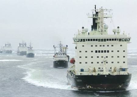
However, before the start of the 1930-ies there was no need for transit flights along the Northern Sea Route, although dozens of ships sailed the NSR annually. And only 17 of December 1932 of the year by the decision of the USSR Council of People's Commissars established a single transport and economic body - the Main Directorate of the Northern Sea Route (Glavsevmorput), which was responsible for the technical equipment of the route, the organization of regular transportation and safety of navigation along this route.
In connection with the development of the Northern Sea Route, it became necessary to include Siberian rivers in the navigation system. Until October 1917, from the Siberian rivers, only Ob, Yenisei and Lena were used for shipping, and even then not all along their length. By 1941, significant portions of Pyasina, Khatanga, Hetty, Anabara, Vilyuy, Aldan, Indigirka, Kolyma and other rivers were included in the river navigation system. In the Far North, during the years of Soviet power, new industries were created for these areas: coal, oil, etc. The fish, forestry and paper industries, as well as the fur and hunting farms, gained tremendous growth. In navigation 1933, the first test cargo flight to the mouth of the Lena was made and a pass-through flight to the Pacific Ocean from west to east was repeated. 8 August 1933 from Arkhangelsk from the Arkhangelsk took three logging trucks on the first Lena voyage.
Since 1935, the Northern Sea Route has become a permanent transportation hub of the country. The solution of the transport problem contributed to the economic growth of the previously backward regions of the North. The emergence of new large industrial centers in Siberia necessitated a further increase in traffic. Already in 1936, the turnover of the Northern Sea Route reached 271 thousand tons.
For the development of the Northern Sea Route, an ice-breaking and transport fleet adapted for navigation in the ice was created. During the years of Soviet power, the ports of Dikson, Ust-Port, Igarka, Dudinka, Tiksi, Ambarchik and others were built and equipped. Airborne ice reconnaissance in the Arctic, launched in 1924 by one aircraft, was carried out by 1940 in 24 in the year. Airfields and landing sites were built. In the 1932 year, there was not a single lighthouse throughout the entire Northern Sea Route, and by the beginning of 1939 navigation, there were already 11 beacons and 315 lights.
In addition to economic importance, the Northern Sea Route also had important military significance - it was the shortest way to transfer warships from the North fleet to the Pacific Ocean. Already in 1936, the Stalin and Voikov destroyers crossed over from Murmansk to Vladivostok in one navigation, and in 1940 the X-series Sh-429 submarine took the same route.
During the Great Patriotic War, hundreds of merchant and military ships passed the Northern Sea Route. In 1941 – 1945 years, 17,5 million tons of cargo was delivered by ship from England and the USA to the USSR. Of these, 47,1% were delivered across the Pacific Ocean, 22,7% - across the Atlantic Ocean and the Barents Sea to Arkhangelsk and Murmansk, and 2,5% (350 KT) - through the Northern Sea Route.
It is important to note that the Soviet propaganda, mentioning the NSR, focused the population’s attention exclusively on through transit flights of ships. No doubt, after 1945, several dozen vessels made end-to-end flights for navigating through the NSR. However, over 90% of them accounted for hauling ships (ships) from the west to the rivers of Siberia and to the Far East. Vessels of all classes walked along the NSR: cruisers of the 68bis and 58 projects, destroyers, large anti-submarine ships, submarines, including missile ships, large hunters, border ships of all classes. On the Ob, Yenisei, Lena, Kolyma, Indigirka and Amur river dry cargo ships, tankers, tugs, passenger ships, suction dredgers, etc. were distilled.
The main share of the transportation of goods through the NSR fell on the export of timber and natural resources from Siberia and the delivery of fuel, food, huge turbines for hydropower plants, etc. to Siberia.
In Soviet times, mineral deposits were top secret. Nobody should have known where gold is mined, how it is mined and who mines it. In secret and modern secret resolutions of the Central Committee of the CPSU and official documents it was spoken about the mining of lead in the south of the Chelyuskin Peninsula and at Pevek, but in fact uranium was encrypted under lead. Therefore, little was written about river shipments, and they didn’t write at all about some rivers like Kolyma. And the man in the street had the impression that the NSR serves exclusively for transportation on the Murmansk-Vladivostok highway.
NEW REALITY
Perestroika broke out. As a result, in the 1990 – 1998, the turnover of cargo along the NSR dropped by 1980 compared to 3,5. Moreover, in the Western sector of the Arctic (the Murmansk – Norilsk highway), transportation decreased by 2,8 times, and in the Eastern sector - by 16 (!) Times. In the 1996 – 2000 years, the number of vessels capable of going to the Arctic has more than tripled and by the beginning of the 2001 year was only 60 units.
Due to the shortage of Arctic tankers in the Russian Federation since 1992, mainly tankers from Latvia, Finland, Germany, etc. took part in navigation on the NSR. A typical example: the Soviet tanker Ventspils, built at the expense of the Union budget, under the Latvian flag and with a captain and a team of ethnic Russians, carried oil products in the Arctic, and the money went to Riga.
A typical scheme for the removal of ships from the sea and river shipping companies of the North: the captain receives an order from the leadership to go to Vladivostok or to the ports of the Black Sea. There, nobody knows anything about their arrival, and after two or three days the “brothers” appear and offer to sell the ship “for cash”. And ten times lower than the market price.
In the middle of the 1990s, our venerable scientists and economists began to promote fantastic projects. Due to the warming in the Arctic, the NSR must become a serious competitor to the Suez Canal! Most ships will go through the Arctic, as this is a shorter route. And there are no pirates in the Arctic. In short, Vasyuki will be renamed to New Moscow.
Alas, the miracle did not happen. Arctic ice does not want to melt. Insurers fight for transit through the NSR is several times more than the way through the Indian Ocean. In August 2015, the second branch of the Suez Canal was opened. This made it possible to increase the daily throughput from 47 to 97 vessels.
In 2014, transit freight traffic through the SMP fell by 77%: to 274 thousand tons against 1,18 million tons in 2013 year. 23 transit flights were carried out, including 6 by foreign flag vessels.
Moscow allowed foreign vessels to sail on the NSR in 1991. Even by approximate calculation, the number of foreign commercial vessels that have passed since that time is approximately equal to the number of research, that is, intelligence vessels of Norway, Sweden, the United States, Italy and other countries. Why do I equate two seemingly different classes of ships? Yes, because foreign scientific research in the Arctic is 90% applied military nature. For political correctness, let's call this “dual purpose research.”
But the talk of New Vasyuki received a great political response.
 TERRITORIAL DISPUTES
It should be said a little about the territorial sections of the Arctic.
In 1921, Canada declared that all lands and islands north of its continental possessions fall under its sovereignty. The CEC and the Council of People's Commissars of the USSR made a similar decision in 1926. Thus arose the sectoral division of the Arctic. It divided only five countries — the USSR, Norway, Denmark, the USA, and Canada — into sectors whose peaks were the North Pole, bases — the northern borders of these states facing the pole, and geographical longitudes served as laterals.
Until 1991, the sectoral division of the Arctic was seriously not contested. But in 1997, Yeltsin Russia signs the convention on the law of the sea 1982 of the year. It provides coastal states with control over the continental sea shelf (the seabed and subsoil of submarine areas outside the territorial waters of the state). At the same time, according to Article 76 of the Convention, no country has the right to establish control over the Arctic, but states having access to the Arctic Ocean can declare their territory to extend to 200 miles from the coast as their exclusive economic zone. This zone can be extended to 150 nautical miles if the country proves that the Arctic shelf is a continuation of its land territory. In its economic zone, the coastal state has a preferential right to mining.
The 1982 convention of the year is at least suited to the Atlantic, Pacific and Indian oceans. There, before the convention, ships freely went outside the territorial waters, and outside the economic zones, fishermen caught fish and installed drilling platforms for mineral exploration and mining. Transportation of goods over the warm ocean is the cheapest.
According to the 1982 Convention of the Year, all the islands in the Arctic sector of Russia belong to Russia, and the central part of the Arctic Ocean, which is constantly covered with ice in winter and partly in summer, is a neutral territory. To get there, with the exception of the edges of the Russian sector, it is possible only by using the Northern Sea Route and entering the territorial waters of Russia. Through the pole in the Russian sector on airplanes or submarines you can deliver polar stations, research or spy equipment. But any economic use of disputed waters in the polar regions of the Russian Arctic is technically impossible.
I will note that the talkers of the projectors from the science of rapid melting of ice in the Arctic over the past 2 – 3 of the year have subsided noticeably. Such a warming in the Arctic, so that transport vessels can walk across the pole, is unscientific fantasy.
It is curious whether those who signed the 1982 Convention of the Year knew that the sectorial borders of the USSR in the Arctic were stable, and now they are floating. Scientists will open a new ridge, and the Russian Federation or Canada announce a huge chunk of the Arctic as their economic zone. In the Russian sector of the Arctic, our scientists have discovered dozens of islands that became the territory of the Russian Federation since 1997, and “closed” several islands that turned out to be centuries-old ice fields.
You say: think, who needs deserted mountainous islands? But the accession of the island-rock gives power 1172 square. km (!) of territorial waters. And an island the size of 10 miles already brings 2250 square. km, etc. At the bottom of this water there may be hydrocarbons and other minerals. And Russia has the right not to let anyone into its territorial waters.
WASHINGTON AIMS ON THE ARCTIC
1 and 2 June 2012, US Secretary of State Hillary Clinton, visited Norway during her visit to Scandinavia. After staying in Oslo, the capital of Norway, she, accompanied by Norwegian Foreign Minister Jonas Store, traveled to the north of this country, to the city of Tromsø. After negotiations at the joint press conference, Store declared the town of Tromsø (with a population of 67 thousand) "the capital of the Arctic", and the United States - the leading state in the Arctic.
The official US government document 2007 of the year, entitled “Joint strategy of the maritime state in the 21st century”, says: “Climate change is gradually contributing to the release of the Arctic zone from beneath the ice, which is important not only for the extraction of new resources, but also for the construction of new marine ways ...
The task of preserving the global mobility of US military and civilian ships and aircraft throughout the Arctic region is important. ”
That is, this is a repetition of the old American doctrine: "Our ships go where they want and our planes fly wherever they want, regardless of the borders of foreign states."
In the 2012 – 2016 years, the US authorities have not yet tried to realize their ambitions in the Arctic. In my opinion, this is due, firstly, to the lack of significant warming in the Arctic, and secondly, to a sharp deterioration in the situation in Ukraine and Syria. Nevertheless, the United States, Norway and a number of other countries officially believe that the Northern Sea Route is an international maritime route. Communications of the Arctic de are "the common heritage of all mankind."
It is clear that neither the US, nor the EU, nor the countries of Asia will receive any economic dividends in the event of the internationalization of the Northern Sea Route. The US goal is to create a military threat to Russia from the North. This is a minimum program. The maximum program - the capture of Siberia, followed by the collapse of all of Russia.
The Pentagon plans to launch dozens of cruisers and destroyers carrying Tomahawk cruise missiles and the Aegis missile defense system onto the Northern Sea Route, which can shoot down Russian ICBMs launched from mine launchers and from atomic submarines on ascending trajectories. I note that most of our ICBMs are programmed to fly across the North Pole. In turn, the Tomahawk cruise missiles have a range of 2200 km and from the Northern Sea Route can hit almost the entire territory of Russia, including Moscow, Volgograd, Chelyabinsk, Novosibirsk, Yakutsk, Komsomolsk-on-Amur, Petropavlovsk-Kamchatsky, etc.
Rejection of Siberia from Russia is an old dream of the United States. After all, the Russian North, where 1% of the population of the Russian Federation lives, gives 20% of Russian exports! By taking control of the Northern Sea Route, the US fleet will be able to manage the Northern Delivery. Formally, you can find fault with anything, with the same ecology. Western merchant ships will move uncontrollably along the coast of Siberia, climb up rivers, smuggle trade, carry out “humanitarian aid”, and establish contacts with the separatists.
The internationalization of the Northern Sea Route for Russia will be a realization of the proverb: "The claw is stuck - the whole bird is gone." And now it turns out that Russia is financing the expeditions of Western intelligence vessels, Greenpeace members and others like them to our Arctic sector. I note that only state subsidies for the maintenance of nuclear-powered icebreakers in 2009 amounted to 1800 million rubles. And how much does the maintenance of diesel-powered icebreakers, research vessels, meteorological stations, etc., cost, without the functioning of which movement along the Northern Sea Route is impossible?
One more example. In 1977, the Inuit Circumpolar Council, that is, the tribes of Northern Canada and Greenland, was created in Canada. Unfortunately, after 1991, this council began to interfere in the internal affairs of the Russian Federation and recruit supporters in Chukotka and Yakutia. It is clear that small groups of separatists do not pose a particular danger to the Russian Federation. But if the American fleet appears on the NSR, the situation will change dramatically.
In my opinion, the Russian Federation should withdraw from the 1982 Convention of the Year in the sections relating to the Arctic, and return to the sectoral division of the Arctic Ocean. I note that Canada, which formally signed the 1982 Convention of the Year, has made a lot of reservations, taking into account that Canada has almost retained its Arctic sector. Well, the United States did not sign this Convention at all. Why should not Russia have a similar freedom of action?
It is also strange that in the 2014 – 2015 years, no one in the Kremlin realized in response to the imposition of sanctions against the Russian Federation to introduce retaliatory sanctions in the Arctic. All non-commercial vessels of countries that have joined the sanctions, including icebreakers, research vessels, private yachts, etc., should be forbidden to cross the Northern Sea Route. Sanctions gave us the perfect reason for imposing such a ban.
Information