GLONASS / GPS navigator "Grot-M"
Last summer, in my blog, I raised the topic of comparing Russian and American navigators used by the military departments of the two countries. After some time, the developers of the Russian navigator came to me and offered to show their offspring and tell more about it.
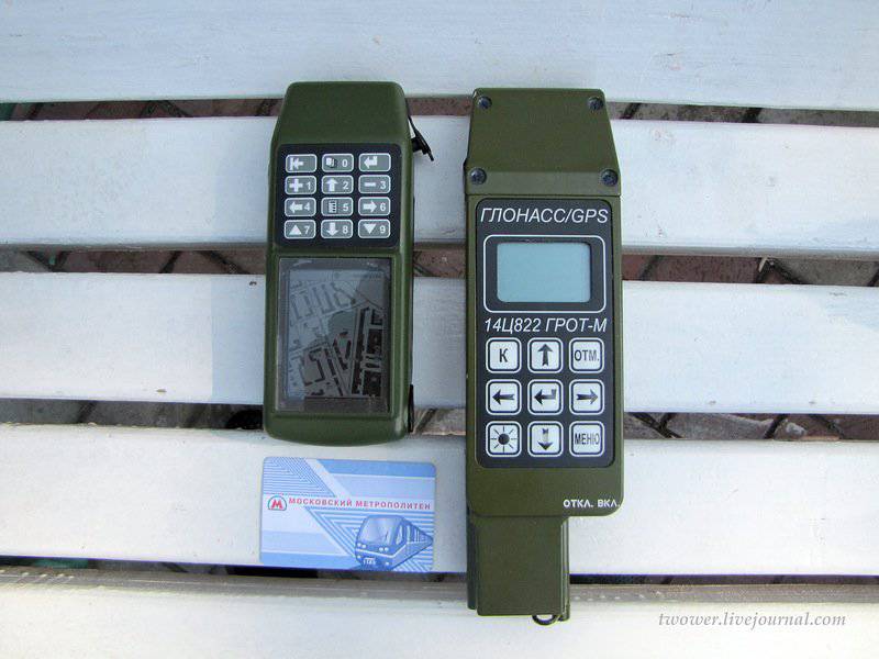
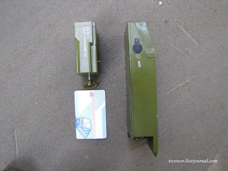
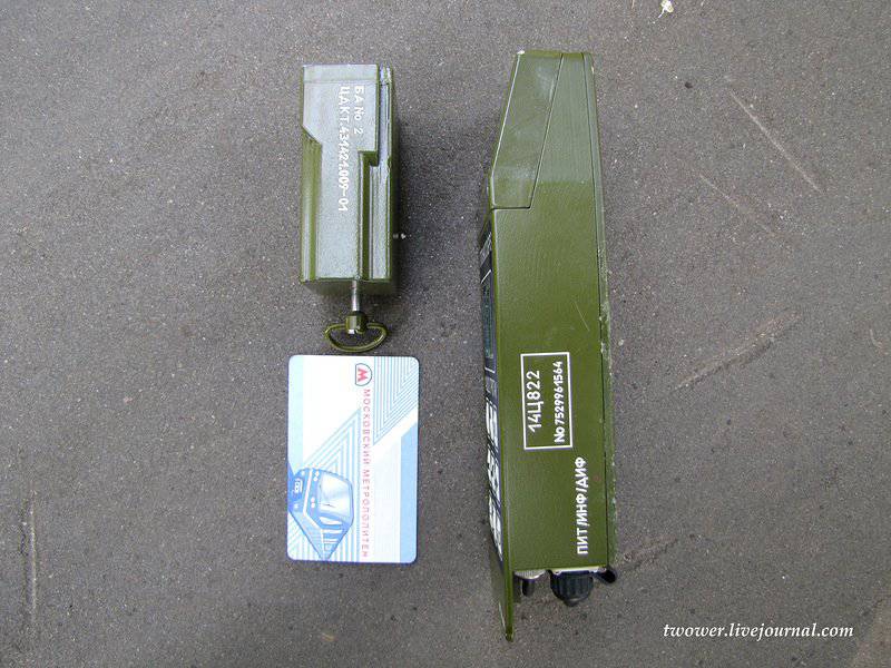
In the photo above are two GLONASS / GPS navigators of the Scientific Research Institute of Space Instrument Engineering: on the right - the previous generation 14Ц822 “Grot-M” equipment, on the left - a new sample, which has the same name as the previous one - “Grot-M”, but is the deepest modernization of the younger brother.
The first "Grotto", released in 2003, is in service with the Russian army, as well as several countries in Africa and Latin America (the navigator’s menu has English, French and Spanish localizations) and has an circulation of about 10 thousand copies. In our armed forces it is used mainly by the commanders of artillery units, reconnaissance, mountain arrows and special forces. According to the state, it is necessary to have him in the motorized rifle battalion, as well as company tactical groups operating in isolation from the main forces.
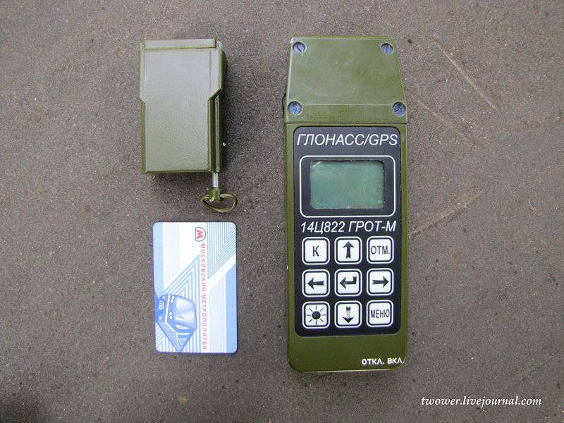
The case of the navigator is made of a single bar of aluminum by milling, which caused a high strength of the product, but at the same time significantly weighed it (the weight of the device was 800 grams). Since the device was originally intended only to determine the coordinates and solve problems in artillery, he received a small screen and did not support the display of maps. For convenience of work in a hard frost, when hands are in gloves, the navigator was equipped with large buttons that the end users liked very much - the military
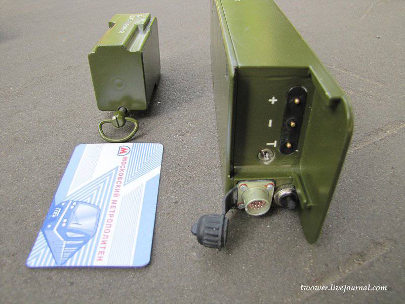
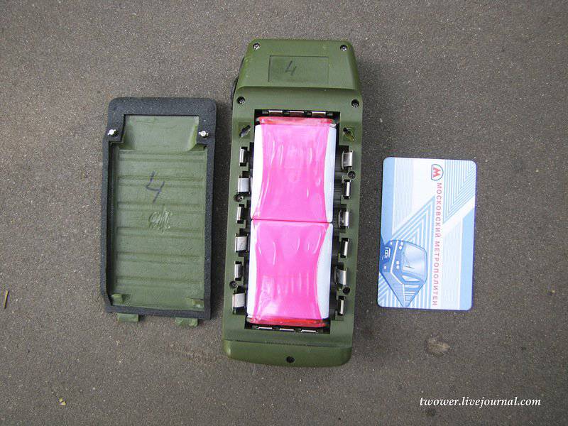
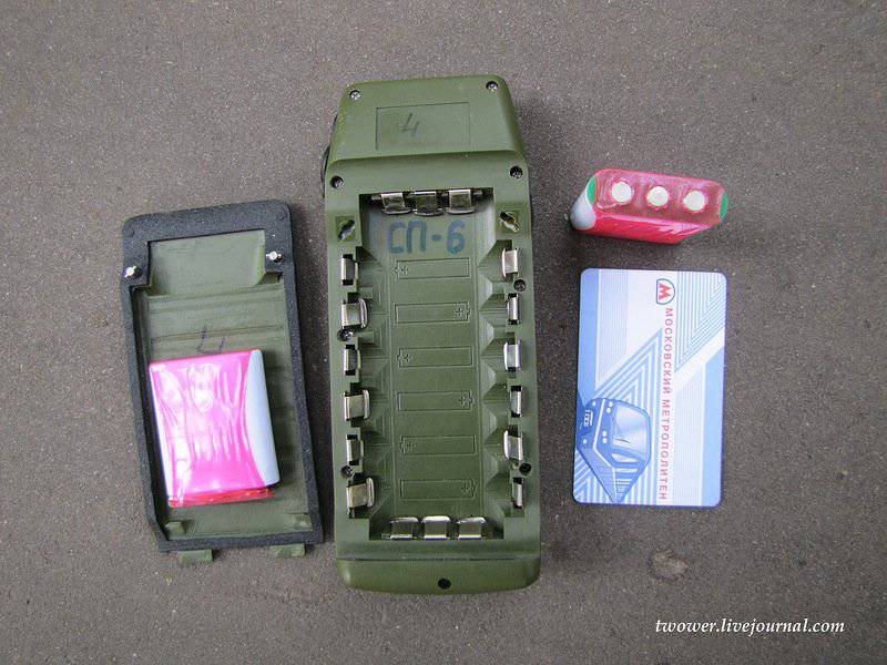
Included were two batteries, which, due to design features, extended the body to 25 cm
Since time does not stand still and technologies go ahead, the enterprise initiated a profound modernization of the navigator, which actually led to the creation of a completely new device, but under the same name - Grot-M. The product received a new 32-bit ARM processor, a large color display with a resolution of 320x240. The buttons were moved to the upper part of the navigator, since it is with this location that the device is most conveniently in the hand and pressing the buttons is most comfortable.
From the touch screen refused, because in cold climates and gloved hands it is simply useless.
The body has become plastic, power sources have found a different location.
Li-polymer batteries are used for 2500 mAh French production, because domestic battery manufacturers explained that they are very busy with orders and will not be able to deliver their products earlier than in several years
The navigator can work from one battery pack, but then its running time is reduced. When the air temperature is above zero degrees, the navigator operates around 18 hours continuously, at the lowest possible temperature for which it is designed (-30 degrees) - at least 12 hours.
In addition to the battery packs, the product can also work on ordinary AA batteries.
The navigator maintains being under water at a depth of 1 meter during the day and can then work.
"Grotto" can be connected to networks with low voltage (from 10 to 30 volts), which allows you to charge it from the onboard network of cars and armored vehicles. It is possible to charge battery packs both in the device itself and in a separate charger.
At the time of communication with the developers (August 2011), the power consumption of the navigator produced by the 130 nm technical process was 1.05-1.1 W (at the peak of work up to 1.2 W), but now there is updated data on the site that it is no more than 1 W, which means that the expected transition to the 110 nm process technology took place.
It should be noted that the power consumption of devices based on GLONASS will always be more than similar devices based on GPS, since the domestic navigation system uses a wider range of frequencies. A wide channel is harder to suppress by electronic warfare, but this plus is being exchanged for higher power consumption.
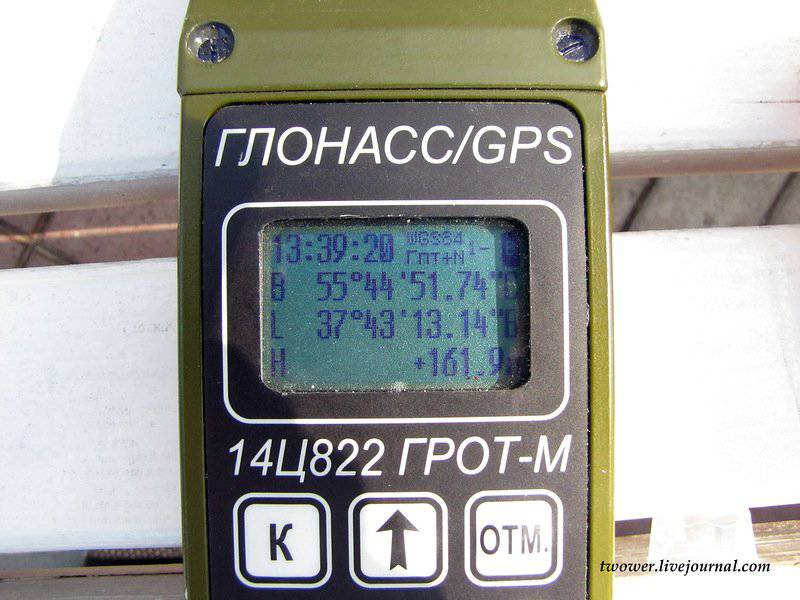
The navigator can work simultaneously with 32 satellites, which greatly improves the positioning accuracy. It (accuracy) depends on many factors (the number of satellites, the terrain, etc.) and for the "Grotto" is 10 m (operation mode, when interaction is only with satellites), which is comparable with similar indicators of the American military navigator DAGR. The differential mode is also implemented in the domestic navigator, which allows, using base stations, to increase the positioning accuracy to tens of centimeters.
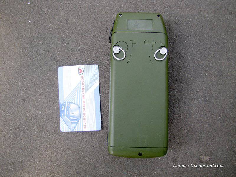
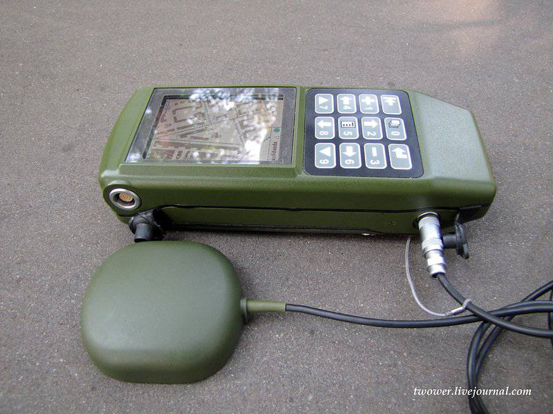
"Grot-M" with an external navigation antenna. The antenna has a magnet and can be used when driving in a car.
At the request of the customer it is possible to install a slot under the SD-card flash memory, but the military is not asking for such an opportunity. The internal memory of the device itself is 256 megabytes.
The favorite question of all readers was asked by me: "Whose production is the electronic component of the navigator?". The chip is entirely developed in the enterprise, except for the processor core, which was purchased under license. Digital circuit design, topology - all domestic, but the physical manufacturing - China, Taiwan. The installation of the board again takes place with us. Displays are also purchased abroad, because Belarusian developers (alternative to foreign countries) offer models with high power consumption, weight and cost.
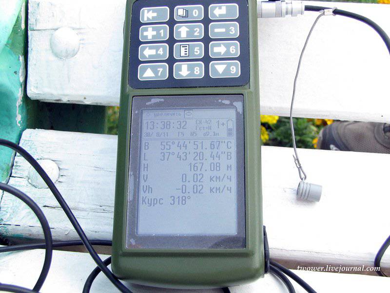
Navigator allows you to record the route and show it on the background of the map. Maps, routes can be poured into the device and removed from it through the USB interface (the port for USB, RS-232 and RS-485 is one, the splitter is included). Included with the product is software that allows the end user to match the navigator with operating systems based on Linux and Windows. It is assumed that, if desired, the user will be able to install any cards from third-party developers into the Grotto, using a special converter from the software bundle.
Navigator can solve service tasks that are necessary for the needs of gunners:
- the coordinates of the point to be fired are determined by given coordinates, distance and azimuth;
- the distance and azimuth between them is determined by given two pairs of coordinates;
- coordinates of the third point are determined by the coordinates of two points and the angle between them;
- measurement of the direction angle, etc.
It is possible to recalculate longitude and latitude into Gauss-Kruger coordinates and back.
Navigator menu example
At the moment, the Scientific Research Institute of Space Instrument Making, as an initiative, is developing a new model of the navigator, which will have to replace the wearable Grot-M and the portable model 14Ц821 Grot-V, which is now used on armored vehicles of the Russian armed forces.
In the photo above are two GLONASS / GPS navigators of the Scientific Research Institute of Space Instrument Engineering: on the right - the previous generation 14Ц822 “Grot-M” equipment, on the left - a new sample, which has the same name as the previous one - “Grot-M”, but is the deepest modernization of the younger brother.
The first "Grotto", released in 2003, is in service with the Russian army, as well as several countries in Africa and Latin America (the navigator’s menu has English, French and Spanish localizations) and has an circulation of about 10 thousand copies. In our armed forces it is used mainly by the commanders of artillery units, reconnaissance, mountain arrows and special forces. According to the state, it is necessary to have him in the motorized rifle battalion, as well as company tactical groups operating in isolation from the main forces.
The case of the navigator is made of a single bar of aluminum by milling, which caused a high strength of the product, but at the same time significantly weighed it (the weight of the device was 800 grams). Since the device was originally intended only to determine the coordinates and solve problems in artillery, he received a small screen and did not support the display of maps. For convenience of work in a hard frost, when hands are in gloves, the navigator was equipped with large buttons that the end users liked very much - the military
Included were two batteries, which, due to design features, extended the body to 25 cm
Since time does not stand still and technologies go ahead, the enterprise initiated a profound modernization of the navigator, which actually led to the creation of a completely new device, but under the same name - Grot-M. The product received a new 32-bit ARM processor, a large color display with a resolution of 320x240. The buttons were moved to the upper part of the navigator, since it is with this location that the device is most conveniently in the hand and pressing the buttons is most comfortable.
From the touch screen refused, because in cold climates and gloved hands it is simply useless.
The body has become plastic, power sources have found a different location.
Li-polymer batteries are used for 2500 mAh French production, because domestic battery manufacturers explained that they are very busy with orders and will not be able to deliver their products earlier than in several years
The navigator can work from one battery pack, but then its running time is reduced. When the air temperature is above zero degrees, the navigator operates around 18 hours continuously, at the lowest possible temperature for which it is designed (-30 degrees) - at least 12 hours.
In addition to the battery packs, the product can also work on ordinary AA batteries.
The navigator maintains being under water at a depth of 1 meter during the day and can then work.
"Grotto" can be connected to networks with low voltage (from 10 to 30 volts), which allows you to charge it from the onboard network of cars and armored vehicles. It is possible to charge battery packs both in the device itself and in a separate charger.
At the time of communication with the developers (August 2011), the power consumption of the navigator produced by the 130 nm technical process was 1.05-1.1 W (at the peak of work up to 1.2 W), but now there is updated data on the site that it is no more than 1 W, which means that the expected transition to the 110 nm process technology took place.
It should be noted that the power consumption of devices based on GLONASS will always be more than similar devices based on GPS, since the domestic navigation system uses a wider range of frequencies. A wide channel is harder to suppress by electronic warfare, but this plus is being exchanged for higher power consumption.
The navigator can work simultaneously with 32 satellites, which greatly improves the positioning accuracy. It (accuracy) depends on many factors (the number of satellites, the terrain, etc.) and for the "Grotto" is 10 m (operation mode, when interaction is only with satellites), which is comparable with similar indicators of the American military navigator DAGR. The differential mode is also implemented in the domestic navigator, which allows, using base stations, to increase the positioning accuracy to tens of centimeters.
"Grot-M" with an external navigation antenna. The antenna has a magnet and can be used when driving in a car.
At the request of the customer it is possible to install a slot under the SD-card flash memory, but the military is not asking for such an opportunity. The internal memory of the device itself is 256 megabytes.
The favorite question of all readers was asked by me: "Whose production is the electronic component of the navigator?". The chip is entirely developed in the enterprise, except for the processor core, which was purchased under license. Digital circuit design, topology - all domestic, but the physical manufacturing - China, Taiwan. The installation of the board again takes place with us. Displays are also purchased abroad, because Belarusian developers (alternative to foreign countries) offer models with high power consumption, weight and cost.
Navigator allows you to record the route and show it on the background of the map. Maps, routes can be poured into the device and removed from it through the USB interface (the port for USB, RS-232 and RS-485 is one, the splitter is included). Included with the product is software that allows the end user to match the navigator with operating systems based on Linux and Windows. It is assumed that, if desired, the user will be able to install any cards from third-party developers into the Grotto, using a special converter from the software bundle.
Navigator can solve service tasks that are necessary for the needs of gunners:
- the coordinates of the point to be fired are determined by given coordinates, distance and azimuth;
- the distance and azimuth between them is determined by given two pairs of coordinates;
- coordinates of the third point are determined by the coordinates of two points and the angle between them;
- measurement of the direction angle, etc.
It is possible to recalculate longitude and latitude into Gauss-Kruger coordinates and back.
Navigator menu example
At the moment, the Scientific Research Institute of Space Instrument Making, as an initiative, is developing a new model of the navigator, which will have to replace the wearable Grot-M and the portable model 14Ц821 Grot-V, which is now used on armored vehicles of the Russian armed forces.
Information